Part A Spatial Strategy - Draft Local Plan for Buckinghamshire (Reg 18)
Other elements in this consultation
3. Buckinghamshire
Spatial Portrait
On 1 April 2020, the former District Council areas of Aylesbury Vale, Chiltern, South Bucks and Wycombe and Buckinghamshire County Council came together to form a single Unitary Authority, Buckinghamshire Council.
Buckinghamshire is a richly diverse, enterprising, and attractive county. In Buckinghamshire there is a population of 553,078 people in 2021. This is an increase of 9.5%, from 505,283 in 2011 (ONS census data). This is higher than the overall population increase of 6.6% for England in the same period. The south of Buckinghamshire is densely populated, and the north is more sparsely populated, however, there has been a particularly large population change in Aylesbury Vale which has seen a 10.4% rise since 2011, the highest rate of growth of any local authority in Great Britain. Buckinghamshire has an ageing population with an increase of 23.2% in people aged 65 years and over between the 2011 and 2021 census. There has been an increase of 6.4% in people aged 15 to 64 years, and an increase of 7.9% in children aged under 15 years. For more see ONS census 2021 data. Statistics indicate that life expectancy within the most deprived areas is 5.4 years lower than within the more affluent areas for both men and women for Buckinghamshire.
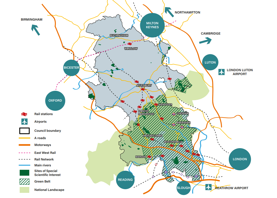
The council area is largely rural but includes a number of significant urban areas, Aylesbury and High Wycombe. Other market towns spanning the council area are Amersham, Beaconsfield, Buckingham, Chesham, Marlow, Princes Risborough, Wendover and Winslow.
Buckinghamshire Council covers an area of 604 sq. miles (1,564 sq. km) and includes parts of the metropolitan Green Belt and the Chilterns National Landscape. The Green Belt was introduced to restrain the urban sprawl of London, prevent the merging of towns, and to safeguard the countryside and character of historic towns. Designated Green Belt covers 32% of Buckinghamshire Council's area. Following an update to the NPPF, a Green Belt Assessment is currently underway to consider whether the Green Belt strongly meets the purposes of the Green Belt as identified by national policy. The Chilterns National Landscape is a valued landscape, and its designation is to conserve beauty through protecting flora, fauna, and geological features. It covers 27% of the Buckinghamshire Council area. Both the Green Belt and Chilterns National Landscape affect the scale and types of development that can happen within these areas.
Buckinghamshire is well connected to the existing road and rail network, including the M40, M25 and M4 motorways, London underground and national rail services which run north to south. High Speed Rail 2 (HS2) is under construction through the county, from London to Birmingham. East West Rail (EWR) is under construction to connect Oxford to Milton Keynes and Bedford with a new station due to open at Winslow in 2025. HS2 and EWR cross at Calvert in the north of the county. With the exception of EWR and the Elizabeth line, transport links north to south are generally superior to those which traverse the county from east to west. Buckinghamshire is also well located to London Heathrow and London Luton airports.
Buckinghamshire has 220,727 households (ONS Census 2021) with 71% owning their home outright or with a mortgage. The average house price is £479,000 as at January 2025, a 2.6% rise from the previous year (ONS data). In 2024 the affordability ratio was 11.3%, ranking Buckinghamshire as the 55th most unaffordable place to live in England and Wales.