Part B Development Management Policy - Draft Local Plan for Buckinghamshire (Reg 18)
Other elements in this consultation
2. Development Management Policies - Transport
2.44 Transport requirements in new developments
2.44.1 Transport facilitates the movement of people between their home, work, shops and services, including education, across Buckinghamshire and beyond. It supports sustainable growth opportunities, inward investment, regeneration and contributes towards the delivery of sustainable development. The way we move also affects our health as individuals and as a community.
2.44.2 Buckinghamshire being a predominantly rural area, many residents and workers often have limited travel options other than the private car (i.e. infrequent bus services due to financial viability, distance means that walking/cycling not an option). Car ownership in Buckinghamshire is higher than the national average. Traffic congestion is a key issue disrupting people's everyday journeys and impacting on the local economy. Traffic congestion is predicted to increase across the county if current travel patterns continue. Through the Local Plan, the Council will need to ensure that the right infrastructure is in place to support future demand and in step with the growth in the area. In order to address these challenges, plan-making and planning decisions should consider many aspects of transport need to improve people's transport choices and enable people to choose sustainable transport modes3, whilst understanding that car use may be the only viable option for some journeys (particularly in rural locations). This will help to tackle congestion, reduce carbon emissions and create healthy and thriving neighbourhoods.
2.44.3 To achieve this broader consideration of transport needs and ensure people have real travel choice, we need to take a different approach to previous plans. The policies in this Chapter are therefore based on a vision-led place-based approach to shape future development and transport infrastructure in Buckinghamshire.
2.44.4 A place-based approach to net zero transport should focus on solutions that create well-connected places and healthier, happier, more resilient communities. These objectives are critical to good planning, linking the imperative to reduce transport emissions with wider objectives related to decarbonisation, sustainable housing and employment growth and nature recovery.
2.44.5 This approach identifies the need to follow a sustainability hierarchy in terms of transport needs: substitute (avoid), shift and switch/ improve. It is however recognised that connectivity by motorised vehicles, particularly on a strategic level, is essential in facilitating many journeys.
2.44.6 This basic hierarchy is summarised in the "Sustainable Accessibility and Mobility (SAM) Framework"[16] below, which seeks to prioritise interventions in the following order:
- Substitute Trips: replace the need to travel beyond your community: Do I need to travel, can I do it online?
- Shift Modes: Could I walk, cycle, or use public transport?
- Switch Fuels: If I need to use the car, could it be alternative fuel?
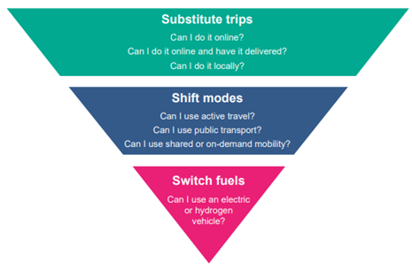
Figure 7 - Source: rtpi-net-zero-transport-january-2021.pdf
2.44.7 To help achieve this, the location of development in sustainable locations, and the supply of accessible sustainable transport modes, including walking, wheeling and cycling, will be prioritised. Roads will be carefully designed to support developments and minimise severance.
2.44.8 We will also work in partnership with National Highways, Network Rail, Great British Railways Transition Team, Active Travel England and others to bring forward improvements to strategic transport infrastructure, services and freight movements. This will support local travel movements and also strategic.
TR1 Transport requirements in new developments
Vision-led transport planning
1. All new developments are required to embed the principles of the transport sustainability hierarchy, the Council's vision-led approach to transport planning, and the Local Transport Plan. Where transport modelling is required, a range of plausible scenarios will need to be considered in line with a defined vision.
Delivering the vision
2. Transport Statements or Transport Assessments will be required to demonstrate how the development will positively contribute to sustainable travel and strategic access. Where appropriate, developments will be required to:
Walking, wheeling and cycling
- prioritise provision of routes within the site for pedestrians, those with impaired mobility, non-motorised vehicles and cyclists, which are designed to be coherent, direct, safe, comfortable and attractive;
- Provide new coherent, direct, safe, comfortable and attractive access to the site on foot, by cycle and other non-motorised vehicles, maximising connections with local services (including schools) and destinations and with existing footways, public footpaths, bridleways, restricted byways and cycle ways. Whole route assessments will be required for a range of services and full integrated routes should be provided addressing shortfalls in these routes;
- provide safe, direct and accessible walking, cycling and wheeling routes to local schools following Road Safety GB standards or replacement;
- provide dedicated changing and showering facilities in any new non-residential building over 2,500m2 of net internal floorspace.
Public Transport
- provide access to a high quality, fully accessible, attractive public transport service.
- provide a new or enhanced service where development is not already served by a high-quality attractive bus or train service. This may be provided directly or by way of a financial contribution, so that the service is maintained for a period of at least five years from an agreed occupation level.
Travel plans
- provide and implement travel plans that set out the long-term travel management strategy for an organisation or site, built on an appropriate package of measures aimed at promoting sustainable travel. They must include modal share targets and mitigation measures, in accordance with the Council's guidance.
Car clubs
- provide car club infrastructure in the form of parking spaces, drop off and pick up points and, where appropriate, car club vehicles or provision of subsidised cost of car club membership for electric vehicles, in accordance with the Council's car club guidance.
Car sharing
- provide priority parking spaces for car sharers at developments that are primarily destinations (i.e. non-residential uses).
Mobility Hubs
- deliver mobility hubs in accessible locations which are close to community facilities on site and provide sustainable transport connections to wider services, in accordance with the Council's guidance.
Road Infrastructure
- provide strategic road improvements where required, ensuring minimal severance and connectivity provisions.
Highways safety
3. Development will be supported where there is no demonstrable unacceptable impact on highway safety, or the residual cumulative impacts on the road network, following mitigation, would be found less than severe, taking into account all reasonable future scenarios.
Design Requirements
4. Design of transport in new developments is required to:
- allow for bus routes through the site and priority routing of buses onto the main traffic network,
- include traffic management to mitigate any safety issues within and accessing the site, and any impacts of the development traffic on the main highway network.
- deliver a layout and design of transport infrastructure that creates high quality, permeable, coherent, safe and locally distinct places. Maximising opportunities for walking, wheeling and cycling should be given priority, followed by the needs of vehicular traffic.
Vision-led transport planning
2.44.9 The first part of the policy sets the strategic context for transport planning in Buckinghamshire. As an approach, a way of thinking or mindset, a vision-led approach to transport planning is relevant to all scales of development and its application can be tailored accordingly. Therefore, all new developments need to contribute at scale to the transport objectives of the Local Plan and adopted Local Transport Plan. Where sites are allocated, the vision is set in the Plan.
2.44.10 Transport modelling will still be necessary in vision-led transport planning. Developers will be required to model a range of plausible scenarios which assume different assumptions about trip generations and mode shifts.
2.44.11 Plausible scenarios will be based on:
- characteristics of the proposed development site's location,
- its existing connectivity,
- the mitigation or connectivity improvements that will be either delivered directly by the site developers or through financial contributions towards Buckinghamshire Council's schemes and
- the extrapolation of trends in travel behaviour.
2.44.12 Developers will need to engage at the earliest opportunity with the Highway and Planning Authorities to agree on a vision-led methodology.
2.44.13 The Council will develop further guidance on vision-led transport planning.
Delivering the vision
2.44.14 The second part of the policy applies to any development proposal which requires the submission of a transport statement or transport assessment as set out in the Department for Transport guidance.
2.44.15 Transport Assessments and Transport Statements primarily focus on evaluating the potential transport impacts of the development proposal and the scope/impacts/mitigation will vary from site to site. They may also consider net reductions of impacts and therefore no mitigation is required.
2.44.16 Sustainable modes of transport should be prioritised in new developments to promote accessibility and integration with the wider community and existing networks. Priority should be given to walking, cycling, wheeling and access to public transport including the provision of new or enhanced existing bus services. It should be easier and quicker to walk, wheel or cycle to key locations across the site (and nearby) in order to encourage walking, wheeling and cycling to be the first choice for short trips. New developments need to consider access to and provisions at local rail stations to ensure that they can accommodate increased rail demand.
2.44.17 Developers should ensure that all schools on new developments have safe, direct, accessible walking and cycling routes both within the development and also take into account routes children and young people might take into schools on new developments from outside the development.
2.44.18 People also need access to open spaces and recreational facilities and should be able to easily get there by walking/bike. These spaces are in their own right going to be used for walking/cycling, therefore provisions should be made for walking/cycling routes through all green spaces.
2.44.19 Developers will need to refer to the latest detailed guidance from the Highway Authority, including on Travel Plans6, Car Clubs and Mobility Hubs. Cycling provision must follow LTN1/20 guidance, or any future update to it, subject to safety requirements.
2.44.20 The vision-led approach recognises that journeys by car will still be required. To support those that need to drive, measures should be included to encourage zero emission vehicles, car sharing, and reduce journey lengths such as mobility hubs. The design of developments should also ensure motor vehicle movements are routed appropriately.
2.44.21 To ensure that all transport users needs are considered and genuine travel choice is provided in new developments, highway upgrades for cars / HGV use should only be considered after all other options have been explored.
2.44.22 A car club provides access to private vehicles for hire. The cars are usually parked in reserved parking spaces specifically for car club vehicles. They provide more sustainable vehicles and travel choice.
2.44.23 The guidance will support the parking standards and will outline the benefits of car club schemes, the types of schemes, operational models and management, and the parking space requirements (location, infrastructure and design).
2.44.24 A mobility hub is a physical location that facilitates the integration of multiple transport options e.g. buses, trains, bicycles, e-scooters and carsharing services making it easier for people to switch between different types of transport. In Buckinghamshire, mobility hubs will facilitate and enhance connections between new developments, existing rail and bus interchanges and key tourist and employment zones.
2.44.25 Where and how mobility hubs are implemented will vary depending on specific site constraints, existing transport provision, user demand, future transport and economic trends. Developers should refer to the mobility hub guidance to ensure that the right mix of sustainable transport modes are viably implemented.
2.44.26 The Council is currently developing Mobility Hub guidance as part of LTP5 which will outline the types of mobility hubs, where they are likely to apply and the proposed mix of components for each mobility hub types. The guidance will outline minimum requirements that each mobility hub must meet.
Highway safety
2.44.27 In line with the NPPF, developments should not have a severe adverse impact on the network. Mitigation following a vision-led approach will need to be provided as appropriate.
Design requirements
2.44.28 Detailed design requirements will need to be discussed and agreed at the earliest opportunity with the Highway Authority.
This policy sets out the requirements for new developments in terms of following a vision-led approach and providing active travel and sustainable transport.
2.45 Transport improvements
TR2 Transport improvements
1. Development will not be supported where they would prejudice the provision of new or improved transport infrastructure on the Transport Improvement Lines identified on the council's website.
2. Major development sites are required to identify, protect and help to deliver strategic transport infrastructure, both existing and new, where there is robust evidence the infrastructure is critical to widening transport choice and realising opportunities for large scale development.
2.45.1 In line with the Highway Authority priorities, the local plan formally safeguards Transport Improvement Lines through this policy to ensure that that no development could prejudice the delivery of these schemes.
2.45.2 The Council will not permit development that would prejudice the implementation of any of the schemes safeguarded by the Council (see transport improvement lines on the website). There are different types of road and junction improvement lines and they are required to provide improvements to road networks, to increase road capacity, improve road safety, as well as creating additional public transport or non-vehicular routes for walking, wheeling and cycling.
2.45.3 In addition, major development sites are required to identify, protect and deliver strategic transport infrastructure where there is robust evidence it is critical to widen transport choice or support delivery of large-scale development. Strategic transport infrastructure may be required to improve the current transport network or support future travel requirements.
2.45.4 Strategic transport infrastructure includes new roads, improvements to road networks and creation of additional public transport or non-vehicular routes for walking, wheeling and cycling. Infrastructure will be delivered on site or through contribution towards its delivery. Due to the nature of Buckinghamshire, roads will remain an important part of transport infrastructure.
2.45.5 Strategic transport infrastructure does not include rail which is considered separately through the safeguarded land policies.
This policy sets out the requirements for major developments to identify, protect and help to deliver strategic transport infrastructure, both existing and new.
2.46 Parking standards
TR3 Parking standards
Development proposals are required to comply with the latest Buckinghamshire Parking Standards* and the parking standards and design principles in the national model design code.
*Parking standards are currently being reviewed, and this policy refers to these future standards, not the current ones.
2.46.1 Car parking and its location has an impact on the quality of the environment – how it looks, how it functions – and on safety. The availability and convenience of parking at the destination can have a real effect on the choices people make regarding travel.
2.46.2 Policies within the National Planning Policy Framework (NPPF) have given local authorities the flexibility to tailor parking provision based on local market demands, community needs and future transport ambitions. Buckinghamshire's Local Transport Plan sets out the local priorities for promoting modal shift and influencing the quality and character of local streets. The Parking standards takes the many demographic and economic variations in Buckinghamshire's urban and rural areas as well as the significant variations in accessibility of public transport and reflects these variations in the parking standards to ensure adequate parking provision.
2.46.3 Development proposals will be required to comply with the latest parking standards to ensure that parking provision (including designs and layouts) are implemented for the benefit of all users.
2.46.4 Current vehicle parking standards, including for cycles and motorcycles, are on the council website. An update to the Parking Standards is under way, and is expected to be completed next year. We wish to encourage electric vehicle charging infrastructure to support all electric vehicles in use. Electric vehicle infrastructure requirements will be defined as part of the new Parking Standards being prepared.
This policy sets out the principle for following the future parking standards requirements for new developments.
2.47 Public rights of way
TR4 Public Rights of Way
1. Development will be required to:
- Protect and enhance public rights of way to ensure the integrity and connectivity of this network is maintained.
- Ensure the safe and convenient use and enjoyment of existing public rights of way, such as footpaths, bridleways and restricted byways, is maintained.
- Avoid unacceptable harm to the efficient operation of public rights of way.
2. Proposals should accommodate existing access routes on their original alignment through green corridors. If diversions are required to enable a proposal to come forward, this will only be supported if the safety and convenience of the route is of similar or greater merit than the existing.
3. Upgrade the status of public rights of way to maximise sustainable transport networks, where necessary, to allow additional use by cyclists.
4. New routes used for active travel, both on- and off-site, should be upgraded to adoptable standard to support increased use, providing an attractive travel choice. They should be safe by design and overlooked by active frontages.
2.47.1 As of June 2025, there are 2,084 miles of Public Rights of Way in Buckinghamshire which form the primary means by which residents and visitors access the countryside, but also schools and workplaces. Management of the network is guided by the Buckinghamshire Rights of Way Improvement Plan 2020-2030, which acknowledges the network's critical role in the rural economy.
2.47.2 Public Rights of Way are complimentary to the footway and cycleway network for walking and cycling which will contribute to the delivery of the Buckinghamshire Local Cycling and Walking Infrastructure Plan (LCWIP).
2.47.3 The Local Plan will seek to protect this resource and ensure improvements or enhancements are secured through the planning process to encourage active travel by new residents and discourage short journeys by car.
2.47.4 The protection and conservation of public rights of way need to be reconciled with the benefits of new development, to maximise the opportunity to form links from the development to the wider public rights of way network, public transport, recreational facilities and green infrastructure.
2.47.5 When delivering sustainable transport solutions for strategic sites, there may be instances where it is necessary to upgrade Public Rights of Way as an alternative to the Highway network. For example, to use a section as a cycleway as well as footpath.
2.47.6 Any changes to a Public Right of Way will require a separate legal process, either under s257 Town and Country Planning Act 1990 (as amended by subsequent legislation) if impacted directly by a development's footprint or otherwise under s119 Highways Act 1980 (as amended by subsequent legislation). The diverted route should be of similar or greater merit than the existing.
2.48 Freight and logistics
TR5 Freight and logistics
1. Facilities that enable sustainable freight activity and first mile / last mile solutions, in accordance with the adopted Local Transport Plan, will be supported.
2. Smart warehousing through retrofitting of existing stock will be supported.
3. New proposals (temporary or permanent) for freight and logistics movements should not have a significant detrimental impact on the local area.
4. Developments with retail or food-retail must ensure suitable access arrangements, loading and unloading facilities are provided.
5. Employment sites must have suitable facilities and access arrangements for ongoing freight deliveries.
2.48.1 Local authorities are required to plan for the modern economy; this includes freight and logistics. Freight is essential for servicing industry, communities, and supporting economic development. The Council is working on updating its Freight strategyalongside the emerging Local Transport Plan 5.
2.48.2 The transportation of goods by freight (road and rail) plays a key role in servicing Buckinghamshire's industry, communities and enabling our growth and economic development. Freight offers our residents choice as consumers and businesses: allowing them to grow, thrive and develop.
2.48.3 Whilst we recognise the importance of freight, there are also local challenges with the movement of goods by road. This includes freights contribution to transport carbon emissions and local traffic or road safety issues. Therefore, where deliveries are required, developments need to ensure appropriate access, loading and unloading arrangements. We will also support measures to enable sustainable deliveries and contribution towards our net zero ambitions.
2.48.4 As the most established modern economy presence within Buckinghamshire [freight and logistics dominate the employment figures at both the Buckinghamshire and national level, representing 72.1% of modern economy roles in Buckinghamshire in 2023], there are many businesses within the wider freight and logistics supply chain. Most prominently, these businesses are wholesalers, including pharmaceuticals, food and agricultural products, and office machinery and equipment.
2.48.5 These businesses positioned along key road connections, with clusters in and around the main settlements and business parks.
2.48.6 The Council is involved in developing a regional freight strategy as part of its involvement in England's Economic Heartland.
2.48.7 Buckinghamshire's relative lack of strategic freight infrastructure such as ports, airports, and rail freight terminals places limits its potential comparative advantage in the sector. Conversely, logistics, which includes warehousing and storage, demonstrates considerably stronger demand conditions, indicative of excess demand for logistics services.
2.48.8 The Employment Land Review Modern Economy Report has concluded that there is a need for smart warehousing via retrofitting of existing stock (pre-2000 for most) which would improve their efficiency through digitalisation and automation.
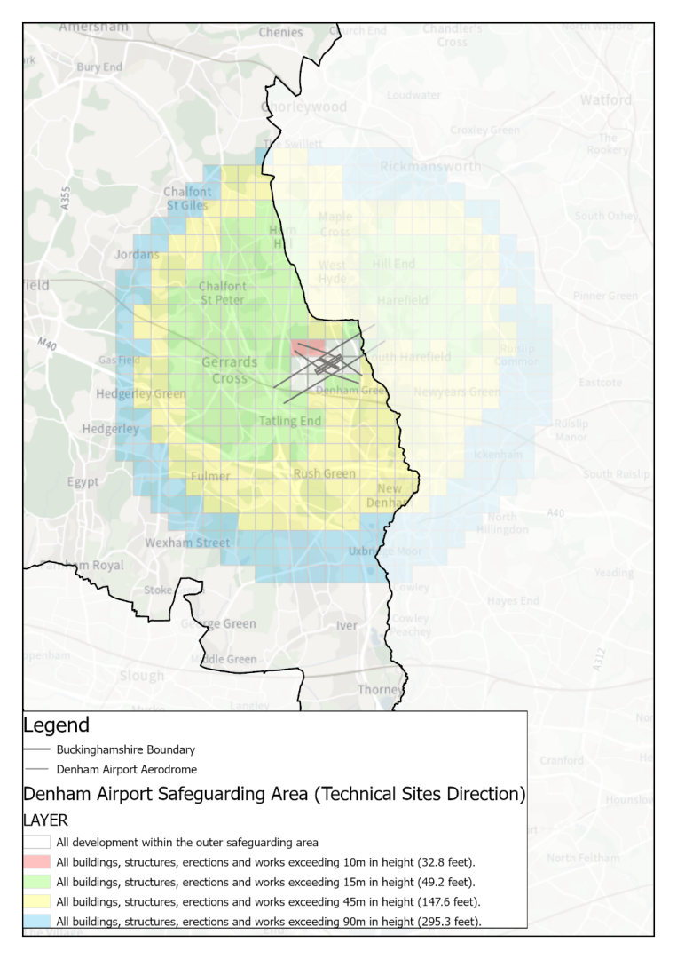
2.49 Aviation development
TR6 Aviation development
1. Aviation development that affects Buckinghamshire, including flight paths and construction traffic, will only be supported where it would not have a significant adverse impact on:
- the environment, landscape, nature conservation interests and
- residents and businesses in terms of noise, adverse lighting, residential amenity, public rights of way, or health and safety.
2. Diversification of operational airfields to include wider economic uses is supported, provided it does not prejudice or limit their effective operation.
3. Any proposed development within a statutory or non-statutory Safeguarding Zone will need to be safely designed in accordance with each aerodrome safeguarding maps.
2.49.1 The Council will seek to mitigate severe impacts from aviation developments where applicable. National guidance to local planning authorities is included in the DfT's general aviation handbook[17].
2.49.2 Local airfields are important local facilities. On small airfields such as Denham or Wycombe Air Park the Council will seek to ensure that proposals do not prejudice the operational users already in place.
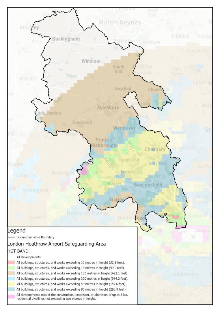
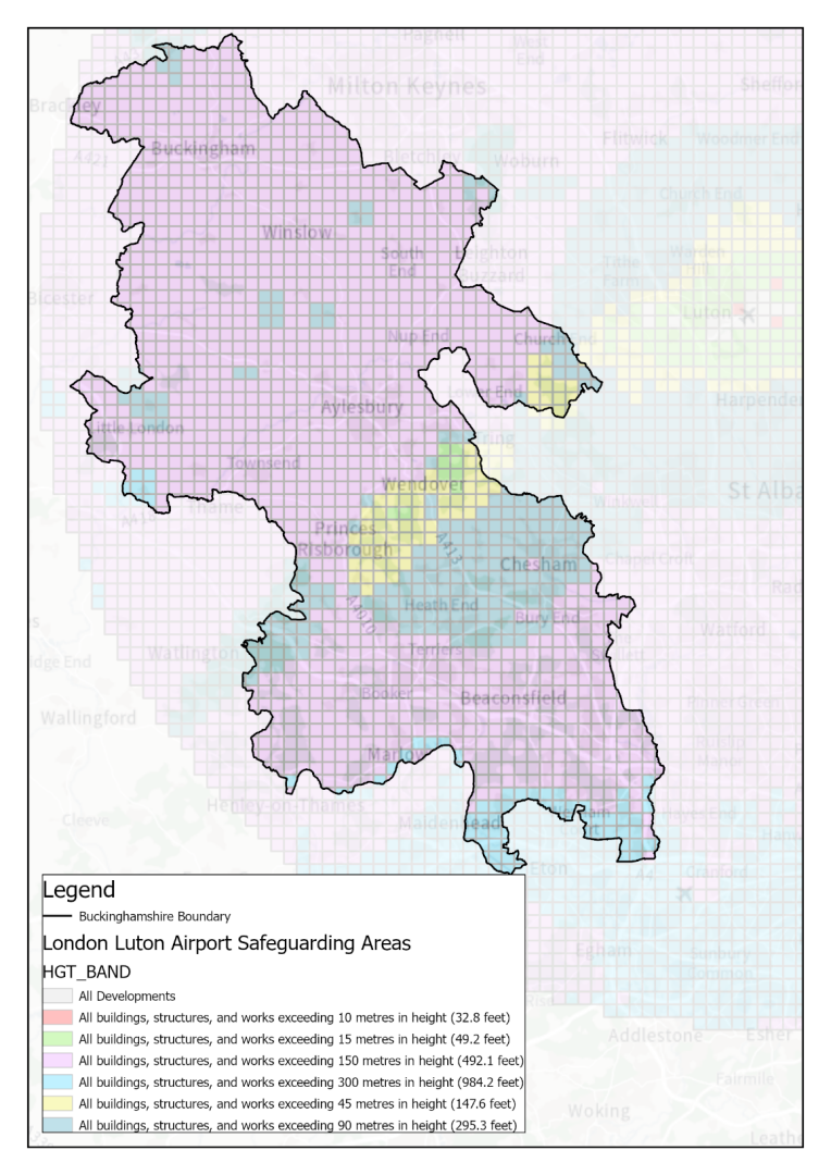
2.49.3 In relation to major airports in adjacent authorities, namely Heathrow and Luton, development in Buckinghamshire should not prejudice the safe operation of these international airports.
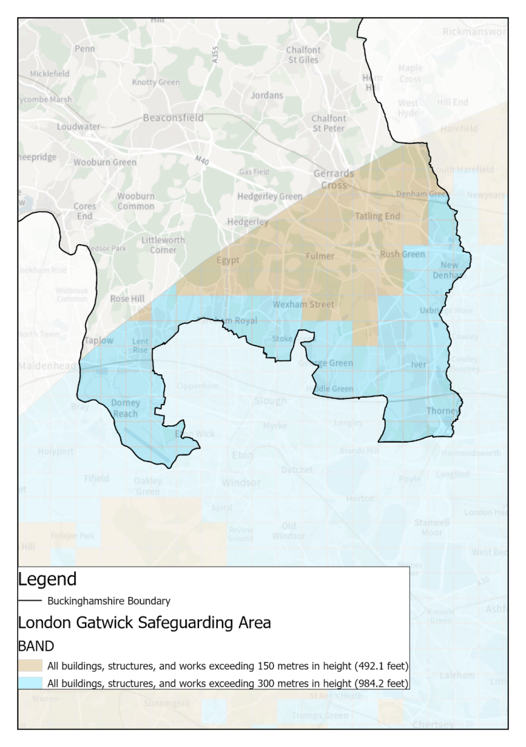
2.49.4 There are a number of statutory and non-statutory aviation safeguarding zones from airfields within Buckinghamshire, as well as airports and airfields within neighbouring authorities. Safeguarding zones are identified by each aerodrome based on their operational requirements. Any proposed development within an identified Aviation Safeguarding Zone will be subject to consultation with the operator of the aerodrome and the Ministry of Defence. Restrictions in height, placement of buildings and equipment or changes to the detailed design of development may be necessary to mitigate the risk of aircraft accident and interference with equipment to maintain operational integrity.
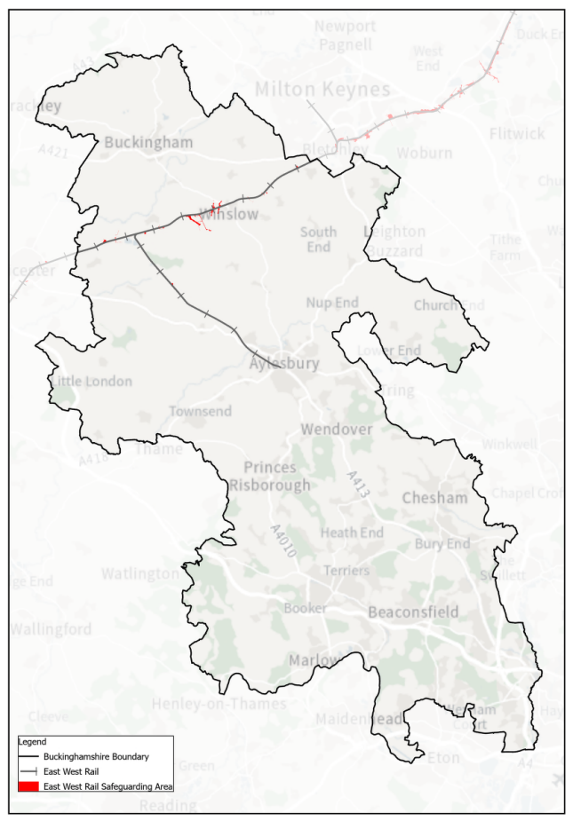
2.50 East West Rail
TR7 East West Rail
1. Any development which would prejudice the delivery of East West Rail, including the Aylesbury- East West Rail Link, will not be supported.
2. Development should also enable future overhead line electrification of the route without major civil engineering works e.g. removal or reconstruction of permanent structures.
3. Development of land adjoining the Princes Risborough to Aylesbury railway line must not prejudice the future double-tracking of the line.
4. New structures introduced across the line shall make passive provision for future double-tracking.
2.50.1 The delivery of East West Rail is vital for the subregion's prosperity and for improving sustainable travel alternatives to the car for commuting and leisure.
2.50.2 The East West Rail (EWR) project will provide a new east-west orbital route between the east of England and south-central England making use of existing infrastructure where available. The EWR project is aiming to provide connectivity to Reading, Didcot, Oxford, Bicester, Aylesbury, Milton Keynes, Bedford, Cambridge, Norwich and Ipswich and supports sustainable growth across the corridor. The council is one of a consortium of local authorities in England's Economic Heartland (the subnational strategic transport body) working with Network Rail and the Department for Transport, influencing and supporting the early implementation of this key infrastructure project.
2.50.3 The East West Rail western section (Phase 2) involves the upgrade and reconstruction of sections of line linking Bedford to Bicester and Milton Keynes, via Winslow. This will allow passenger and freight services to run between Bedford, Milton Keynes, Bletchley and Bicester, with a new station in Winslow. EWR are also proposing passing loops for freight near Middle Claydon.
2.50.4 East West Rail Phase 1 Bicester to Oxford is in operation and preparation for Phase 2, Bicester - Milton Keynes is well advanced. Train services are due to commence operation in the latter half of 2025.
2.50.5 Proposals by EWR Co and the Department for Transport do not currently include provision for the Aylesbury-East West Rail Link. This would provide a connection from Aylesbury to East West Rail, enabling direct services from Aylesbury and Aylesbury Vale Parkway to Winslow, Bletchley, Milton Keynes and other destinations further east. Services would run via an upgraded existing freight-only line north from Aylesbury Vale Parkway, joining East West Rail at Claydon West Junction. Provision for the Aylesbury Link is already being partially delivered by HS2 as part of its work in the Calvert and Claydon area.
2.50.6 The Council strongly supports delivery of the Aylesbury Link-East West Rail Link, including a continuous two-track railway corridor between Aylesbury railway station and Claydon West Junction, and provision for future overhead line electrification (OLE). It is appropriate to ensure that development adjoining the line does not prejudice this. In that context, all planning applications within 50 m of the branch line will be subject to consultation with Network Rail.
2.50.7 The Princes Risborough to Aylesbury branch is a single-track line with speed restrictions serving Monks Risborough and Kimble. Double-tracking this branch line is outside of the scope of current projects but was identified by Network Rail in their West Midlands and Chilterns Route Study 2017.
2.50.8 The indicative Train Service Specification for 2043 developed to support Network Rail's route study shows a requirement for up to three trains per hour along the line, in place of the current one train per hour. This level of service would require the line to be doubletracked. Increasing the train paths to two an hour could be a requirement sooner than this, within the plan period. This increase in capacity is required to support the planned level of sustainable growth across the Chilterns network area.
2.50.9 The Council strongly supports the mid to long-term aspiration of Network Rail to double-track the Princes Risborough to Aylesbury line. It is appropriate to ensure that development adjoining the branch line does not prejudice this. In that context, all planning applications within 50 m of the branch line will be subject to consultation with Network Rail.
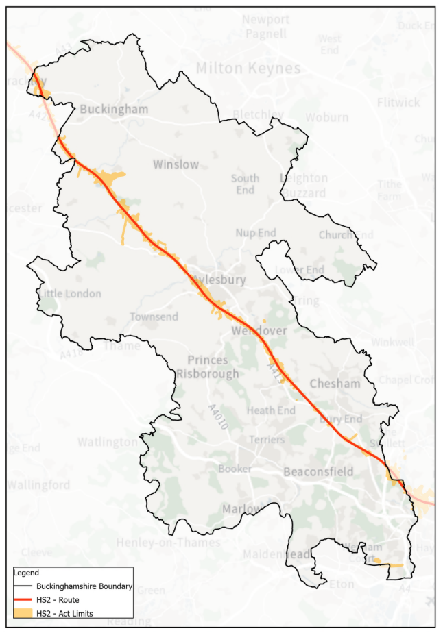
2.51 High Speed Two
TR8 High Speed Two
1. Development which would prejudice the implementation of High Speed 2 (HS2) will not be supported.
2. New development which impacts on the implementation of HS2 will be expected to:
- Manage its construction to minimise the impact on communities and the environment; and
- Make use of careful design to protect communities and the environment from noise, visual intrusion, loss of accessibility and impacts on biodiversity, mitigating unavoidable impacts where practicable.
2.51.1 High Speed 2 (HS2) is a national infrastructure project that will link London to Birmingham. The Secretary of State for Transport issued a safeguarding direction for the route between London and Birmingham in July 2013. The HS2 Bill received Royal Assent in February 2017.
2.51.2 The safeguarded land runs through the centre of the county and will be defined on the Policies Map in the final plan. The safeguarding directive requires the notification to HS2 Ltd of any planning application which affects the safeguarded land.
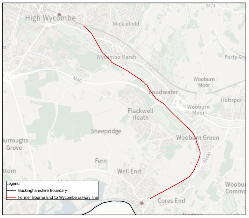
2.52 Former Bourne End to High Wycombe to railway line
TR9 Former Bourne End to High Wycombe railway line
1. The former Bourne End to High Wycombe Railway Line is proposed as a new walking / wheeling /cycle route.
2. Developments will not be supported where they would prejudice the construction of a 5m wide walking, wheeling and cycling corridor between Bourne End and High Wycombe town centre/railway station, utilising the track bed of the Bourne End to High Wycombe disused railway line. This route is to be separated from vehicular traffic where practicable. If in creating this new route, it is necessary to make diversions from the former railway track bed, the route chosen should not be significantly less direct or attractive.
3. The development of major sites (10 or above) within 800 metres of the corridor will be required to provide convenient links to the route (and sections of the route where appropriate), in order to maximise the opportunities for walking, wheeling and cycling.
4. Any future development proposals that would prejudice construction or operation, or prevent suitable diversions being created to provide the walking, wheeling and cycling corridor, will not be supported.
2.52.1 The track between High Wycombe and Bourne End was closed in 1970 and has been safeguarded since 1976. The Delivery and Site Allocations Plan for the former Wycombe District safeguarded the route in 2013 for its potential to be developed as a high-quality public transport corridor.
2.52.2 A study[18] recommended that "the relevant local authorities should prevent further development along the alignment, so that the route is preserved in the event of the case for the re-instatement of public transport route here strengthening in the future."
2.52.3 Following further work the Council considers that the prospects for a public transport route being created are now very unlikely. However, the route does offer great potential as a walking and cycling route as it is direct and well connected to homes, schools, jobs, railway stations, open space and town/district centres on a largely flat, largely traffic free route through an attractive landscape. The route – much of which remains undeveloped - is therefore safeguarded for the provision of a dedicated walking/wheeling/cycling route. The route also has potential to enhance green infrastructure. It is identified in the emerging Local Nature Recovery Strategy as an Area that Could Become of Particular Importance for Biodiversity.
2.52.4 Creation of an active travel route along the former railway line would deliver economic and health benefits by encouraging cycling, wheeling and walking and could form part of the Sustrans National Cycle Network. Its route along the valley floor is well positioned, as it runs through/is adjacent to urban areas for almost all its length – close to schools, houses, work places, rail stations and town /district centres, so it could be used for all types of cycling and walking journeys and in many places could be separated from vehicular traffic in order to make this route more attractive to users. Studies have shown it is not otherwise practicable to meet modern design standards for a cycle route between High Wycombe and Bourne End.
2.52.5 The Council will seek delivery of convenient links to the route, and sections of the route where appropriate, through direct delivery or s106 contributions as necessary. To this effect, a buffer of 800 metres from the corridor boundary is proposed to capture s106 contributions from major sites (10 or more). This corresponds to a 10 minutes' walk / 3 minutes cycling and is deemed reasonable.
[18] Atkins, Thames Valley multi-modal study (2003)


