Draft Housing and Economic Land Availability Assessment Methodology (June 2022)
3.0 METHODOLOGY
3.1 The PPG published in March 2014, and updated in July 2019, contains detailed guidance on an appropriate methodology for the assessment. This reaffirms the advantages of carrying out land assessments for housing and economic development as part of the same exercise and that such an assessment should:
- Identify sites and broad locations with potential for development;
- Assess their development potential; and
- Assess their suitability for development and the likelihood of development coming forward (the availability and achievability).
3.2 Figure 1 is the flow chart from the PPG which sets out a five-stage process for undertaking HELAAs.
Figure 1: National Planning Practice Guidance Housing and Economic Land Availability Assessment Methodology Flow Chart[4]
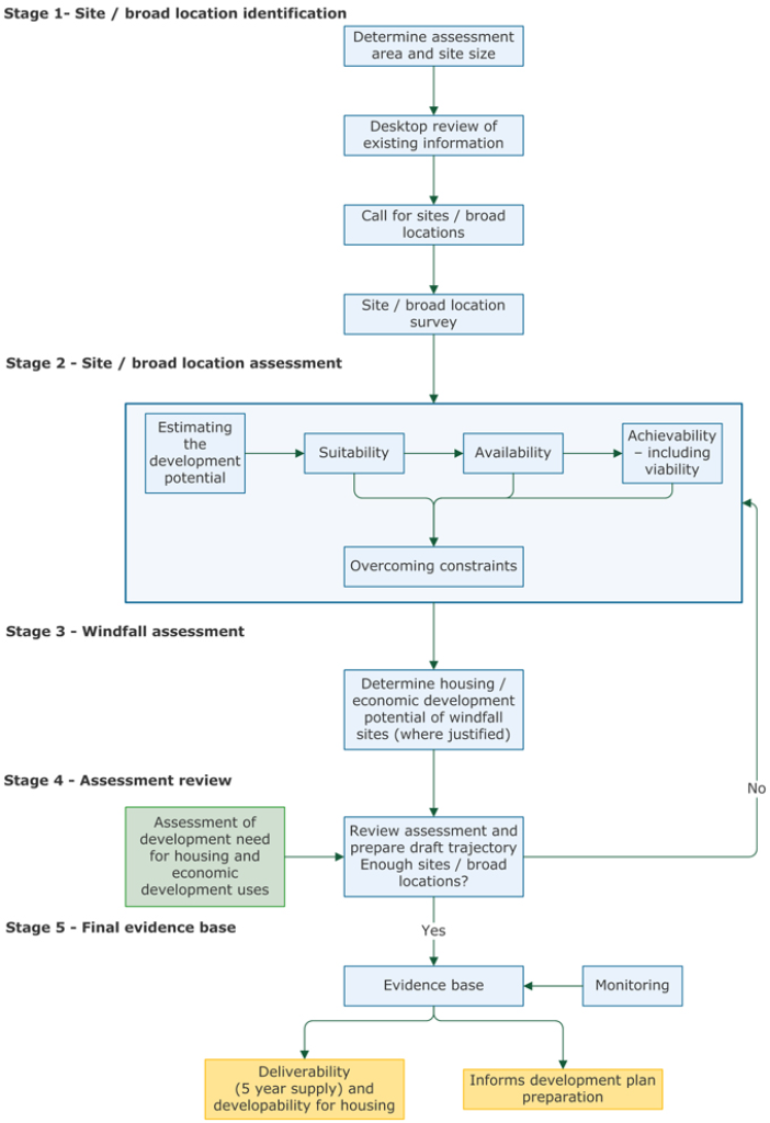
Summary of the steps included in the flow chart (Figure 1):
Stage 1: Site/broad location identification
- Determine assessment area and site size
- Desktop review of existing information
- Call for sites/broad locations
- Site/broad location survey
Stage 2: Site/broad location assessment
- Estimating the development potential
- Assessing suitability, availability and achievability (including viability)
- Overcoming constraints
Stage 3: Windfall assessment
- Determine housing/economic development potential of windfall sites (where justified)
Stage 4: Assessment review
- Assessment of development need for housing and economic development uses
- Review assessment and prepare draft trajectory: are there enough sites/broad locations? If no, repeat Stage 2. If yes, move to Stage 4.
Stage 5: Final evidence base
- Evidence base and monitoring:
- deliverability (5 year supply) and developability for housing
- informs development plan preparation
Stage 1: Identification of sites and broad locations
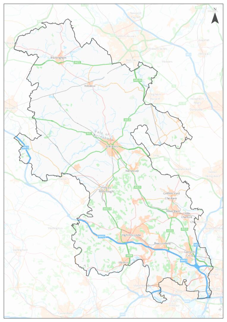
3.3 The PPG states that the geographical extent of site selection and assessment should be the plan-making area.[5] The geographical area for the HELAA now covers the whole of the Buckinghamshire Council area (i.e. plan-making area). Figure 2 shows the geographical area for the Buckinghamshire HELAA.
Figure 2: Buckinghamshire Council Administrative Boundary
Land Uses
3.4 For the purpose of undertaking the Buckinghamshire HELAA, the methodology will focus on housing and economic land uses. This is in line with the PPG which provides guidance on assessing land availability for housing and economic uses. Housing will be defined as development falling within Use Class C3 (residential dwellings). Economic development uses is defined in the PPG as retail, leisure, cultural, office, warehousing, etc.
3.5 On 1 September 2020, the Use Classes Order 1987 was significantly amended, which introduces a new Class E (commercial, business and service); Class F.1 (learning and non-residential institutions); and Class F.2 (local community). The previous Class B1 use now falls within Class E however Classes B2 and B8 remain unchanged.
3.6 The HELAA will consider economic development uses that falls within Classes B2, B8 and E. Additional types of uses will also be considered such as the travelling communities.
Size Thresholds
3.7 The PPG sets out that a HELAA should consider all sites capable of delivering 5 or more dwellings or economic development on sites of 0.25 hectares (or 500 square metres of floor space) and above.[6] The methodology will adopt the size thresholds as set out in the PPG. Sites of less than 5 dwellings will be considered as windfall.
Desktop identification of sites and broad locations
3.8 The PPG states that when carrying out desktop review, plan-makers need to be proactive in identifying as wide a range of sites and broad locations for development as possible. It is important that plan-makers do not simply rely on sites that they have been informed about, but actively identify sites through the desktop review process that may assist in meeting the development needs of an area.[7]
3.9 Table 1 sets out the minimum data sources that Buckinghamshire Council will use for the desktop identification of sites and broad locations.
Table 1: Data sources for desktop identification of sites and broad locations
Data Sources
Explanation
Existing housing and economic development allocations not yet with planning permission
Local and neighbourhood plans
Planning applications records
Planning Permissions for housing and economic development that are unimplemented or under construction
Planning application records
Development starts and completions records
Planning applications that have been refused or withdrawn
Planning application records
Land in the local authority's ownership
Local authority records
Surplus and likely to become surplus public sector land
National register of public sector land Engagement with strategic plans of other public sector bodies such as central government, National Health Service, police, fire services, utilities services, statutory undertakers
Sites with permission in principle, and identified brownfield land
Brownfield land registers (parts 1 and 2)
Vacant and derelict land and buildings (including empty homes, redundant and disused agricultural buildings, potential permitted development changes, e.g. offices to residential)
Local authority empty property register
Commercial property databases (e.g. estate agents and property agents)
Brownfield land registers
Additional opportunities for unestablished uses (e.g. making productive use of under-utilised facilities such as garage blocks)
Ordnance Survey maps
Aerial photography
Planning applications
Site surveys
Discussions with internal stakeholders
Business requirements and aspirations
Enquiries received by local planning authority
Active engagement with sector
Sites in rural locations
Large scale redevelopment and redesign of existing residential or economic areas
Sites in adjoining villages and rural exceptions sites
Potential urban extensions and new free-standing settlements
Local and neighbourhood plans
Planning applications
Ordnance Survey maps
Aerial photography
Site surveys
Planning Policy evidence base
Sites considered through previous HELAAs
Sites identified as having development potential in Employment Land Reviews or other evidence base studies
Call for Sites
Call for sites and broad locations
3.10 In addition to a desktop review, a call for sites and broad locations exercise can also enable people to promote sites for consideration and assessment. This may be undertaken for a fixed period of time or on an ongoing basis. In accordance with the PPG, the call for sites and broad locations will be aimed at as wide an audience as is practicable so that those not normally involved in property development have the opportunity to contribute.[8]
3.11 The call for sites and broad locations may identify land that was not identified through the desktop review. It may also provide more up-to-date or detailed information about land identified through the desktop review.
3.12 A call for brownfield sites was held between 16 February and 6 April 2021, which resulted in a total of 266 sites received, however not all of these sites were brownfield. An ongoing call for brownfield sites was launched on 6 December 2021 with a dedicated webpage being made available on the Council's website. This is to ensure that all brownfield sites are considered first before exploring other sites. There is a separate wider call for sites that will run from June to September 2022. The sites received will be considered in a HELAA, however subject to the stage of the HELAA preparation, there will be some sites that will be considered in a future HELAA update.
3.13 An example of a call for sites and broad locations submission form can be seen at Appendix 1.
Sites and broad locations with overlapping boundaries
3.14 There is potential for duplication and overlapping boundaries when identifying sites and broad locations from the varying types of data sources. Where there is duplication of a site or broad location with identical boundaries, the site or broad location will only be assessed once within a HELAA.
3.15 Where site or broad location boundaries overlap, the first action will be to explore the reason for this overlap. This can be done by considering the source(s) of the sites/broad locations in the first instance. In the situation that a more recent submission or data source clearly supersedes an earlier submission or data source, the more recent boundary will be used. In the situation that two or more distinct sites or broad locations overlap, they will be assessed together as a whole, with commentary provided on the suitability, availability and achievability of individual parcels.
Initial site and broad location survey
3.16 The sites and broad locations identified through the desktop review and call for sites and broad locations will be added to the GIS mapping system and an initial survey will be undertaken.
3.17 The purpose of the initial survey is to establish up-to-date, high level information on each site and broad location in relation to its character and key constraints. This will help to understand the type and scale of development that may be appropriate and to gain a more detailed understanding of deliverability, including any barriers and how they could be overcome.[9]
3.18 Information on the sites and broad locations will be collected as part of the initial survey stage. Table 2 sets out the minimum information to be collected.
Table 2: Initial survey information to be collected
Type of Information
Explanation
Site size, boundaries and location
Name
Site/broad location name
Size
Area size in hectares
Parish
Name of parish that the site/broad location falls within
Legacy Area
Legacy area that the site/broad location falls within
Current land use and character
Land type
High level description based on the majority of the area (e.g. greenfield/brownfield)
Current land use
High level description of current land use(s)
Land uses and character of surrounding area
Surrounding land uses and character
High level description of surrounding land uses and character (e.g. urban/rural character)
Physical constraints
Access
High level description of any physical constraints in terms of vehicular, cycle or pedestrian access
Contamination
High level description of any known land contamination constraints
Flood risk
High level description based on the majority of the site/broad location. Use fluvial flood risk zones.
Infrastructure/utilities
High level description of any known physical constraints such as pylons, overhead power lines, substations, transmission pipelines and their safeguarded area, and water/wastewater infrastructure
Topography
High level description of any known constraints relating to elevations or slopes
Potential environmental constraints
Area of Outstanding Natural Beauty (AONB)
Note if the site/broad location is within AONB.
Scheduled Ancient Monuments (SAM) and Ancient Woodlands
Note if there is a SAM or Ancient Woodland within or adjacent to the site/broad location.
Site of Special Scientific Interest (SSSI)
Note if there is a SSSI within or adjacent to the site/broad location.
Special Areas of Conservation (SAC)
Note if there is a SAC within or adjacent to the site/broad location.
Special Protection Area (SPA)
Note if there is a SPA within or adjacent to the site/broad location.
Consistency with development plan policies
Allocation
Note if the site/broad location is subject to an allocation in an adopted local plan, minerals and waste plan or made neighbourhood plan.
Designated Local Green Space (LGS)
Note if there is a LGS within or adjacent to the site/broad location.
Green Belt
Note if the site/broad location is within Green Belt.
Proximity to services and infrastructure
Access to services and facilities including public transport
High level description of access to services and facilities including public transport services.
Potential type of development
Source of site
Note how the site/broad location was identified for inclusion in the HELAA.
Submitted/promoted use
Note submitted/proposed use as per call for sites and broad locations or planning application submissions.
Initial sift of sites and broad locations
3.19 The PPG states that there may be some sites and broad locations which, when taking into account national policy and designations, will not be appropriate to carry out more detailed assessments as it is clear that they will not be suitable for development.[10] Therefore significant constraints and criteria should be considered at this stage where they will affect the assessment of sites and broad locations. This is to ensure that the sites and broad locations are appropriately assessed before the detailed assessment stage.
3.20 Table 3 sets out the constraints and criteria used to exclude sites and broad locations from the detailed assessment stage.
Table 3: Constraints/criteria for excluding sites/broad locations
Constraints/Criteria
Explanation
Sites and broad locations for less than 5 dwellings or under 0.25 hectares (or 500 square metres of floor space) for economic development
Sites to be excluded as they do not meet the size threshold set out in the PPG. Sites of less than 5 dwellings will be included as part of the windfall assessment for housing.
Ongoing employment sites that are not recommended for release
Sites to be excluded if evidence recommend that it should remain in employment use for meeting identified need.
Sites within the Green Belt which are not on Previously Developed Land
Greenfield sites within the Green Belt to be excluded. The NPPF identifies these sites should only be developed in very special circumstances.
Planning status
Sites to be excluded if a permitted development covering the whole area has been completed, or if it has commenced and there is no further development potential.
Flood risk
Sites to be excluded for residential development if majority of the area falls within Flood Zone 3.
Site of Special Scientific Interest (SSSI)
Sites to be excluded if a SSSI covers the entire area. If the designation only covers part of the site, a judgement will be made based upon the sensitivities of the designation and likely impacts of development.
Special Areas of Conservation (SAC)
Sites to be excluded if a SAC covers the entire area. If the designation only covers part of the site, a judgement will be made based upon the sensitivities of the designation and likely impacts of development.
Special Protection Area (SPA)
Sites to be excluded if a SPA covers the entire area. If the designation only covers part of the site, a judgement will be made based upon the sensitivities of the designation and likely impacts of development.
Scheduled Ancient Monuments (SAM) and Ancient Woodlands
Sites to be excluded if a SAM or Ancient Woodland covers the entire area. If the designation only covers part of the site, a judgement will be made based upon the sensitivities of the designation and likely impacts of development.
Designated Local Green Space (LGS)
Sites to be excluded if a LGS covers the entire area. If the designation only covers part of the site, a judgement will be made based upon the sensitivities of the designation and likely impacts of development.
Stage 2: Site and broad location assessment
Estimating development potential
3.21 The PPG states that the estimation of the development potential of a site or broad location can be guided by existing or emerging plan policy including locally determined policies on density. Plan makers should seek to make the most efficient use of land in line with policies set out in the NPPF.[11] This should also take into consideration of viability, given the quantum may affect viability and therefore, achievability and so inform developability within five years or beyond.
3.22 The development potential of the sites and broad locations will be assessed on a case-by-case basis. The housing potential is indicative only and does not prejudice assessments made through the Local Plan or planning application process. Given the diverse built character of places across Buckinghamshire, the housing densities will take into account the following factors:
- Adopted planning policy
- Emerging planning policy
- Existing/emerging evidence studies
- Recent planning history
- Constraints
- Location and accessibility
- Surrounding character and density
- Infrastructure requirements
3.23 The developable area of the site/broad location will also need to be identified based on the constraints listed in Table 3. The developable area and the development potential at this stage remain indicative for the purposes of the HELAA. It will be for the Local Plan process to identify how relevant constraints could be addressed through appropriate mitigation, including the assessment of sites through the Sustainability Appraisal and allocation of sites in the Local Plan and other associated Development Plan Documents. It could also be tested thoroughly through the development management process.
3.24 For gypsy and traveller sites, the size and layout of existing traveller sites will be considered, as well as the Government's Good Practice Guide: Designing Gypsy and Traveller Sites (May 2008). Although the Good Practice Guide is dated and has been withdrawn, it does include useful design principles which are still relevant.
Suitability
3.25 The PPG[12] states that a site or broad location can be considered suitable if it would provide an appropriate location for development when considered against relevant constraints and their potential to be mitigated. When considering constraints plan-makers may wish to consider the information collected as part of the initial site survey, as well as other relevant information such as:
- national policy;
- appropriateness and likely market attractiveness for the type of development proposed;
- contribution to regeneration priority areas;
- potential impacts including effect upon landscapes including landscape features, nature and heritage conservation.
3.26 Sites/broad locations already allocated in the development plan or with planning permission will generally be considered suitable for development, and have therefore not been considered further in this assessment, which focuses on new sites/broad locations for future delivery. Some sites with planning permission may be reviewed if circumstances have changed which reflects the guidance in the PPG.
Availability
3.27 The PPG states that a site or broad location can be considered available for development, when, on the best information available (confirmed by the call for sites and information from land owners and legal searches where appropriate), there is confidence that there are no legal or ownership impediments to development.[13] Extant or expired planning permissions can also inform availability and will establish five year timeframes, or beyond, of developability.
Achievability
3.28 The PPG states that a site or broad location is considered achievable for development where there is a reasonable prospect that the particular type of development will be developed on the site at a particular point in time. This is essentially a judgement about the economic viability of a site, and the capacity of the developer to complete and let or sell the development over a certain period.[14]
3.29 Sites and broad locations that are identified as not being suitable and available for development will not be considered achievable. Sites and broad locations that are identified as being suitable for development but not available may not be deliverable within the first five years but may be identified as being achievable later in the plan period.
3.30 The timescale for the development potential and rate of development could be identified when considering the size, scale and quantum of development, which in turn should take into consideration lead-in times and build-out rates. Information from the site submissions, developers and other third parties will help feed into timescales and development rates.
Stage 3: Windfall assessment
3.31 The term 'windfall sites' is defined in the NPPF as "Sites not specifically identified in the development plan."[15]
3.32 The PPG outlines that a windfall allowance may be justified in the anticipated supply if a local planning authority has compelling evidence as set out in Paragraph 71 of the NPPF.
"Where an allowance is to be made for windfall sites as part of anticipated supply, there should be compelling evidence that they will provide a reliable source of supply. Any allowance should be realistic having regard to the strategic housing land availability assessment, historic windfall delivery rates and expected future trends. Plans should consider the case for setting out policies to resist inappropriate development of residential gardens, for example where development would cause harm to the local area."[16]
3.33 The windfall allowance is specific to each legacy area and the local evidence base for each will be used to inform this work and decide the extent to which windfall development should be considered in the HELAA process. The evidence will be considered collectively to identify a Buckinghamshire wide windfall allowance.
3.34 The HELAA does not include sites which are less than 5 dwellings (net), therefore a windfall allowance will be included for smaller developments falling below the defined HELAA threshold of 5 dwellings. The annual windfall allowance will be determined by applying a trend-based approach based on an analysis of completions over a period of 10 years, which reflects the potential effect of the pandemic.
Stage 4: Assessment review
3.35 Once sites and broad locations have been assessed, an indicative trajectory will be produced setting out how much housing and economic development can be provided across the plan area and at what point in the future it could be delivered.
3.36 The trajectory will outline the forecasted delivery of development in three timeframes as set out in the PPG[17]: 0-5 years, 6-10 years and 11 years and beyond.
3.37 If a shortfall in supply to meet the needs of the plan area is identified, the assessment will need to be revisited, for example to carry out a further call for sites, or changing assumptions about the development potential of particular sites to ensure these make the most efficient use of land.[18]
3.38 If evidence shows that a shortfall in provision continues to exist the Council will consider continued cross-boundary provisions in accordance with the statutory Duty to Co-operate. This will enable the necessary Statements of Common Ground and other joint agreements to be formulated as Local Plan work progresses, helping to achieve a sound Local Plan.
Stage 5: Final evidence base
3.39 The HELAA will, as a minimum, include the following information in accordance with the PPG[19]:
- A list of all sites or broad locations considered, cross-referenced to their locations on maps;
- An assessment of each site or broad location including:
- Where these have been discounted, evidence justifying reasons given;
- Where these are considered suitable, available and achievable, the potential type and quantity of development, including a reasonable estimate of build out rates, setting out how any barriers to delivery could be overcome and when;
- An indicative trajectory of anticipated development based on the evidence available.
3.40 The assessments will be made publicly available in an accessible form.
3.41 The HELAA will be used alongside a suite of relevant technical reports and analysis, to inform the development strategy for the plan area and subsequently, to inform the site selection process and formation of policy criteria. It will also be used to inform five-year housing land supplies, and used as a starting point to identify available land for inclusion in Neighbourhood Plans and Brownfield Land Registers.
[4] Planning Practice Guidance: Housing and Economic Land Availability Assessment Paragraph: 005 Reference ID: 3-005-20190722
[5] Planning Practice Guidance: Housing and Economic Land Availability Assessment, Paragraph: 006 Reference ID: 3-006-20190722
[6] Planning Practice Guidance: Housing and Economic Land Availability Assessment, Paragraph: 009 Reference ID: 3-009-20190722
[7] Planning Practice Guidance: Housing and Economic Land Availability Assessment, Paragraph: 010 Reference ID: 3-010-20190722
[8] Planning Practice Guidance: Housing and Economic Land Availability Assessment, Paragraph: 012 Reference ID: 3-012-20190722
[9] Planning Practice Guidance: Housing and Economic Land Availability Assessment, Paragraph: 013 Reference ID: 3-013-20190722
[10] Planning Practice Guidance: Housing and Economic Land Availability Assessment, Paragraph: 014 Reference ID: 3-014-20190722
[11] Planning Practice Guidance: Housing and Economic Land Availability Assessment, Paragraph: 016 Reference ID: 3-016-20190722
[12] Planning Practice Guidance: Housing and Economic Land Availability Assessment, Paragraph: 018 Reference ID: 3-018-20190722
[13] Planning Practice Guidance: Housing and Economic Land Availability Assessment, Paragraph: 019 Reference ID: 3-019-20190722
[14] Planning Practice Guidance: Housing and Economic Land Availability Assessment, Paragraph: 020 Reference ID: 3-020-20190722
[15] National Planning Policy Framework (July 2021) Glossary
[16] National Planning Policy Framework (July 2021) Paragraph 71
[17] Planning Practice Guidance: Housing and Economic Land Availability Assessment, Paragraph: 024 Reference ID: 3-024-20190722
[18] Planning Practice Guidance: Housing and Economic Land Availability Assessment, Paragraph: 025 Reference ID: 3-025-20190722
[19] Planning Practice Guidance: Housing and Economic Land Availability Assessment, Paragraph: 026 Reference ID: 3-026-20190722


