Strategic Environmental Assessment (SEA) for the Shenley Park SPD
AECOM is commissioned to lead on Strategic Environmental Assessment (SEA) in support of the emerging Shenley Park Supplementary Planning Document (SPD).
Shenley Park, near Whaddon, is one of the allocated sites for growth within the former district of Aylesbury Vale, located at the edge of Milton Keynes. This site, together with other allocations within the adopted Vale of Aylesbury Local Plan 2011-2031 (VALP, adopted 2021), is required to fulfil the level of growth for Aylesbury Vale as set out in VALP Policy S2 Spatial Strategy for Growth.
The aim of the SPD is to build upon the statutory development plan (VALP and other SPDs), expanding upon the VALP site allocation policy (WHA001), with a view to guiding work at the planning application / development management stage and ultimately ensuring sustainable development. The scale of the site (99ha) and allocation (at least 1,150 homes) is such that an SPD is warranted. However, it is important to be clear that SPDs cannot change or add new policy (see guidance).
SEA is a mechanism for considering and communicating the likely effects of an emerging plan, and alternatives, with a view to minimising negative effects and maximising positive effects. Central to the SEA process is publication of an Environmental Report for consultation alongside the Draft Plan that essentially presents an assessment of "the plan and reasonable alternatives".
This Environmental Report / NTS
At the current time the Draft Shenley Park SPD is published for consultation and the Environmental Report is published alongside, in order to inform the consultation. This is the Non-Technical Summary (NTS) of the Environmental Report.
Both the Environmental Report and this NTS sets out to answer three questions:
- What has plan-making / SEA involved up to this point?
- including in relation to 'reasonable alternatives'.
- What are the SEA findings at this stage?
- i.e. in relation to the Draft Plan.
- What happens next
Firstly, there is a need to set the scene by answering: What's the scope of the SEA?
The scope of the SEA is reflected in a list of topics and objectives, which, taken together indicate the parameters of the SEA and provide a methodological 'framework' for assessment. The following topics form the core of the framework:
- Biodiversity
- Climate change
- Communities, health and wellbeing
- Historic environment
- Landscape
- Land and water resources
- Transport
Plan making/SEA up to this point
An important element of the required SEA process involves assessing reasonable alternatives in time to inform development of the Draft Plan, and then publishing assessment findings in the Environmental Report to be benefit of consultees. As such, Part 1 of this report explains how work was undertaken to develop and assess a 'reasonable' range of concept masterplan alternatives.
Work on concept masterplan alternatives has been undertaken over a period around one year and has involved extensive engagement with stakeholder organisations as well as a range of technical evidence gathering workstreams. The 'design evolution' is explained in detail within a report available at the current time entitled Shenley Park SPD Baseline Evidence and Design Analysis (DLA, June 2023).
The report considers a wide range of issues and options before concluding that the key choice, at the current time, is in respect of "access + movement" – see Figure A. For other masterplanning issues the report concludes that there is a clear preferred approach at the current time (i.e. for consultation), in light of the available evidence.
However, for the purposes of this Environmental Report, it is considered appropriate to 'take a step back' and consider more high-level concept masterplan alternatives – see Figure B. Whilst there is a clear argument in support of Option 1, which forms the basis for DLA 'access + movement' scenarios', on balance it is considered reasonable to explore the four concept masterplan alternatives in detail here.
The reasonable concept masterplan alternatives are defined with a view to enabling particular consideration of / discussion around the following key issues:
- Archaeology – extensive work has been undertaken to consider a key archaeological constraint affecting the central-eastern part of the site, namely evidence of a Roman settlement. This culminated in a Cultural Heritage Impact Assessment (CHIA, Oxford Archaeology, 2023) which confirmed that the settlement is of local significance and, in turn, recommended that it does not necessitate preservation in situ (i.e. it can be excavated, recorded etc). However, in order to further bolster the evidence-base behind this approach, it is considered necessary to test the option of avoiding development over the archaeological site.
- Southern half of the site – Shenley Park is "a site of two halves", with fewer constraints to development in the northern half (a plateau) relative to the southern half (a valley). There are clear arguments in favour of at least some development in the southern half, including mindful of the road connectivity, with the VALP policy requiring a new link road passing from the A421 (at the southern edge of the site) northeast through the site to join the MK grid road network (H6 and/or H7); however, there is also feasibly the option of nil growth. The assumed implication is a need for commensurately higher growth in the north (see below).
- Green infrastructure – numerous elements of the green infrastructure strategy are now very well established (or even a 'given'); however, a key matter potentially remaining open to consideration is in respect of the size of the landscape / greenspace buffer between the site and the historic hilltop village of Whaddon.
Finally, all options are assumed to deliver at least 1,150 homes in line with VALP Policy WHA001, and mindful of the importance of delivering on the committed VALP land supply. Further context is that the site promoter submitted an EIA Scoping Report for up to 1,650 home scheme in 2022, although the latest developer proposal is for a 1,265 home scheme (see shenleypark.consultationonline.co.uk).
Figure A: Tightly bounded concept masterplan alternatives varying only in respect of approach to 'access and movement', as defined within the DLA Study (June 2023)
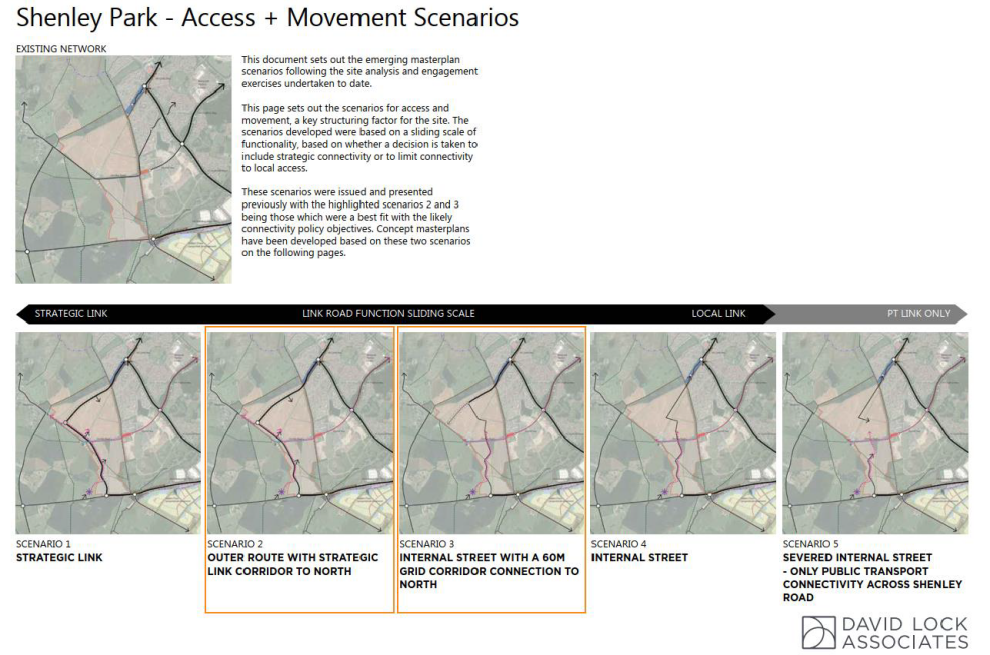
Figure B: The high-level concept masterplan 'reasonable alternatives'
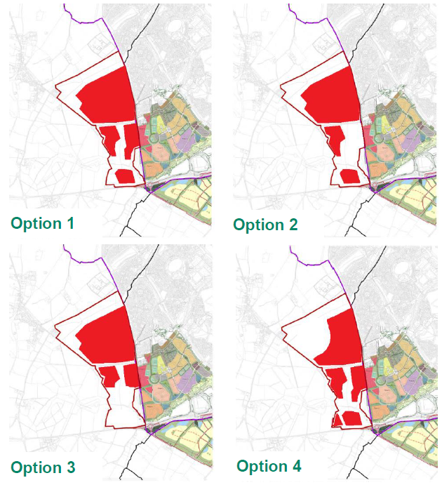
Table A presents an assessment of the high-level concept masterplan alternatives introduced above (Figure B). Presented subsequently is Buckinghamshire Council's response to the assessment / explanation of the preferred approach.
With regards to assessment methodology:
Within each row (i.e. for each of the topics that comprise the SEA framework) the columns to the right hand firstly rank the alternatives in order of preference and then, secondly, highlight instances of a predicted significant positive effects (green), moderate or uncertain positive effects (light green), moderate or uncertain negative effects (amber) and significant negative effects (red) significant effect on the baseline (mindful of established objectives). Also, '=' is used where it is not possible to confidently differentiate between the alternatives.
Table A: Reasonable alternatives assessment findings
|
Topic |
Option 1 Emerging preferred option |
Option 2 Archaeology in situ |
Option 3 Avoid the south |
Option 4 Whaddon buffer |
|
Rank (number) and significant effects (shading) |
||||
|
Biodiversity |
2 |
3 |
|
3 |
|
Climate change |
 |
2 |
2 |
2 |
|
Communities |
|
2 |
2 |
|
|
Historic env |
= |
= |
= |
= |
|
Landscape |
2 |
3 |
|
3 |
|
Land and water |
= |
= |
= |
= |
|
Transport |
|
2 |
2 |
2 |
The assessment shows a mixed picture, with each option associated with a degree of relative merit. Option 1 performs well in a number of respects; however, it is important to be clear that it is not for SEA to arrive at an overall conclusion on which of the options is 'best'. That is because SEA is undertaken without any assumptions made in respect of the degree of importance, or 'weight', that should be assigned to each of the topics that make up the SEA framework. It is for the plan-maker to assign weight and then decide which option is preferred on balance.
Having made these initial points, the following bullets consider each topic in turn:
- Biodiversity – the key consideration here is Whaddon Chase, which is a collection of woodlands associated with a former royal hunting forest. Key components of Whaddon Chase surround the southern part of the site. Also, within the southern part of the site is the Tattenhoe Brook corridor along with several linked areas of woodland that likely contribute to ecological functioning within the Whaddon Chase landscape (a Biodiversity Opportunity Area).
On the face of things, the Whaddon Chase constraint / opportunity might serve to indicate a preference for Option 3, which would avoid development in the sensitive southern part of the site. However, under this scenario there would still need to be a road corridor through the southern parcel, and the landowner might well still continue to promote the southern parcel for development, as opposed to making the land available for green infrastructure in perpetuity.
With regards to Options 2 and 4, there is limited biodiversity argument for a new area of parkland over the archaeological site (Option 2) or larger landscape gap to Whaddon (Option 4) at the expense of increased housing delivery in the southwest of the site, including in proximity to Whaddon Chase woodlands.
In conclusion, it is fair to highlight Option 3 as having a degree of merit in theory; however, in practice, and with a long-term perspective, this is less clear. Option 1 also performs well given that this approach to broad layout within the site has formed the basis for recent work to consider link road options (see Figure A above, also discussion below) as part of a wider effort to ensure that the SPD is suitably 'future-proofed', including mindful of long-term strategic planning for Whaddon Chase, including the possibility of woodland creation (see Appendix 9 of the DLA Evidence Study, also Section 9 of the main report).
- Climate change – beginning with the matter of climate change adaptation / resilience, flood risk is typically a primary consideration, and this is the case for Shenley Park, where a small brook passes through the southern half of the site. There might be a theoretical argument in support of Option 3, with a view to extensively buffering the river corridor; however, in practice, and with a long-term perspective, it is not clear that this is the case, for the reasons discussed above, under 'Biodiversity. The assumption under all of the alternatives is that the brook would be integrated within an extended Tattenhoe Valley Park.
Moving onto climate change mitigation / decarbonisation, the primary consideration is minimising per capita greenhouse gas emissions from transport, which primarily means minimising the need to travel and supporting a modal shift away from the private car towards public and active transport.
In this respect, key considerations are: A) all options can deliver a new public transport route through H7 (with a link to the local centre); B) Option 2 would not align well with a desire to make best use of Shenley Road as an active travel route, nor weight growth in proximity to the MK-edge (particularly the nearby Westcroft District Centre); and C) Option 1 has formed the basis for detailed work to consider link road options (as discussed above), including work around future-proofing for a possible Mass Rapid Transit system for MK and/or a Park and Ride to the SW of the City (potentially west of the Bottledump roundabout).
Finally, with regards to the objective of minimising per capita greenhouse gas emissions from the built environment, the scale of Shenley Park gives rise to a theoretical opportunity, as does the potential to support fairly high-density development and a mix of uses in the northern half of the site (i.e. housing alongside a community centre). Specifically, there could be an opportunity in respect of achieving a standard of regulated operational emissions that exceeds the requirements of Building Regulations, and feasibly even achievement of net zero emissions (ideally without offsetting, i.e. 'onsite net zero'). Also, there might be an opportunity in respect of non-operational emissions, which are unregulated, e.g. embodied carbon in building materials.
In this light, a consideration is whether any of the alternatives would necessitate a higher density local centre / higher density scheme in the northern half of the site; however, it is not clear that this is a significant consideration.
Another consideration is development viability, with a need to ensure that funding is available for decarbonisation / net zero focused measures. There is a viability argument for supporting growth across the site (Option 1), including within the southern area where new homes would need to be lower density (reflecting the sensitivities) and hence would have strong viability credentials. Furthermore, in the absence of support for new homes in the southern part of the site there could well continue to be pressure for growth here in the future, leading to a risk of 'piecemeal' growth with opportunities missed for securing developer contributions and investment in zero carbon focused measures.
In conclusion, Option 1 is supported from a perspective of both transport and built environment decarbonisation and does not give rise to any significant concerns from an adaptation perspective. Under Option 1 the effect of the SPD would certainly be to secure an improvement on the baseline, but it is not clear that this benefit would be 'significant' in the context of a climate emergency.
- Communities, health and wellbeing – focusing on Option 4, this would see a much larger landscape gap to Whaddon, which is a historic and by all accounts thriving village community. However, there is a clear argument for a buffer that is 'the right size' in terms of both ensuring separation and enabling good integration between the communities either side. In this light, there is thought to be a widespread understanding that, whilst the Whaddon buffer must be of a good size, what is of equal or similar importance is that it is of a high quality, including via investment in landscaping and measures to support active use.
Also, under Option 4 the effect would also be that a major emphasis of open space delivery within the site would be at the northwest extent, with a very strong concentration in this one area, potentially at the expense of open space elsewhere within the site (in terms of land availability and potentially also investment), including locations accessible from the existing MK edge. In this respect Option 2 potentially has a degree of merit, as there would be a new strategic open space adjacent to the current MK edge. However, in practice, it is not clear that there is a particular need for this (albeit it could be high quality including with measures around archaeological interpretation). The primary green infrastructure opportunity is around the Tatternhoe Valley Park extension.
Finally, under Option 4, there is a need to consider possible issues around road and public transport connectivity, including from a future-proofing perspective, and mindful of the importance of avoiding problematic levels of traffic through Shenley Park (with resulting 'communities' impacts).
In conclusion, it is fair to highlight theoretical support for Option 4, mindful of the views of Whaddon Parish Council around ensuring a good-sized landscape buffer. However, it is important to recognise potential drawbacks / challenges. - Historic environment – as discussed, the archaeological constraint affecting the central eastern part of the site (a Roman settlement, associated with the Shenley Road, which was a minor Roman road) was a key focus of discussion and technical work over the period 2022 to 2023. This culminated in a CHIA (2023) recommending that it is not necessary to preserve the site in situ, as it is of only local significance. Also, there is a need to consider the benefits of excavation (in terms of research etc), and also an understanding that the remains could be at risk of damage under a baseline scenario involving continued agricultural use of the land. In this light, it would not be appropriate to conclude a preference for Option 2, mindful of knock on implications for planning within the other land parcels within Shenley Park as well as, feasibly, implications for futureproofing, terms of strategic planning for the Whaddon area, Bottlehouse Farm (locally significant) and the Whaddon Chase landscape.
In conclusion, it is not possible to differentiate between the alternatives with any certainty. With regards to significant effects, neutral effects are predicted; however, there is an argument for predicting positive effects on the baseline, which is a 'no SPD' scenario. There is an urgent need for the SPD to be in place so that it can inform and guide the forthcoming planning application.
- Landscape – there is a clear theoretical argument in support of Option 3. However, in practice, and with a long-term perspective, this theoretical argument can be questioned, as has been discussed. It is crucially important that the SPD supports comprehensive and future-proofed growth, as opposed to risking piecemeal growth, which might even be described as 'sprawl'. It is hard to imagine the southern part of Shenley Park being left undeveloped in the long term and, in this light, there is a need to ensure a strategic approach is taken to sympathetic development, potentially to include strategic infrastructure, within what is a sensitive landscape including Tattenhoe Brook and Whaddon Chase.
Under Option 1 there would be the potential for lower density and high-quality housing growth in the southern part of the site. For example, the DLA Report (2023) discusses "opportunities for development running along, not across, the contours, using the south facing slopes and the linear park as key design influences, resulting in more varied and bespoke design responses..."
In conclusion, it is fair to highlight theoretical support for Option 3; however, in practice, there is an argument to suggest that Option 1 could be preferable. With regards to significant effects, there is a need to recall that there are no nationally designated landscapes in the area, albeit there is a case for 'larger-than-local' significance in the context of committed and possible further strategic growth elsewhere to the south / southwest of MK.
- Land and water – the majority of the site has been surveyed in detail and found to comprise land that is not of 'best and most versatile' (BMV) quality, as defined by the NPPF. Specifically, the land is of Grade 3b quality, whilst the NPPF defines BMV as land that is of Grade 1, 2 or 3a quality. In this light, there is limited argument for leaving the southern part of the site undeveloped and in continued use of agriculture, given that the effect could be to increase pressure for growth at locations elsewhere associated with higher quality land. There are some parts of the MK-edge known to be associated with Grade 2 quality land.
With regards to water, the only matter for consideration (recalling the scope of the SPD) is water quality within the brook that bisects the southern part of the site. However, there is no reason to suggest a particular concern, or any particular opportunity, under any of the reasonable alternatives. It is fair to assume high quality Sustainable Drainage Systems (SuDS) under all scenarios.In conclusion, the alternatives perform on a par with neutral effects predicted.
- Transport – this is a key issue, and one that has already been explored above. Detailed work has been undertaken to explore options for road connectivity (see Figure A), with this work assuming a broad approach in line with Option 1. This preferred approach involves an inner 'street', but also land reserved for a new strategic link / grid road. A final decision on the most appropriate approach will need to be made in light of future transport modelling. Also, there may be a need to account for proposals in the early stages of development for a Mass Rapid Transit system for MK and/or the potential for a Park and Ride to the SW of the City (which may be sited to the west of the Bottledump roundabout).
It is difficult to conclude with certainty that options other than Option 1 would conflict with strategic transport objectives, including from a future-proofing perspective. However, issues could arise, for example under: Option 4, including due to pressure for housing growth at the southwest extent of the site; and Option 3, where there would be a need for a new road link – strategic or otherwise – through the southern parcel without housing growth alongside.
Aside from the configuration of road / public transport links within the site and the wider area, the other key consideration is active travel links to key destinations including Westcroft District Centre, Salden Chase (where there is an approved reserve site for a new secondary school) and Central MK. Matters have already been discussed above, under the 'Climate change' heading.
In conclusion, Option 1 preferred and differential effects are judged to be of some significance, albeit there is uncertainty ahead of further work. There is a need to recall the baseline ('no SPD') situation, which could involve pressure for higher growth within the site without suitably strategic infrastructure planning.
The Shenley Park team at Buckinghamshire Council responded to the assessment as follows (N.B. the following text does not comprise an assessment):
"Option 1 is supported on balance, in light of the assessment. It performs well in a number of respects, although it is recognised that the assessment serves to highlight certain arguments for an alternative approach.
Option 1 best balances the objectives while supporting a policy compliant scheme. It seeks to ensure sufficient land is within the developable area of the site to deliver at least 1,150 homes and the other policy requirements of the site. It supports a landscape led approach with a clear western edge defensible boundary, recognises and responds to the 'on the ground' constraints of the site, including the more sensitive and topographically complex southern half, the archaeological remains, the trees and hedges and the existing communities.
Development on the southern part of the site allows the site to deliver on its policy objectives including the provision of a link road. Furthermore, the CHIA indicates that development is possible on the parcel containing the Roman settlement. The evidence shows that a larger buffer between Whaddon and Shenley Park is not necessary to provide appropriate separation, furthermore a larger buffer here would make the new facilities at Shenley Park less accessible to the residents of Whaddon and would put pressure on the more sensitive southern part of the site to accommodate more development."
Assessment findings at this stage
Part 2 of this report presents an assessment of the Draft SPD as a whole. In practice the assessment builds upon the assessment of Option 1 presented above.
Assessment findings are presented as a series of narratives under the SEA framework. The assessment concludes:
- Moderate or uncertain positive effects in respect of 'Transport'. There is an argument for predicting 'significant' positive effects, but there remains some uncertainty regarding implications of the SPD for strategic transport objectives for the A421 corridor / southwest MK area. Further transport modelling work and A421-related evidence is required ahead of a decision on a new link road.
- Moderate or uncertain positive under the 'Communities, health and wellbeing' heading. There is a carefully considered approach to creating a high-quality new community, ensuring good access to key services and facilities as well as green infrastructure, and careful consideration is also being given to the existing community at Whaddon. There remains a degree of uncertainty around the communities implications of a potential future strategic outer link / grid road, but the SPD has sought to accommodate these considerations as far as possible. Transport modelling that will support the planning application will inform a decision on the road requirements.
- Broadly neutral effects are predicted under other headings, as per the conclusion reached for concept masterplan Option 1. As is inevitably the case, there are a range of tensions with sustainability objectives, but there is a need to recall that the baseline situation is one whereby a planning application will be forthcoming in the absence of an SPD. On the matter of climate change mitigation, it is noted that a number of similar SPDs nationally require net zero development; however, in the Shenley Park context it is not clear that there is potential to set this requirement, recalling that SPDs cannot change or introduce policy.
Next steps
This Environmental Report is published for consultation Draft SPD. Subsequent to the consultation the intention is to finalise the SPD in light of consultation responses received. The next step will then be to formally adopt the SPD.


