Strategic Environmental Assessment (SEA) for the Shenley Park SPD
2. What is the SPD seeking to achieve?
Overview
2.1 Once adopted, the SPD will set out a clear framework and principles of what is expected from the development at the site-wide level, with flexibility to ensure detailed approaches are established through the planning application process.
N.B. with regards to the planning application process, an outline application is expected soon; see shenleypark.consultationonline.co.uk/the-site/next-steps.
2.2 More specifically, the SPD will identify in-principle support for a specific spatial disposition of land uses and infrastructure within the site that accords with VALP policy WHA001 along with a series of overarching design parameters to ensure a high quality, distinctive, sustainable, and well-integrated development.
2.3 In short, whilst the Council's overarching vision and objective for the site is signposted in Policy WHA001, the purpose of the SPD is to translate that high level objective into a site specific and spatial vision and design concept.
2.4 The vision for Shenley Park set out in the VALP involves "… an exemplar development, of regional significance, which will be a great place to live, work and grow. Built to a high sustainable design and construction standards, the development will provide a balanced mix of facilities to ensure that it meets the needs and aspirations of new and existing residents."
The site
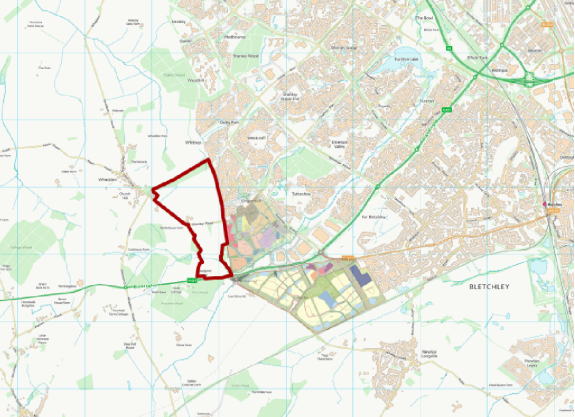
2.5 The site red line boundary can be seen in Figure 2.1, which also shows the Buckinghamshire / Milton Keynes (MK) boundary. The MK urban area is readily apparent, alongside the village of Whaddon to the west of the site. Adjacent to the south is the A421, a key artery that connects MK to the M40 corridor and other key locations to the west, with the Bottledump roundabout located at the southeast corner of the site. Shenley Road bisects the site and currently provides access between Whaddon and Milton Keynes, although the firm proposal is to downgrade the road to avoid traffic through Whaddon.
2.6 It is important to note that the MK urban area provides a wide variety of services, onward connections and amenities, with Central MK lying around 6.5km to the northeast, Bletchley Town Centre around 5.5km to the east and Westcroft District Centre around 1.5km to the northeast. Also, to the southeast of the site is a committed 1,855 home scheme called Salden Chase, which is set to deliver a new secondary school as well as employment land. Furthermore, Tattenhoe Park adjacent to the east of the site is under construction for 1,310 homes along with a range of community facilities. Figure 2.2 shows the location of these two committed schemes.
Supplementary information
2.7 A Baseline Evidence and Design Analysis Report (DLA, 2023) has been prepared to underpin the preparation of the SPD. It sets out key issues and opportunities, summarises the outcomes of engagement and technical work undertaken to date, details the key masterplanning and design considerations and presents the rationale for the preferred approach.
Figure 2.1: The site red line boundary, also showing woodlands in the area
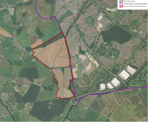
Figure 2.2: The site in the context of nearby committed strategic growth locations