Strategic Environmental Assessment (SEA) for the Shenley Park SPD
9. Assessment of the Draft SPD
Introduction
9.1 The assessment is presented as a series of narratives under the SEA framework. Each narrative leads to a conclusion on the Draft SPD as a whole.
Biodiversity
9.2 The assessment of concept masterplan reasonable alternatives presented in Section 6 broadly supports the preferred option. A key matter for discussion, as part of that appraisal, is around ensuring strategic, long-term consideration is given to Whaddon Chase woodlands.
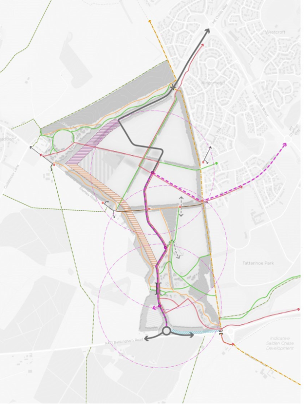
9.3 From Figures 9.1 and 9.2, which are taken from the Draft SPD, it can be seen that a carefully targeted approach is proposed in respect of green (and blue) infrastructure within the site. A key point to note is that the extension to Tattenhoe Valley Park will give rise to an opportunity for strategic habitat enhancement / creation, recognising that the Tattenhoe Brook, within the site, currently passes bisects a series of agricultural fields that have been under arable production in the recent past (according to historic satellite imagery).
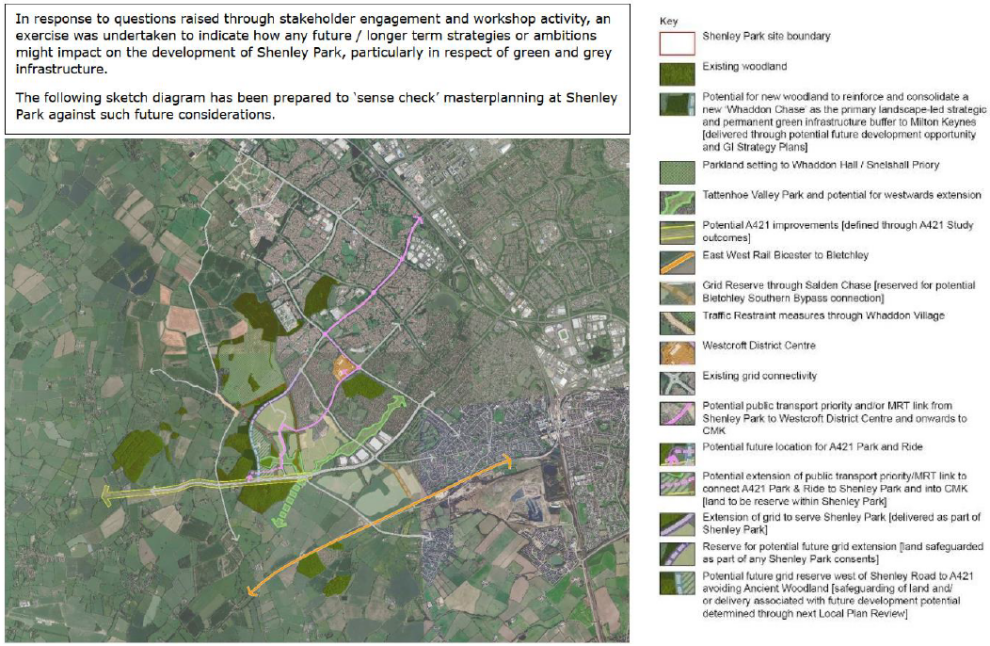
9.4 Another key point to note, from the two figures below, is that 'public open space' to adjacent to the southeast of the Whaddon buffer is reserved for a potential strategic grid road, which would then pass to the south, close-by to two of the Whaddon Chase component woodlands, before joining the A421. In turn, this could potentially lead to further housing development that, in turn, supports strategic woodland creation and/or a further expansion of Tattenhoe Valley Park, beyond Shenley Park as far as the small woodland patch to the west. The new grid road would have the effect of fragmenting habitat networks in the area to some extent, but there is overall support, from a biodiversity perspective, for taking a strategic approach to managing the expansion of MK with Whaddon Chase (and the Tattenhoe Brook corridor) firmly in mind. Figure 9.3 is taken from Appendix 9 of the DLA Evidence Study, which deals with 'future proofing'.
9.5 Geodiversity is another consideration, but no significant issues are known.
9.6 In conclusion, broadly neutral effects the baseline are predicted, accounting for established objectives. It is important to recall that the baseline ('no SPD') situation could see higher growth with less strategic coordination.
Figure 9.1: The preferred approach to green infrastructure (high level)
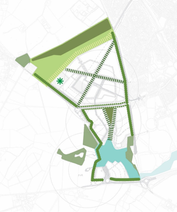
Figure 9.2: The preferred approach to green infrastructure (with added detail)
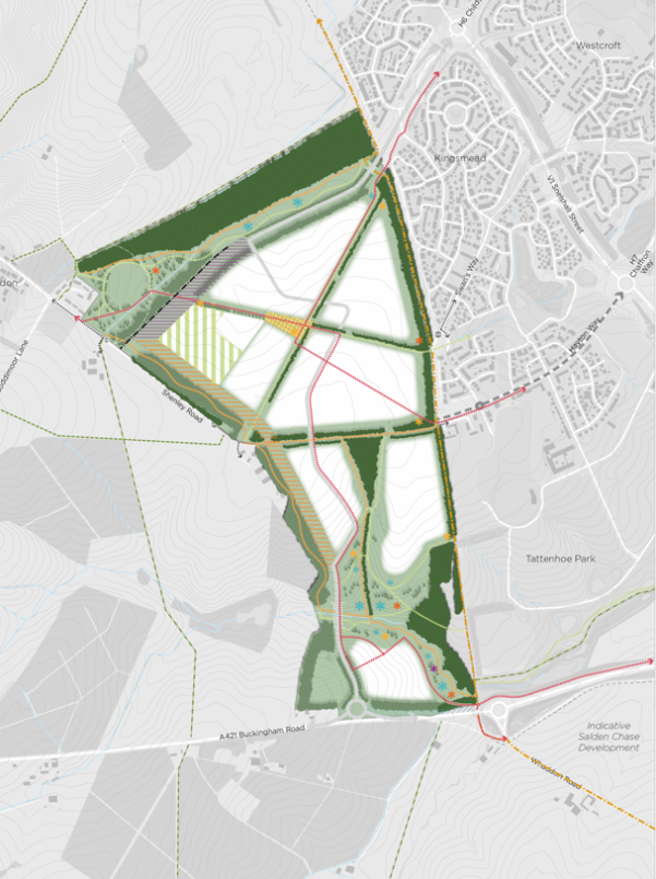
Figure 9.3: Long term future proofing considerations (DLA, 2023)
Climate change
9.7 The assessment of concept masterplan reasonable alternatives presented in Section 6 supports the preferred option, particularly from a perspective of seeking to minimise per capita greenhouse gas emissions from transport.
N.B. see further discussion under the 'Transport' heading below.
9.8 The assessment in Section 6 also gives consideration to built environment decarbonisation and climate change adaptation / resilience. However, it is difficult to suggest any significant issues or opportunities. It is noted that a number of similar SPDs nationally require net zero development; however, in the Shenley Park context it is not clear that there is potential to set this requirement, recalling that SPDs cannot change or introduce policy.
9.9 In conclusion, broadly neutral effects on the baseline are predicted, accounting for established objectives. The effect of the SPD would certainly be to secure an improvement on the baseline, but it is not clear that this benefit would be 'significant' in the context of a climate emergency.
Communities, health and wellbeing
9.10 The assessment of concept masterplan reasonable alternatives presented in Section 6 supports the preferred option.
9.11 There remains a degree of uncertainty around the communities implications of a potential future strategic outer link / grid road, but the SPD has sought to accommodate these considerations as far as possible in the absence of Transport Modelling evidence. One key point to note from Figures 9.1 and 9.2 is the proposal for a strong green infrastructure buffer along the western edge of the site. An outstanding question is in respect of land use the small parcel of land within the site to the west of the proposed new link road / street.
9.12 Aside from these high-level considerations, the Draft SPD proposes a range of detailed measures focused on the achievement of communities, health and wellbeing objectives. Beginning with the proposed vision, this states:
"The heart of the new community will be focused around a well-designed and human scaled local centre, with activities co-located to ensure short, linked trips can easily be made without using the car. Community facilities and services, including schools, shops and open spaces, will be provided in a timely manner alongside new homes to ensure that active travel habits within the site are established from the outset."
9.13 Detailed guidance is then provided on matters including:
- Local centre – for example: "The… local centre will be of a scale that provides sufficient goods, facilities and services to meet residents' day-to-day needs without creating competition with existing centres. Extensive walking and cycling connections extending across and through the site will create 'walkable neighbourhoods' meaning that the local centre will be easily accessed from all parts of the site, reducing the need to drive."
- Shenley Square – "… a central cluster of services around 'Shenley Square', with the potential to provide public realm with open space at its heart and a mix of uses including community facilities, foodstore/local retail and the policy-mandated care home. This will create a vibrant, local centre and annex 6 to the Baseline Report includes a series of precedent studies and best practice examples as design references for each of the components."
- Health facility – "Flexibility in the masterplanning of the local centre means that provision can be made on site for primary health care facilities if required. Further discussions with Buckinghamshire and Milton Keynes Integrated Care Boards would be required at the time of any application to confirm if this is required or the extent of off-site contribution required."
- Densities – "The use of varying intensities of development across the site could provide an increase in capacity of homes on the site and this would be appropriate in instances where densities can reinforce and support walkability within the neighbourhood and provide sufficient demand to promote sustainable travel options."
- Whaddon – "The northern neighbourhood of 'Briary Chase' will create a high quality transition between the Western Flank neighbourhoods and the village of Whaddon, enabling existing and new communities to interact harmoniously. Briary Park will create an extended parkland setting for the village of Whaddon, with homes to the south framing the new parkland…"
- Housing mix – "… will need to comply with the standards set out in VALP policies H6a/H6b (and respective supporting text)… A range of dwelling types and tenures will be provided for across the site, including a minimum of 25% affordable homes which will be 'pepper potted' across the site…"
- Primary school – "The new 2FE primary school and associated nursery, with opportunities for co-located sports pitches, are situated in an adjacent parcel to the west in close proximity to the proposed Shenley Square bus stop and with the main school building and entrance intended to be located where it can be easily accessible… The primary school should be open at the point in which admissions into reception year from the development reaches 15 pupils... This is estimated to be upon occupation of the 350th home or four years from the commencement of development…"
- Secondary school – "It is anticipated that offsite contributions will be secured (at timing trigger points to be agreed) for secondary school provision and to provide for any further primary school capacity which cannot be accommodated by the 2FE on-site school, taking into account capacity in the primary schools in the surrounding catchment areas."
- School playing fields – "… are shown provided adjacent to the school building but towards the outer edge of the northern parcel helping to retain the openness of the site towards the more sensitive countryside edges."
- MK Boundary Walk – "...an underpass to be constructed west of the current Boundary Walk... ensuring priority for uninterrupted walking/cycling/riding along this important public right of way."
9.14 It is also important to note sections presenting detailed guidance on 'Key Spaces and Places' and 'Bespoke Design Responses' .14
9.15 In conclusion, moderate or uncertain positive effects on the baseline are predicted, accounting for established objectives. The SPD is a key means of ensuring that the forthcoming planning application realises community, health and wellbeing objectives, albeit VALP policy also provides a good framework.
Historic environment
9.16 The assessment of concept masterplan reasonable alternatives presented in Section 6 broadly supports the preferred option. There is then a range of detailed guidance presented in the Draft SPD, for example:
- Urban form – "… will follow typical characteristics of nearby historic Buckinghamshire villages in the way they respond to their existing site levels and characteristics… As a general design principle, all development should seek to respond positively to and front edges where possible..."
- Scheduled monument – " Visual separation of Shenley Park from the Snelshall Priory Scheduled Ancient Monument will be maintained through the retention and enhancement of Briary Plantation Ancient Woodland and its protective buffer. The creation of a new link road connecting to H6 will be designed so as to minimise disturbance on the Ancient Woodland."
- Roman Settlement and archaeological remains – "Any excavation and recording of the Roman Settlement and other archaeological features present in and around the site will be reflected through the inclusion of interpretative boards at key locations as well as place signage. The archaeological and heritage assets within and around the site can also be used to inform the approach to and strategy for public art. Successful integration and interpretation can help instil a sense of ownership from the local community to the development and the nearby heritage assets and help create a distinctive development. This should be integrated into the layout for example as part of the play area design or local centre with consideration given to the long term management and maintenance.."
- Whaddon Hall – "Creation of an integrated and useable Whaddon buffer which is a sensitive extension to the parkland character to Whaddon Hall and which provides opportunities for informal recreation…"
N.B. by way of background, the SPD explain: "Whaddon Hall, a Grade II Listed building, overlooking the remains of Whaddon Chase, a former medieval hunting forest is also located to the north of the site." - Non-designated heritage assets (NDHAs) – the key issue is the collection of buildings at Bottlehouse House Farm. If a strategic outer link road were required (Scenario 1 and also potentially Scenario 2 in Figure 5.1) then farm outbuildings would be impacted. The SPD states that "if the 'outer link' is to come forward on this alignment, and is sufficiently justified, a level 3 recording of the buildings will be required."
9.17 In conclusion, broadly neutral effects on the baseline are predicted, accounting for established objectives. The effect of the SPD would certainly be to secure an improvement on the baseline, but it is not clear that this benefit would be 'significant' over-and-above the baseline situation involving a planning application coming forward under adopted VALP policy.
Landscape
9.18 The assessment of concept masterplan reasonable alternatives presented in Section 6 broadly supports the preferred option. The key issue is a need to take a balanced approach that recognises sensitivities to the south and also importance of a landscape buffer to Whaddon / Whaddon Park.
9.19 Aside from these high level considerations, the Draft SPD proposes a range of detailed measures focused on the achievement of landscape objectives.
9.20 Beginning with the proposed vision, it states:
"Taking a strong cue from its position within the wider Whaddon Chase landscape, a new community will be established at Shenley Park which blends effectively the best of 'town and country'."
9.21 There is then a range of detailed guidance presented in the Draft SPD, for example with a key distinction between:
- Northern 'Plateau' Neighbourhood – "… linear layout incorporating existing green infrastructure elements and orientated along lines of existing /enhanced hedgerows, with a higher density mixed use local centre at its heart, focusing public activity, community and education uses around high quality public realm / open spaces designed to foster a lively and welcoming sense of place. Development here could take its cues from more urban and contemporary styles of housing within Kingsmead and Tattenhoe Park in the west and in and around the local centre, transitioning to lower density and more rural edge typologies to the north-west…"
- Southern 'Valley' Neighbourhood – "… layout and character of buildings and public realm working with and heavily influenced by the topography. Predominantly residential, built development will run along, not across, the contours, using the south facing slopes, watercourse and the linear park as key design influences, resulting in more varied and bespoke design responses and housing styles (which could include self and custom build)"
9.22 Further detailed guidance is provided on matters including:
- Topography – "…starts with the premise that re-profiling, cut-and-fill, and engineering techniques will be minimised (if not avoided) and the Site's topography and resultant character will be preserved wherever possible to create a distinctive form of context driven development."
- Southern neighbourhood – "The layout and design… will clearly reflect the existing topography with streets and development arranged accordingly, resulting in a more intimate and informal character."
- Green infrastructure buffers – "Applying the landscape buffers stipulated by VALP policies NE2/NE8 to the existing on-site green / blue infrastructure – hedgerows (10m); woodland (25m); ancient woodland (50m) and watercourses (10m) – has been taken as a starting point…"
- Hedgerows and trees – "Existing green infrastructure of woodlands, trees and hedgerows will be retained in their entirety with the exception of one hedgerow which runs perpendicular to the A421."
- Whaddon Chase Biodiversity Opportunity Area (BOA) – "… design of landscape and green infrastructure will seek to protect, enhance, create and connect biodiversity to support coherent and resilient ecological networks as supported by Design Guidance."
- Whaddon Offset (Buffer) – "A 'Whaddon offset' of a minimum width of 150m between the extent of build development edges is required, providing a balance between visual separation and functional integration and community connectivity. The Whaddon offset will have a parkland character, with trees and grass / wildflower meadow being the predominant features… The open space will reflect the historic parkland character which exists immediately north of Briary Plantation...
… Leisure routes will be integrated into the design of the space and walking and cycling access and a connection to the MK redway network will be accommodated within this area providing connectivity between Whaddon, Shenley Park and MK. Bridleway access will be integrated providing connectivity eastwards towards the MK Boundary Walk and westwards towards Whaddon and the wider bridleway network."
- Outer Link reserve corridor – "Whilst not forming part of the 'Whaddon offset' the creation of the Outer Link reserve corridor and arrangement of playing fields / sports pitches will set-back built development within Shenley Park further from the southern extent of Whaddon village, further increasing the physical and visual separation between the two settlements."
- Western defensible edge – "A new defensible boundary to Milton Keynes will be created along the development's western edge using structural tree planting to be integrated with the site-wide green infrastructure.
…At a site level, the western boundary of the site is already well-defined on the ground by field boundaries and Shenley Road and can be reinforced with a combination of a well-designed development edge and landscape design. Substantial areas of tree planting will be created..."
… The design approach to landscape planting should reflect the 'plateau' characteristic of the northern part of the site and the 'valley' characteristic of the southern part. This will manifest in a consistent woodland block as edge treatment for the northern part (north of Shenley Road)... with a more flexible and organic width of woodland buffer along its length for the southern part of the site (south of Shenley Road to the A421)."
- Tattenhoe Valley Park extension – "… will connect Milton Keynes to the open countryside through the site… create a high-quality public space with integrated active travel routes (including bridleways), green infrastructure and naturalistic stormwater attenuation features, replicating these elements of the design ethos for the wider… park."
… Path connections will be made between the linear park and the adjacent streets and development parcels. Cross-park permeability will be provided… Lighting shall be limited to the Redways and primary paths with the linear park being generally a dark zone."
- SuDS – "will be considered as an integral component of the development at all scales from individual building / plot to the attenuation basin. SuDS will be sensitively integrated across the development to provide stormwater attenuation functionality in streets (through elements such as swales) and development areas (such as formal ponds) as well as open spaces."
9.23 In conclusion, broadly neutral effects on the baseline are predicted, accounting for established objectives. A carefully considered approach is proposed for this "site of two halves" also accounting for the need to future-proof. The effect of the SPD would certainly be to secure an improvement on the baseline, but it is not clear that this benefit would be 'significant'.
Land and water
9.24 The assessment of concept masterplan reasonable alternatives presented in Section 6 broadly supports the preferred option, and there is little further to add here in respect of the Draft SPD as a whole. With regards to surface water drainage, the Draft SPD states:
"The drainage design solutions developed must respond sensitively and appropriately to the existing Site (including topography, vegetation, water bodies) to ensure the SuDS features can provide a wide range of benefits additional to the functional drainage including amenity, recreation, biodiversity and placemaking."
9.25 In conclusion, broadly neutral effects on the baseline are predicted, accounting for established objectives.
Transport
9.26 The assessment of concept masterplan reasonable alternatives presented in Section 6 broadly supports the preferred option (Option 1).
9.27 Aside from the configuration of road / public transport links within the site and the wider area, mindful of future-proofing, the other key consideration is active travel links to key destinations including Westcroft District Centre, Salden Chase (the likely location for a new secondary school) and Central MK. These are shown clearly in Figure 9.4.
9.28 In addition to a dedicated public transport corridor, there will be a series of Redway cycle links. Attention focuses on the southernmost community as being perhaps ~800 from the proposed local centre, but the community here will be well connected to Salden Chase, to the east, by a Redway.
9.29 On the matter of long term planning, the SPD explains: "Further, decisions on some of the strategic aspects of future connectivity and longer term function of the infrastructure network are not yet able to be made because they are at an early stage of planning or policy processes and need to be informed by more detailed transport modelling associated with a planning application as well as outputs from the strategic transport studies such as the A421 Capacity Study and development of proposals for a Mass Rapid Transit system for MK and/or the potential for a Park and Ride to the SW of the City (and which may likely be sited to the west of the Bottledump roundabout)."
9.30 In conclusion, Option 1 preferred and differential effects are judged to be of some significance, albeit there is uncertainty ahead of further work.
Conclusion on the Draft SPD
9.31 In conclusion, after having accounted for the baseline situation, which is one whereby a planning application would come forward in the absence of an SPD but in line with adopted VALP policy, the appraisal concludes:
- Moderate or uncertain positive effects in respect of 'Transport'. There is an argument for predicting 'significant' positive effects, but there remains some uncertainty regarding implications of the SPD for strategic transport objectives for the A421 corridor / southwest MK area. Further transport modelling work and A421-related evidence is required ahead of a decision on a new link road.
- Moderate or uncertain positive under the 'Communities, health and wellbeing' heading. There is a carefully considered approach to creating a high-quality new community, ensuring good access to key services and facilities as well as green infrastructure, and careful consideration is also being given to the existing community at Whaddon. There remains a degree of uncertainty around the communities implications of a potential future strategic outer link / grid road, but the SPD has sought to accommodate these considerations as far as possible. Transport modelling that will support the planning application will inform a decision on the road requirements.
- Broadly neutral effects are predicted under other headings, as per the conclusion reached for concept masterplan Option 1. As is inevitably the case, there are a range of tensions with sustainability objectives, but there is a need to recall that the baseline situation is one whereby a planning application will be forthcoming in the absence of an SPD. On the matter of climate change mitigation, it is noted that a number of similar SPDs nationally require net zero development; however, in the Shenley Park context it is not clear that there is potential to set this requirement, recalling that SPDs cannot change or introduce policy.
- No specific recommendations are made as part of the appraisal; however, the appraisal raises a number of issues that will need to be given further consideration prior to plan finalisation, alongside consultation responses.
Figure 9.4: Road, public travel and active travel links