Draft Local Plan Regulation 19 Document
Other elements in this consultation
Chapter 6 – Site Allocations
6.1Site allocation identify specific parcels of land to deliver the spatial strategy set out in the Local Plan, providing certainty about where development will take place and the type and scale of uses expected. In accordance with the NPPF, local plans are required to provide a clear framework for meeting development needs, including identifying a sufficient supply of specific, deliverable and developable sites to meet housing, employment and other uses over the plan period, and to support a five-year supply of housing land.
6.2Site allocations play a critical role in ensuring that development is directed to the most sustainable locations, is viable and deliverable, and is supported by the necessary infrastructure. These policies establish the principles for development, including land use, capacity and key constraints, and provide a transparent basis for decision-making, helping to ensure that the Local Plan’s strategy is implemented effectively.
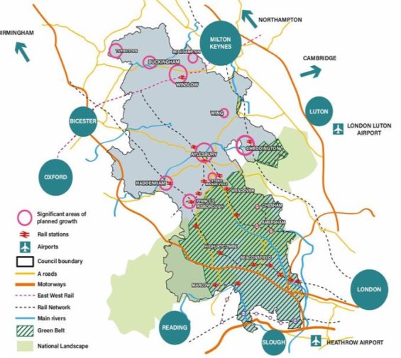
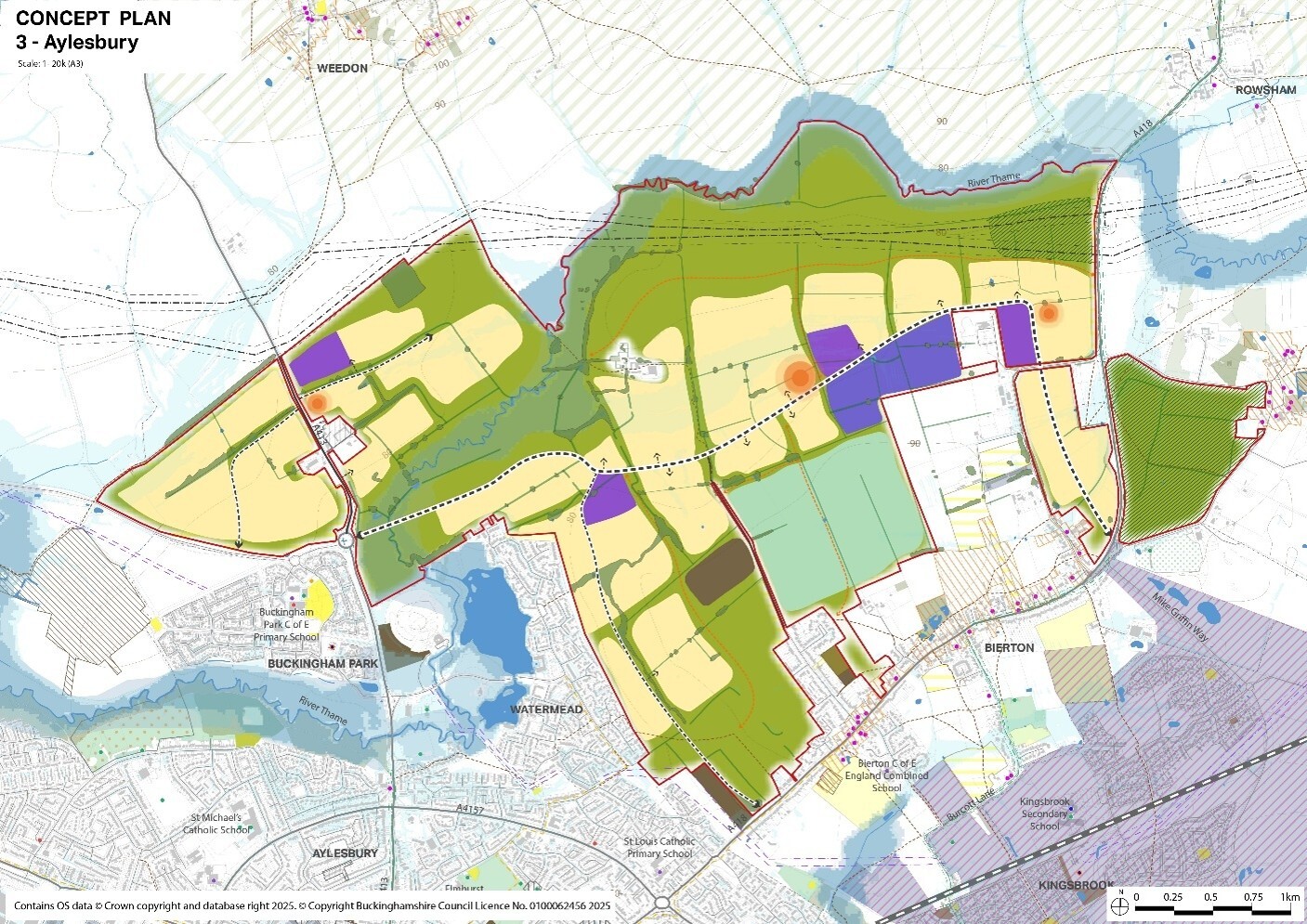
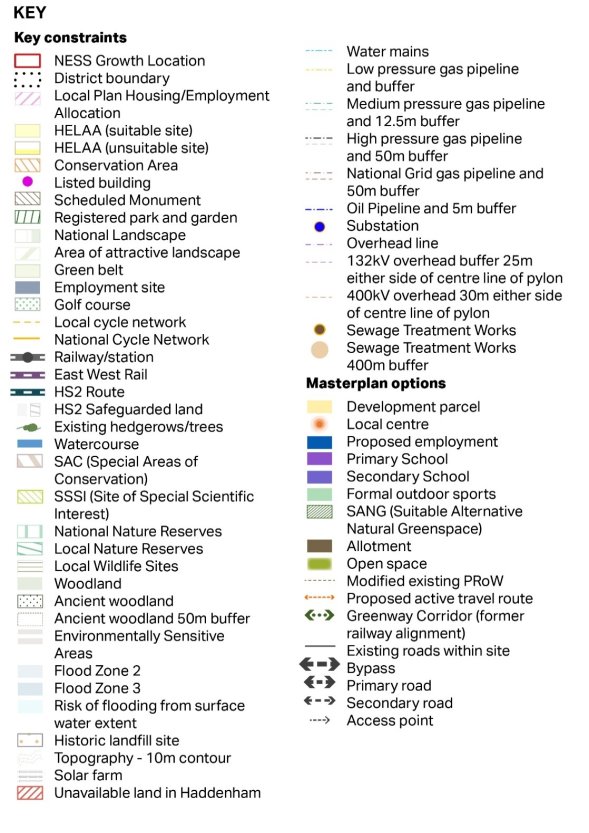
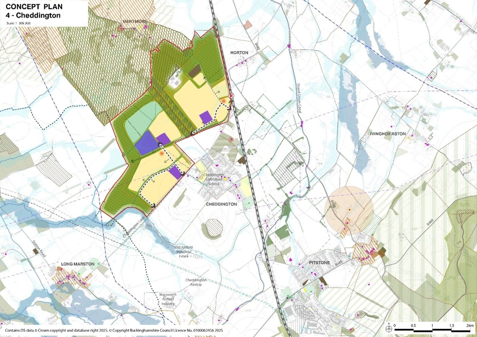
6.3The concept plans, included alongside the NESS site policies, illustrate the key principles for the development of the site and should be used to inform the preparation of any detailed masterplan and planning application. The precise location and configuration of land uses, infrastructure and open spaces may vary, provided that the overall objectives and requirements of the allocation are delivered. The NESS policy numbering reflects the original assessment of 18 potential NESS sites. As the site selection process progressed, the number of sites was reduced to 10; however, the original site reference numbers have been retained for consistency and audit purposes.
Strategic Sites – Housing and mixed use
NESS003 - Aylesbury
Policy NESS003: Aylesbury NESS
- This 529.7-hectare site, as shown on the Policies Map, is located to the north of Aylesbury, the heart of Buckinghamshire. The site is allocated for approximately 9,080 dwellings in this Local Plan, with 3,650 dwellings to be delivered in the plan period and fifteen net additional serviced Gypsy/ Traveller pitches.
- The site is allocated as a residential-led mixed-use development, including approximately 3,500 sqm of town centre uses, supporting infrastructure and community facilities.
Development requirements
- Planning permission will be granted where development accords with the requirements below and are supported by a comprehensive site-wide masterplan and phasing strategy:
Place-making and Design.
- Development must adopt a landscape-led approach which:
- Responds positively to the site’s edge of town and rural transition character.
- Reflects the existing field pattern and mature landscape features; and
- Integrates development into the surrounding townscape and countryside
- Development must establish a high-quality, distinctive and functional place and must:
- Respond to local context, including topography, landscape, habitats and ecological features.
- Retain and incorporate trees, hedgerows and existing green infrastructure as part of a connected network.
- Avoid areas of highest flood risk, including Flood Zones 2, 3a and 3b, and areas at significant risk of surface water flooding.
- Incorporate multifunctional sustainable drainage systems as part of the design and layout.
- Safeguard and enhance watercourses, including provision of appropriate buffers to the River Thame.
- Take account of infrastructure constraints, including provision of appropriate easements and stand-off distances.
- Maintain separation from nearby settlements, including Bierton to prevent coalescence and protect settlement character.
- Conserve and enhance the setting of the Bierton Conservation Area; and
- Be informed by up-to-date site-specific evidence, including flood risk and environmental assessments.
- Development should:
- Re-use existing farm buildings, where they make a positive contribution to local character and where viable and feasible to do so.
Movement and Connectivity
- Development must deliver a comprehensive movement strategy which prioritises sustainable transport and must:
- Provide the Northeast Aylesbury Link Road as the principal movement ccA418.or. Deliver a network of internal streets and connections to the A413 and A418.
- Ensure all highway infrastructure is informed by proportionate transport modelling and supports the safe operation of the network.
- Provides high quality public transport infrastructure and services, including:
- New or reconfigured bus services linking the site with Aylesbury town centre and railway station; and
- Supporting infrastructure, including bus priority measures where appropriate; and
- Prioritise walking, cycling and public transport to reduce reliance on the private car.
Community Facilities
- Development must provide a comprehensive range of community infrastructure, proportionate to its scale, including:
- Local centres providing retail, community, cultural and service uses, designed as accessible focal points.
- Land and buildings for four primary schools (6-15FE total).
- Land and buildings for a secondary school.
- On-site primary healthcare facilities, delivered in partnership with the Integrated Care Board (ICB).
- Contributions towards off-site healthcare and other strategic infrastructure as required; and
- Indoor and outdoor sports facilities, play space and recreation areas in accordance with Policy SE5: Sport, Leisure and Recreation and relevant standards.
Green and Blue Infrastructure
- Development must deliver a comprehensive and connected network of green and blue infrastructure which:
- Integrates watercourses, hedgerows, ecological features and areas of flood risk.
- Enhances biodiversity and ecological connectivity; and
- Reinforces local landscape character.
- Development must:
- Maintain a strategic green gap to the north associated with the River Thame floodplain.
- Maintain a strategic green gap to the south to:
- Prevent coalescence with surrounding settlements including Bierton; and
- Protect the setting of the Bierton Conservation Area.
- Development must provide multifunctional green infrastructure, including:
- Public open space, including land for SuDS.
- Outdoor sports facilities.
- Walking and cycling routes.
- Allotments; and
- Suitable Alternative Natural Greenspace (SANG) and contributions to Strategic Access Management and Monitoring (SAMM), in accordance with Policies NE12 and NE13, and the Chilterns Beechwoods SAC Mitigation Strategy.
Implementation, Phasing and Delivery
- Development will only be permitted where it is supported by a comprehensive and coordinated masterplan and phasing strategy for the entire site, to be submitted to and approved by the Council prior to the determination of any planning application.
- The masterplan and phasing strategy must:
- Demonstrate how development will be delivered in a coordinated and comprehensive manner across the site.
- Demonstrate coordinated and comprehensive delivery of off-site necessary infrastructure.
- Show how each phase integrates with the overall design and place-making principles.
- Identify the timing and provision of infrastructure necessary to support each phase.
- Include infrastructure delivery triggers and mechanisms, including use of planning obligations where necessary; and
- Demonstrate how piecemeal or uncoordinated development will be avoided.
- The scale and timing of infrastructure provision must be informed by viability and deliverability considerations, to be agreed with the Council.
Aylesbury NESS Site 003
6.4Land identified on the Policies Map and Indicative Diagram as Aylesbury NESS Site 003 is allocated to deliver a strategic, mixed-use urban extension to Aylesbury. At approximately 529.7 hectares, the site represents one of the most significant growth opportunities in Buckinghamshire and will play a key role in meeting housing and infrastructure needs over the Plan period and beyond.
6.5The allocation will deliver approximately 9,080 homes in total, of which around 3,650 are expected within the Plan period. Development will continue beyond the Plan period, reflecting the scale and long-term nature of the site, and will be considered in future plan-making.
6.6There were no extant planning permissions for residential development on the site as of June 2026.
Site Context and Key Characteristics
6.7The site lies to the north-east of Aylesbury, between the A413 and A418, and adjoins the Watermead development. It is near the settlements of Hulcott and Bierton. The site is agricultural in character, comprising large arable fields with a relatively open structure, interspersed with hedgerows, watercourses and Public Rights of Way.
6.8The River Thame forms a strong northern boundary and is a key environmental and landscape feature. Parts of the site are affected by fluvial and surface water flood risk, particularly within the river corridor and in lower-lying areas. These areas present both constraints and opportunities for the incorporation of green and blue infrastructure within the development.
6.9The site sits within a low-lying clay vale landscape, characterised by open views and a gently undulating landform. It forms an important transition between the built-up area of Aylesbury and the surrounding rural landscape. The setting of nearby settlements, particularly Bierton, and the Bierton Conservation Area are sensitive considerations which will influence the form and disposition of development.
6.10Existing infrastructure constraints, including utilities and strategic infrastructure corridors, will need to be carefully integrated into the design and layout of development. Opportunities also exist to re-use existing farm buildings where they contribute positively to local character and can be successfully incorporated.
Development Strategy and Design Approach
6.11The site will be developed as a comprehensively planned urban extension, with a strong emphasis on landscape-led design and high-quality place-making. Development will be required to respond positively to the site’s edge-of-settlement context and to create a series of well-connected neighbourhoods with a clear sense of identity.
6.12Green and blue infrastructure will form a structuring element of the development, with watercourses, floodplain areas, hedgerows and other landscape features integrated into a multifunctional network. This approach will support biodiversity enhancement, recreation, climate resilience and flood risk management, whilst reinforcing local character.
6.13Strategic green gaps will play an important role in the spatial framework of the site. Land to the north associated with the River Thame floodplain will remain undeveloped, while a further gap to the south will be maintained to prevent coalescence with Bierton and to protect its setting. These areas will also contribute to green infrastructure provision and visual separation.
Infrastructure and Community Provision
6.14Given the scale of development proposed, the site will be required to deliver a comprehensive range of supporting infrastructure and services to create a sustainable and self-contained community.
6.15This will include the provision of new local centres, acting as accessible focal points for retail, community, cultural and service uses. These centres will serve the day-to-day needs of residents and reduce the need to travel.
6.16Education provision will include four primary schools and one secondary school, with sites identified through the master planning process to ensure accessibility and integration with surrounding neighbourhoods.
6.17Healthcare infrastructure, including primary care facilities, will be delivered in partnership with the Integrated Care Board. The scale, specification and timing of provision will be informed by ongoing engagement and updated evidence at the planning application stage.
6.18Indoor and outdoor sport, recreation and play facilities will be provided across the site, contributing to health and wellbeing and aligned with local standards and policy requirements.
6.19In addition to on-site provision, development will be expected to contribute towards off-site infrastructure where necessary, including healthcare, emergency services, and other strategic requirements, in accordance with relevant policies and evidence.
Transport and Movement
6.20The transport strategy for the site is therefore designed to support sustainable growth whilst addressing existing congestion issues within Aylesbury and the surrounding area.
6.21A key element of this strategy is the delivery of the Northeast Aylesbury Link Road, which will provide a direct connection between the A413 and A418 and enable movement around the town. This will help to reduce pressure on the town centre and existing radial routes.
6.22Development will also be required to promote sustainable travel patterns, including enhanced public transport provision and a comprehensive network of walking and cycling routes. These measures will support modal shift and reduce reliance on the private car.
6.23Detailed transport assessments and modelling, to be agreed with the Council as the Highway Authority, will be required at the planning application stage to inform the design of the movement network and the identification of any necessary mitigation measures.
Environmental Considerations and Mitigation
6.24A site-specific, risk-based approach to flood risk will be required, informed by the most up-to-date evidence, including the Level 2 Strategic Flood Risk Assessment and subsequent detailed assessments. Development will be directed away from areas of highest flood risk, with these areas utilised as part of the green infrastructure network where appropriate.
6.25Sustainable drainage systems will be integrated throughout the site to manage surface water, improve water quality and provide wider environmental benefits.
6.26The site lies partly within the Zone of Influence of the Chilterns Beechwoods Special Area of Conservation (SAC). Development will therefore be required to deliver or contribute towards Suitable Alternative Natural Greenspace (SANG) and Strategic Access Management and Monitoring Measures (SAMM), in accordance with the Council’s mitigation strategy.
6.27SANG is expected to be delivered on site where feasible, making use of existing landscape features and the wider green infrastructure network. Alternative or supplementary provision may be made through strategic SANG where appropriate.
6.28Planning applications will need to be supported by sufficient information to enable the Council to undertake an Appropriate Assessment where required.
Delivery, Masterplanning and Phasing
6.29Given the scale, complexity and multiple ownerships of the site, a comprehensive and coordinated approach to delivery will be essential.
6.30Development will be guided by a site-wide masterplan and phasing strategy, which will establish the overall spatial framework, land use distribution, infrastructure requirements and delivery sequence.
6.31The masterplanning process will ensure that development is integrated across the site, with infrastructure provided in a timely manner to support each phase and to avoid piecemeal or uncoordinated development.
6.32A design code will be required to secure high-quality and consistent design outcomes across all phases of development. This will be aligned with the Buckinghamshire Design Code and will guide the detailed form and appearance of development.
6.33The delivery of the site, including housing trajectories and infrastructure provision, will be monitored through the Council’s monitoring framework to ensure that the development comes forward as anticipated and contributes effectively to the overall strategy of the Local Plan.
NESS004 - Cheddington
Policy NESS004: Cheddington NESS
- This 342.1-hectare site is located to the north-east of Buckinghamshire, adjacent to Cheddington in proximity to Leighton Buzzard in Central Bedfordshire.
- Land identified on the Policies Map is allocated for a strategic residential-led mixed-use development, delivering a minimum of 5,090 dwellings, of which 3,650 dwellings are expected to be delivered within the plan period, alongside 12 net additional serviced Gypsy and Traveller pitches, 3,500 sqms of town centre uses, supporting infrastructure and green and blue infrastructure.
Development requirements
- Planning permission will be granted where development accords with the requirements below and are supported by a comprehensive site-wide masterplan and phasing strategy:
Place making and design.
- Development must establish a high quality, distinctive and functional place and must:
- Respond positively to the site’s landscape character, topography and environmental context.
- Integrate development with surrounding rural character and settlement pattern.
- Take account of the centrally located solar farm and associated sub-station.
- Conserve and where opportunities arise enhance the significance and setting of Mentmore Towers Registered Park and Garden (RPG) and the Mentmore Conservation Area, including provision of appropriate green buffers.
- Respond positively to the Grand Union Canal corridor, including its heritage assets and environmental value.
- Retain and incorporate existing hedgerows as part of a connected green infrastructure network.
- Repurpose the former railway alignment as a multifunctional green infrastructure corridor.
- Avoid areas of highest flood risk and incorporate sustainable drainage systems.
- Account for infrastructure constraints, including provision of easements and buffers.
- Assess and mitigate potential impacts from nearby sewage treatment infrastructure; and
- Ensure strong physical and visual connectivity between development parcels.
- Development should reuse existing features where they contribute positively to local character and where feasible to do so.
Movement and Connectivity
- Development must deliver a comprehensive movement strategy which prioritises sustainable transport and must:
- Deliver the Horton Bypass connecting Station Road and the B488.
- Deliver a new railway bridge and associated road improvements at Station Road.
- Provide a network of internal spine roads and connections to the wider highway network.
- Ensure infrastructure is informed by proportionate and robust transport modelling; and
- Address cross-boundary transport impacts in collaboration with relevant authorities.
- Development must provide enhanced public transport, including:
- Improved bus services connecting the site with surrounding settlements; and
- Improved accessibility to Cheddington railway station.
- Development must provide a comprehensive walking, cycling and Public Rights of Way network which:
- Connects neighbourhoods, facilities and surrounding settlements.
- Integrates and enhances existing PROW; and
- Contributions to and the delivery of strategic active travel routes, including along the former railway corridor.
Community Facilities and Services
- Development must provide a comprehensive range of community infrastructure, including.
- Local centres providing retail and community uses as accessible focal points.
- Land and buildings for three primary schools (6-8 FE).
- Land and buildings for one secondary school.
- On- site primary healthcare provision or contributions to off-site provision, as agreed with the Council and Integrated Care Board.
- Indoor and outdoor sport, recreation and play facilities in accordance with Policy SE5: Sport, Leisure and Recreation and relevant standards.
Green and Blue Infrastructure
- Development must deliver a comprehensive green and blue infrastructure network which:
- Integrates flood risk areas, watercourses and environmental features.
- Enhances biodiversity and ecological connectivity, and
- Reinforces landscape character.
- Development must:
- Provide green buffers to protect important views to listed buildings along the Grand Union Canal; and
- Deliver Suitable Alternative Natural Greenspace (SANG) and contributions to Strategic Access Management and Monitoring (SAMM), in accordance with policies NE12 and NE13, and the Chilterns Beechwoods SAC Mitigation Strategy.
- Development must provide multifunctional green infrastructure including:
- Public open space.
- Sustainable drainage systems.
- Outdoor sports provision.
- Walking and cycling routes; and
- Allotments.
Implementation, Phasing and Delivery
- Development will only be permitted where it is supported by a comprehensive, site-wide masterplan and phasing strategy.
- The masterplan and phasing strategy must:
- Demonstrate coordinated and comprehensive delivery across the site.
- Demonstrate coordinated and comprehensive delivery of off-site necessary infrastructure.
- Show how each phase integrates with the overall design and place-making principles.
- Identify infrastructure delivery timing and triggers.
- Include mechanisms to ensure delivery and avoid piecemeal development; and
- Address cross-boundary coordination.
- The timing and phasing of infrastructure delivery shall be informed by viability and deliverability considerations, and agreed with the Council, whilst ensuring that development remains acceptable in planning terms
Overview and Context
6.34The Cheddington NESS site, as shown on the Policies Map and Indicative Diagram, is in the north-east of Buckinghamshire, close to the boundary with Central Bedfordshire and near Leighton Buzzard. It lies within the Vale of Aylesbury, characterised by a rural landscape of flat to gently undulating clay vale farmland.
6.35The allocation will deliver a minimum of 5,090 homes, of which 3,650 dwellings are expected to be delivered within the plan period, including Gypsy and Traveller provision, alongside supporting infrastructure and services. Development will be phased, with a substantial proportion delivered within the Plan period.
Site Characteristics
6.36The site lies within the Vale of Aylesbury and is characterised by a flat, open agricultural landscape with limited enclosure. Hedgerows, watercourses and occasional historic features contribute to local distinctiveness.
6.37The setting of Mentmore Towers Registered Park and Garden and Conservation Area is a key consideration, alongside the Grand Union Canal corridor and associated heritage assets.
6.38Infrastructure features, including transport corridors and utilities, influence the site and will need to be integrated into development.
Development Strategy and Design Approach
6.39Development will be brought forward as a comprehensively planned new settlement, with a strong emphasis on landscape-led design and place-making.
6.40Green and blue infrastructure will form a key structuring element, incorporating flood risk areas, hedgerows and the former railway alignment into a connected network.
6.41Strategic green buffers will be provided to protect the setting of heritage assets, including Mentmore Towers and the canal corridor.
Infrastructure and Community Provision
6.42The scale of development requires a full range of infrastructure, including education, healthcare. Local centres and recreation facilities.
6.43Healthcare provision will be informed by ongoing engagement with the Integrated Care Board and the latest evidence at the planning application stage.
6.44Development will also contribute to off-site infrastructure where required.
Transport and Movement
6.45The transport strategy is designed to support sustainable growth while mitigating impacts on surrounding communities.
6.46Key components include the Horton Bypass, improvements to Station Road, and a new railway bridge to overcome existing constraints. These form part of a comprehensive package of improvements necessary for the growth in the area. Developers will be required to coordinate the delivery of these requirements.
6.47Sustainable transport measures, including improvements to bus services, rail access, and walking and cycling networks, will reduce reliance on the private car.
6.48Cross-boundary impacts will be addressed in collaboration with neighbouring authorities.
Environmental Considerations and Mitigation
6.49Flood risk will be managed through a risk-based approach informed by the latest evidence, directing development away from higher-risk areas.
6.50The site lies within the Chilterns Beechwoods SAC Zone of Influence. Development must provide mitigation through SANG and SAMM.
6.51SANG is expected to be delivered on site where feasible, with alternative provision where necessary.
6.52Planning applications must provide sufficient information to enable the Council to undertake an Appropriate Assessment where required.
Delivery, Masterplanning and Phasing
6.53A coordinated approach is essential due to the scale, complexity and cross-boundary nature of the site.
6.54Development will be guided by a comprehensive site-wide masterplan and phasing strategy.
6.55A design code will be required to ensure high-quality and consistent development.
6.56Delivery will be monitored through the Council’s monitoring framework.
NESS005 - Haddenham
Policy NESS005: Haddenham NESS
- This 293.6-hectare site, as shown on the Policies Map, is located to the south-west of Aylesbury, adjoining Haddenham.
- The site is allocated for a residential-led urban extension delivering a minimum of 6,610 dwellings, of which approximately 3,545 will be delivered within the Plan period, alongside 7 net additional serviced Gypsy and Traveller pitches, 3,500 sq.m of town centre uses, supporting infrastructure, community facilities, and green and blue infrastructure.
Development requirements
- Planning permission will be granted where development accords with the requirements below and are supported by a comprehensive site-wide masterplan and phasing strategy:
Place-making and Design.
- Development must adopt a landscape-led approach which:
- Responds positively to the site’s rural and edge-of-settlement character.
- Reflects existing field patterns, hedgerows and landscape features; and
- Minimises visual and landscape impacts, particularly within the northern parcels.
- Development must establish a high-quality, distinctive and functional place and must:
- Integrate with existing employment and residential uses.
- Retain and provide Gypsy and Traveller provision, including extension of the existing site.
- Retain and incorporate trees, hedgerows and landscape features within a connected green infrastructure network.
- Respond appropriately to site constraints, including the historic landfill and utilities infrastructure.
- Integrate Snakemoor Nature Reserve within the green infrastructure network.
- Conserve and enhance the significance and setting of heritage assets, including Wheatclose Cottage and Haddenham Conservation Area.
- Avoid areas of highest flood risk and incorporate sustainable drainage systems; and
- Be informed by up-to-date site-specific environmental and technical evidence.
- Development must address the presence of Haddenham Wastewater Treatment Works (WwTW) and will only be permitted where:
- Living conditions are not adversely affected by odour or emissions.
- The continued operation and maintenance of the WwTW is not compromised.
- Site design has been informed by engagement with the operator; and
- Appropriate mitigation measures are incorporated.
Movement and Connectivity
- Development must deliver a comprehensive movement strategy which prioritises sustainable transport and must:
- Provide access from the A418 and surrounding road network.
- Deliver an integrated network of internal routes.
- Ensure infrastructure provision is informed by proportionate transport modelling and supports the safe operation of the network; and
- Address cross-boundary transport impacts in collaboration with relevant authorities.
- Development must:
- Enhance public transport provision, including improved access to Haddenham and Thame Parkway Station; and
- Provide improved bus services linking the site to surrounding settlements.
- Development must provide a comprehensive walking, cycling and Public Rights of Way network which:
- Connects the site with the village, station and surrounding countryside.
- Integrates and enhances existing PROW; and
- Provides new active travel routes across the site.
Community Facilities and Services
- Development must provide a comprehensive range of community infrastructure, including:
- Local centres providing retail and community uses as accessible focal points.
- Land and buildings for three primary schools (6-11FE total).
- Land and buildings for one secondary school.
- On-site primary healthcare facilities or contributions to off-site provision as agreed; and
- Indoor and outdoor sport, recreation and play provision in accordance with Policy SE5.
- Retail provision must be of a scale and type that meets local needs and supports, and does not undermine, existing centres.
Green and Blue Infrastructure
- Development must deliver a connected network of green and blue infrastructure which:
- Integrates Snakemoor Nature Reserve, watercourses and flood risk areas.
- Enhances biodiversity and ecological connectivity; and
- Reinforces local landscape character.
- Development must provide:
- Strategic green buffers to minimise landscape and visual impacts, including along the A418 corridor.
- Green buffers to maintain separation between settlements and protect the wider countryside; and
- A multifunctional green infrastructure network including open space, SuDS, active travel routes and allotments.
Implementation, Phasing and Delivery
- Development will only be permitted where it is supported by a comprehensive site-wide masterplan and phasing strategy.
- The masterplan and phasing strategy must:
- Demonstrate coordinated delivery across the site.
- Demonstrate coordinated and comprehensive delivery of off-site necessary infrastructure.
- Show how each phase integrates with the overall design.
- Identify infrastructure delivery timing and triggers.
- Include mechanisms to avoid piecemeal development; and
- Ensure alignment with relevant infrastructure evidence.
- Infrastructure provision must be informed by viability and deliverability considerations, to be agreed with the Council.
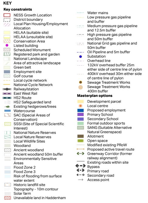
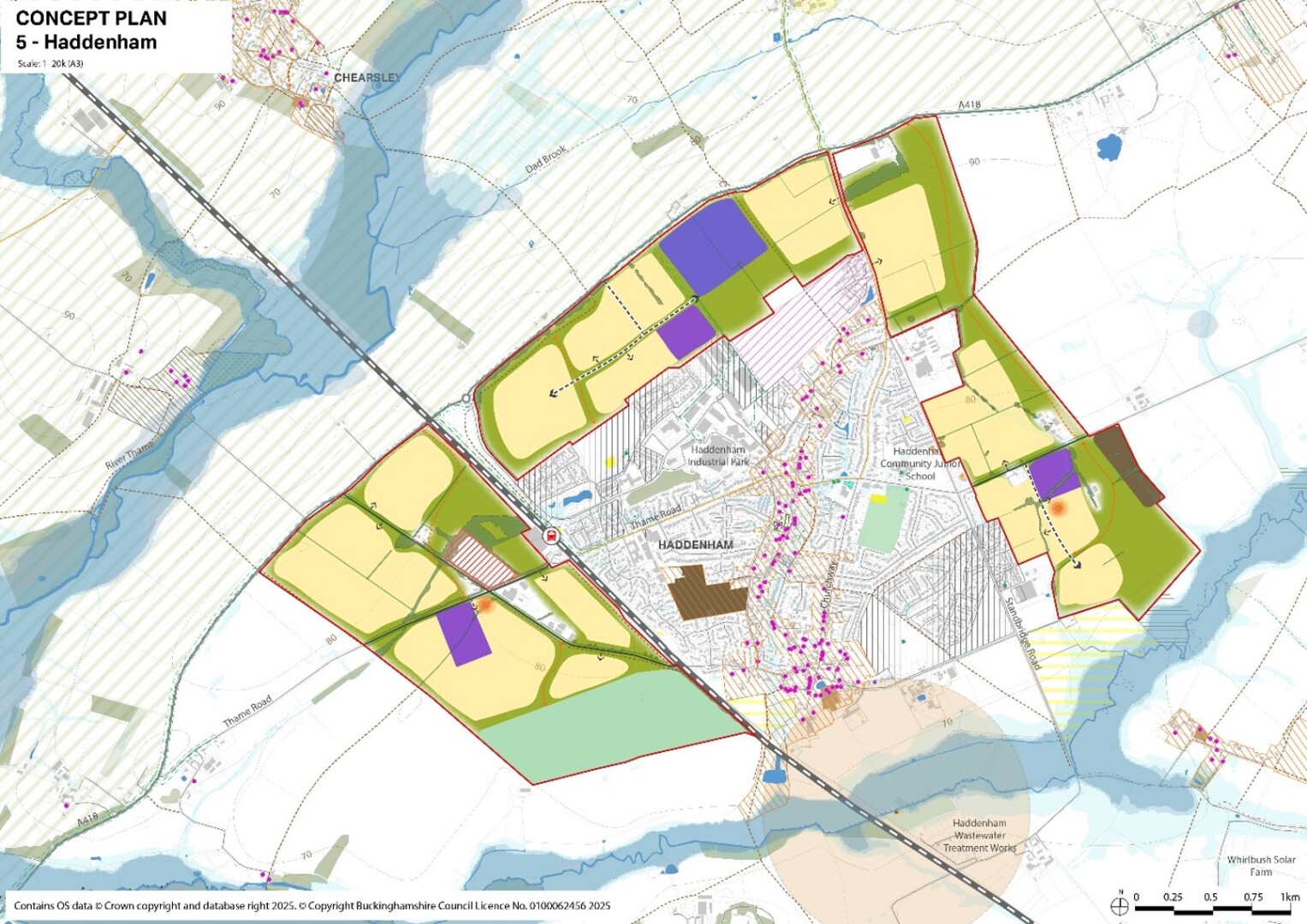
6.57Land identified as Haddenham NESS Site 005 on the Policies Map and Indicative Diagram is allocated to deliver a strategic urban extension adjoining Haddenham. The site extends to approximately 293.6 hectares and represents a significant opportunity to accommodate housing growth alongside supporting infrastructure.
6.58The development will deliver a minimum of 6,610 homes, of which approximately 3,545 will be delivered in the Plan period, together with community facilities, green infrastructure and supporting services. Development will be phased, with a substantial proportion delivered within the Plan period.
Site Characteristics
6.59The site lies within a predominantly rural landscape characterised by relatively flat topography and large-scale agricultural fields. Hedgerows, tree belts and Public Rights of Way provide structure and connections within the landscape.
6.60The proximity of Haddenham and Thame Parkway Station is a key characteristic, providing opportunities to support sustainable travel patterns.
6.61Snakemoor Nature Reserve and other environmental features contribute to the ecological value of the area, while heritage assets, including Haddenham Conservation Area and listed buildings, represent important constraints and opportunities.
6.62The site is influenced by several infrastructure constraints, including a historic landfill, utilities infrastructure and the nearby wastewater treatment works.
Development Strategy and Design Approach
6.63The site will be developed as a comprehensively planned urban extension, with a strong emphasis on landscape-led design and integration with the existing village.
6.64Green and blue infrastructure will form a key element of the development, integrate natural features and provide multifunctional spaces for recreation, biodiversity and flood risk management.
6.65Development will respond to the site’s context, ensuring that landscape and visual impacts are appropriately mitigated, particularly along the A418 corridor and at the rural edge of the settlement.
Infrastructure and Community Provision
6.66The scale of development requires provision of a wide range of infrastructure, including local centres, education, healthcare and recreation facilities.
6.67Healthcare provision will be informed by ongoing engagement with the Integrated Care Board and updated evidence at the planning application stage.
6.68Development will also be required to contribute towards off-site infrastructure where necessary.
Transport and Movement
6.69The transport strategy is designed to support sustainable growth and minimise impacts on the surrounding network.
6.70Key measures include new site accesses, improvements to the A418 and surrounding junctions, and integration with the wider highway network.
6.71Sustainable transport will be prioritised, including improved access to Haddenham and Thame Parkway Station, enhanced bus services, and a comprehensive walking and cycling network.
6.72Cross-boundary transport impacts will be addressed through engagement with neighbouring authorities.
Environmental Considerations and Mitigation
6.73Flood risk will be managed through a risk-based approach, directing development away from higher risk areas and integrating sustainable drainage systems.
6.74The proximity of the wastewater treatment works requires careful design and mitigation to ensure acceptable living conditions and continued operation of the facility.
6.75Planning applications must provide sufficient information to enable the Council to undertake an Appropriate Assessment where required.
Delivering, Masterplanning and Phasing
6.76Due to the scale and complexity of the site, development will be guided by a comprehensive masterplan and phasing strategy.
6.77This will ensure coordinated delivery of development, infrastructure and mitigation, and avoid piecemeal development.
6.78A design code will be required to ensure high-quality and consistent design across the site.
6.79Delivery will be monitored through the Council’s monitoring framework.
NESS008 - Buckingham
Policy NESS008: Buckingham NESS
- This 217.5-hectare site, as shown on the Policies Map, is located to the south-west of Buckingham, in the north of Buckinghamshire.
- The site is allocated for a residential-led urban extension delivering a minimum of 4,700 dwellings, of which approximately 2,235 dwellings will be delivered within the Plan period, alongside 10 net additional serviced Gypsy and Traveller pitches, approximately 1.7 hectares of employment land, around 2,000 sq.m of town centre uses, supporting infrastructure, and 10 net additional serviced Gypsy and Traveller pitches.
Development requirements
- Planning permission will be granted where development accords with the requirements below and are supported by a comprehensive site-wide masterplan and phasing strategy:
Place making and design.
- Development must adopt a landscape-led approach which:
- Responds positively to the site’s rural character and edge-of-settlement location.
- Reflects existing field patterns, hedgerows and landscape features; and
- Integrates development sensitively into the wider countryside setting.
- Development must establish a high-quality, distinctive and functional place and must:
- Retain and integrate existing land uses where appropriate.
- Address the presence of the solar farm, including its removal or reconfiguration where justified.
- Retain and incorporate hedgerows and woodland within a connected green infrastructure network.
- Respond to site constraints, including the historic landfill site.
- Manage flood risk through layout, design and sustainable drainage systems; and
- Conserve and enhance the setting of Gawcott Conservation Area.
Movement and Connectivity
- Development must deliver a comprehensive movement strategy which prioritises sustainable transport and must:
- Provide the Buckingham South Spine Road linking the A413 to the A421, including appropriate access arrangements.
- Deliver a network of internal roads connecting to the wider highway network.
- Ensure infrastructure provision is informed by proportionate transport modelling and supports the safe operation of the network; and
- Provide connections to key routes including the A413, A421 and local roads.
- Development must provide a comprehensive walking, cycling and Public Rights of Way network which:
- Connects the site with Buckingham, employment areas, retail facilities and community services.
- Retains and enhances existing PROW; and
- Integrates with the Buckinghamshire Greenway and wider network.
Community Facilities and Services
- Development must provide a comprehensive range of community infrastructure, including:
- Local centres providing retail and community uses as accessible focal points.
- Land and buildings for three primary schools (4-7FE total).
- Land and buildings for one secondary school.
- On-site primary healthcare facilities or contributions to off-site provision as agreed; and
- Indoor and outdoor sport, recreation and play provision in accordance with Policy SE5.
- Retail provision must be of a scale and type that meets local needs and supports, and does not undermine, existing centres.
Green and Blue Infrastructure
- Development must deliver;
- connected network of green and blue infrastructure which:
- Incorporates areas of flood risk.
- Enhances biodiversity and ecological connectivity; and
- Reinforces landscape character.
- Development must:
- Provide a substantial green buffer along the southern boundary to protect the setting of Gawcott Conservation Area; and
- Maintain the rural character of Lenborough Road.
- Development must provide multifunctional green infrastructure including:
- Public open space;
- Sustainable drainage systems;
- Outdoor sports facilities;
- Walking and cycling routes; and
- Allotments.
Implementation, Phasing and Delivery
- Development will only be permitted where it is supported by a comprehensive site-wide masterplan and phasing strategy.
- The masterplan and phasing strategy must:
- Demonstrate coordinated delivery across the site.
- Demonstrate coordinated and comprehensive delivery of off-site necessary infrastructure.
- Show how each phase integrates with the overall design.
- Identify infrastructure delivery timing and triggers.
- Include mechanisms to avoid piecemeal development; and
- Ensure alignment with infrastructure evidence.
- Infrastructure provision must be informed by viability and deliverability considerations, to be agreed with the Council.
Buckingham NESS Site 008
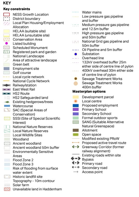
6.79Land identified, on the Policies Map and Indicative Diagram below, as Buckingham NESS Site 008 is allocated to deliver a strategic urban extension to the south-west of Buckingham. The site extends to approximately 217.5 hectares and provides an opportunity for a comprehensive and well-integrated expansion of the town.
6.80The development will deliver a minimum of 4,700 homes, of which approximately 2,235 will be delivered in the Plan period, alongside employment, community infrastructure and supporting services. A significant proportion will be delivered within the Plan period.
Site Characteristics
6.81The site lies within a predominantly rural landscape characterised by gently undulating agricultural land, with hedgerows, field patterns and watercourses providing structure.
6.82It forms part of the setting of Buckingham and nearby settlements including Gawcott and includes features such as a solar farm and a historic landfill site.
6.83Watercourses, including the River Great Ouse and Padbury Brook, are key environmental features which influence the design and layout of development.
6.84The site is located close to existing services, employment areas and facilities within Buckingham.
Development Strategy and Design Approach
6.85The site will be developed as a comprehensively planned urban extension, with a strong emphasis on landscape-led design and integration with the existing settlement.
6.86Green and blue infrastructure will form a key component of the scheme, incorporate natural features and support biodiversity, recreation and flood risk management.
6.87Development will respond to the site’s context, including its relationship with Gawcott and the surrounding countryside.
Infrastructure and Community Provision
6.88The scale of development requires provision of a wide range of infrastructure, including local centres, education, healthcare and recreation facilities.
6.89Healthcare provision will be informed by ongoing engagement with the Integrated Care Board and the latest evidence at the planning application stage.
6.90Development will also contribute towards off-site infrastructure where required.
Transport and Movement
6.91The transport strategy is designed to support sustainable growth and manage impacts on the surrounding network.
6.92The Buckingham South Spine Road will provide a key route through the development and assist in distributing traffic.
6.93Improvements to key routes including the A413, A421 and local roads will be required to maintain safe and efficient operation. There is also a longstanding strategic aspiration for a Buckingham western relief road between the A421 and A422.
6.94Sustainable transport measures, including bus improvements and walking and cycling infrastructure, will reduce reliance on the private car.
Delivery, Masterplanning and Phasing
6.95Development will be brought forward through a coordinated masterplanning process to ensure integrated delivery.
6.96A site-wide masterplan and phasing strategy will guide the development and ensure timely infrastructure provision.
6.97A design code will be required to secure high-quality outcomes across the site.
6.98Delivery will be monitored through the Council’s monitoring framework.
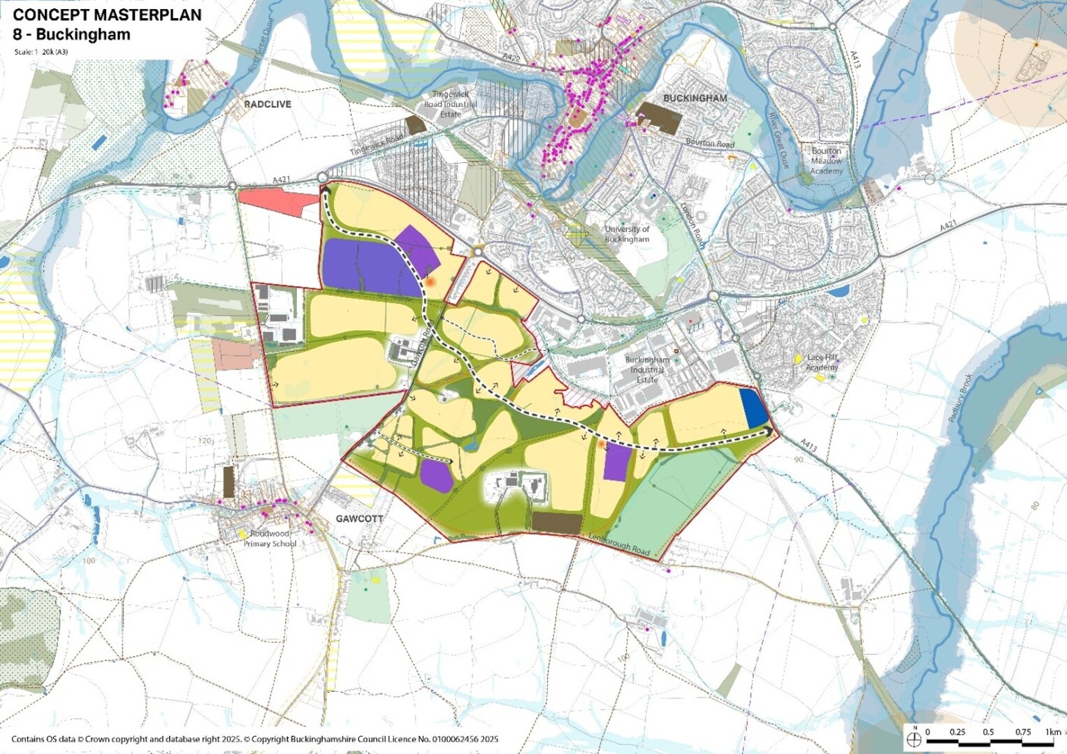
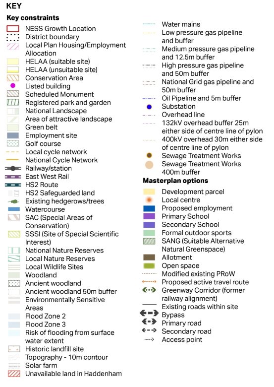
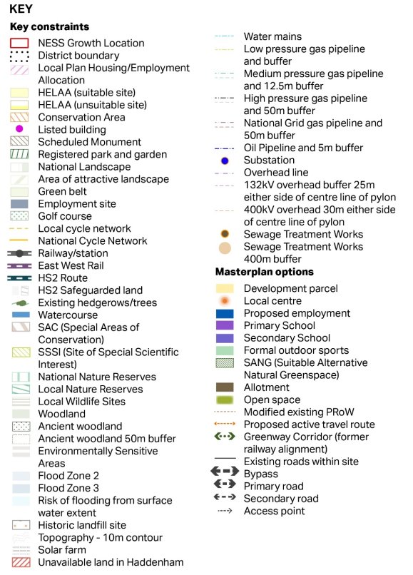
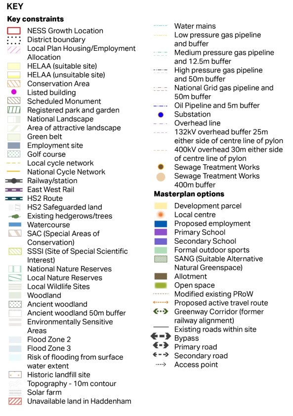
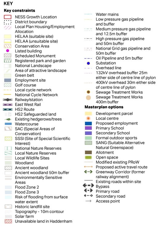
Figure 14: NESS Concept Masterplan Key (reproduced from Figure 8)
NESS010 - Princes Risborough
Policy NESS010: Princes Risborough NESS
- This 177.2-hectare site, as shown on the Policies Map, is allocated for a residential-led urban extension to Princes Risborough, delivering up to 2,895 dwellings within the Plan period.
- Development will include 11 net additional serviced Gypsy and Traveller pitches, a local centre providing approximately 300–400 sq.m of retail floorspace and around 500 sq.m of business space, supporting infrastructure, social infrastructure including education provision, a comprehensive movement corridor including green and blue infrastructure.
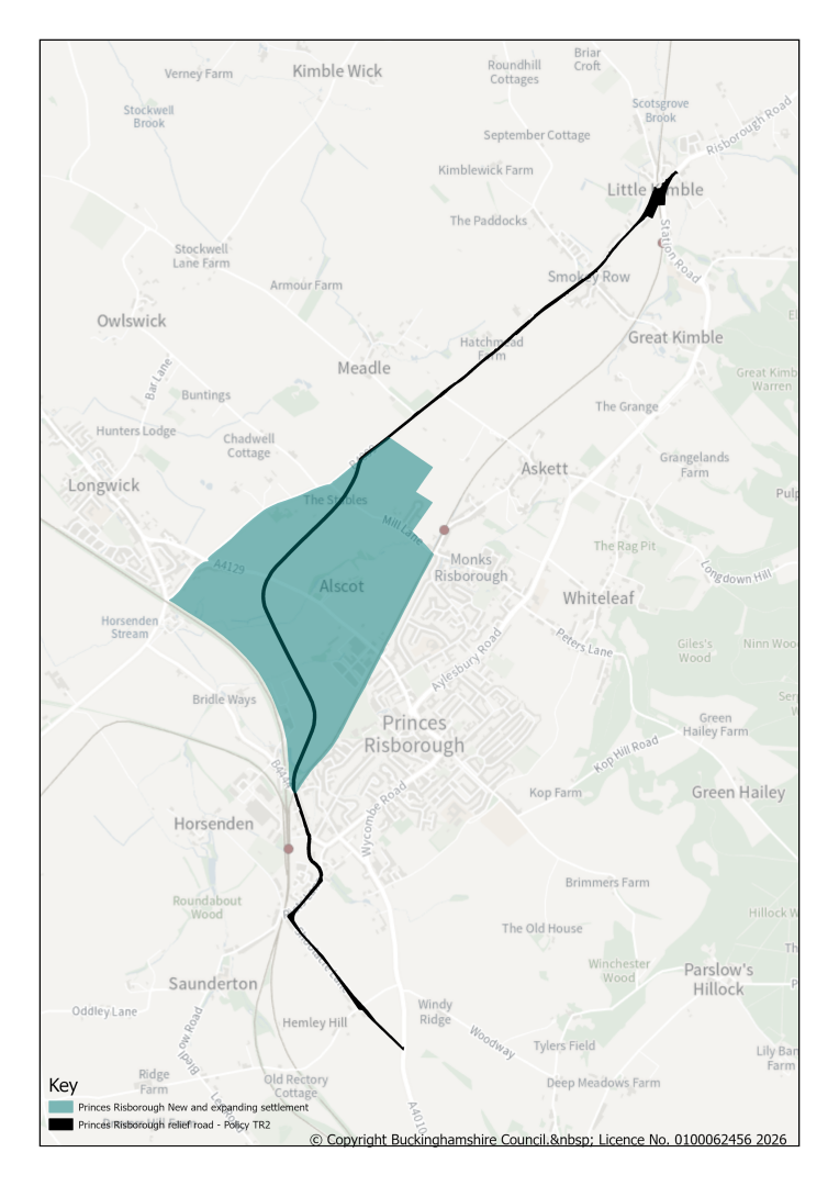
- Development will deliver the Princes Risborough Relief Road and associated works, as safeguarded by policy TR2 and shown on the Policies Map, which will provide a complete new alternative route to the A4010.
Development Requirements
- Planning permission will be granted where development accords with the requirements below and are supported by a comprehensive site-wide masterplan and phasing strategy:
Place making and design.
- Development must establish a high-quality, distinctive and functional place and must:
- Deliver a comprehensive movement corridor through the site forming part of the Princes Risborough Relief Road to support the effective operation of the local road network.
- Provide a strategic green corridor along the Crowbrook and north–south green links aligned with existing rights of way.
- Retain and integrate existing landscape features, land uses and site boundaries, including railway corridors, and respond to the setting of the Chilterns National Landscape.
- Retain and provide 6 net additional serviced Gypsy and Traveller and Travelling Showpeople provision, including extensions to existing sites.
- Retain and incorporate hedgerows and woodland within a connected green infrastructure network.
- Conserve and where opportunities arise enhance the significance and setting of heritage assets through design, layout and appropriate buffers.
- Protect and where opportunities arise enhance ecological assets, including Local Wildlife Sites.
- Respond to infrastructure constraints, including gas pipelines.
- Address potential impacts from wastewater treatment infrastructure, ensuring appropriate separation and mitigation.
- Integrate the development with the existing town, including across railway corridors; and
- Promote sustainable development, including efficient use of resources, renewable energy and biodiversity enhancement.
Movement and Connectivity
- Development must deliver a comprehensive movement strategy which prioritises sustainable transport and must:
- Deliver the Princes Risborough Relief Road (between Shootacre Lane junction with A4010 and Grove Lane junction with A4010), including on site provision of the route between Summerleys Road and the B4009, and including necessary off site associated works.
- Deliver connections to the existing highway network.
- Include appropriate traffic management measures where required, including through the town centre; and
- Ensure infrastructure is informed by proportionate transport modelling and supports the safe operation of the network.
- Development must:
- Enhance public transport connectivity, including integration with rail services; and
- Support improvements to bus provision.
- Development must provide a comprehensive walking, cycling and Public Rights of Way network which:
- Includes new and enhanced shared use routes.
- Retains and improves existing PROW and National Cycle Routes; and
- Provides strategic connections to surrounding settlements.
- Development must include but not limited to:
- Safeguard land for potential future railway improvements; and
- Provide safe and convenient pedestrian and cycle routes and improve active travel connections to surrounding settlements and railway crossings, including grade-separated crossings where appropriate.
- A diversion of the Church Path Public Right of Way, with a high-quality underpass under the railway in the north-eastern corner of Wades Park
- A diversion of the Mount Way footpath (Public Right of Way) to the new underpass to Wades Park.
Community Facilities and Services
- Development must provide a comprehensive range of community infrastructure, including:
- Local centres providing retail, business, and community uses as accessible focal points.
- Land and buildings for two primary school (5FE total);
- Contributions towards secondary off-site education provision.
- Primary healthcare provision or contributions to off-site provision as agreed with the Council and ICB; and
- Indoor and outdoor sport, recreation and play facilities in accordance with Policy SE5: Sport, Leisure and Recreation and other appropriate standards.
Green and Blue Infrastructure
- Development must deliver a connected network of green and blue infrastructure which:
- Integrates watercourses, landscape features and areas of flood risk.
- Enhances biodiversity and ecological connectivity; and
- Reinforces landscape character.
- Development must:
- Provide green buffers alongside railway corridors to mitigate impacts on amenity.
- Maintain strategic green gaps to preserve settlement separation and landscape character; and
- Provide buffers to conserve the setting of Conservation Areas.
- Development must provide multi-functional green infrastructure including:
- Public open space.
- Sustainable drainage systems.
- Outdoor sports facilities.
- Walking and cycling routes; and
- Allotments.
Implementation, Phasing and Delivery
- Development will only be permitted where it is supported by a comprehensive and coordinated site-wide masterplan and phasing strategy.
- The masterplan and phasing strategy must:
- Demonstrate coordinated delivery across the site.
- Demonstrate coordinated and comprehensive delivery of off-site necessary infrastructure.
- Ensure that proportionate equitable contributions are made to offsite infrastructure.
- Show how each phase integrates with the overall design.
- Identify infrastructure delivery timing and triggers.
- Include mechanisms to avoid piecemeal development; and
- Ensure alignment with the latest infrastructure evidence and site-specific assessments.
Princes Risborough NESS Site 010
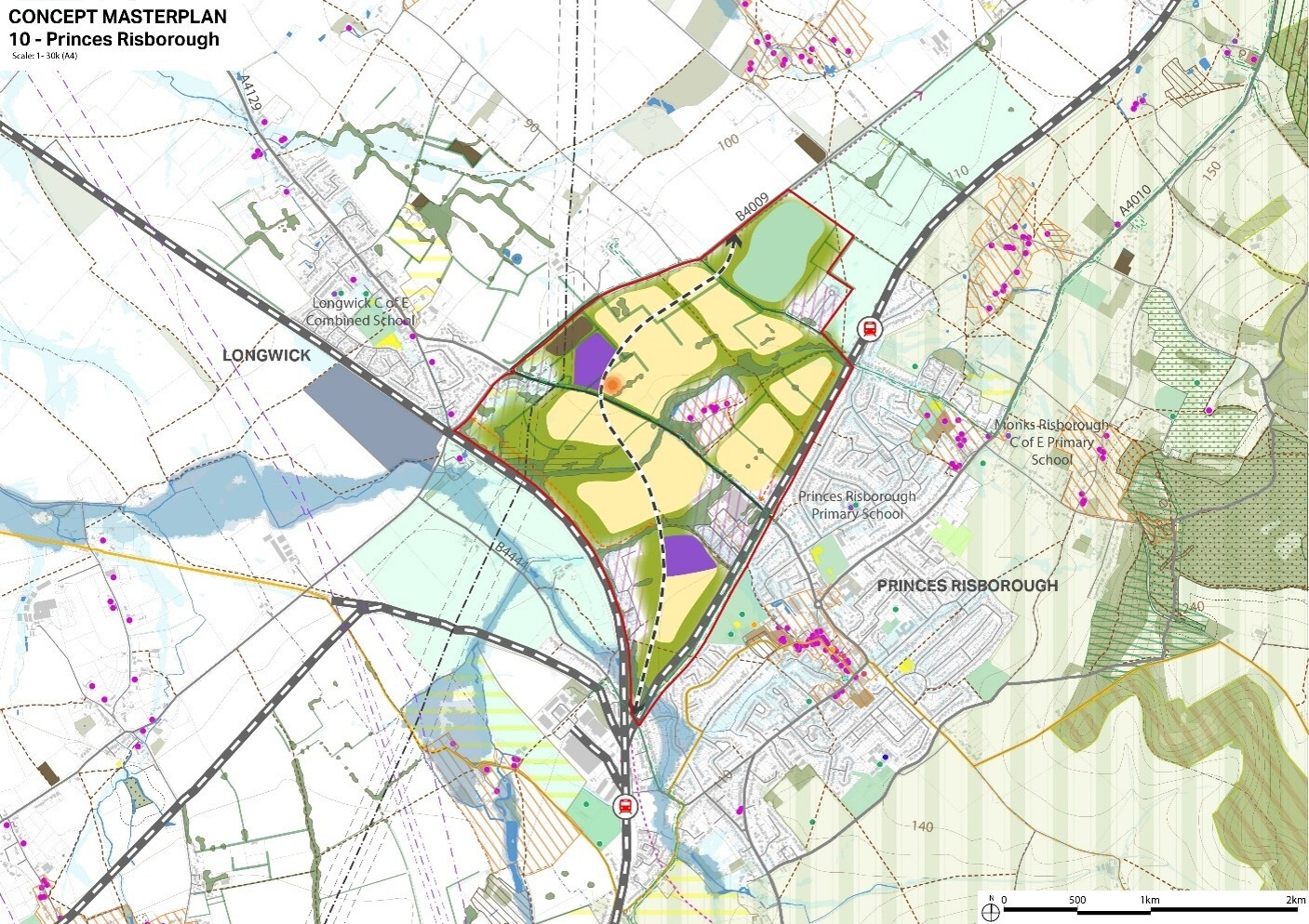
6.99The Princes Risborough Expansion Area, as shown on the Policies Map and Indicative Diagram, extends to approximately 177 hectares to the north and west of the town and builds on the allocation in the Wycombe District Local Plan (2019). It forms a key component of the strategy for sustainable growth in this part of Buckinghamshire.
6.100The site will deliver up to 2,895 homes alongside supporting infrastructure, community facilities and green infrastructure and some additional gypsy and traveller pitches.
Site Characteristics
6.101The site lies within a transitional landscape at the foot of the Chiltern Hills. Although outside the Chilterns National Landscape, it contributes to its wider setting and is visible from elevated viewpoints.
6.102It comprises agricultural land defined by hedgerows, ditches and woodland, which provide a strong framework for green infrastructure.
6.103The presence of the railway corridor, utilities infrastructure and wastewater treatment works are key site constraints which will influence the form and layout of development.
Development Strategy and Design Approach
6.104Development will be delivered as a comprehensively planned extension to the town, integrating with the existing settlement and infrastructure.
6.105Green and blue infrastructure will form a core element of the design, structure development and supporting biodiversity, recreation and landscape integration.
6.106Strategic green gaps will be maintained to preserve separation between Princes Risborough and nearby settlements, particularly Longwick.
Infrastructure and Community Provision
6.107The development will deliver local centres, education facilities, healthcare provision and recreation infrastructure to support a sustainable community.
6.108Provision will be informed by the latest evidence and engagement with service providers, including the Integrated Care Board.
Transport and Movement
6.109The transport strategy is designed to reduce pressure on the existing network while improving connectivity.
6.110The NESS will deliver a Princes Risborough Infrastructure Package, to which smaller sites will need to make proportionate equitable contributions. This Infrastructure Package will include a Relief Road and various supporting network improvements. This will provide a complete new alternative route to the A4010 (as shown on figure 15) which will support local movement both through the site and beyond it. This forms part of a comprehensive package of improvements necessary for the growth across the Princes Risborough area. Developers will be required to coordinate the delivery of these requirements.
6.111Sustainable transport measures, including improved rail access, bus services, and walking and cycling routes, will reduce reliance on the private car.
Environmental Considerations and Mitigation
6.112The development must respond to landscape, heritage and ecological constraints, including Local Wildlife Sites and the setting of the Chilterns National Landscape.
6.113Buffers and mitigation measures will be required to address infrastructure constraints and protect amenity.
6.114Planning applications must provide sufficient information to enable the Council to undertake an Appropriate Assessment where required.
Delivery, Masterplanning and Phasing
6.115Development will be guided by a comprehensive masterplan and phasing strategy to ensure coordinated delivery.
6.116A design code will be required to secure high-quality outcomes across the development.
6.117Delivery will be monitored through the Council’s monitoring framework.
Princes Risborough NESS Site 10
NESS011 - Stoke Mandeville
Policy NESS011: Stoke Mandeville NESS
- This 103.2 hectare site, as shown on the Policies Map, is located to the south of Stoke Mandeville.
- The site is allocated for a residential-led mixed-use development delivering a minimum of 1,650 dwellings within the Plan period, alongside approximately 1,500 sq.m of town centre uses, supporting infrastructure, community facilities, and green and blue infrastructure.
- Planning permission will be granted where development accords with the requirements below and are supported by a comprehensive site-wide masterplan and phasing strategy:
Place making and design.
- Development must adopt a landscape-led approach which:
- Responds positively to the rural character and edge-of-settlement context.
- Takes account of views to and from the Chilterns National Landscape; and
- Reflects existing field patterns, hedgerows and landscape features.
- Development must be planned on a vision-led basis and must:
- Concentrate higher density and more active uses in areas with the greatest accessibility to the railway station; and
- Ensure land uses, layout and density support sustainable travel patterns.
- Development must establish a high-quality, distinctive and functional place and must:
- Retain and incorporate hedgerows and trees as part of a connected green infrastructure network.
- Take account of infrastructure constraints, including utilities and safeguarded land.
- Conserve and enhance the setting of heritage assets, including Stoke House.
- Manage flood risk through layout, design and sustainable drainage systems.
- Respond to the presence of HS2 safeguarded land and railway infrastructure; and
- Be informed by up-to-date site-specific evidence.
Movement and Connectivity
- Development must deliver a comprehensive movement strategy which prioritises sustainable transport and must:
- Provide the Stoke Mandeville South Spine Road and associated link road.
- Deliver connections to Risborough Road, the A413 and surrounding network.
- Ensure infrastructure provision is informed by proportionate transport modelling and supports the safe operation of the network; and
- Deliver necessary on- and off-site highway improvements.
- Development must:
- Enhance Stoke Mandeville railway station as a key transport hub.
- Improve public transport connectivity, including bus services; and
- Provide safe and convenient access to the station by walking, cycling and wheeling.
- Development must provide a comprehensive walking, cycling and Public Rights of Way network which:
- Provides direct and safe access to the railway station from all parts of the site.
- Includes a new high-quality pedestrian and cycle crossing of the railway.
- Retains and enhances existing PROW; and
- Connects to strategic routes including the Aylesbury Gardenway and LCWIP network.
Community Facilities and Services
- Development must provide accessible community infrastructure including:
- Local centres providing retail and community uses as accessible focal points.
- Land and buildings for a primary school (3FE).
- Contributions towards off-site education provision as required.
- Primary healthcare provision or contributions to off-site provision as agreed; and
- Indoor and outdoor sport, recreation and play facilities in accordance with Policy SE5.
- Retail provision must be of a scale and type that meets local needs and supports, and does not undermine, nearby centres.
Green and Blue Infrastructure
- Development must deliver a connected green and blue infrastructure network which:
- Integrates watercourses, hedgerows and areas of flood risk.
- Enhances biodiversity and ecological connectivity; and
- Reinforces landscape character.
- Development must:
- Provide buffers along the railway and HS2 corridor to mitigate impacts.
- Provide buffers to protect heritage assets; and
- Use constrained land for appropriate green infrastructure functions.
- Development must provide multifunctional green infrastructure including:
- Public open space.
- Sustainable drainage systems.
- Outdoor sports provision.
- Walking and cycling routes.
Implementation, Phasing and Delivery
- Development will only be permitted where it is supported by a comprehensive site-wide masterplan and phasing strategy, to be submitted to and formally approved by the Council prior to the determination of any planning application, to ensure coordinated and integrated development across the whole site.
- The masterplan and phasing strategy must:
- Demonstrate coordinated delivery across the site.
- Demonstrate coordinated and comprehensive delivery of off-site necessary infrastructure.
- Show how each phase integrates with the overall design.
- Identify infrastructure delivery timings and triggers.
- Include mechanisms to avoid piecemeal development; and
- Ensure alignment with the Council’s latest infrastructure evidence.
- Key infrastructure, including the railway crossing and associated pedestrian and cycle links, must be delivered to ensure connectivity across the site.
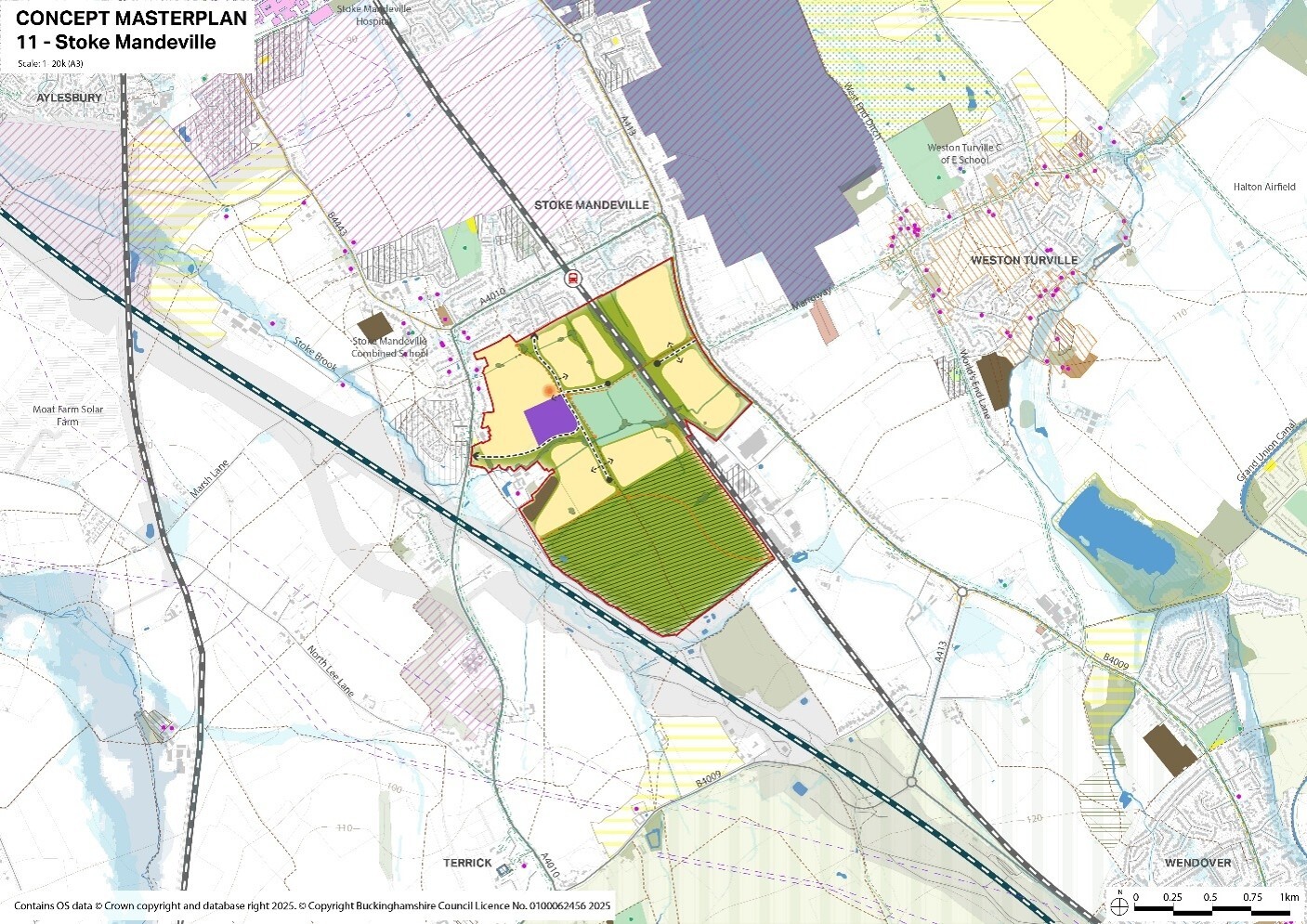
Stoke Mandeville NESS Site 011
6.118Land identified on the Policies Map and Indicative Diagram as Stoke Mandeville NESS011 comprises approximately 103.2 hectares of land to the south of Stoke Mandeville and is allocated as a strategic mixed-use urban extension, integrated with the existing settlement. The site represents a sustainable location for growth, adjacent to the existing built-up area and capable of delivering a comprehensively planned urban extension integrated with the existing settlement.
6.119The allocation will deliver a residential-led mixed-use development comprising a minimum of 1,650 dwellings within the Plan period, together with approximately 1,500 sq.m of town centre uses, supporting infrastructure, community facilities, and a network of green and blue infrastructure.
Site Context and Characteristics
6.120The site lies within the Vale of Aylesbury and comprises agricultural land. Its proximity to Stoke Mandeville railway station provides a significant opportunity to support sustainable travel patterns.
6.121The site is flat with a moderately open character and forms part of the wider setting of the Chilterns National Landscape.
6.122The site is influenced by major infrastructure, including the A413, railway infrastructure and the HS2 corridor, which create physical constraints and will influence the form and layout of development.
6.123Development has the potential to increase pressure on the surrounding area, particularly in relation to the transport network and local character.
Development Strategy and Design Approach
6.124The site will be developed as a comprehensively planned urban extension, with a strong emphasis on landscape-led design and integration with the existing settlement.
6.125Green infrastructure will form a key element of the development, using existing landscape features to structure growth and support biodiversity, recreation and flood risk management.
6.126Development will be focused on the railway station to maximise accessibility and encourage sustainable travel behaviour.
Infrastructure and Community Provision
6.127The scale of development requires provision of community infrastructure, including local centres, education and healthcare facilities.
6.128Healthcare provision will be informed by engagement with the Integrated Care Board and up-to-date evidence at the planning application stage.
6.129Development will also contribute towards off-site infrastructure where required.
Environmental Considerations and Mitigation
6.130Flood risk, including surface water flooding in parts of the site, will be managed through a risk-based approach and the integration of sustainable drainage systems.
6.131The presence of HS2 and railway infrastructure requires appropriate buffers and mitigation to ensure safe and acceptable living conditions.
6.132Heritage assets, including Stoke House, will be conserved and enhanced through careful design and layout.
6.133The site lies within the Chilterns Beechwoods SAC Zone of Influence and mitigation will be required through SANG and contributions to SAMM.
Transport and Movement
6.134The transport strategy is designed to mitigate impacts on the surrounding network while supporting sustainable travel.
6.135New infrastructure, including the South Spine Road, will provide key routes through the site.
6.136Improvements to the highway network, including connections to the A413 and Risborough Road, will be required.
6.137Sustainable transport will be prioritised, including improvements to the railway station, bus services and walking and cycling routes.
6.138A comprehensive walking and cycling network will connect the site to wider networks including the Aylesbury Gardenway and LCWIP routes.
Delivery, Masterplanning and Phasing
6.139Development will be delivered through a comprehensive masterplan and phasing strategy to ensure coordinated delivery.
6.140The masterplan will establish the spatial framework, infrastructure requirements and delivery sequence.
6.141A design code will be required to ensure high-quality and consistent development.
6.142Delivery will be monitored through the Council’s monitoring framework.
NESS012 - Winslow
Policy NESS012: Winslow NESS
- This 411.4 hectare site, as shown on the Policies Map, is located to the northeast and northwest of Winslow.
- The site is allocated for a strategic residential-led mixed-use development delivering a minimum of 9,370 dwellings, of which 3,650 will be delivered in the Plan period, including 15 net additional serviced Gypsy and Traveller pitches, approximately 16 hectares of employment land, around 3,500 sq.m of town centre uses within local centres, supporting infrastructure, and a comprehensive green and blue infrastructure.
Development Requirements
- Development proposals will be permitted where they accord with the requirements:
below and are supported by a comprehensive, site-wide masterplan and phasing strategy.
Place making and design.
- Development must adopt a landscape-led approach which:
- Responds positively to the site’s rural character and landscape setting.
- Retains and reflects historic field patterns, hedgerows and woodland; and
- Maintains the separation between Winslow and surrounding settlements, including Great Horwood.
- Development must create a high-quality, distinctive and functional place and must:
- Integrate with the existing town of Winslow and reinforce its role as a local centre.
- Retain and incorporate existing landscape features as part of a connected green infrastructure network.
- Respond to infrastructure constraints, including utilities corridors and sewage treatment works.
- Provide appropriate buffers to mitigate impacts on amenity and environmental assets.
- Address flood risk through layout, design and sustainable drainage systems; and
- Be informed by up-to-date environmental and technical evidence.
Movement and Connectivity
- Development must deliver a comprehensive movement strategy which prioritises sustainable transport and must:
- Provide new and improved connections to the surrounding highway network
- Provide a link road between A413 Buckingham Road and Great Horwood Road, and a link road between Great Horwood Road and Little Horwood Road
- Ensure infrastructure provision is informed by proportionate transport modelling and supports the safe operation of the network
- Integrate development with East West Rail infrastructure; and
- Mitigate impacts on the local and wider transport network.
- Development must:
- Enhance public transport provision, including rail accessibility and bus services; and
- Provide connections to Winslow town centre, the railway station and surrounding settlements.
- Not prejudice the delivery of East West Rail.
- Development must provide a comprehensive walking, cycling and Public Rights of Way network which:
- Retains and enhances existing PROW, including the North Buckinghamshire Way and Midshires Way.
- Provides new strategic active travel routes across the site; and
- Connects neighbourhoods to key services and facilities.
Community Facilities and Services
- Development must provide accessible community infrastructure, including:
- Local centres providing retail, employment and community use as accessible focal points.
- Land and building for four new primary schools (6-15).
- Land and buildings for two secondary schools.
- Primary healthcare provision or contributions to off-site facilities as agreed; and
- Indoor and outdoor sport, recreation and play facilities in accordance with Policy SE5.
- Retail provision must be of a scale and type that meets local needs and supports, and does not undermine, the vitality and viability of Winslow town centre.
Green and Blue Infrastructure
- Development must deliver a connected green and blue infrastructure network which:
- Integrates watercourses, flood risk areas, and environmental features.
- Enhances biodiversity and ecological connectivity; and
- Reinforces landscape character.
- Development must:
- Maintain strategic green gaps to prevent coalescence with nearby settlements.
- Incorporate flood risk areas and infrastructure corridors within green infrastructure; and
- Provide buffers around infrastructure such as sewage treatment works.
- Provide multifunctional green infrastructure including:
- Public open space
- Sustainable drainage systems
- Outdoor sports provision
- Walking and cycling routes
- Allotments.
Employment Land
- Development must:
- Deliver a coordinated and well-integrated employment area.
- Provide flexible employment space capable of adapting to changing business needs.
- Support access to jobs within the development; and
- Ensure integration with the wider transport network and settlement.
Implementation, Phasing and Delivery
- Development will only be permitted where it is supported by a comprehensive site-wide masterplan and phasing strategy.
The masterplan and phasing strategy must:
- Demonstrate coordinated delivery across the site.
- Demonstrate coordinated and comprehensive delivery of off-site necessary infrastructure.
- Show how each phase integrates with the overall design.
- Identify infrastructure delivery timing and triggers.
- Include mechanisms to avoid piecemeal development; and
- Ensure alignment with infrastructure evidence.
- Infrastructure provision must be informed by viability and deliverability considerations, to be agreed with the Council.
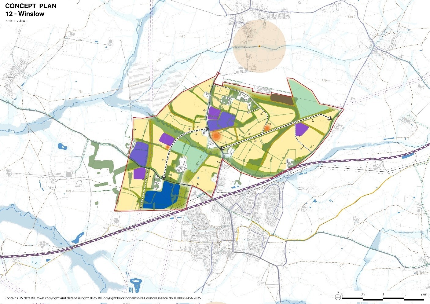
Winslow NESS Site 012
6.143Land identified on the Policies Map and Indicative Diagram as Winslow NESS Site 012 is allocated to deliver a strategic, mixed-use urban extension to Winslow. The site extends to approximately 411.4 hectares and will accommodate substantial growth, including residential development, employment land, local centres and supporting infrastructure.
6.144The allocation will deliver a minimum of 9,370 dwellings, of which 3,650 will be delivered in the Plan period, including fifteen net additional Gypsy and Traveller pitches, sixteen hectares of employment land and approximately 3,500 sq. m. of town centre uses within local centres, together with supporting community facilities and infrastructure.
6.145Development will be brought forward in phases, reflecting the scale and complexity of the allocation. A proportion of development is expected to extend beyond the Plan period.
6.146There were no extant planning permissions for dwellings on the site, as of June 2026.
Site Context and Characteristics
6.147The site lies to the northeast and northwest of Winslow within a rural landscape characterised by gently undulating farmland, historic field patterns and mature hedgerows, with areas of woodland providing ecological value.
6.148The northern and eastern parts of the site form part of a wider open landscape which contributes to the separation between Winslow and nearby settlements, particularly Great Horwood.
6.149The site is well served by a network of Public Rights of Way, including the North Buckinghamshire Way and Midshires Way, which provide opportunities for recreation and active travel.
Development Strategy and Design Approach
6.150Development has the potential to affect the surrounding area, including impacts on the transport network, infrastructure and landscape character.
6.151These impacts will be managed through a comprehensive master-planned approach, integrating development with East West Rail infrastructure and incorporating environmental mitigation.
6.152A key objective is to ensure that development is well integrated with Winslow, supporting the town centre and avoiding the creation of a separate settlement.
6.153Strong walking, cycling and public transport links will connect new neighbourhoods with the town centre and railway station, supporting linked trips and sustainable movement patterns.
Infrastructure and Community Provision
6.154The allocation provides an opportunity to deliver a major urban extension with housing, employment land and supporting infrastructure to create a sustainable community.
6.155The development includes provision of approximately sixteen hectares of employment land, supporting local economic growth and job creation.
6.156Community infrastructure, including local centres, education, healthcare and recreation facilities, will be delivered in accordance with the scale of development.
6.157Healthcare provision will be informed by engagement with the Integrated Care Board and updated evidence at the planning application stage.
Environmental Considerations and Mitigation
6.158Environmental and infrastructure constraints, including flood risk, utilities infrastructure and the sewage treatment works, will be incorporated into the design and layout of development.
6.159Appropriate buffers will be required to mitigate potential impacts on amenity and environmental assets.
6.160Flood risk areas will be integrated into the green infrastructure network, contributing to landscape and biodiversity enhancements.
Transport and Movement
6.161Development will increase demand on the local transport network, requiring mitigation to maintain safe and efficient operation.
6.162The transport strategy will include new infrastructure to the north of Winslow, improved connectivity and measures to promote sustainable travel.
6.163Integration with East West Rail will provide improved access to rail services and enhance connectivity.
6.164This allocation includes land safeguarded for East West Rail. Development will not be permitted within the limits of land subject to the safeguarding directions given by the Secretary of State for Transport in November 2025 (or any further directions or revisions to those directions) where it would conflict with or prejudice the delivery of EWR. Applicants for planning permission are strongly encouraged to enter early dialogue with EWR Co to fully understand the nature and extent of the safeguarding and the impacts on site development and to ensure that any scheme can be designed to reflect the safeguarding and that adverse impacts on EWR are avoided, minimised or appropriately mitigated.
6.165A comprehensive walking and cycling network will be provided, connecting the development to Winslow and surrounding areas.
Employment Land and Economic Role
6.166Given the scale of employment land proposed at Winslow, together with the planned population growth, the site presents a significant opportunity to support sustainable economic growth in northern Buckinghamshire. Its location adjacent to the new East West Rail station, proximity to the Silverstone Innovation and Enterprise Cluster, and position within the Oxford–Cambridge growth corridor, provide the potential to attract investment, support business growth and create highly accessible employment opportunities for existing and future residents.
6.167The allocation will contribute towards the ambitions of Buckinghamshire’s Economic Growth Plan by supporting productivity growth, increasing local employment opportunities and reducing the need for longer-distance commuting. The delivery of a range of modern and flexible employment premises, supported by high-quality digital and transport infrastructure, will help create an attractive location for both established businesses and new investment.
6.168The Council considers that Winslow is particularly well placed to support growth in a range of knowledge-intensive and high-value sectors that build upon Buckinghamshire's existing economic strengths and strategic clusters, including:
- Advanced Manufacturing and High-Performance Engineering.
- Film and Television and the Creative Industries.
- Space, Defence, Robotics and Autonomous Systems.
- Life Sciences and Health Technologies.
6.169The mix of employment uses should provide opportunities for businesses of different sizes and stages of growth, supporting innovation, inward investment and local job creation, whilst ensuring that employment development is integrated with the wider residential, community and transport infrastructure delivered through the allocation.
Delivery, Masterplanning and Phasing
6.170A coordinated and comprehensive approach will be required to deliver the development effectively.
6.171Development will be guided by a site-wide masterplan and phasing strategy, ensuring integrated delivery of land uses, infrastructure and mitigation.
6.172A design code will be required to secure high-quality and consistent design outcomes.
6.173Delivery will be monitored through the Council’s monitoring framework.
NESS013 – Turweston
Policy NESS013: Turweston NESS
- This 143 hectare site, as shown on the Policies Map, is located to the east of Brackley (Northamptonshire), adjacent to the Buckinghamshire boundary.
- The site is allocated for a residential-led mixed-use development delivering approximately 2,890 dwellings, together with five net additional serviced Gypsy and Traveller pitches, around 2ha of employment land, 2500sq.m. of town centre uses, and supporting infrastructure and community facilities and a comprehensive network of green and blue infrastructure.
Development requirements
- Planning permission will be granted where development accords with the requirements below and are supported by a comprehensive site-wide masterplan and phasing strategy:
Place making and design.
4. Development must adopt a landscape-led approach which:
- Responds positively to the rural character and landscape setting.
- Reflects existing field patterns, hedgerows and landscape features; and
- Integrates development sensitively into the wider countryside.
5. Development must establish a high-quality, distinctive and functional place and must:
- Retain and incorporate existing landscape features, including hedgerows and woodland.
- Provide appropriate buffers to the sewage treatment works.
- Safeguard land beneath overhead infrastructure for green infrastructure uses.
- Conserve and enhance the setting of Turweston Conservation Area.
- Manage flood risk through layout, design and sustainable drainage systems; and
- Be informed by up-to-date environmental and technical evidence.
6. Development should re-use existing buildings and features where they contribute positively to local character and where feasible and viable to do so.
Movement and connectivity
- Development must deliver a comprehensive movement strategy which prioritises sustainable transport and must:
- Provide access from the A422 and South Bank.
- Deliver connections to the surrounding highway network.
- Improve the A422 corridor and local junctions; and
- Ensure infrastructure provision is informed by proportionate transport modelling and supports the safe operation of the network.
- Development must:
- Address cross-boundary transport impacts in collaboration with relevant authorities; and
- Enhance public transport provision, including improvements to bus services.
- Development must provide a comprehensive network of walking, cycling, and Public Rights of Way which:
- Delivers new and enhanced routes across the site.
- Integrates and upgrades existing routes.
- Connects to the Buckinghamshire Greenway and wider network; and
- Provides strategic active travel connections to Turweston, Brackley and surrounding settlements.
Community Facilities and Services
- Development must provide a comprehensive range of community infrastructure including:
- Local centres providing retail, employment, and commune used as accessible focal points. Land and buildings for two primary schools (5FE total).
- Contributions towards off-site education provision.
- Primary healthcare provision or contributions to off-site provision as agreed; and
- Indoor and outdoor sport, recreation and play facilities in accordance with Policy SE5.
- Retail provision must be of a scale and type that meets local needs and supports, and does not undermine, nearby centres.
Green and Blue Infrastructure
- Development must deliver a multifunctional network of green and blue infrastructure which:
- Integrates woodland, hedgerows, watercourses and flood risk areas.
- Enhances biodiversity and ecological connectivity; and
- Reinforces landscape character.
- Development must:
- Provide buffers to HS2 and areas of Ancient Woodland.
- Safeguard land constrained by infrastructure and flood risk for green infrastructure uses; and
- Provide appropriate green infrastructure to support recreation and amenity.
- Development must provide multifunctional green infrastructure including:
- Public open space.
- Sustainable drainage systems.
- Walking and cycling routes.
- Outdoor sports provision; and
- Allotments.
Employment Land
- Development must:
- Deliver a coordinated and well-integrated employment area.
- Provide flexible employment space capable of adapting to changing business needs.
- Support access to jobs within the development; and
- Ensure integration with the wider transport network and surrounding areas.
Implementation, Phasing and Delivery
- Development will only be permitted where it is supported by a comprehensive site-wide masterplan and phasing strategy.
- The masterplan and phasing strategy must:
- Demonstrate coordinated delivery across the site.
- Show how each phase integrates with the overall design.
- Identify infrastructure delivery timing and triggers.
- Include mechanisms to avoid piecemeal development; and
- Ensure alignment with infrastructure evidence.
- Infrastructure provision must be informed by viability and deliverability considerations, to be agreed with the Council.
6.174Land identified as Turweston NESS Site 013 on the Policies Map, and the Indicative Diagram is allocated to deliver a residential-led mixed-use development. The site extends to approximately 143 hectares and is located to the east of Brackley and to the south of Turweston, close to the Buckinghamshire boundary.
6.175The development will deliver approximately 2,890 dwellings, including 5 Gypsy and Traveller pitches, alongside employment land, and approximately 2,500 sq. m. of town centre uses, community infrastructure and supporting services.
Site Context and Key Characteristics
6.176The site is agricultural, comprising a mix of arable and pastoral land within a rural landscape distinct from the build-up area of Brackley.
6.177It lies within a transitional landscape between higher ground around Brackley and Turweston and the lower-lying floodplain of the River Great Ouse.
6.178The River Great Ouse and its floodplain form key environmental features, supporting biodiversity and influencing development layout.
6.179The site is influenced by infrastructure, including the A43 to the west and the HS2 corridor to the east, which will require careful integration.
Development Strategy and Design Approach
6.180Development will be delivered as a comprehensively planned scheme, with a strong emphasis on landscape-led design and integration with its surroundings.
6.181Green and blue infrastructure will form a key element of the development, incorporate existing landscape features and support ecological enhancement.
6.182Development will also support local centres providing services and facilities to meet day-to-day needs.
Infrastructure and Community Provision
6.183The allocation includes provision of employment land, community facilities and local centres to support a sustainable and balanced community.
6.184Healthcare provision will be informed by engagement with the Integrated Care Board and the latest evidence at the planning application stage.
6.185Development will contribute towards off-site infrastructure where required.
Environmental Considerations and Mitigation
6.186Development must respond to site-specific constraints including the sewage treatment works, overhead power lines and areas of flood risk.
6.187Appropriate buffers and mitigation measures will be required to ensure acceptable living conditions and protect environmental assets.
6.188Flood risk areas will be integrated into the green infrastructure network as multifunctional open space.
Transport and Movement
6.189Development at Turweston will generate additional travel demand on the surrounding network, including the A422 corridor.
6.190The transport strategy will include new infrastructure, junction improvements and enhanced sustainable transport measures.
6.191Public transport improvements and a comprehensive walking and cycling network will support sustainable movement.
6.192Cross-boundary transport impacts will be addressed through collaboration with neighbouring authorities.
Employment Land and Economic Role
6.193The provision of approximately two hectares of employment land will support local economic activity and contribute to the creation of a balanced and sustainable community.
6.194Employment space should be flexible and capable of adapting to changing business needs, supporting businesses of different sizes and sectors.
6.195The integration of employment uses within the development will support local job creation and reduce the need for longer-distance commuting.
Delivery, Masterplanning and Phasing
6.196Development will be delivered through a coordinated masterplan and phasing strategy to ensure integrated delivery.
6.197A design code will be required to secure high-quality and consistent development.
6.198Delivery will be monitored through the Council’s monitoring framework.
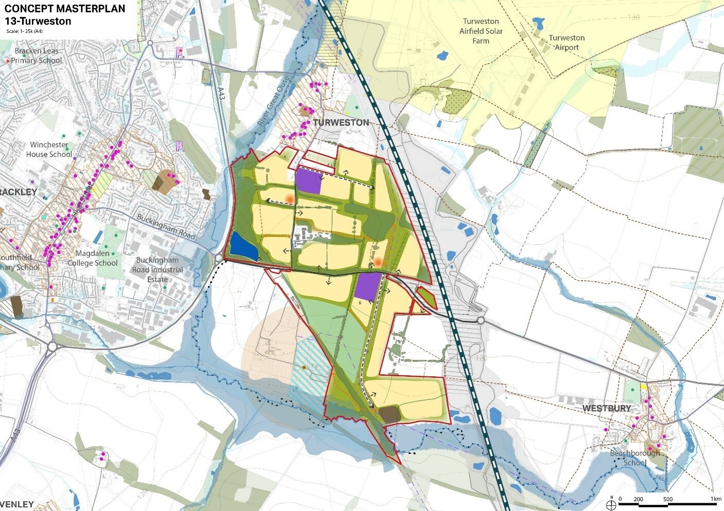
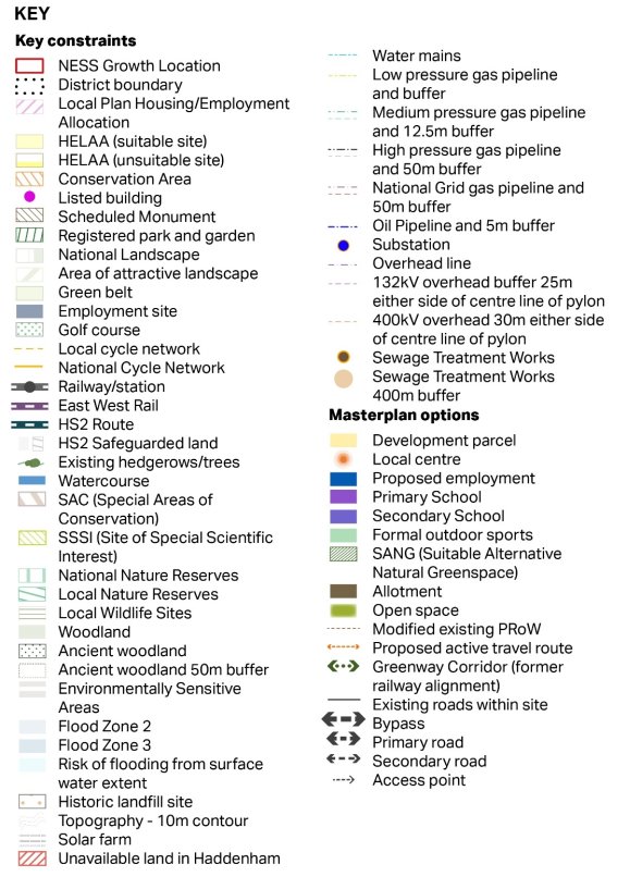
NESS015 - Beachampton
Policy NESS015: Beachampton NESS
- This 381.6 hectare site, as shown on the Policies Map, is in the north of Buckinghamshire, adjoining the boundary with Milton Keynes.
- The site is allocated for a new residential-led settlement, delivering a minimum of 8,230 dwellings, of which approximately 3,200 dwellings will be delivered within the plan period (to 2045), with the remainder delivered beyond the plan period. Development will include fifteen net additional serviced Gypsy/ Traveller pitches, approximately 2,500 sq.m. of town centre uses, community facilities and supporting infrastructure.
Development Requirements
- Planning permission will be granted where development accords with the requirements below and are supported by a comprehensive site-wide masterplan and phasing strategy:
Place making and design.
- Development must deliver a high-quality, landscape-led new settlement which:
- Responds positively to the site’s landscape setting, topography and rural character.
- Integrates development within the wider context of surrounding settlements; and
- Reflects existing field patterns, hedgerows and landscape features.
- Development must establish a distinctive, sustainable and self-supporting settlement and must:
- Retain and incorporate existing landscape features, including hedgerows and trees.
- Protect and enhance ecological assets, including Ancient Woodland with appropriate buffers and Local Wildlife Sites.
- Provide appropriate mitigation in relation to sewage treatment works, including buffers and odour mitigation.
- Respond to infrastructure constraints, including utilities and energy infrastructure.
- Manage flood risk through layout, design and sustainable drainage systems; and
- Maintain separation between Beachampton, Nash and Whaddon through strategic green gaps.
Movement and Connectivity
- Development must deliver a comprehensive movement strategy which prioritises sustainable transport and must:
- Provide a principal internal spine road network including the Thornton Road North Spine Road and internal circulation routes.
- Deliver the Whaddon Bypass.
- Provide connections to the surrounding network including Stratford Road and Nash Road; and
- Ensure infrastructure provision is informed by proportionate transport modelling and supports the safe operation of the network.
- Development must:
- Address cross-boundary transport impacts in collaboration with relevant authorities; and
- Enhance public transport provision, including bus services.
- Development must provide a comprehensive walking, cycling and Public Rights of Way network which:
- Connects neighbourhoods to local facilities.
- Retains and enhances existing PROW.
- Delivers new shared-use routes; and
- Provides strategic connections to surrounding settlements and LCWIP routes.
Community Facilities and Services
- Development must provide a comprehensive range of community infrastructure, including:
- Local centres providing retail and community uses as accessible focal points.
- Land and buildings for four primary schools (4-13FE total).
- Land and buildings for two secondary schools.
- Primary healthcare provision or contributions to off-site provision as agreed; and
- Indoor and outdoor sport, recreation and play facilities in accordance with Policy SE5.
- Retail provision must be of a scale and type that meets local needs and supports, and does not undermine, nearby centres.
Green and Blue Infrastructure
- Development must deliver a comprehensive green and blue infrastructure network which:
- Integrates watercourses, flood risk areas and environmental features.
- Enhances biodiversity and ecological connectivity; and
- Reinforces landscape character.
- Development must:
- Provide strategic green gaps to maintain separation between settlements.
- Protect and buffer ecological assets including Ancient Woodland.
- Integrate flood risk areas within green infrastructure; and
- Safeguard constrained land for green infrastructure uses.
- Development must provide multifunctional green infrastructure including:
- Public open space.
- Sustainable drainage systems.
- Outdoor sports provision.
- Walking and cycling routes; and
- Allotments.
Implementation, Phasing and Delivery
- Development will only be permitted where it is supported by a comprehensive site-wide masterplan and phasing strategy.
- The masterplan and phasing strategy must:
- Demonstrate coordinated delivery across the site.
- Demonstrate coordinated and comprehensive delivery of necessary off-site infrastructure.
- Show how each phase integrates with the overall design.
- Identify infrastructure delivery timing and triggers.
- Include mechanisms to avoid piecemeal development; and
- Ensure alignment with infrastructure evidence.
- Infrastructure provision must be informed by viability and deliverability considerations, to be agreed with the Council.
Beachampton NESS Site 015
6.199Land identified on the Policies Map and Indicative Diagram as Beachampton NESS Site 015 is allocated to deliver a new self-sustaining settlement in the north of Buckinghamshire. The site extends to approximately 381.6 hectares and will accommodate significant growth including housing, community uses and supporting infrastructure.
6.200The development will deliver a minimum of 8,230 dwellings, of which approximately 3,200 dwellings are expected within the Plan period, with further development extending beyond it. In addition, the site will also deliver 15 Gypsy and Traveller pitches, approximately 2.500 sq.m. of town centre uses, community uses and supporting infrastructure.
Site Context and Characteristics
6.201The site lies within a rural area characterised by agricultural land uses and the open clay vale landscape of north Buckinghamshire.
6.202The site is influenced by its landform, which slopes gently towards the north and is visually contained by surrounding ridgelines and vegetation.
6.203The River Great Ouse and associated watercourses create areas of flood risk and provide important ecological features.
6.204The landscape plays an important role in maintaining separation between Beachampton, Nash and Whaddon and preserving their individual identity.
Development Strategy and Design Approach
6.205Development will be delivered as a comprehensively planned new settlement, with a strong emphasis on landscape-led design and integration with surrounding settlements.
6.206Green and blue infrastructure will form a key component of the development, structure growth and supporting biodiversity, recreation and flood risk management.
6.207Local centres will provide services and facilities to meet day-to-day needs and reduce the need to travel.
Infrastructure and Community Provision
6.208The scale of development requires provision of a wide range of infrastructure, including education, healthcare and community facilities.
6.209Healthcare provision will be informed by engagement with the Integrated Care Board and up-to-date evidence at the planning application stage.
6.210Development will contribute towards off-site infrastructure where required.
Environmental Considerations and Mitigation
6.211Development must respond to environmental constraints including flood risk, ecological assets and landscape sensitivity.
6.212Appropriate buffers will be required around sewage treatment works and ecological features.
6.213Flood risk areas will be incorporated into the green infrastructure network.
Transport and Movement
6.214Development will generate additional demand on the local transport network, requiring mitigation to maintain safe and efficient operation.
6.215The transport strategy will include new strategic infrastructure, including spine roads and the Whaddon Bypass. Developers will be required to coordinate the delivery of these requirements.
6.216Sustainable transport will be promoted through enhanced bus services and walking and cycling infrastructure.
6.217Cross-boundary transport impacts will be addressed in collaboration with neighbouring authorities.
Delivery, Masterplanning and Phasing
6.218Given the scale and complexity of the allocation, a coordinated approach to delivery is essential.
6.219Development will be guided by a comprehensive masterplan and phasing strategy.
6.220A design code will be required to ensure high-quality and consistent development.
6.221Delivery will be monitored through the Council’s monitoring framework.
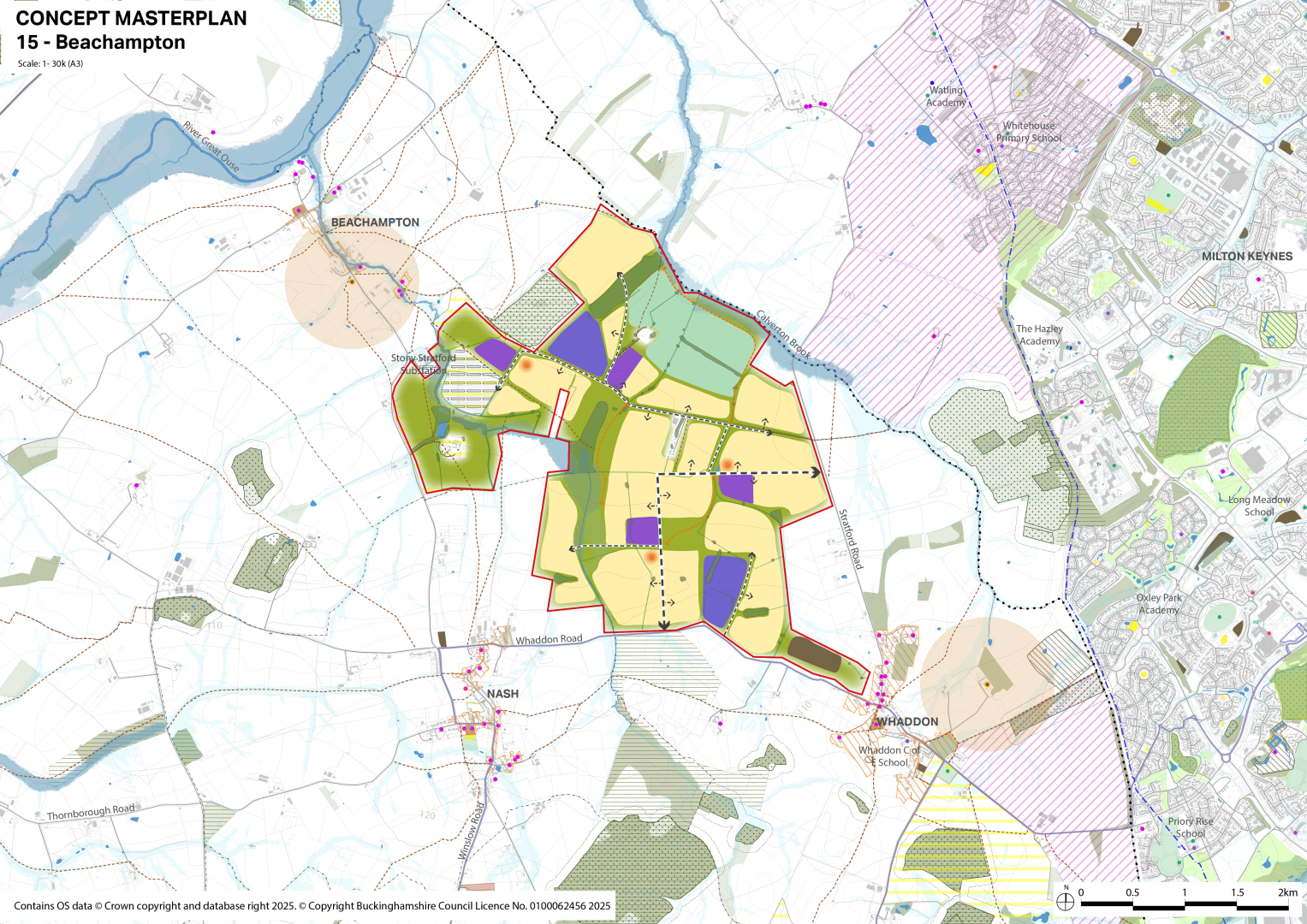
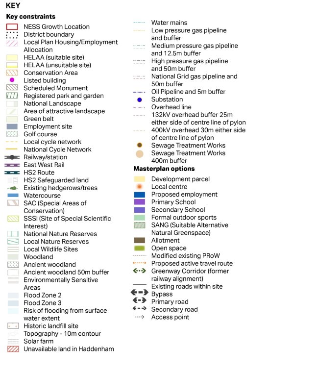
NESS018 - Wing
Policy NESS018: Wing NESS
- This 96 hectare site, as shown on the Policies Map, is located to the north-west of Wing, in north-east Buckinghamshire, close to the administrative boundary with Leighton Buzzard.
- The site is allocated for a residential-led mixed-use development delivering a minimum of 1,630 dwellings, all of which are expected to be delivered within the plan period, together with 5 net additional serviced Gypsy/ Traveller pitches, approximately 1,000 sq.m. of town centre uses, supporting infrastructure, community facilities and green and blue infrastructure.
Development Requirements
- Planning permission will be granted where development accords with the requirements below and are supported by a comprehensive site-wide masterplan and phasing strategy:
Place making and design.
- Development must adopt a landscape-led approach which:
- Responds positively to the site’s rural character and landscape setting.
- Reflects existing field patterns, hedgerows and landscape features; and
- Integrates development with the existing settlement of Wing.
- Development must establish a high-quality, distinctive and functional place and must:
- Retain and incorporate existing landscape features, including hedgerows and trees.
- Protect and enhance biodiversity, including provision of appropriate buffers to Local Wildlife Sites.
- Respond to infrastructure constraints, including provision of easements and buffers.
- Manage flood risk by avoiding development in areas of highest risk and incorporating sustainable drainage systems.
- Conserve and enhance the significance and setting of Wing Conservation Area; and
- Protect the Castle Hill Scheduled Monument and its setting.
- Development should re-use existing buildings and features where they contribute positively to local character and where feasible and viable to do so.
Movement and Connectivity
- Development must deliver a comprehensive movement strategy which prioritises sustainable transport and must:
- Provide the Wing North Spine Road and Wing West Link Road (Cublington Road to Stewkley Road).
- Deliver connections to Stewkley Road, Cublington Road and the wider network.
- Ensure infrastructure provision is informed by proportionate transport modelling and supports the safe operation of the network; and
- Mitigate impacts on the local and wider highway network.
- Development must:
- Address cross-boundary transport impacts in collaboration with relevant authorities; and
- Enhance public transport provision and accessibility.
- Development must provide a comprehensive walking, cycling and Public Rights of Way network which:
- Delivers new shared use routes.
- Retains and enhances existing PROW; and
- Provides strategic connections to Wing, Leighton Buzzard and surrounding settlements.
Community Facilities and Services
- Development must provide a comprehensive range of community infrastructure, including:
- Local centres providing retail, employment and community use as accessible focal points.
- Land and buildings for a primary school (2-3FE).
- Contributions towards off-site education provision.
- Primary healthcare provision, including contributions to expansion of existing GP services, as agreed; and
- Indoor and outdoor sport, recreation and play facilities in accordance with Policy SE5.
- Retail provision must be of a scale and type that meets local needs and supports, and does not undermine, existing centres.
Green and Blue Infrastructure
- Development must deliver a multifunctional network of green and blue infrastructure which:
- Integrates watercourses, flood risk areas and landscape features.
- Enhances biodiversity and ecological connectivity; and
- Reinforces landscape character.
- Development must:
- Provide Suitable Alternative Natural Greenspace (SANG) and Strategic Access Management and Monitoring (SAMMS) contributions in accordance with policies NE12 and NE13, and the latest Chilterns Beechwoods SAC Mitigation Strategy
- Provide buffers to protect ecological and heritage assets; and
- Safeguard land constrained by infrastructure or environmental features for green infrastructure uses.
- Development must provide multifunctional green infrastructure including:
- Public open space.
- Sustainable drainage systems.
- Outdoor sports provision.
- Walking and cycling routes; and
- Allotments.
Implementation, Phasing and Delivery
- Development will only be permitted where it is supported by a comprehensive site-wide masterplan and phasing strategy.
- The masterplan and phasing strategy must:
- Demonstrate coordinated delivery across the site.
- Demonstrate coordinated and comprehensive delivery of off-site necessary infrastructure.
- Show how each phase integrates with the overall design.
- Identify infrastructure delivery timing and triggers.
- Include mechanisms to avoid piecemeal development; and
- Ensure alignment with infrastructure evidence.
- Infrastructure provision must be informed by viability and deliverability considerations, to be agreed with the Council.
6.222Land identified on the Policies Map as Wing NESS Site 18 is allocated to deliver a residential-led mixed-use development adjoining Wing.
6.223The site provides an opportunity to accommodate growth for a comprehensively planned development that reflects the village’s distinctive character and setting, while delivering sustainable growth. The development will deliver a minimum of 1,630 dwellings, including 5 Gypsy and Traveller pitches, together with approximately 1,000 sq. m. of town centre uses and associated infrastructure and community facilities.
Site Context and Characteristics
6.224The site lies within a gently undulating agricultural landscape which contributes to the rural setting of Wing and the wider area.
6.225It contains established hedgerows, trees and field patterns which provide an important structural framework for development.
6.226The presence of heritage assets, including Wing Conservation Area and Castle Hill Scheduled Monument, adds sensitivity and requires careful consideration in the design of the development.
6.227Local Wildlife Sites to the north and east of the site further contribute to the ecological value of the site.
Development Strategy and Design Approach
6.228Development will be delivered as a comprehensively planned extension to Wing, with a strong emphasis on landscape-led design.
6.229Green infrastructure will form a key component of the development, providing ecological enhancement, recreation opportunities and landscape integration.
6.230Development will integrate with the existing settlement and respond to the site’s wider landscape setting and visibility.
Infrastructure and Community Provision
6.231The development will provide community infrastructure including local centres, education and healthcare provision to support a sustainable neighbourhood.
6.232Healthcare provision will be informed by engagement with the relevant Integrated Care Boards and the Council’s latest infrastructure evidence for the site at the planning application stage.
6.233Development will contribute towards off-site infrastructure where required.
Environmental Considerations and Mitigation
6.234Development must address environmental constraints including flood risk, ecological assets and heritage considerations.
6.235Appropriate buffers and mitigation will be required to protect Local Wildlife Sites and heritage assets.
6.236Flood risk will be managed through a risk-based approach and the incorporation of sustainable drainage systems.
Transport and Movement
6.237Development will increase demand on the local transport network and require mitigation to maintain safe and efficient operation.
6.238The transport strategy will include new infrastructure and improvements to existing routes.
6.239Sustainable transport will be prioritised through enhanced public transport provision and walking and cycling infrastructure.
6.240Connections will be provided to surrounding settlements including Leighton Buzzard.
Delivery, Masterplanning and Phasing
6.241Development will be guided by a comprehensive masterplan and phasing strategy to ensure coordinated delivery.
6.242A design code will be required to secure high-quality and consistent design outcomes.
6.243Delivery will be monitored through the Council’s monitoring framework.
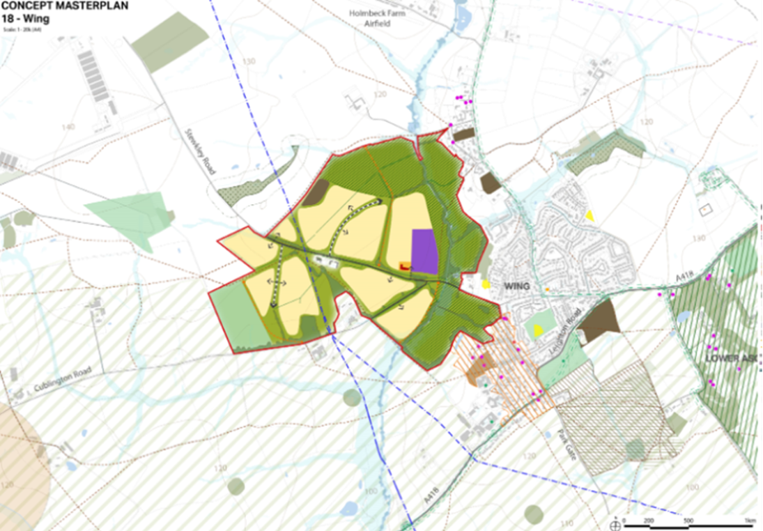
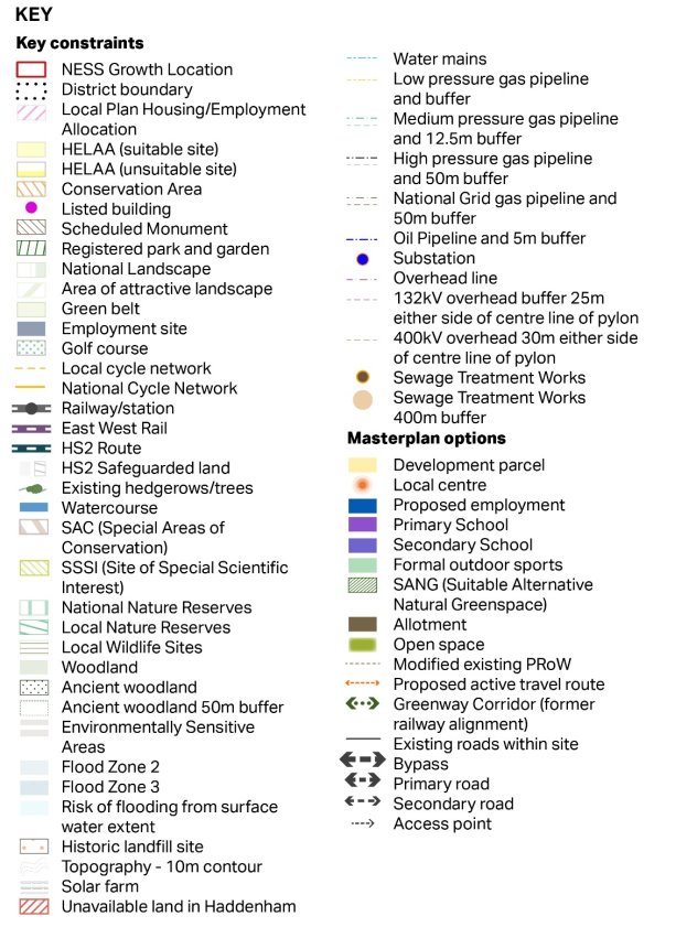
Housing Allocations over two hundred dwellings (including mixed use sites)
6.244Individual site policies are set out in this section. Sites have been allocated in accordance with the settlement hierarchy and are grouped according to the tier (Tier 1 to Tier 5) within which they are identified in the Settlement Review. The Settlement Review looks at all settlements in Buckinghamshire and places them in tiers according to the range of local services and facilities they have as well as looking at public transport availability, employment opportunities and distance from the nearest town. The aim is to understand how well residents’ everyday needs are met locally to help inform the level of sustainable growth which may be appropriate to those settlements. Tier 1 contains the major urban areas (High Wycombe and Aylesbury) while Tier 5 contains medium and small villages. There is also a Tier 6 which contains hamlets; however, no allocations have been made in this tier.
6.245All site allocations for 200 or more homes have a bespoke policy. Site allocations under 200 homes fall within appendix K to the plan and do not have a bespoke policy.
Tier 1:
- Aylesbury
- High Wycombe
- On the edge of Milton Keynes
AYL01 - South Aylesbury (AGT1)
Policy AYL01: South Aylesbury (AGT1)
Land Use Requirements:
The site as shown on the Policies Map is allocated for a comprehensively planned, mixed-use development.
Residential:
- The site will deliver approximately 1,350 dwellings, at a density that takes account of the adjacent settlement character and identify and supporting infrastructure.
- Provision of 5 Gypsy and Traveller pitches will be provided within the site.
Centre and Community Uses:
- A combined 2FE primary school will be delivered on site, including playing field provision and car parking.
- A new local centre will be delivered on site which will include retail and appropriate car parking.
- A new community building will be delivered on site which should provide for car parking and where there is a need, a ‘Touchdown’ facility for Thames Valley Police.
Green Infrastructure and Open Space:
- Multi-functional green infrastructure will be provided on site.
- Provide and maintain the management of 50% green infrastructure which links to other new development areas and the wider countryside as part of a high quality built and semi-natural environment.
Transport Infrastructure:
- Land is safeguarded for the delivery of the Aylesbury Southeast Link Road (SEALR) dual carriageway between A413 Wendover Road and B4443 Lower Road (now under construction) which will cross the railway line and provide sufficient land for associated works including but not limited to earthworks, drainage and structures.
- Deliver new access points into the development parcels from the B4443 Lower Road and A413 Wendover Road which minimise direct access from SEALR and supports cohesive development.
Development Principles:
- Development should integrate the new development with the existing built area of Aylesbury and Stoke Mandeville and responds positively to the best characteristics of the surrounding area.
- A landscape buffer should be provided between the new development and Stoke Mandeville where possible to maintain the setting and individual identity of the settlement of Stoke Mandeville.
- Retain the Grade II listed Magpie Cottage within an appropriate setting informed by Heritage Impact Assessment.
- A financial contribution should be provided for off-site primary healthcare facilities for the reconfiguration or expansion of an existing GP practice, or a new GP practice, in agreement with the Integrated Care Board (ICB).
- Retain where possible existing vegetation, including existing hedgerows.
- Retain and enhance existing habitats where possible, including the creation of linkages with surrounding wildlife assets and green corridors linking development with the wider countryside and surrounding communities.
- Suitable Alternative Natural Greenspace (SANG) and Strategic Access Management and Monitoring (SAMMS) contributions, in line with policies NE12, NE13, NE14 and the latest Mitigation Strategy. Permission will not be granted if appropriate mitigation is not provided.
- Designed using a landscape-led approach including consideration of the long-distance views of the Chilterns National Landscape and the field pattern and landscape features on the site.
- Provide detailed modelling to confirm 1 in 20-, 100-and 1,000-year extents and 1 in 100 years plus climate change extents on the ordinary watercourse (see SFRA Level 2 main report 2026).
- Have undertaken Surface water modelling to define the level of surface water risk and the risk areas/flow paths. Climate change should be modelled using the +40% allowance (February 2016) for rainfall intensity. A surface water drainage strategy should ensure that the development does not increase flood risk elsewhere.
- Seek to mitigate against potential surface water flooding of Stoke Mandeville Hospital
- Model the risk of overtopping or breach of the Aylesbury Arm (Grand Union Canal).
- Are designed using a sequential approach. Flood Zones 2 and 3, and 3a plus climate change (subject to a detailed flood risk assessment) should be preserved as green space. Built development should be restricted to Flood Zone 1.
- Design drainage which should be ‘designed for exceedance’ and accommodate existing surface water flow routes, with development located outside surface water flood areas.
- Provide proportionate financial contribution to the Southeast Aylesbury Link Road (SEALR) which will go towards repayment of the Housing and Infrastructure Fund.
- Access to and from the SEALR will not be supported unless it can be demonstrated that all other options, including taking access through neighbouring sites, are incapable of providing access to the northern land parcel from Lower Road.
- The site will deliver suitable walking and cycling routes to improve connectivity between the site and key destination including but not limited to Stoke Mandeville Railway Station and the hospital.
- Provide provision for public transport into the town and to surrounding areas.
- Integrate existing public rights of way into the development within safe and secure environments as part of a wider network of sustainable routes, to directly and appropriately link the site with surrounding communities and facilities.
6.246The site is approximately 92.8ha in size. Boarding the site is a variety of residential rear boundaries. In addition, the northwestern edge is with Stoke Mandeville Hospital, with car parking and rear facades of the hospital buildings predominating. The southern edge adjoining Stoke Mandeville village is mixed residential rear boundaries and some existing green spaces. The site is also bounded by Lower Road to the west and Wendover Road to the east. The topography of the site and surrounding area is flat which allows for views to the east and west which continue across open countryside.
6.247The site lies within Flood Zone 1 and is crossed by several ordinary watercourses and drainage ditches. Whilst no significant fluvial flood risk constraints have been identified across most of the site, detailed assessment and modelling of flood risk, surface water drainage and climate change impacts will be required to inform the design and layout of development. The site is currently in agricultural use and includes a network of hedgerows, ditches and other habitats which contribute to local ecological value. Ecological surveys have identified habitats and species that will require appropriate avoidance, mitigation and enhancement measures, including provision for ground-nesting birds and the retention and enhancement of habitat connectivity across the site.
6.248One public right of way exists across the site and uses a level crossing to cross the railway line. The site comprises of five parcels of land but have now been promoted as a single site for this local plan. These parcels are:
- Land around Red House Farm, Lower Road.
- Land north of Stoke Mandeville adjacent Lower Road.
- Land south of Aylesbury adjacent to Wendover Road.
- Land between the Aylesbury-Amersham railway line and Wendover Road; and
- Land straddling the Aylesbury-Amersham railway line north of Stoke Mandeville
6.249The five parcels are allocated together as the South Aylesbury (AGT1) to support a comprehensive and coordinated approach to development and infrastructure delivery. Although the parcels are physically separated by the Aylesbury-Amersham railway line and the Southeast Aylesbury Link Road (SEALR), they share common infrastructure, transport and green infrastructure requirements that are most effectively planned on an allocation-wide basis. This approach enables the cumulative impacts and infrastructure needs of the allocation to be addressed in a coordinated way, rather than through piecemeal development of individual parcels.
6.250Given the large number of smaller parcels that make up this allocation, an overall site masterplan is essential to ensure a co-ordinated and comprehensive approach to development, and to guide phasing of the site and infrastructure requirements. This must include a coordinated approach to vehicular access which will be achieved from the B4443 Lower Road and A413 Wendover Road and other infrastructure requirements.
6.251The Southeast Aylesbury Link Road (SEALR) forms an important piece of infrastructure serving the South Aylesbury (AGT1) allocation. The section of the SEALR that passes through the allocation (Phase 1) is currently under construction and is expected to be completed in late 2026. The wider SEALR scheme includes Phase 2, which opened in November 2025.
6.252Part of the site lies within the Zone of Influence of Chilterns Beechwoods SAC which affects the land to the east of the railway line and as such appropriate SANG and SAMM mitigation is required. It is anticipated that the site could secure credits at Kingsbrook Meadows strategic SANG. The access to the land to the west of the railway line would be off Lower Road, which is outside of the zone of influence, the land west of the railway line therefore would not be required to provide a SANG.
6.253There are applications pending consideration for housing, but also include a primary school, community hall, sports and local centre, covering different parcels of land within the allocation. A significant proportion of development is proposed within outline application 19/01628/AOP this application, for up to 650 dwellings, was submitted by in April 2019 for the land west of the railway line. The application is at an advanced stage of being considered by the council. A further application (23/01967/AOP) was submitted for up to five hundred dwellings in June 2023.
AYL02 - Land at southwest, Aylesbury (AGT2)
Policy AYL02: Land at southwest, Aylesbury (AGT2)
Land use requirements:
The site as shown on the Policies Map, is allocated for a comprehensively planned, mixed use development.
Residential:
- The site will deliver an assumed number of 1,400 dwellings at a density that takes account of the adjacent settlement character and identity.
- Provision of 5 Gypsy and Traveller pitches will be provided within the site.
Centre and Community Uses:
- Provision of land, building and car parking for one 2FE primary school will be delivered on site.
- Health facilities to be delivered on site.
- Community facilities, including an onsite community building will be completed.
- Play areas and Public Art to be provided on site.
Green Infrastructure and Open Space:
- A linear park
- Sports pitches
- Multi-functional green infrastructure
Transport and Flood Infrastructure:
- Construction of a Southwest Link Road between Stoke Mandeville relief road (SEALR Phase 2) and A418 Oxford Road.
- Development should safeguard land for the potential future need to dual the Southwest Link Road.
- Financial contribution towards the provision of SEALR Phase 2 roundabout to connect to the SWALR.
- Provision of public transport into the town and surrounding areas
- Strategic flood defences and surface water attenuation
- Development should be steered outside of areas within Flood Zone 2, 3a and 3b, as well as areas at risk of surface water flooding. Residential development is not permitted within Flood Zone 3b.
- Developers should utilise SuDS with multiple benefits throughout the site, particularly in areas at risk of surface water ponding.
- A detailed hydraulic model of the Sedrup Ditch may be required at FRA stage to accurately represent the risk from this watercourse and set the height of any mitigation measures.
- Blockage modelling should be conducted to assess the residual risk associated with potential blockage of the bridge structure over the Sedrup Ditch in the north of the site, and blockage of the culverts on the Stoke Brook beneath the railway line and Stoke Mandeville Relief Road.
Development Principles:
Development will be permitted where proposals:
- Are accompanied by the information required in the council’s Local Validation lists and comply with other relevant policies in the plan, including the principles of development for Aylesbury Garden Town.
- Are integrated with the existing built area of Aylesbury and respond positively to the best characteristics of the surrounding area to deliver a high quality built and semi-natural environment.
- Retain, where possible, existing vegetation including existing woodlands and hedgerows.
- Include a buffer and associated mitigation HS2 to reduce noise and other impacts on nearby residents.
- Retain and integrate existing public rights of way into the development as part of a wider network of sustainable routes, to directly and appropriately link the site with surrounding communities and facilities.
- The development should be designed using a landscape-led approach including consideration of the long-distance views of the Chiltern National Landscape, respond positively to the best characteristics of the surrounding area and reflecting the field pattern and mature landscape features on the site.
- Provide public transport into the town and to surrounding areas.
- The site will also provide flood alleviation to Stoke Brook through diversion of the brook and appropriate complementary measures, such as attenuation lakes. A detailed hydraulic model of the Sedrup Ditch may be required at FRA stage to accurately represent the risk from this watercourse and set the height of any mitigation measures.
- Consideration must be given at the detailed design stage to the layout, siting and landscaping to ensure appropriate standoff distances and operational access to the overhead National Grid transmission line from Amersham to East Claydon. The impact of the assets should be reduced through good design.
- Retention of a suitable setting for Grade II listed Hall End farm and Stoke Cottage
- Financial contributions towards, secondary school provision, and expansion of existing special schools
Design and Masterplan:
- Development at Land at Southwest Aylesbury should be brought forward in accordance with their existing planning consents and the Aylesbury Garden Town principles in Policy D1. Design should take account of the over-arching Garden Town principles to ensure a comprehensive development. The site should be a comprehensively planned development as well as demonstrating how the allocation links to and contributes to the delivery of the AGT overall.
6.254The site falls between Oxford Road, Standalls Farm, Princes Risborough Railway line and Aylesbury and has a site area of 113ha.
6.255The site was allocated in the Vale of Aylesbury Local Plan 2021 as two parcels as the site crosses the Aylesbury-Princes Risborough Railway. Outline planning permission was granted in May 2026 (18/04346/AOP) for mixed-use development including up to 1,400 residential dwellings providing a comprehensive development on both parcels AGT2. The site is expected to start construction in 2028 initially delivering fifty homes then 140 per annum.
6.256The site provides an opportunity for a sustainable extension integrated with, and supportive of, the existing community, bringing a wide range of benefits in a manner that makes the best use of existing resources and infrastructure.
6.257The site boundaries are defined by established hedgerows with occasional hedgerow trees. There are existing public footpaths which cross the fields to the west and south of the site. Two listed buildings are associated with Hall End Farmhouse and Stoke Cottage. Hartwell House historic park and garden and Hartwell conservation area and numerous listed buildings are located due west of the site.
6.258The HS2 route forming the southern boundary to the site could be a significant constraint and will have a potential effect on the developable area and mitigation. A noise buffer will be required which will reduce the developable area of the site. Delivery of access to the site will need to consider the differing levels between the realigned A4010 and the underpass of the Aylesbury to Princes Risborough railway line.
6.259There is an area of flood risk zone to the north of the site, from the Stoke Brook and surface water and groundwater flood risk as set out in the SFRA Level 2. Overhead power lines bisect the site to the south-west. The areas of the site in Flood Zones 2 and 3 and HS2 buffer zone will only be suitable for green infrastructure, a strategic link road and footpaths.
6.260There are existing hedges and mature trees including black poplars, and these features must be retained. Highways impact on Marsh Lane and sustainable transport options into Aylesbury need to be addressed.
6.261The southern access to this site is dependent on the delivery of new major infrastructure. The Southeast Aylesbury Link Road (SEALR) phase 2 has now been complete and is open. Access to the site from the south will need to be constructed off this.
AYL03 - Aylesbury north of A41 (AGT3)
Policy AYL03: Aylesbury north of A41 (AGT3)
Land Use Requirements:
Land North of A41, Aylesbury as shown on the Policies Map, is allocated for a comprehensively planned, mixed-use development. The allocation comprises three principal land parcels:
- Land at Manor Farm – approximately 29.1ha
- Aylesbury Woodlands – approximately 200ha (mixed-use including employment and residential)
- Land at College Farm – approximately 12.9ha
Residential:
- The site will deliver approximately 1,700 dwellings alongside supporting infrastructure and employment uses.
- In addition, sixty extra care units (Use Class C2) will be provided within the site.
Employment:
- Approximately 102,800 sqm of employment floorspace (Use Classes E(g), B2 and B8) will be delivered on site, including the delivery of the Aylesbury Woodlands Enterprise Zone
Centres and Community Uses:
- A local centre of approximately 4,000 sqm (Use Classes E, F1, F2 and sui generis uses) will be delivered on site.
- A two-form entry primary school (approximately 2ha, Use Class F1) is required to be delivered within the site.
- Approximately 6,000 sqm hotel and conference facility (Use Class C1) is to be provided on site.
Green Infrastructure and Open Space:
- Approximately 16ha sports village and pitches will be delivered on site.
- On site, a network of open space will be delivered which includes:
- Play space.
- Informal and formal open space
- Allotments/community orchards
- Woodland areas
- A minimum of 50% Green Infrastructure (GI) across the site
Transport and access:
- Development must provide primary access from the Eastern Link Road (South) and not rely on access from Broughton Lane. It should deliver strategic connections to the Eastern Link Road (ELR) and the A41 and provide high-quality active travel routes linking Aylesbury and surrounding areas.
- Development at Manor Farm will not be occupied until the ELR (South) is completed and open to traffic.
- Contributions will be required towards the ELR (South), including recovery of Housing and Infrastructure (HIF) investment.
Active Travel and Flood Infrastructure:
- Strategic link road connecting to the Eastern Link Road (North and South) and A41
- Walking, wheeling and cycling routes connecting to Aylesbury and surrounding areas.
- Land should safeguard land for the potential future need to dual key roads.
- Flood mitigation infrastructure including sustainable drainage systems (SuDS)
Employment and Economic Development:
Proposals must:
- Deliver the Enterprise Zone objectives and support tradeable activities within at least one of Buckinghamshire’s high-value sectors (as set out in the Buckinghamshire Economic Growth Plan) and can demonstrate significant potential to contribute to productivity growth.
- Demonstrate contribution to:
- Local supply chains
- Skills development and employment (in accordance with Policy EC3)
- Digital infrastructure and economic resilience
- Provide for the timely delivery of employment land, coordinated with residential development.
Safeguarding Employment Land
Existing and planned for employment land will be safeguarded. Alternative uses will only be supported where it is robustly demonstrated that:
- The employment use is no longer required or viable (see DM policy EC1); and
- The proposal would not undermine the delivery of the Enterprise Zone or wider Local Plan strategy.
Development principles:
Development will be permitted where proposals:
- Deliver a comprehensively planned garden community which is integrated with the existing built-up area of Aylesbury.
- Respect and maintain the separate identity and setting of Broughton.
- Respond positively to the Aylesbury Arm of the Grand Union Canal, the Chilterns National Landscape setting and existing landscape and settlement character.
- Provide a high-quality built and landscaped environment.
- Retain and enhance existing vegetation, hedgerows and woodland, public rights of way which are integrated into a safe and connected network and deliver green corridors linking the site to the wider countryside Developers should consider utilising the southern section of the site as a green corridor for flood mitigation.
- A detailed 1D-2D detailed hydraulic model of the unnamed ordinary watercourse in the southwest of the site, based on topographic survey of the watercourse channel, may be required at FRA stage to accurately represent the risk from this watercourse and set the height of any mitigation measures.
- The risk from surface water flow routes should be quantified as part of a site-specific FRA, including a drainage strategy, so runoff magnitudes from the development are not increased by development across any ephemeral surface water flow routes. A drainage strategy should help inform site layout and design to ensure runoff rates are as close as possible to pre-development greenfield rates, with areas of surface water ponding used as open space and SuDS or water compatible/essential infrastructure uses only.
- Seek to mitigate against potential surface water flooding of Stoke Mandeville Hospital
- Model the risk of overtopping or breach of the Aylesbury Arm (Grand Union Canal)
- Are designed using a sequential approach. Flood Zones 2 and 3 plus climate change (subject to detailed flood risk assessment) should be preserved. Built development should be restricted to Flood Zone 1 and avoid areas of surface water risk. Site design and making it safe must follow the SFRA Level 2 site summary sheet guidelines (2026).
- Conserve and enhance the setting of Broughton Manor Farm Barn (Grade II), the scheduled ancient monument to the south and adjacent buildings.
- Provide a landscape buffer to Broughton and sensitive heritage assets, a canal-side buffer along the northern boundary and farmland bird compensation habitat.
- Retain open land west of the ELR as a strategic buffer.
- Suitable Alternative Natural Greenspace (SANG) and Strategic Access Management and Monitoring (SAMMS) contributions in accordance with policies NE12 and NE13, and the latest Chilterns Beechwoods SAC Mitigation Strategy, provide biodiversity enhancement and habitat connectivity and ensure long-term management of green infrastructure.
Design and Masterplan:
Development will only be permitted where it is supported by a comprehensive and coordinated masterplan and phasing strategy for the entire site. This should be submitted to and approved by the Council prior to the determination of any planning application. The masterplan and phasing strategy must:
- Demonstrate how development will be brought forward in a coordinated manner to deliver an integrated and cohesive scheme.
- Show how each phase will contribute to and integrate with the design concepts of the development as a whole; and
- Ensure that development is supported by the timely provision of infrastructure, including highways, utilities and community facilities, in accordance with the Council’s most up-to-date evidence of infrastructure needs
6.262The three parcels of land which make up this site is approximately 242.6ha and located approximately two miles east of Aylesbury town centre.
6.263The overall site is surrounded by a mix of land uses including the Grand Union Canal Aylesbury Arm, the Bear Brook, agricultural buildings and residential properties in Broughton Hamlet and the planned Eastern Link Road. To the east, the site is bounded by College Road North and the commercial developments along this road, most notably the Arla processing dairy, and College Farm. Residential properties located near to the site are College Farm and The Red House to the east of the site off College Road North. The eastern portion of the site adjoining College Road North is included within the Arla/Woodlands Enterprise Zone designation which also extends over an existing employment area centred on the Arla dairy.
6.264Parts of the site falls within Flood Zone 2 and Flood Zone 3. Development needs to respond to the 2026 SFRA level 2 site summary sheet and guidelines for site design and making it safe for users. A satisfactory road access will need to be achieved once the Eastern Link Road on Woodlands has been delivered. In addition, the impact on heritage assets with Grade II* Listed Buildings and a Scheduled Monument which fall within proximity to the site should be considered and mitigated against.
6.265The site lies within the zone of influence of the Chilterns Beechwoods Special Area of Conservation (SAC). Development is likely to generate recreational pressure and will require appropriate mitigation. Planning permission will not be granted until suitable SANG and SAMM mitigation is secured, in accordance with Policies NE12, NE13 and NE14 and the latest mitigation strategy. It is anticipated that suitable SANG could be delivered on-site. Alternatively, provision may be secured through the purchase of credits at the Kingsbrook Meadows strategic SANG if delivery on site cannot be achieved.
6.266The employment element of the site is a strategic employment area for Buckinghamshire as it includes the Aylesbury Woodlands Enterprise Zone, which is intended to support the growth of high-value, knowledge-based sectors and to attract investment into Buckinghamshire. The Enterprise Zone provides an important opportunity to deliver modern, high-quality employment floorspace and to support innovation, productivity and job creation in key sectors of the local economy.
6.267Ensuring the timely delivery of employment development alongside residential growth is essential to achieving the Local Plan’s objectives of providing sustainable communities, reducing the need to travel, and supporting economic resilience. The policy therefore requires proposals to demonstrate how employment provision will be brought forward in an appropriate relationship with the wider development, including through effective phasing arrangements.
6.268The policy also seeks to maximise the wider economic benefits arising from the development, including supporting local supply chains, enhancing skills and employment opportunities for residents, and contributing to the delivery of digital infrastructure. These measures are important in ensuring that the development contributes positively to Buckinghamshire’s long-term economic strategy.
6.269Given the strategic importance of the site, it is necessary to safeguard the approved employment floorspace from being lost to non-employment uses. This will ensure that the site continues to deliver its intended economic function over the plan period and supports the role of the Enterprise Zone. Proposals that would reduce or delay the delivery of employment development will therefore only be supported in exceptional circumstances, where it can be clearly demonstrated that the approved employment use is no longer required or deliverable, and that the overall objectives of the Local Plan would not be undermined.
6.270The current planning status of the site is as follows: Land at Aylesbury Woodlands outline planning application granted (16/01040/AOP). This included an illustrative masterplan. Various reserved matters have also been approved. No applications received on the remainder of the site.
AYL04 - South of A41, Aylesbury (AGT4)
Policy AYL04: South of A41, Aylesbury (AGT4)
Land Use Requirements:
Land South of A41, Aylesbury as shown on the Policies Map, is allocated for a comprehensively planned, mixed-use development. The allocations comprise two principles land parcels:
- Hampden Fields – Approximately 218ha
- Land at New Road, Weston Turville – Approximately 1.7ha
Residential:
- The site will deliver approximately 3,000 dwellings at a density that takes account of the adjacent settlement character and identity. The development should be integrated with the existing build area of Aylesbury, and maintain the settings, individual identity and character of Stoke Mandeville and Weston Turville
- In addition, sixty bed care homes/extra care facility will be provided within the site.
Employment:
- Approximately 6.90ha of employment land will be delivered on site.
Centres and Community Uses:
- Provision of land, building and car parking for two primary schools each with a pre-school, a children’s centre on one of the primary school sites will be provided on site.
- A mixed-use local centre with associated parking will be provided on site, including temporary community buildings if necessary.
- Provision of an on-site health facility. Where it is justified provision for expansion or an alternative larger site may need to be identified and secured for a multipurpose health facility to accommodate further growth and service demand to increase capacity.
Green Infrastructure and Open Space:
- Multi-functional green infrastructure totalling 108.34ha will be provided on site.
- Suitable Alternative Natural Greenspace (SANG) and Strategic Access Management and Monitoring (SAMMS) contributions, in line with policies NE12, NE13, NE14 and the latest Mitigation Strategy. Permission will not be granted if appropriate mitigation is not provided.
Transport and Flood Infrastructure:
- On-site land provision will be safeguarded for a park and ride site.
- Strategic flood defences and surface water attenuation should be provided to mitigate flood risk.
- A dualled Southern Link Road between A413 Wendover Road and A41 Aston Clinton Road and a strategic link road between the Southern Link Road and Marroway Cycling and walking links should be provided within the site.
Development Principles:
Development will be permitted where proposals:
- Are accompanied by the information required in the council’s Local Validation lists and comply with other relevant policies in the plan, including the principles of development for Aylesbury Garden Town.
- Provide a financial contribution to support secondary school provision, and the expansion of existing special school.
- Retain where possible existing vegetation and landscape features, including field patterns, existing woodlands and hedgerows.
- Retain and integrate existing public rights of way into the development as part of a wider network of sustainable routes, to directly and appropriately link the site with surrounding communities and facilities utilising green corridors.
- Retain and enhance existing habitats where practicable, including the creation of linkages with surrounding wildlife assets. This includes the wildlife area within Bedgrove Park.
- Are designed using a landscape-led approach including consideration of the long-distance views of the National landscape and respond positively to the best characteristics of the surrounding area.
- Provide for cycleways, footpaths and public transport connections into the town and to surrounding areas.
- Provide town-wide flood defences through a flood alleviation system benefitting the wider community and provision of sustainable drainage system (SuDS) will be required to reduce pressure on the existing drainage network.
- Provide and maintain management of 50% green infrastructure to link to other new development areas and the wider countryside.
- Have undertaken detailed modelling to confirm flood zone and climate change extents. The Environment Agency and lead local flood authority should be consulted to obtain the latest hydraulic modelling for the site at the time of the flood risk assessment. They will advise as to whether existing detailed models need to be updated.
- Have investigated residual risk to the site and reservoir flood risk to the site, for example overtopping or breach of the Weston Turville Reservoir
- Have modelled the impact of blockage of structure(s) under Aston Clinton Road and on Bedgrove Road.
- Have undertaken surface water modelling to define the level of surface water risk and the risk areas/flow paths. Climate change should be modelled using the +40% allowance (February 2016) for rainfall intensity. A surface water drainage strategy should ensure that the development does not increase flood risk elsewhere.
- Designed using a sequential approach. Flood Zones 2 and 3 and 3a plus climate change (subject to detailed flood risk assessment) as shown on the policies map as “areas of not built development” should be preserved as green space with built development restricted to Flood Zone 1.
- Have designed new major transport infrastructure such as the Southern Link Road so that the potential loss of floodplain and change of flow pathways resulting from their implementation do not have an adverse effect on flood risk. They should also be designed to ensure that they remain operational and safe for users in times of flood.
- Drainage designs should ‘design for exceedance’ and accommodate existing surface water flow routes, with development located outside of surface water flood risk areas.
Design and Masterplan
- Development at Hampden Fields and Land adjacent to the Holiday Inn should be brought forward in accordance with their outline planning consent and the Aylesbury Garden Town principles in Policy D1. Design should take account of the over-arching Garden Town principles to ensure a comprehensive development. The site should be a comprehensively planned development as well as demonstrating how the allocation links to and contributes to the delivery of the AGT overall.
6.271South of A41, Aylesbury is a strategic allocation for Aylesbury and contributes to the delivery of Aylesbury Garden Town. It has a site area of approximately 225.5ha. The allocation comprises the following sites:
- Land at Hampden Fields – outline planning permission was granted for 3,000 dwellings and 46,800 sqm of employment. This included an illustrative masterplan. There have been several reserved matters applications approved, and work has commenced on site. This site will form a vital urban extension to Aylesbury, integral to the town’s Garden Town status.
- Land adjacent to Aston Clinton Holiday Inn – completed 121 dwellings.
- Land at New Road, Weston Turville – allocated for fifty-one dwellings.
- Land east of New Road, Weston Turville – completed sixty-four dwellings.
- Land Bounded by New Road and Aston Clinton Road – completed 135 dwellings.
6.272One of the reasons for merging the sites is to enable a more comprehensive approach to development in this area, and to improve co-ordination and location of infrastructure and services. The site provides an opportunity for a sustainable extension integrated with, and supportive of, the existing community, bringing a wide range of benefits in a manner that makes the best use of existing resources and infrastructure.
6.273To the south of the site lies the village of Weston Turville, separated from the site by Weston Turville Golf Club and agricultural land. To the north are Bedgrove and Bedgrove Park, and to the east the A41 Aston Clinton Road. Immediately to the west is the Hampden Hall residential development and the south-western edge of the site runs parallel with Wendover Road abutting short, sections of the road, housing and fields to the rear of housing.
6.274Current land use is agricultural land (a mixture of Grade 3a and 3b quality), mostly arable fields but with some pasture fields in the northern part of the site. There is an historic field pattern that varies from east to west: fields are defined by hedgerows with occasional trees. The site also supports one small plantation in its southern part, one small copse of amenity woodland in its northern part and one field in its western part that comprises rough grassland, emerging woodland and a collection of fruit and other ornamental trees.
6.275The site is dissected by the unclassified New Road which runs south-north between Weston Turville and the A41 Aston Clinton Road. There are two public footpaths within the site.
6.276The watercourses of Bedgrove Brook and West End Ditch run through the site and Wendover Brook passes alongside the south-eastern site boundary. There are also several drainage ditches within the site. The site is located outside of the settlement boundary of Aylesbury in open countryside. It has no other policy designations in the adopted Local Plan.
6.277The current planning status of the site is as follows:
- Land at Hampden Fields outline planning application granted (16/00424/AOP). This included an illustrative masterplan which has been agreed. Various reserved matters have also been approved.
- Land adjacent to Aston Clinton Holiday Inn has two pending applications: an outline application for 108 dwellings (16/03388/AOP) and a full application 121 dwellings (18/02495/APP). The full application for 121 dwellings (18/02495/APP) is the most up to date application.
- Land east of New Road, Weston Turville is now complete.
- Land Bounded by New Road and Aston Clinton Road is now complete.
6.278Land Bounded by New Road and Aston Clinton Road and Land east of New Road were both completed at the end of 2019. Land at Hampden Fields is projected to come forward between 2023 and 2033 and the remainder of the ‘Aylesbury south of A41’ site is expected to deliver between 2022 and 2027. Careful consideration needs to be given to phasing and co-ordination of the delivery of the whole site.
6.279To ensure a comprehensive approach to development, consideration should be given to how the sites relate to each other and to ensure the sites take account of one another.
6.280Infrastructure will be provided alongside development – details to be determined through site discussions.
6.281The site lies within the zone of influence of the Chilterns Beechwoods Special Area of Conservation (SAC). Development is likely to generate recreational pressure and will require appropriate mitigation. Planning permission will not be granted until suitable SANG and SAMM mitigation is secured, in accordance with Policies NE12, NE13 and NE14 and the latest mitigation strategy. It is anticipated that suitable SANG could be delivered on-site.
AYL05 - Kingsbrook (AGT6), Aylesbury
Policy AYL05: Kingsbrook (AGT6), Aylesbury
Size (hectares) 306.6ha
Allocated for (key development and land use requirements)
- 2,460 homes
- 10ha employment
- Two primary schools
- A neighbourhood centre
Construction of the southern section of the Eastern Link Road (North) with safeguarding of land for future duelling if required and the rural section of the Stocklake Link Road
- Green Infrastructure
- A major wetland park
- Flood alleviation scheme/sustainable drainage.
- Community facilities
- Play areas.
- Land for a secondary school, sports pitches and allotments
- Town-wide flood defences
- Health facilities
- Public art
- Improvements to the canal towpath
Proposals should comply with the following criteria:
- Provision for land for at least 2,460 dwellings at a density that takes account of the adjacent settlement character and identity.
- Provision of land, building and car parking for two primary schools and land for a secondary school
- Existing vegetation should be retained where practicable, including existing woodlands and hedgerows. Existing public rights of way need to be retained and integrated into the development within safe and secure environments as part of a wider network of sustainable routes, to directly and appropriately link the site with surrounding communities and facilities.
- Proposals must retain and enhance existing habitats where practicable, including the creation of linkages with surrounding wildlife assets. A new wetland park should be provided.
- The development should be designed using a landscape-led approach including consideration of the long-distance views of the AONB as well as of potential landscape visual impact from the AONB.
- Provision for public transport into the town and to surrounding areas.
- A flood alleviation system benefitting the wider community and provision of sustainable drainage systems (SuDS) will be required to reduce pressure on the existing drainage network.
- Provision and management of 50% green infrastructure to link to other new development areas and the wider countryside. This should incorporate recreation and sports facilities, public open space, play areas, allotments and orchards, sustainable drainage, nature reserves and ecological enhancement areas, education/interpretation facilities, and attractive pedestrian and cycle routes to the town centre.
- Provision of on-site health facilities and community buildings
- Provision of and contribution to infrastructure as appropriate.
- A traffic calming scheme to the village of Bierton
Implementation Approach
An illustrative masterplan was submitted as part of the outline panning application granted in 2013, a strategic design code and area design codes have been approved, to guide the comprehensive development of the site. Three villages already have reserved matters approved planning applications. Construction is already under way to develop the site in accordance with the planning permissions, the approved development brief and principles within Policy D1 and any subsequent supporting Garden Town. Design should take account of the over-arching Garden Town principles (policy D1) and details within the Aylesbury Garden Town Framework and Infrastructure guidance document to ensure comprehensive development.
6.282‘Kingsbrook, Aylesbury’ is a major urban extension on the eastern side of Aylesbury on 306ha of land between Bierton and the Aylesbury Arm of the Grand Union Canal.
6.283Outline planning permission was granted in December 2013 for 2,450 homes, 10ha employment land, a neighbourhood centre, two primary schools, construction of the Eastern Link Road (northern part) and the Stocklake Link Road (rural section), green infrastructure including a major wetland park, associated community facilities and support infrastructure including an expanded electricity substation and flood defences. Construction for Land to a new secondary school to the north of the site has been constructed. A further application (22/03289/APP) has been approved for 21 dwellings (an additional 10 dwellings provided in lieu of health facilities as part of the local centre). Total dwellings to be provided from this site are 2460.
6.284The housing development is based on the principle of creating three villages within the overall framework of the site. As of March 2025, reserved matters have been approved for all the site with 1,922 dwellings complete and 538 dwellings remaining to come forward. Key elements of transport infrastructure including the Eastern Link Road and Stocklake Link have been complete.
6.285The site is expected to be complete by 2028. The status of the three villages is as follows:
- Village 1 Canal Basin development – complete
- Village 2 - Oakfield – detailed permission for 492 dwellings (14/03486/ADP) and is now complete.
- Village 3 - Canal Quarter for 1,097 dwellings –
- Phase 1 for 228 dwellings (18/01153/ADP) is now complete.
- Phase 2a for 383 dwellings (19/01732/ADP) is under construction.
- Phase 2b for 110 dwellings and the neighbourhood centre (19/02983/ADP) under construction and complete
- Phase 3 for 212 homes (20/00740/ADP) approved and implemented.
- Phase 4 for 164 dwellings and the employment area (19/04426/ADP) approved and implemented19/02983/ADP under construction and nearly complete.
- Village 4 - Orchard Green – detailed permission for 861 dwellings (15/01767/ADP) and under construction
6.286The site is located immediately to the east of Aylesbury. It extends from Oakfield Road in the west and to the south runs to the Grand Union Canal with a small area of the site extending to the other site of the canal towards Broughton. To the east is Aylesbury Golf Centre (driving range) as well as open countryside/agricultural fields. To the north lies the village of Bierton with the application site joining the A418 to the north-east. There is an existing substation towards the centre of the site which is excluded from the red edge but a series of overhead power cables that are within the site. The land prior to development was entirely in arable cultivation. Ground levels on-site vary from approximately 87m above ordnance datum (AOD) to 78m AOD.
6.287There are settlements with different identities and settings to be reinforced – Bierton, Broughton, Hulcott and the edge of Aylesbury.
6.288Significant remodelling of the flood zones on the site took place with mitigation measures as part of the outline planning application. Most of the site is drained via Broughton Brook, an EA designated ‘main river’ watercourse which is a tributary of Stocklake Brook. The Stocklake Brook watercourse drains the northern catchment area of the site as well as the Broughton Brook catchment. The area immediately to the south of the Grand Union Canal (GUC) is part of the Aylesbury Flood Alleviation Scheme (AFAS) and drains into Bear Brook, which runs south of the site adjacent to the southern side of the GUC.
6.289The site has numerous flora and fauna, and a comprehensive scheme of ecological enhancements was required as part of the planning permission.
6.290The site includes some heritage assets including historic routes of way. Most hedges and historic routeways across the site will be retained within the development. The Grand Union Canal runs to the south of the main areas of development and has several listed and non-listed bridges along this stretch.
AYL06 - Land to the north of Martin Dalby Way, Aylesbury
Policy AYL06: Land to the north of Martin Dalby Way, Aylesbury
Land use Requirements:
Land to the north of Martin Dalby Way, as shown on the Policies Map, is allocated for a comprehensively planned, mixed use development.
Residential:
The site will deliver an assumed 3,150 homes at a density that responds positively to the character and identity of adjoining communities and accords with the principles of Aylesbury Garden Town.
Centre and Community Uses:
- Provision of land, buildings and car parking for new local centre
- Provision of land, buildings and car parking for a 3FE school form of entry primary school
- Community hall/ facilities including flexible community meeting space.
- Financial contribution towards or the delivery of a healthcare facility either by way of site provision or direct funding (including temporary buildings if necessary).
- Equipped play facilities and informal recreation space.
- Public art integrated throughout the development.
Green Infrastructure and Open Space:
- Multi-functional green infrastructure comprising at least 50% of the gross site area, including:
- public open space.
- sports pitches.
- allotments and community orchards.
- sustainable drainage features.
- ecological enhancement areas.
- pedestrian and cycle routes; and
- areas for informal recreation.
- Measures to protect and enhance the black poplar population south of Martin Dalby Way.
- Enhancements to the Aylesbury Linear Park.
Transport and Flood Infrastructure:
- Requirements for off-site highway mitigation and assessment
- The site layout should adopt a sequential approach by steering the most vulnerable aspects of the development outside Flood Zone 2, 3a and 3b and areas at risk of surface water flooding. Residential development is not permitted within Flood Zone 3b.
- Flood alleviation scheme/sustainable drainage.
- Hydraulic modelling is required to inform a planning application to assess the potential flood risk from Hardwick Brook and Weedon Ditch, including the existing footbridges along these watercourses, in the event of a blockage. Development should be steered outside the areas of fluvial and surface water flood risk on site.
- Access to form an internal route through the site allowing for internal vehicular connectivity.
- Deliver a new linear park active travel route (Martin Dalby Central Green Route).
Development principles:
Development will be supported where proposals:
- Are accompanied by the information required in the council’s Local Validation lists and comply with other relevant policies in the plan, including the principles of development for Aylesbury Garden Town.
- Retain existing trees/ tree groups and hedgerows, where possible, along boundaries, stream corridor along Hardwick Brook.
- The development should provide measures to integrate with the existing built-up area of Aylesbury (including Berryfields and Buckingham Park).
- Retain and integrate existing public rights of way into the development as part of a wider network of sustainable routes, to directly and appropriately link the site with surrounding communities and facilities.
- Retain and enhance existing habitats where practicable, including the creation of linkages with surrounding wildlife assets.
- Are designed using a landscape-led approach including consideration of the views from the Quainton-Wingrave ridge to the north, the Chilterns National Landscape to the southeast as well as of potential landscape visual impact from the National Landscape.
- Site to facilitate access by a north Aylesbury bus service connecting to the town centre and public transport options.
- Deliver enhancements to the Aylesbury Linear Park.
- Provide a flood alleviation system benefitting the wider community and provision of sustainable drainage systems (SuDS) to reduce pressure on the existing drainage network.
- Provide and maintain management of 50% green infrastructure which should link to other new development areas and the wider countryside. This should incorporate recreation and sports facilities, public open space, play areas, allotments and orchards, sustainable drainage, nature reserves and ecological enhancement areas, education/interpretation facilities, and attractive pedestrian and cycle routes to the town centre.
- To mitigate the effects of the development on the continued grazing of the Quarrendon Scheduled Ancient Monument.
- Set out a traffic calming scheme to prevent through traffic from accessing the A413.
Design and Masterplan:
Development on the Land to the north of Martin Dalby Way should be brought forward in accordance with the Aylesbury Garden Town principles in Policy D1 and taking account of the Aylesbury North NESS site and masterplanning for that site. Design should take account of the over-arching Garden Town principles to ensure a comprehensive development. The site should be a comprehensively planned development as well as demonstrating how the allocation links to and contributes to the delivery of the AGT overall.
6.291The site comprises approximately seventy-nine hectares of agricultural land located on the northern edge of Aylesbury. The site forms part of the open countryside separating Aylesbury from surrounding rural settlements and is characterised by a series of agricultural fields, grassland and hedgerows. The site occupies an elevated and open position, resulting in extensive views from the surrounding area and towards the site. An existing wind turbine is located within the wider area; the land associated with this use has been excluded from the allocation. The site is bounded by Hardwick Brook to the west, Berryfields to the south-west, Martin Dalby Way to the south and open countryside to the north and east.
6.292Access points could be achieved both from the northern side of Martin Dalby Way, and from the northwestern side of the farm track, extending between Martin Dalby Way and the A413 (Aylesbury to Whitchurch).
6.293Hardwick Brook, a Main River, forms much of the western boundary of the site. An additional ordinary watercourse runs along the south-western boundary before discharging into Hardwick Brook. Parts of the site are affected by fluvial flooding associated with these watercourses, particularly along the western and southern boundaries. Areas of surface water flood risk also occur across the site, following existing drainage channels and lower-lying land. Detailed hydraulic modelling and flood risk assessment will be required to inform the masterplanning, layout and drainage strategy for the allocation.
6.294The Quarrendon Scheduled Monument is located immediately south of Martin Dalby Way. Development proposals will need to conserve the significance of this nationally important heritage asset, including its setting, and ensure that appropriate measures are implemented to maintain its long-term management and continued grazing regime.
6.295Due to its open and elevated nature, the site is visible from a wide range of surrounding locations, including Martin Dalby Way, the A413, public rights of way and higher ground to the north. A landscape-led design approach will therefore be required to minimise visual impacts and integrate development into the wider landscape.
6.296There are several existing bus routes in the area that link the western or eastern boundaries of the site to Bicester, Waddesdon, Aylesbury and Buckingham. These include the 4/4a and 4e which run between Aylesbury, Quarrendon and Berryfields, including stops at Aylesbury Train Station. To the east of the site the sixty bus runs between Aylesbury and Buckingham. Bus routes 16 and 167 run between Aylesbury via Berryfields to Waddesdon to Calvert Green and the number 17 bus runs between Aylesbury, Berryfields, Quarrendon and Bicester.
6.297The allocation forms an important component of the continued delivery of Aylesbury Garden Town and will be expected to contribute towards the creation of a connected network of neighbourhoods, green infrastructure, sustainable transport connections and community facilities. Development should be planned comprehensively and in coordination with adjacent allocations and existing communities to ensure the creation of a sustainable urban extension.
AYL07 - Friarscroft Car Park, Aylesbury
Policy AYL07: Friarscroft Car Park, Aylesbury
The site as shown on the Policies Map is allocated for an assumed 300 dwellings.
New development will be supported where it:
- delivers a well-designed high-density scheme that makes good use of a brownfield site. To deliver this, the proposal should explore lower provision of car parking spaces. is supported by proportionate evidence of existing and future public car parking demand, including utilisation levels and appropriate alternative provision. Proposals should demonstrate that public car parking is either underused or can be appropriately re-provided, managed or offset.
- Proposals should also demonstrate how the development would utilise and improve sustainable travel options, taking account of the Council’s Parking Standards for New Development set out in Appendix I of the Local Plan.
6.298Friarscroft car park is in the west of Aylesbury town centre and close to the train station. The site is currently a multi-storey public car park, and any redevelopment of the site will need to demonstrate that parking can be re-provided, managed or offset at other town centre car parks or that the site is underused. Redevelopment of the site would need to complement the surrounding regeneration areas as well as being comprehensively developed with the neighbouring site - 3467 Aylesbury Multi-Cultural centre.
AYL08 – The Gateway, Aylesbury
Policy AYL08: The Gateway, Aylesbury
The site as shown on the Policies Map is allocated for mixed use development comprising 4000sqm floorspace in main town centre uses and office distributed across units of various sizes and an assumed 1,455 dwellings. The site will also include new public realm and should explore lower provision of car parking spaces.
New development will be supported where:
- It introduces mixed, culture and leisure-led town centre uses, complimenting adjacent sites.
- The land uses enhance the town centre’s historic character and appearance, vitality and viability, maximising the site potential.
- Opportunities are taken to enlarge the existing public realm, incorporate public art and potential for landmark buildings that reduce the impact of tall buildings in the design of upper floors.
- Public realm and green infrastructure are designed to integrate mature trees on the north and east boundary.
- Public realm connections as part of an Aylesbury Transport Strategy and links to the town centre are enhanced.
- Car parking is provided efficiently using the land for town centre uses and dedicated space for residential and employment uses. The car parking needs for this site should consider the accessibility of this site to other forms of transport, walkability and take opportunities presented for housing to be car-free.
- It incorporates measures to reduce surface water flooding on the site in line with the latest SFRA Level 2
- It sustains or enhances diverse town centre uses and customer choice incorporating residential accommodation above ground floor level where possible.
- The development is readily accessible by public transport, walking, cycling and wheeling.
Design and Masterplanning
A site Masterplan should be submitted to the council early in the planning application process, consistent with the latest Aylesbury Garden Town Masterplan. The Masterplan should be agreed as part of the planning application. As well as the site uses in this policy, the masterplan should also cover the following:
- Opportunities for landmark buildings, maximising site density with building heights having regard to the site context.
- The design of development to reduce the impact of buildings heights on the upper storeys.
- Public realm and streets should be well defined by built form, with buildings surrounding space does not space surrounding buildings.
- Incorporate design features reflecting the town history and nearby mixed-use sites.
- Infill surface parking integrated around buildings and public space.
- Introduce ground level active frontages to Gatehouse Road and Bicester Road and boulevard tree planting.
- Improve pedestrian links across Gatehouse Road towards the town centre and across Bicester Road, towards facilities to the north.
- Review ways to enhance the built environment and pedestrian permeability towards Goldswain End to the west.
6.299The site is a 20.6ha brownfield site which sits within the built-up area of Aylesbury. It currently resides the Council offices and surface level car parking. It has good public transport connections and is a 20-minute walk to Aylesbury Train Station. The site is adjacent to a supermarket to the east, employment and residential to the south, and residential to the west and north.
6.300The site is currently under-utilised and unconstrained and given its brownfield status and it being within a highly sustainable location, the site provides a good opportunity to deliver a significant amount of both high-quality housing and town centre uses. The affordable housing contributions will be subject to viability testing. The development of the site should seek to make best use of land and enhance the character of the area.
AYL09 - Exchange Street Carpark, Aylesbury
Policy AYL09: Exchange Street Carpark, Aylesbury
The site as shown on the Policies Map is allocated for mixed use development comprising 2000sqm floorspace in main town centre uses and 2000sqm office distributed across units of various sizes and around 450 homes. The site will also include new public realm and 150 car parking spaces.
New development will be supported where:
- It introduces mixed, culture- and leisure-led town centre uses, complimenting adjacent sites. Development should sustain or enhance diverse town centre uses and customer choice incorporating residential accommodation above ground floor level where possible.
- The land uses enhance the town centre’s historic character and appearance, vitality and viability, maximising the site potential.
- It provides active frontages responding to the nearby Exchange development, Exchange Street and that relate well to High Street.
- Opportunities are taken to enlarge the existing public realm, incorporate public art and potential for landmark buildings that reduce the impact of tall buildings in the design of upper floors.
- Enhancements are delivered to the setting of the Listed Buildings in Market Square and Aylesbury Conservation Area informed by a Heritage Impact Assessment.
- Public realm and green infrastructure are designed to integrate and enhance St Josephs Church
- It enhances Exchange Street public realm, connections as part of an Aylesbury Transport Strategy and links to the Waterside South development. Development should enhance existing public spaces at Exchange Square, and pedestrian links connecting Market Square, Walton Street, Exchange Street and High Street. In addition, development should also enhance connections to public transport and the active travel network.
- Car parking is provided efficiently using the land for town centre uses and dedicated space for residential and employment uses. The car parking needs for this site should consider the accessibility of this site to other forms of transport, walkability and take opportunities presented for housing and offices to be car-free.
- Incorporate measures to reduce surface water flooding on the site in line with the latest SFRA Level 2
- Line of mature Horse Chestnut trees to Exchange Street need retaining with a sufficient buffer.
Design and Masterplanning
A site Masterplan should be submitted to the council early in the planning application process, consistent with the latest Aylesbury Garden Town Masterplan. The Masterplan should be agreed as part of the planning application. As well as the site uses in this policy, the masterplan should also cover the following:
- Opportunities for landmark buildings, maximising site density with building heights related to the context.
- The design of development to reduce the impact of buildings heights on the upper storeys.
- Public realm and streets should be well defined by built form, with buildings surrounding space, not space surrounding buildings.
- Incorporate design features reflecting the town history and nearby mixed-use sites.
- Infill surface parking integrated around buildings and public space.
- Introduce ground level frontages to Exchange Street and boulevard tree planting.
- Continue design features in the active frontages of the nearby Exchange development.
- Mitigate steep level change between Exchange Street and Hale Leys.
- Improve pedestrian links across Exchange Street to Waterside Theatre and Grand Union Canal, and to Cambridge Street.
- Review ways to enhance the built environment and pedestrian permeability of Hale Leys, through enhancement or redevelopment.
- Maintain and enhance the viewing corridors to landmark buildings including the Waterside Theatre, the Exchange and town centre heritage buildings.
6.301The existing site is primary used as a public car park. It is adjacent to Hale Leys Shopping Centre, High Street shops and services, the Exchange Street Road and ‘The Exchange’, an entertainment and leisure quarter of Aylesbury Town Centre. The site has been used a surface car park since the demolition of a multi-storey car park and Civic Centre around 2010.
6.302The site is part of the ‘Waterside North’ opportunity area is town centre planning and most recent Aylesbury Garden Town Masterplan (2020). This also includes the established Exchange development and the Odeon cinema, Wetherspoons pub restaurant and other public realm areas around the surface car park up to Hale Leys Shopping Centre. In addition to these, the site is adjacent a new walkway to a regeneration project, Pavillion Quarter off High Street and other active frontage uses on High Street.
6.303The site is highly visible from vantage points within the town centre and Waterside South. The site has significant footfall and presents the opportunity to repurpose public car parking elsewhere in the town. The site has a very high level of accessibility without needing a car. There are significant opportunities for a development on this site to help economic growth in the town centre with a range of town centre uses and employment generating uses. Like the established Exchange development adjacent, the site presents an opportunity for town centre living in high quality accommodation helping to meet local housing needs.
6.304The site has constraints due to being located near the heart of the town centre with noise, footfall, cross town views and walking routes to maintain and hard surfacing. There is also topography, replacing the existing car park and Exchange Street is as a barrier to pedestrian and cycle movement. There are also flooding constraints with surface water flooding in the middle of the site and heritage constraints including the nearby Aylesbury Conservation Area and several Listed Buildings – Grade II star County Hall and Judges Lodgings, Market Square, 32-36 Market Square and a footpath right of way (route 24/1). There are several large established trees on the site within green space fronting Exchange Street. These constraints do not prevent the development from coming forward and the redevelopment of this site would be required to address and mitigate against these constraints. Residential development would require contributions toward health, education, sports, open space, transport and other contributions.
6.305The site is part of the Aylesbury Central Area in the Aylesbury Garden Town Masterplan (2020, since revised). The AGT Masterplan for the Central Areas aims to continue and strengthen Aylesbury town centre's role as Buckinghamshire’s county town and civic centre. It will also create a town centre which is exemplary for its inclusive public realm that is safe, well-designed and accessible for all with an attractive arrival experience and first impression of the town centre. This site as part of the Central Area can also help support employment provision in the town, retail, the mix of uses and evening economy. In urban design terms, the site can help to increase physical health, access to the canal, enhance nearby heritage assets and be sensitive to the historic street pattern, scale and townscape.
6.306Waterside North and South are already transforming into a cultural hub. This site allocation is one of the later phases of the scheme which aim to add quality public spaces and civic and community uses into the town centre and enhance town centre linkages with the Grand Union Canal and Bear Brook.
6.307The area is identified in the AGT Masterplan as an opportunity for town centre redevelopment and falls within the Waterside North Action Plan which aims to enhance the retail, food and beverage, and housing offer in the town centre, strengthen links and help rejuvenate neighbouring areas.
AYL10 - Royal Mail Delivery Office, Aylesbury
Policy AYL10: Royal Mail Delivery Office, Aylesbury
- The site as shown on the Policies Map is allocated for an assumed 80 dwellings and 420 sqm of town centre retail uses.
- New development will be supported where:
- A proposal reflects the adjacent building heights and be appropriate in scale. All building should reflect a contemporary design to accord with the local distinctiveness.
- The development is based on a design brief, submitted as part of an application, to be prepared for the site which will need to reflect the local distinctiveness of its specific locality within Aylesbury.
- Landscaping is retained and incorporated as a buffer due to the site's relationship with neighbouring uses.
- The site allocation should be accessed via singular vehicular access point off Upper Hundreds Way. The existing access off Upper Hundreds Way roundabout will need to be modified and upgraded to include a fourth arm to provide sufficient access to the site.
- A proposal provides for an alternative ‘at-grade’ crossing adjacent to the existing subway between Britannia Street and Cambridge Street to provide a secondary access. The existing pedestrian crossing to the north of Hampden House should be relocated to the north-west to be directly opposite Railway Street. The scheme should incorporate additional street planting along the boundaries.
- Incorporate cycle and pedestrian connections into existing active travel networks.
- The site has had previous activity that may suffer from contamination. The council will expect an investigation to be undertaken and demonstrated as part of any application and, if necessary, the submission of decontamination proposals with any planning application.
- An ecological assessment for birds and bats should be undertaken for the building.
- A noise assessment is submitted to and approved in writing by the Council prior to development commencing
6.308The site is just over 1ha and is located adjacent to the town centre, bounded by the Upper Hundreds Way dual carriageway to the south, Cambridge Street to the west, housing to the north and car parking and a B&Q superstore to the east. The site comprises of a large two-storey 1960s office block that houses the Royal Mail and its associated car parking. The site also comprises a larger car park with a single unit site that is ancillary to the main Royal Mail building.
AYL11 - Hale Leys Shopping Centre, Aylesbury
Policy AYL11: Hale Leys Shopping Centre, Aylesbury
- The site as shown on the Policies Map is allocated for mixed use development comprising of 4,821sqm of employment, 4,821sqm of retail and an assumed 220 dwellings.
- New development will be supported where:
- A provision of mixed, retail and leisure-led town centre uses are provided, complimenting adjacent sites. In particular.
- Development will provide for 4,821sqm of retail E(a) and E(b) on the ground floor with good place making design and.
- Provision of 4,821sqm of employment consisting of E(g)(i) and E(g)(ii)
- Land uses will enhance the town centre’s historic character and appearance, vitality and viability, maximising the site potential.
- Active frontages are provided responding to the nearby Exchange development, Market Square and the High Street.
- They deliver any enhancements to the setting of the Listed Buildings in Market Square and Aylesbury Conservation Area informed by a Heritage Impact Assessment.
- Enhancement to the public realm connections linking Market Square, Exchange Street and High Street is delivered.
- Connections to public transport and the active travel networks are enhanced.
- The development is based on a design brief, submitted as part of an application, to be prepared for the site which will need to reflect the local distinctiveness of its specific locality within Aylesbury. The design brief will need to comply with principles of development for Aylesbury Garden Town and ensure that the proposed development meets the required design principles based on recognised good practice.
- A provision of mixed, retail and leisure-led town centre uses are provided, complimenting adjacent sites. In particular.
6.309Hale Leys Shopping Centre is approximately 0.6ha and is one of two shopping centres within Aylesbury Town Centre which contain large retail units, as well as offering food and beverage provision. The site has been identified as one of the key sites of opportunity within the Aylesbury Regeneration Strategy which states an excellent central location for retail and leisure facilities. Development of this site should include residential apartments above with commercial units on the ground floor.
6.310Given its central location within the town centre any redevelopment of the site will need to be designed in a manner that promotes good place making for town centres. This will be through having active frontages, and connections through, to Market Square, the Exchange and the High Street. Incorporate design features reflecting the history of the town and comprehensively designed with surrounding redevelopment sites. Reprovision of the retail on the site is vital to ensure a vibrant town centre.
HIW01 - Gomm Valley and Ashwells, High Wycombe
Policy HIW01: Gomm Valley and Ashwells, High Wycombe
Land at Gomm Valley and Ashwells, High Wycombe as shown on the Policies Map is allocated for a residential-led mixed use development.
Residential:
- The site will deliver an assumed 646 dwellings.
Employment:
- 1.2ha of employment land will be delivered on site to the west of the Peregrine Business Park
Centre and Community Uses:
- Provision of land and buildings for a 1 FE primary school and early years at the southern end of the site will be delivered on site.
- associated Community Uses.
Transport Infrastructure:
- Vehicular access into and through the site will be delivered which will include a link / spine road designed to minimise and distribute the impact of additional traffic on the existing local road network.
- The site will provide for bus access through the site. It will also provide internal active travel network including connections to Ashwell fields development to the North.
Development Principles:
Development will be permitted where proposals:
- Adopt a landscape - led design approach to the development of the site. This should recognise the intrinsic character and beauty of the hillside landform, whilst accommodating opportunities for development.
- Establish an appropriate urban edge to High Wycombe and Tylers Green and avoid the coalescence of the two settlements, leaving an undeveloped gap of at least two hundred metres at their closest point, informed by landscape impact, ecological requirements and character issues.
- Establish a strong sense of place with a distinctive attractive and functional living environment through a sensitive design response to the local context including topography, landscape, habitats and ecology.
- Pay regard to the landscape character and views of the area from the south, including mitigating unavoidable impacts in a way that respects the existing landscape character.
- Retain undeveloped areas of the valley to deliver both ecological and recreational benefits alongside each other whilst at the time respecting the valley’s landscape character.
- Conserve and enhance existing nature conservation interests and green infrastructure and facilitate the provision of new habitats.
- Minimise the effects of severance and disturbance on existing and proposed habitats caused by access and development.
- Retain and provide appropriate buffers to designated sites and valuable habitats within the site and beyond the site boundary to limit adverse effects from development.
- Maximise opportunities for habitat creation and connectivity as outlined in the Gomm Valley Biological Opportunity Area (BOA) description with an emphasis on the creation, restoration and management of lowland chalk grassland, woodland, lowland meadows and hedgerows to create a resilient habitat network within the site that connects well with networks beyond the site boundary;
- Provide a sustainable management framework, to be secured via legal agreement, for the delivery and ongoing maintenance of the undeveloped area including new and retained chalk grassland habitat.
- Deliver a significant net gain in biodiversity that reflect the site’s existing nature conservation interest and its designation as a Biodiversity Opportunity Area (BOA).
- Provide directly or make appropriate contributions to off-site transport works, including, but not limited to:
- Capacity improvements at the Gomm Road junction.
- Improvements to the northern end of Cock Lane
- Contribution towards a wider A40 package.
- Provision of an attractive shared use pedestrian / cyclist / equestrian route through King’s Wood, using existing private tracks and public bridleways to connect Cock Lane with the A404 Amersham Road (at the Beech Tree Pub).
- Off-site footpath and cycleway provision.
- Improved pedestrian crossing facilities.
6.311There are permitted applications for the site - PL/25/2353/FA at Gomm Valley for a residential led mixed-use development, and 24/07240/REM at Ashwells (for 106 dwellings). It is acknowledged that higher housing numbers may be achievable on areas of the site which have planning permission for residential development where a high quality innovative and bespoke architectural response is adopted and/or a higher proportion of smaller dwellings form part of the mix.
6.312If a new outline permission is sought for more than four hundred dwellings, a bespoke architectural response would need to be robustly proven at application stage with detailed parameter plans and detailed illustrative supporting documents and plans. All these indicative capacities remain subject to the proviso that they are to be treated as neither maxima nor minima in the planning application process.
6.313The Council has worked closely with local stakeholders and landowners to produce a development brief for the site. This was adopted in July 2017 and should be used as a starting point to inform any planning application submitted for the future development of the site.
6.314The site occupies a prominent and sensitive location and there are several long and near distance views of the site. The site is very close to, and within the setting of the Chilterns National Landscape. Development proposals need to reflect both the prominent location and the character of the landscape to create a place that is sensitively positioned in the landscape. A key issue that development proposals also need to address is maintaining the physical separation between High Wycombe and Tylers Green, through the provision of an undeveloped area of land on the eastern side of the allocated area which should be used and managed as a key piece of green infrastructure. The amount of land that is left undeveloped has been identified through consideration of the landscape, the character and existing green infrastructure on this side of the site.
6.315There are several existing nature conservation designations within the area which need a very sensitive design response:
- Gomm Valley SSSI
- Gomm Valley Local Wildlife Site
- Gomm Wood Local Nature Reserve
- Pimms Grove Ancient Woodland
- Little Gomm’s Wood Ancient Woodland
6.316Parts of the site are also covered by the Gomm Valley Biodiversity Opportunity Area Statement which provides a breakdown of the different habitats on the site. Buffers to Ancient Woodland and SSSI should be applied as per other policies in this Plan. These buffers are to be free of any development, including gardens. These distances would only be reduced if there was a clear and compelling case that this would result in overriding benefits to the scheme.
6.317There is a real opportunity for the undeveloped parts of the site to be managed in the future to achieve significant biodiversity benefits, including the reinstatement of chalk grassland.
6.318This site contains surface water flood risk area, which should be assessed and mitigated for in accordance with DM Policy CC1.
6.319The Gomm Valley is an attractive landscape and as such development proposals need to reflect this through the consideration of:
- The extent of the development parcels.
- The height and massing of development.
- The development’s relationship with the topography.
- The development’s impact on wider views (both into and out of the site); and,
- The integration of structural planting in both the developed and undeveloped areas of the site.
6.320The combination of landscape sensitivity, significant areas of nature conservation designations and the importance of avoiding coalescence between High Wycombe and Tylers Green mean the developable area of the site may be severely restricted. The adopted development brief for the site provides the starting point for informing the areas of the site that should be undeveloped and retained to respect landscape character and delivering ecological and recreation benefits.
6.321Traffic modelling identified the need for a road through the site, which should be a spine road linking Cock Lane and Gomm Road, to connect the site into the wider road network along with several off-site transport works including for bus provision. The purpose of this spine road is to distribute traffic from the development. It is not intended to act as an unofficial ‘bypass’ as this would be detrimental to Penn and Tylers Green due to the increase in through traffic. The capacity of the spine road and the northern end of Cock Lane must therefore be restricted through effective traffic calming to deter through traffic.
6.322There are several of opportunities provided by the development to enhance pedestrian and cycle links, green infrastructure and habitats both on and off the site.
6.323In assessing whether severance effects of access and development have been minimised, the following tests will be used:
- Are there suitable alternative routes or areas for development?
- Is the severance essential to deliver other sustainability benefits, such as public transport.
- Does the overall improvement to the quantity and quality of wildlife and biodiversity of the site, including its future management sufficiently mitigate for the harm caused?
6.324Wycombe is characterised by small pockets of employment land across the urban area. The site has permission for 1.2ha of employment given its location next to Peregrine Business Park. However, it is noted that the conversion of Peregrine Business Park to residential has been granted. If the conversion comes forward, the Council will consider any future applications at Gomm Valley and Ashwell’s if employment is suitable in this location in accordance with policies SP4 and EC2.
6.325The infrastructure assessment for the Plan has identified the need for supporting strategic open space and education facilities, for the sites on the north side of the town. However, due to the topography of the Gomm Valley site, and the need to maximise housing delivery, it is not suitable to accommodate all the formal open space needs on site. These will be accommodated at Terriers, where the topography is flatter (see HW7). Instead, this site is to accommodate a new primary school.
6.326The Infrastructure Delivery Plan sets out several of detailed transport measures that have been identified as being required as part of the planned growth. Development of this site should contribute towards to the provision of these measures along with any other infrastructure requirements specified in the IDP or future transport strategy for the town.
HIW02 - Land at Terriers Farm, Kingshill Road, High Wycombe
Policy HIW02 – Land at Terriers Farm, Kingshill Road, High Wycombe
Land at Terriers Farm and Terriers House as shown on the Policies Map is allocated for a comprehensive residential led development.
Land Use Requirements:
Residential:
- The site will deliver an assumed 410 dwellings at a density that takes account of the adjacent settlement character and identity.
Green Infrastructure and Open Space:
- High quality sport and recreation hub linking to the adjacent playing fields and facilities at Hazlemere Recreation Ground will be provided on site. This hub should include changing facilities. Vehicle access will need to be gained from the development site to new parking and changing facilities.
Development Principles:
Development will be permitted where proposals:
- Maintain the physical separation between the current built up area of Hazlemere and the development by locating the sports pitches within the site as an extension to the Hazlemere Recreation Ground.
- Integrate the historic Terriers Farm barns.
- Retain and enhance the pond and its environs.
- Retain the main North-South hedgerow, which has an adjacent public footpath, as the major green link through the site.
- Retain a green link between King’s Wood in the south and the Chilterns National Landscape countryside to the north to retain its function as a wildlife corridor.
- Retain the field boundaries within the site.
- Provide a commensurate financial contribution secured by planning obligation to enable the delivery of the proposed school on the Gomm Valley allocated site to meet the need for primary school places from this development.
Provide directly or make provision for off-site transport works. This should include, but is not limited to:
- Providing access to the site by two vehicle accesses which connect through the site. One access should be onto the A404 Amersham Road opposite De Havilland Drive.
- Widening the carriageway of Kingshill Road to the east of any site access from this road.
- Providing improvements to the A404 Amersham Road / Kingshill Road / Totteridge Lane junction as part of an overall improvement scheme for the junction.
- Implementing traffic calming measures on North Road and Brimmers Hill through Widmer End to limit the potential for additional traffic rat running through this area if required.
- Rationalising the position of and improve key bus stops on A404 Amersham Road.
- Providing an improved pedestrian crossing of the A404 Amersham Road in the vicinity of new or relocated bus stops.
- Improving the public right of way between the site and the A404 Amersham Road to make it safe and convenient for increased use.
- Providing a new footway on Kingshill Road and crossing point to provide for key desire lines.
- Upgrading the Lady’s Mile bridleway and public right of way connecting Green Road (near Terriers Farm) to Benjamin’s Footpath near High Wycombe town centre, including possible safe and partly off-road infrastructure improvements to provide connections between Hazlemere and the town centre.
6.327Terriers Farm area is a 24ha site located on the northern side of High Wycombe between Terriers and Hazlemere off Kingshill Road. The site is fields currently used for grazing. It also includes Terriers House, the adjacent disused cricket field and an area of woodland to the East opposite DeHavilland Drive.
6.328The site has planning permission for 410 homes subject to S.106 agreements being completed.
6.329A key issue that development proposals need to address is maintaining the physical separation between the current built up area of Hazlemere and the development as well as reflecting the rural fringe location of the site. The Hazlemere recreation ground contributes to providing that separation. The site also borders the Chilterns National Landscape and so any future development will need to minimise the impact on the National Landscape.
6.330The existing field boundaries within the allocation have the potential to provide a structure to development of the site. The size and arrangement of these parcels mean that planning the layout of the site around them could result in suitable development parcels. The field boundaries should only be removed where an effective layout cannot otherwise be achieved. To provide a road through the site it is recognised that there will need to be a breach in the main North-South hedgerow. The extent of this should be minimised to reduce the impact on the integrity of the hedgerow.
6.331There are opportunities to promote and enhance existing green infrastructure features and links across and adjacent to the site as well as protecting existing habitats and vegetation. There are also opportunities to strengthen the links between the surrounding area and the Chilterns National Landscape, both for wildlife and the community. Realising these opportunities should done in a way that is sympathetic to the location of the site adjacent to the Chilterns National Landscape.
6.332The infrastructure assessment for the Local Plan identifies the need for supporting strategic open space and education facilities. This site will provide land for the open space and pitches/facilities and a financial contribution towards the school site at Gomm Valley.
6.333Transport Modelling for the Local Plan identifies a range of improvements that will be required on and off-site. Development proposals need to ensure that the site integrates well with the surrounding road network and makes appropriate improvements to the roads, junctions, and crossings affected by the increased traffic generation resulting from the development as well ensuring that alternative modes of transport are also supported, in particular bus routes.
HIW03 - Sword House and 11 Duke Street, Totteridge Road, High Wycombe
Policy HIW03 - Sword House and 11 Duke Street, Totteridge Road, High Wycombe
The site as shown on the Policies Map is allocated for an assumed 375 dwellings and up to 7,000sqm of employment at Sword House.
Development of the site will be supported where:
- It comes forward comprehensively taking account of the Regeneration Strategy for High Wycombe and policy SP5 of the Local Plan.
- The need for the existing employment provision located within Sword House in line with the Council’s Economic Strategy is considered. Where a need for employment is no longer required, this should be evidenced before alternative uses can be provided on site.
- The redevelopment of the surrounding curtilage of Sword House for alternative uses is explored.
- Improvements of pedestrian access to the train station establish new public realm next to the existing station entrance which ensures that surrounding elevations from development provide active frontages.
- The development conserves and enhances the setting of the Amersham Hill Conservation Area.
- It retains mature trees along the site boundaries.
- Provision of a range of formal and informal green space is provided.
- It maintains on site or provides in an alternative town centre location an equal number of car parking space which currently resides on site, unless it can be demonstrated that the number of spaces currently provided is no longer required.
- Improved cycle and pedestrian approach to the railway station to the west in incorporated into the design.
- It extends and improves the existing public right of way on the southeastern boundary to link with Totteridge Road.
- It maintains and improves the existing public right of way along the eastern boundary.
6.334The site is 0.86 hectares and is in High Wycombe town centre. The site includes Totteridge Road car park to the west, Sword House and 11 Duke Street to the east. The site can be accessed from Totteridge Road to the west, Townfield Road to the north and Gordon Road to the east. Sword House and Duke Street form part of the Buckinghamshire Regeneration Framework for High Wycombe, which is within the Eastern Quarter key opportunity area. The site is considered a gateway site to the town for those arriving at the High Wycombe railway station. The southern boundary runs parallel with the railway line and benefits from being a few minutes’ walk from High Wycombe railway station.
6.335As Totteridge Road Car park is a town centre car park situated next to the High Wycombe train station, it is vital that any parking spaces lost are re-provided to maintain sufficient, easily accessible, public car parking.
6.336Development proposals should deliver a comprehensive redevelopment of the Totteridge Road car park and 11 Duke Street to provide new residential dwellings, while Sword House will be retained and continued in use for employment purposes. Proposals should demonstrate how delivery will be achieved including phasing and site assembly where relevant.
HIW04 - Easton Street multi-storey car park, High Wycombe
Policy HIW04: Easton Street multi-storey car park, High Wycombe
The site as shown on the Policies Map is allocated for a comprehensive mixed-use redevelopment, delivering an assumed number of 160 dwellings alongside approximately 660 sqm flexible commercial and other appropriate town centre uses at ground floor level.
Development of the site will be supported where:
- It delivers a high-density residential-led development reflecting town centre location and proximity to the train station. Proposals are expected to deliver a well-designed high-density scheme that makes good use of a brownfield site. To deliver this, the proposal should explore lower provision of car parking spaces for the new development.
- The setting of the neighbouring Baptist Church is enhanced through revealing more of the flank elevation.
- It reveals and better articulates the side elevation of the Baptist Church where appropriate.
- Elevations that are visible from Easton St should respond to the historic character and established materials palette of the heritage frontage’.
- Use the site’s topography positively, including basement or under croft parking solutions where suitable.
- Provide a high-quality publicly accessible landscaped space within the southern part of the site which forms part of a public realm.
- Provide active and well-overlooked ground floor frontages along Easton Street and key pedestrian routes.
- Incorporate flexible small-scale commercial, community or town centre uses at ground floor level where viable.
- Improve active travel connectivity to the wider town centre and station interchange.
- Deliver a safe, attractive and well surveyed pedestrian and cycle connection between Easton Street and High Wycombe railway station.
- Address the significant flood risk constraints on the site. A safe access and escape must be achievable. If development is proposed within the area at risk of flooding, minimal obstruction measures, such as under croft parking, are likely to be required to raise finished floor levels above the design flood level. Ground raising should be avoided due to the fluvial and surface water risk.
6.337The site is 0.33 hectares, located off Easton Street in High Wycombe town centre. The area is located on the eastern side of High Wycombe Town Centre and is primarily an office area. It is adjacent to the railway station and within walking distance of the town centre, the Rye, and is a highly sustainable location.
6.338The area is a mix of historic buildings including listed and locally listed buildings and large office buildings dating from the 1960’s. It is also partly within the High Wycombe Town Centre Conservation Area.
6.339The area would benefit from comprehensive regeneration and redevelopment. Comprehensive proposals will be expected to make the most of its key location to secure much needed town centre homes, as well as complementary active ground floor frontages such as offices to improve the office “offer” in the town centre. Other main town centre uses would also be considered.
6.340Redevelopment proposals should also seek to create safe and good quality active travel links to the railway station, including improving Birdcage Walk which runs between the area and the station car park.
6.341The parking provision has been demonstrated as surplus to requirement and does not need to be re-provided elsewhere.
6.342The SFRA level 2 indicates that 90% of the site is at low-risk existing surface water flooding, 18% medium risk, 14% high risk. This is based on the multi storey car park on the site which closed in May 2026. With climate change, there is predicted to be a large increase in the percentage of the site which is at surface water flood risk compared to the 1% present day scenario. No fluvial risk or other forms of flooding. Any future development needs to follow the guidelines in SFRA Level 2 site summary sheet for this site design and making it safe over the lifetime. As the development is intended to be mixed use, commercial development or car parking of lower vulnerability should be prioritised as ground floor development, as opposed to more vulnerable residential development. Habitable areas and sleeping accommodation should be located on the first floor or above.
6.343Redevelopment of the site could present significant risk in terms of flooding. Developers will need to follow the SFRA Level 2 recommendations in terms of site-specific guidance for site design and making development safe.
HIW05 - Council Offices, Queen Victoria Road, High Wycombe
Policy HIW05: Council Offices, Queen Victoria Road, High Wycombe
1.The site as shown on the Policies Map is allocated for a mixed-use development comprising of 500 sqm of offices, retail, healthcare, and an assumed 150 dwellings for NHS key workers.
2.Development of the site will be supported where:
- The site will deliver a well-designed high-density scheme that makes good use of a brownfield site. To deliver this, the proposal should explore lower provision of car parking spaces.
- The site design should reflect the River Wye setting by responding positively to the River Wye corridor through building layout, public realm, landscaping, biodiversity enhancement and flood-resilient design.
- Significant flood risk constraints on the site are addressed. If development is proposed within the area at risk of flooding, minimal obstruction measures, such as under croft parking, are likely to be required to raise finished floor levels above the design flood level. Ground raising should be avoided due to the fluvial and surface water risk.
- Housing uses are not allowed in areas of Flood Zone 3b.
- A site specific detailed 1D-2D hydraulic model should be provided and approved as part of a site-specific flood risk assessment, to demonstrate that the site can be made safe for its lifetime. This must be undertaken and agreed to the satisfaction of the Environment Agency (EA) and the Lead Local Flood Authority (LLFA) prior to the submission of any planning application.
6.344This site is 1.04 hectares and is part of a cluster of uses that are civic in their nature. The site is currently occupied by the Council Offices and is a prime location for employment in the town centre. In the long term there is potential for town centre sites to be redeveloped together as part of the ongoing regeneration of the town centre.
6.345Redevelopment of this site provides the opportunity to introduce an element of flexibility given the location of the site in the town centre. This flexibility would allow for the potential to incorporate some other main town centre uses especially fronting onto Queen Victoria Road.
6.346Car parking provision should reflect the highly accessible town centre location and support the use of sustainable modes of transport.
6.347The site is currently in NHS ownership, and while plans are emerging, it is envisaged that the site could provide some office and healthcare facilities, as well as NHS key workers housing, subject to further flood risk assessment.
6.348Parts of the site are potentially at high risk of surface water flooding and fluvial flooding from the river Wye. There are also known risks of flooding of subsurface assets due to groundwater flood risk, and reservoir flood risk. Any redevelopment of the site will need to demonstrate safe access, and egress is achievable throughout the lifetime of the development, as per the latest SFRA. Developers will need to provide a site-specific combined (1D-2D) hydraulic model to demonstrate this. Any modelling needs to be completed to the satisfaction of the EA and LLFA before applying.
HIW06 – Office Outlet site, High Wycombe
Policy HIW06: Office Outlet site, High Wycombe
The site as shown on the Policies Map is allocated for an assumed 270 dwellings and an assumed 1,125 sqm of town centre retail uses.
Development of the site will be supported where:
- It is delivered to a high-density and high quality residential-led scheme in this highly sustainable, high-profile site within the town centre. Proposals are expected to deliver a landmark, well-designed high-density scheme that makes good use of a brownfield site. To deliver this, the proposal should explore lower provision of car parking spaces.
- It provides a high-quality publicly accessible landscaped space.
- It improves active travel connectivity to the wider town centre.
- Provision of proportionate contribution to bus provision improvements is delivered.
- Deliver a safe, attractive and well-surveyed pedestrian and cycle connection between the site, the town centre and High Wycombe railway station.
- Address the significant flood risk constraints on the site, avoiding housing development in Flood Zones 3a and 3b.
- Detailed baseline and post-development surface water modelling will be required to demonstrate that the development is not at risk of flooding and does not impact on flood risk elsewhere.
- If development is proposed within the area at risk of flooding, minimal obstruction measures, such as under croft parking, are likely to be required to raise finished floor levels above the design flood level. Ground raising should be avoided due to the fluvial and surface water risk.
6.349This site is a 0.45ha brownfield site in High Wycombe Town Centre. It is in a highly sustainable location and within proximity to the railway station and other key services and facilities. This site provides an excellent opportunity to provide a significant number of homes in a highly sustainable location.
6.350Redevelopment of the site could present significant risk in terms of flooding. Developers will need to follow the SFRA level2 recommendations in terms of site-specific guidance for site design and making development safe.
HIW07 - Abbey Barn North, High Wycombe
Policy HIW07: Abbey Barn North, High Wycombe
The site as shown on the Policies Map is allocated for an assumed number of 100 dwellings.
Development of the site will be supported where:
- It is sensitively designed to reflect and consider of the “bowl” shaped topography and sloping nature of the site.
- Footpaths, cycle and bridleways are provided through the site to link Abbey Barn Lane, Deangarden Wood, the former railway line, the former ski-slope, Kingsmead Road/Bassetsbury Lane and Deangarden Rise
- The site access and layout do not result in substantial engineered structures that would impact upon the landscape character or appearance of the ararea.t provides financial contributions towards any road improvements deemed necessary once a viable highways solution has been developed.
- It provides off-site highway, pedestrian and cycle works including:
- A contribution to improvements to London Road
- Contribution towards local bus provision improvements.
- Provision of/financial contributions towards upgrades/new Public Rights of Way.
- Upgrades to Wendover Way for active travel.
- Improvements to walking, cycling and horse riding along the old railway line east from the site to the bottom of Spring Lane.
- There is no loss or deterioration of the woodland margin of Deangarden Wood, and it maintains at least a 15-metre buffer between the development and the woodland.
- It enhances the ecological value of Deangarden Wood to ensure the increased recreational use of the wood does not lead to a negative ecological impact.
- There is retention and long-term management of a substantial area of the chalk grassland habitat.
- The development minimises impact upon the wider views over and through the valley from the surrounding landscape.
- It retains the characteristic wooded backdrop to the settled valley floor.
- It retains the mature woodland in the eastern corner to ensure its landscape contribution to Deangarden Rise, Abbey Barn Road and Kingsmead Road are maintained.
- The removal of young woodland along Abbey Barn Lane is minimised to maintain the sylvan character of the lane and mitigate for any loss through replanting.
6.351There are several ecological constraints on and adjacent to the site which will need careful consideration when bringing a proposal forward including a Biological Notification Site (unploughed calcareous grassland) and ancient woodland.
6.352To protect the character of the landscape and accommodate the number of dwellings suggested, conventional dwellings with gardens would not be appropriate. Innovative schemes that provide dwellings within a landscape setting are required.
6.353There are opportunities to support and contribute towards bus routes to aid the integration of the site with High Wycombe, particularly the Wycombe eastern orbital route.
6.354The northern end of the site is crossed by the former Bourne End to High Wycombe railway line which is safeguarded by Policy TR9.
6.355There are several opportunities provided by the development to enhance pedestrian and cycle links, green infrastructure and habitats both on and off the site. Public Rights of Way upgrades will help to create an Active Travel corridor including but not limited to:
- Connecting Abbey Barn South site to north of the former ski slope
- Access to Abbey Barn South site via Abbey Barn Park.
- Access to Lime Avenue from the site to form part of a corridor between the site and High Wycombe town centre.
- Using Wendover Way for access to the town centre.
- Facilitating North-South movements and connect to existing routes through Deangarden Wood and to link to Spring Lane using the historic railway.
6.356The site’s visibility means that development proposals need to ensure that any landscape impacts are minimised and long-distance views of the site are maintained.
6.357A development brief has been prepared and should be used as a starting point when developing an application for this site.
HIW08 – The Chilterns Shopping Centre, Frogmoor, High Wycombe
Policy HIW08 - The Chilterns Shopping Centre, Frogmoor, High Wycombe
The site as shown on the Policies Map is allocated for a comprehensive mixed-use redevelopment, delivering an assumed number of 300 dwellings alongside flexible commercial and other appropriate town centre uses at ground floor level. Approximately seven hundred sqm of units in Ea and / or Eb use class are assumed.
Development of this site will be supported where:
- The site will deliver an assumed 300 dwellings on the upper floors and on the ground floor where this does not lead to the loss of ground floor retail frontages, at a density that takes account of the adjacent settlement character and identity.
- Proposals are expected to deliver a well-designed high-density scheme that makes good use of a brownfield site. Proposals should explore lower provision of car parking spaces for the new development.
- Active frontages are retained at ground floor level onto Frogmoor.
- Flexible small-scale commercial, community or town centre uses are incorporated at ground floor level where viable.
- Linkages are created between the High Street and retail core and Frogmoor to ensure it is part of the integrated town centre.
- Safe, suitable access and escape is provided.
- The significant flood risk constraints on the site are addressed through a Flood Risk Assessment, detailed baseline and post development surface water modelling and a Flood Warning and Evacuation Plan. Most of the site is at high fluvial flood risk, and flooding is unlikely to be able to be mitigated onsite. No housing, commercial or town centre uses allowed in areas of Flood Zone 3b. Off-site flood storage would be required to manage fluvial flood risk at the site.
- The site is at significant surface water flood risk and SFRA Level 2 site recommendations must be met.
- The proposed development contributes to the regeneration of Frogmoor open space through their design.
- Special regard is given to the conservation of nearby heritage assets and their settings.
- The Grade II listed buildings are retained and enhanced within the curtilage of the site.
- An Archaeology Impact Assessment is provided.
6.358The site is 1.06 hectares located between Priory Road to the east, Frogmoor to the west, Queens Square to the south and the railway line to the north. The site is located within the High Wycombe Town Centre and High Wycombe Conservation Area. There are designated (listed buildings and conservation areas) and non-designated heritage assets (locally listed buildings and buildings of interest) within and nearby to the application site.
6.359The area would benefit from a comprehensive redevelopment. Comprehensive proposals will be expected to make the most of its key location to secure much needed town centre homes, as well as complementary active ground floor frontages.
6.360Redevelopment of the site could present significant risk in terms of flooding. Developers will need to follow the SFRA Level 2 recommendations in terms of the site-specific guidance for site design and making development safe. The SFRA Level 2 indicates that 91% of the site is in Flood Zone 3b and flooding is unlikely to be mitigated on site. Therefore, off site flood storage would be required to manage fluvial flood risk at the site. The applicant will need to show, through an FRA, that the development will be safe for its lifetime taking account of the vulnerability of its users. It is for the applicant to show that the development meets the objectives of the NPPF’s policy on flood risk.
HIW09 – Land off Amersham Road including Tralee Farm, Hazlemere
Policy HIW09 – Land off Amersham Road including Tralee Farm, Hazlemere
Land off Amersham Road including Tralee Farm Hazlemere as shown on the Policies Map is allocated for an assumed number of 350 dwellings.
Development of the site will be supported where:
- Place making
- Maintain a sense of separation between Hazlemere and Holmer Green, through the layout of the site.
- Provide a comprehensive development of the site.
- Redevelop the existing coach yard and riding stables.
- Consider the opportunity to redevelop existing residential properties fronting Amersham Road.
- Transport
- Provide access from the A404 and the Wycombe Road.
- Provide walk/cycle access through Tralee Farm onto Wycombe Road.
- Improve access to existing bus routes.
- Provide or contribute to off-site highway improvements as required by the Highway Authority.
- Green Infrastructure/environment
- Provide access to and retain the existing orchard within the northeast of the site.
- Provide protection and future management for the orchard.
- Retain the woodland in the southwest corner of the site at Badger Way.
- Provide a Green Infrastructure link through the valley of the site, connecting the orchard to the woodland at Badger Way.
- Retain the field boundaries within the site.
- Manage local sources of flood risk.
- Development of this site will be required to meet the needs arising from the development for additional primary school places.
6.361There are four planning applications associated with this site which include:
- 21/08364/FUL
- 23/05440/OUT
- PL/25/2286/DE
- 24/07470/FUL
6.362Development of this site provides an opportunity to deliver a well-connected and landscape-led extension to Hazlemere while respecting its relationship with neighbouring Holmer Green. The site occupies a transitional location between the two settlements and contains several important landscape and ecological features that should inform the design and layout of development. The site has previously been identified for residential development and has been the subject of detailed masterplanning work through an adopted development brief.
6.363A comprehensive approach to development is required to ensure that the site functions as a coherent neighbourhood and integrates effectively with surrounding communities. Proposals should be informed by an overall masterplan or equivalent framework demonstrating how development, infrastructure, movement routes, green infrastructure and community facilities will be delivered in a coordinated manner. This should ensure that future development does not prejudice opportunities for wider connectivity with adjoining areas.
6.364The site benefits from established landscape features, including areas of woodland, an existing orchard and a network of field boundaries. These assets contribute to local character, biodiversity and the visual separation between Hazlemere and Holmer Green. Development should retain and strengthen these features wherever practicable and provide a connected green infrastructure network that supports biodiversity enhancement, recreational opportunities and sustainable drainage. The green infrastructure framework should form a key component of the site's design and help maintain the distinct identities of neighbouring communities.
6.365Development should prioritise sustainable movement by providing attractive and direct walking, cycling and wheeling connections to Hazlemere, Holmer Green and surrounding services and facilities. Safe access to public transport should be provided and opportunities taken to improve active travel connectivity both within and beyond the site. Development proposals will be expected to demonstrate that impacts on the local transport network can be appropriately mitigated and that opportunities to reduce reliance on private car travel have been maximised.
6.366Proposals should be informed by up-to-date ecological, landscape and flood risk assessments. Development should secure measurable improvements in biodiversity, support climate change mitigation and adaptation objectives, and incorporate sustainable drainage measures integrated within the wider green infrastructure network. Existing natural assets should be protected and enhanced as part of a high-quality landscape-led design approach.
6.367Development will be expected to contribute towards the provision of infrastructure necessary to support the growth arising from the allocation, including education, transport, green infrastructure and other community infrastructure requirements identified through the development management process.
NEW01 – Salden Chase, Newton Longville
Policy NEW01: Salden Chase, Newton Longville
Salden Chase as shown on the Policies Map is allocated for a comprehensively planned, mixed-use development. The allocation comprises approximately 145ha on land south of the A421 west of Far Bletchley and east of Whaddon Road.
Land Use Requirements:
Housing:
- The site will deliver up to 1,855 dwellings at a density that takes account of the adjacent settlement character and identity. The development should be integrated with the existing build area of the surrounding area.
- The site will deliver sixty extra care housing units (class C3)
Employment:
- Approximately 2.07ha of employment land, offices, will be delivered on site.
Centres and Community Uses:
- Provision of land, building and car parking for a 3FE primary school with a pre-school.
- Provision of a secondary school on 5.2ha of land.
- Deliver a new neighbourhood centre which will include retail and associated parking on site.
- Provision of an on-site primary health facility in an accessible location or off- site contribution to provide for a minimum 4GP with reserve to 6GP surgery. The size and detail of provision agreed by the Council, in conjunction with the Thames Valley Integrated Care Board (ICB) to support local health needs.
Green Infrastructure and Open Space:
- Multi-functional green infrastructure will be provided on site, to include 53.67ha of green open space and 1.18ha of allotment land, nine locally equipped areas of play (LEAPs), two neighbourhood equipped areas of play, which each include a multi-use games area.
- Provision of a sports hall, changing pavilion, skateboard park, sports pitches, cricket wicket, tennis courts and a community centre
- Retain where possible existing vegetation, including existing hedgerows and the retention of the existing woodland priority habitat to the north of the site.
- Retain and where possible enhance existing habitats where possible, including the creation of linkages with surrounding wildlife assets and green corridors linking development with the wider countryside and surrounding communities.
- Provide and maintain the management of green infrastructure which link to other new development areas and the wider countryside as part of a high quality built and semi-natural environment.
- Are designed using a landscape-led approach including the field pattern and landscape features on the site.
- Minimise the impact on the Howe Wood SSSI and provision of green links to Tattenhoe Park.
Transport and access:
- Development must provide three points of access from the development onto the local highway network at the following locations: Whaddon Road, Buckingham Road and A421 Standing Way.
- Development must safeguard land for the potential future need for a dual carriageway grid road extension of Snelshall Street (V1)
- Development must provide the following highway improvements.
- Buckingham Road Access signalised gyratory including Stage 1 Road Safety Audit
- Whaddon Road Access speed limit reduction and further detailed design
- A421 Standing Way left in only junction and further detailed design.
- Signalisation of the priority junctions of the A421/ Warren Road and A421/Shucklow Hill/Little Horwood Road.
- To mitigate the potential impact in Whaddon a financial contribution is required towards road safety improvements on Coddimoor Lane and Stock Lane
- Newton Longville Traffic Calming Proposals. Currently this is an indicative scheme which may include enhanced gateway features on all roads leading into the village and raised junction tables and signing/lining.
Active Travel and Flood Infrastructure:
- Development must provide walking, wheeling, cycling routes and public transport links to and from Newton Longville, Bletchley and the city of Milton Keynes as an integral part of the development.
- Development must deliver the following improvements to public rights of way within the site:
- ensure a Redway compliant Grid Road reserve to link with existing PROW.
- upgrade of footpath and resurface between Weasel Lane and the railway underpass; route to be dedicated as a public bridleway.
- resurface byway in Newton Longville Parish and in Mursley Parish between Dagnall House Buckingham Road to the adopted highway.
- Provision should be made for adequate green links to Tattenhoe Park
- Flood mitigation infrastructure including sustainable drainage systems (SuDS)
- Provision of a sustainable and strategic flood mitigation and urban drainage scheme linked to multi-functional Green Infrastructure.
Development principles:
Development will be permitted where proposals:
- Deliver a comprehensively planned community which respects and complements the physical characteristics of the site and its surroundings.
- Provide a high-quality built and landscaped environment.
- Retain and enhance existing vegetation, hedgerows and woodland, public rights of way which are integrated into a safe and connected network and deliver green corridors linking the site to the wider countryside.
- Create a well-defined boundary as the western edge of Milton Keynes between the settlement and countryside, ensuring that Newton Longville, Whaddon, Mursley and Far Bletchley remain separately identifiable.
- Respect the building tradition of the locality, and the scale and context of the setting, the natural qualities and features of the area, and the effect of the development on important public views and skylines including the protection of Newton Longville and Whaddon villages.
- Conserve and enhance where opportunities arise the significance of any heritage assets affected including any contribution made by their setting and the protection and enhancement of sites of archaeological importance.
- Not prejudice the delivery of East West Rail.
Design and Masterplan:
Development will only be permitted where it is supported by a comprehensive and coordinated masterplan and phasing strategy for the entire site. This should be submitted to and approved by the Council prior to the determination of any planning application. The masterplan and phasing strategy must:
- Demonstrate how development will be brought forward in a coordinated manner to deliver an integrated and cohesive scheme.
- Show how each phase will contribute to and integrate with the design concepts of the development as a whole; and
- Ensure that development is supported by the timely provision of infrastructure, including highways, utilities and community facilities, in accordance with the Council’s most up-to-date evidence of infrastructure needs.
6.368The site currently comprises agricultural land, and construction of the development has just started. There are hedgerows and trees at some of the field boundaries. There are agricultural buildings on the site. There are adjoining buildings that are in residential use.
6.369An oil pipeline crosses the middle of the site in a north-south direction; a 10m wide exclusion zone for the pipeline is incorporated into the layout of the proposed development. There are high voltage overhead power lines crossing the north-western part of the site; the power lines will be placed underground as part of the proposed development. An intermediate pressure gas main passes through the eastern part of the site in a north south direction; the gas main will fall within land set aside for the grid road reserve.
6.370The site is crossed by an existing public right of way in the form of a bridleway.
6.371The topography of the site includes a ridge towards the centre of the site with a gradual slope descending towards Newton Longville.
6.372The current planning status of the site is outline planning application granted (15/00424/AOP) for the site with all matters reserved except for access for a mixed-use sustainable urban extension on land to the south west of Milton Keynes to provide up to 1,855 mixed tenure dwellings; an employment area (B1); a neighbourhood centre including retail (A1/A2/A3/A4/A5), community (D1/D2) and residential (C3) uses; a primary and a secondary school; a grid road reserve; multi-functional green space; a sustainable drainage system; and associated access, drainage and public transport infrastructure. This included an illustrative masterplan which has been agreed. Various reserved matters have also been approved.
6.373Three access/egress points are proposed to serve the site, Buckingham Road and A421 Standing Way are both within the control of Milton Keynes Council and Whaddon Road is within the control of Buckinghamshire Council.
6.374This allocation includes land safeguarded for East West Rail. Development will not be permitted within the limits of land subject to the safeguarding directions given by the Secretary of State for Transport in November 2025 (or any further directions or revisions to those directions) where it would conflict with or prejudice the delivery of EWR. Applicants for planning permission are strongly encouraged to enter early dialogue with EWR Co to fully understand the nature and extent of the safeguarding and the impacts on site development and to ensure that any scheme can be designed to reflect the safeguarding and that adverse impacts on EWR are avoided, minimised or appropriately mitigated.
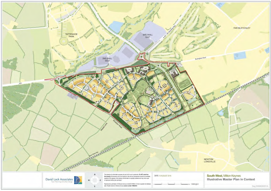
NEW02 – Land to the southwest of Milton Keynes, Newton Longville
Policy NEW02: Land to the southwest of Milton Keynes, Newton Longville
The site as shown on the Policies Map is allocated for an assumed number of 305 dwellings.
Development of this site will be supported where it:
- Creates safe and suitable access and egress.
- Considers and mitigates any cross-boundary highways and infrastructure impacts.
- Provides safe, direct and attractive active travel connections to Newton Longville and into Milton Keynes
- Provides a proportionate contribution to off-site transport improvements including.
- A new bus route to facilitate direct journeys into Milton Keynes
- A new active travel connection (3m wide Shared Use Path) connecting Newton Longville and Milton Keynes.
- Enhances and reinforces landscape buffer to the south of the site to mitigate impacts on wider views.
- The site layout should adopt a sequential approach by steering the most vulnerable aspects of the development outside of Flood Zone 2, 3a and 3b, as well as areas at risk of surface water flooding. Residential development is not permitted within Flood Zone 3b.
- Developers should utilise SuDS with multiple benefits throughout the site, particularly in areas at risk of surface water ponding.
- A detailed hydraulic model of Water Eaton Brook may be required at FRA stage to accurately represent the risk from this watercourse and set the height of any mitigation measures.
- The risk from surface water flow routes should be quantified as part of a site-specific FRA, including a drainage strategy, so runoff magnitudes from the development are not increased by development across any ephemeral surface water flow routes. A drainage strategy should help inform site layout and design to ensure runoff rates are as close as possible to pre-development greenfield rates, with areas of surface water ponding used as open space and SuDS or water compatible/essential infrastructure uses only.
- The development of the site should not prejudice the delivery of East West Rail.
6.375The site extends to approximately 7.57 hectares and is located north of Newton Longville, along the southern edge of Milton Keynes. The site is allocated for a residential allocation of 305 dwellings. The development will look towards and connect into Milton Keynes for key connections and infrastructure and so any cross-boundary impacts needed to be considered and mitigated against in consultation with Milton Keynes City Council and other key stakeholders.
6.376This allocation includes land safeguarded for East West Rail. Development will not be permitted within the limits of land subject to the safeguarding directions given by the Secretary of State for Transport in November 2025 (or any further directions or revisions to those directions) where it would conflict with or prejudice the delivery of EWR. Applicants for planning permission are strongly encouraged to enter into early dialogue with EWR Co to fully understand the nature and extent of the safeguarding and the impacts on site development and to ensure that any scheme can be designed to reflect the safeguarding and that adverse impacts on EWR are avoided, minimised or appropriately mitigated.
STO01 - Land south of Drayton Road, Newton Leys & land west of Stoke Road, Newton Leys
Policy STO01: Land south of Drayton Road, Newton Leys & land west of Stoke Road, Newton Leys
The site as shown on the Policies Map is allocated for a comprehensive residential led development.
Residential:
- The site will deliver an assumed number of 3,780 dwellings at a high-density taking account of the adjacent settlement character and identity.
Centre and Community Facilities:
- Provision of land, building and car parking for a 3FE School form of entry primary school, with a safe drop off/ pick up point outside school site will be provided on site.
- The site will provide or contribute towards, a new local centre including community facilities and parking, and the delivery or funding of healthcare provision (including temporary facilities if required). Touchdown space for Thames Valley Police should be incorporated within community hubs where a need is identified.
Development Principles:
- A comprehensive site masterplan should show the integration of the site into the settlement of Stoke Hammond to the south and take opportunities to enhance the key views. The masterplan shall also be informed by any easements needed to utility pipelines crossing the site.
- Higher density will be built closest to Milton Keynes, the centre of development and the A416. The densities are expected to reduce towards both the countryside to the south and east to ensure that the scheme responds cohesively to the wider environment, with ecological enhancements and landscaping opportunities along the site’s southernmost boundary.
- Enhance Public footpath SHA 2/1
- Provides a long-term defensible boundary to the southern edge of Newton Leys
- Provides an active travel link to the existing route running over the railway line and underneath the A4146.
- Provides a new Public Right of Way (PROW), which is an Active Travel Green Route, through the site and should be a 3m wide Shared Use Path
- Contributes to public transport service improvements and associated new facilities into Milton Keynes, including new or improved links to Bletchley railway station, and to surrounding areas.
- A more detailed traffic modelling should be undertaken to inform on the extent and design of offsite highway works. The scope and design of any detailed traffic modelling must be agreed by Buckinghamshire Council as the highway authority, in consultation with the Milton Keynes City Council highway authority.
- Shows on the masterplan the potential to provide an active travel link between the western and eastern site parcels and provides an existing route running over the railway line and underneath the A4146. It will provide new Public Right of Way (PROW) Active Travel Green Route through the site which should be a 3m wide Shared Use Path
- Upgrades PROW signage and public realm improvements.
- Development proposals must engage with the Thames Valley and Bedfordshire, Luton and Milton Keynes Integrated Care Boards to ensure appropriate primary healthcare provision.
- The development design and layout will be informed by a full detailed landscape and visual impact assessment (LVIA) that integrates the site into the landscape and the existing network of green infrastructure within Milton Keynes City and Buckinghamshire.
- Development proposals must ensure safe and suitable access for all users, including during flood events. All vehicular and pedestrian access points, as well as access routes serving dwellings and other vulnerable development, should be located outside Flood Zones 2 and 3. Where this cannot be reasonably achieved, applicants must demonstrate that safe access and egress can be provided for the lifetime of the development through alternative design measures, in accordance with national policy on flood risk. Housing use is not allowed in Flood Zone 3b.
6.377The site is approximately 94.5ha and is located to the south of Newton Leys near Bletchley. It comprises several agricultural fields, surrounding Chadwell Farm and situated between Drayton Road to the north, the A4146 Stoke Hammond Bypass and Stoke Road. Farmland adjoins the site to the south and west, with the nearby villages of Newton Longville (circa 2.5km west) and Stoke Hammond (circa 1.7km southeast) beyond.
6.378The site is currently accessed via agricultural accesses off Drayton Road and Stoke Road. A Gas Main runs across the Site on both sides of the railway line, but this constraint can be addressed through the masterplanning and is not a constraint to the delivery of the site.
6.379An inland watercourse bisects the site resulting in medium and high flood risk areas towards the south of the site. Whilst parts of Newton Leys are within Flood Zone 1 (very low risk), there is a band of land across the subject site which falls into Flood Zone 2, 3 including 3b and the site also has some surface water and groundwater risk. Any development proposed would seek to mitigate the flood risk in a sustainable manner following guidance on site design, access and egress in the SFRA Level 2 main report (2026).
6.380The northern boundary is adjacent to Drayton Road and Stoke Road, comprising low-level hedgerow and trees. The northern boundary is also bound by the ‘A’ road A4146 providing access to the A5 roundabout at South Caldecotte. The site has several trees along parcel boundaries however; there appears to be no TPO’s or Group TPO’s. The site is enclosed by hedgerow and fencing and with access deliverable via Drayton and Stoke Road. To the north the site borders existing residential development in Newton Leys known as Willow Lake, for up to 1,650 dwellings.
6.381To the north of the Site, and stopping at Bletchley Railway Station, is the currently under construction East West Rail line that runs between Oxford and Cambridge via Bicester, Milton Keynes, and Bedford. The Site also has links to the Redways cycle network at Lomond Drive on the north side of the A4146. There is a Public Right of Way (PRoW) (SHA/2/1) running north-south along the western side of the site parcel east of the A4146 connecting it both to Milton Keynes to the north (via an underpass) and Stoke Hammond to the south. This PRoW also connects along an access track (via a bridge over the railway line, and underpass beneath the A4146) to a PRoW bridleway on the allocation western parcel.
6.382The site is being promoted on behalf of landowners by a land promoter through the Call for Sites process. There are no known legal or ownership impediments to development. The site is confirmed as available.
6.383Given the location of this site, the council will engage with Milton Keynes City Council and key stakeholders covering that area on infrastructure needs. These will include health, public transport and education provision.
6.384The western part of the site has outline planning permission (24/03601/AOP) granted on appeal in February 2026. The application is for up to 290 dwellings, open space, landscaping, drainage features and associated infrastructure following demolition of existing agricultural buildings. All matters have been reserved except for access. The Section 106 agreement was signed in December 2025.
STO02 - Land east of Roman Field, Stoke Hammond
Policy STO02: Land east of Roman Field, Stoke Hammond
The site as shown on the policies map is allocated for an assumed number of 245 dwellings.
Development of this site will be supported where it:
- Provides safe and suitable access from Roman Field
- Mitigates identified cross-boundary infrastructure impacts including but not limited to highways and education.
- Mitigates the visual impact of the site from the public right of way along the Grand Union Canal
- Provides a buffer to the adjacent listed building and conservation area with the design of development responding to these heritage assets.
- It considers the archaeological potential of the site and its surroundings, including the presence of two probable Neolithic mortuary enclosures and a barrow to the east. Where evidence indicates that associated archaeological remains extend into the site, these will be treated as heritage assets of archaeological interest and should be preserved in situ.
- Enhances the connectivity of the site to the existing settlement and community facilities.
- Provides a Flood Risk Assessment which shows that the site will satisfy the Exception Test
- It is designed using a sequential approach in accordance with the different flood zones within the site. Land within flood zones 2 and 3, and 3a plus climate change (subject to a detailed flood risk assessment) should be preserved as green space. Built development should be restricted to Flood Zone 1 and where possible avoid areas of high surface water flooding. Zone 1 and where possible avoid areas of high surface water flooding.
- Provides a buffer to the existing watercourse which lies to the south of the site.
- Provides a buffer to the woodland which is to the east of the site.
- Retains where appropriate existing hedgerows and trees and where possible reinforce existing features.
6.385Land east of Roman Field is located on the eastern edge of Stoke Hammond village. The site is 7.7 hectares and is currently in agricultural use. The residential street, Roman Field is to the west and Bragenham Side Road lies to the south.
6.386Stoke Hammond’s neighbourhood plan was made in 2025. A small area of the site is allocated in the neighbourhood plan for approximately nineteen dwellings, a mix of two storey two and three bedroomed semi-detached houses or a warden-controlled housing scheme for elderly residents. The nineteen dwellings within the neighbourhood plan allocation are counted as part of the assumed delivery on site.
6.387The south of the site is within Flood Zone 2 and 3 and is also affected by surface water flooding. There is a watercourse along the southern boundary. Proposed development should be located outside the land in flood zones 2 and 3 and avoid areas at high risk of surface water flooding.
6.388The site is close to the border of Buckinghamshire with Milton Keynes. Consideration should be given to the cross-boundary infrastructure needs, including but not limited to highways, education and health. The primary healthcare infrastructure provision will need engagement with the Thames Valley Integrated Care Board and the Bedford, Luton and Milton Keynes Integrated Care Board.
WHA01 - Shenley Park, Whaddon
Policy WHA01: Shenley Park, Whaddon
Development proposals for Shenley Park, as identified on the Policies Map, will deliver a comprehensive, landscape-led mixed-use development of approximately 99 hectares. The site will deliver an exemplar, high-quality and sustainable new neighbourhood of regional significance.
The development shall provide:
- At least 1,265 dwellings
- A 110-bed care home / extra care facility
- A 2FE primary school, and where required, land for a secondary school or contributions to off-site provision.
- A mixed-use local centre, including community and either on site healthcare facilities, or a contribution to offsite facilities where identified.
- A multi-functional green and blue infrastructure network
- A link road between the A421 and H6 and/or H7
- Public transport improvements and high-quality walking and cycling connections.
Development must be delivered in accordance with a comprehensive masterplan and the Shenley Park Development Brief.
Place-making and Design.
Development must deliver a high-quality, landscape-led and locally distinctive place. Proposals shall:
- Respond to landscape and context.
- Be informed by landscape character, topography, views and historic context
- Respect the rural setting and character of Whaddon village and Conservation Area
- Provide defensible long-term boundaries whilst enabling connectivity
- Protect, enhance and connect biodiversity across the site.
- Create a strong sense of place.
- Deliver a distinctive, welcoming and inclusive new neighbourhood
- Provide a walkable neighbourhood structure, with a local centre within a 10 to 15-minute walk
- Deliver a central public square as a focal point for activity and community use
- Provide a rural Whaddon buffer, including informal recreation opportunities
- Integrate heritage and archaeological assets into the design and layout.
- Ensure high-quality built form and public realm.
- Deliver high-quality buildings, streets and spaces that promote health, safety and wellbeing
- Provide a varied sequence of spaces, views and landmarks
- Clearly define public and private realms through layout and landscape design
- Integrate SuDS as part of the landscape structure
- Provide appropriate and well-designed waste and recycling storage
- Prioritise pedestrian and cycle movement, including crossings where appropriate.
Movement and Connectivity
Development must prioritise sustainable and integrated transport. Proposals shall:
- Walking and cycling
- Provide high-quality routes linking to Whaddon, Bletchley and Milton Keynes
- Extend Tattenhoe Valley Park into the site
- Retain, enhance and connect public rights of way, including bridleways.
- Highways and access
- Provide safe vehicular access from the A421 Buckingham Road
- Deliver a link road through the site connecting to H6 Childs Way and/or H7 Hayton Way
- Undertake detailed transport modelling to inform highway interventions, including A421 improvements.
- Public transport
- Safeguard and accommodate a public transport priority route, including future Mass Rapid Transit (MRT) where possible
- Provide improved bus services and facilities, including links to Bletchley railway station
- Support potential Park and Ride / MRT infrastructure where possible.
- Network integration
- Integrate development with the Redway and Sustrans networks.
Community Infrastructure
Development must provide social infrastructure in a timely and coordinated manner. Proposals shall:
- Deliver land, buildings and parking for a 2FE primary school.
- Provide either:
- Contributions to off-site secondary education, or
- Land for a new secondary school, where required.
- Deliver a local centre, including:
- Community facilities
- Local services
- Healthcare provision (on-site or via contribution, including temporary provision if required).
Green and Blue Infrastructure
Development must be landscape-led and deliver a coherent green infrastructure network. Proposals shall:
- Landscape and ecology.
- Provide a substantial countryside buffer to Whaddon, including enhancement of Briary Plantation
- Retain and enhance:
- Ancient woodland (including Thrift Wood)
- Hedgerows and woodland blocks
- Deliver a long-term ecological management plan.
- Flood risk and drainage.
- Deliver green corridors aligned to surface water flowpaths
- Reduce downstream flood risk in the Loughton Brook catchment
- Ensure key infrastructure, including A421 access, remains operational during flood events.
Delivery and Phasing
Development must be comprehensively planned and delivered. Proposals shall:
- Be supported by a comprehensive masterplan and phasing strategy.
- Demonstrate coordinated delivery of infrastructure and services.
- Be supported by planning obligations and agreements as necessary.
- Ensure ongoing collaboration between relevant authorities and infrastructure providers.
6.389The site covers an area of around 99 ha and is in agricultural use with areas of woodland plantations. Surrounding land uses are similarly predominantly agricultural although the eastern boundary is defined by the Milton Keynes Boundary Walk, the existing residential development and land currently being developed as part of Milton Keynes.
6.390Other than the 11KV overhead powerlines crossing the site there are no other utilities present that would significantly constrain the proposed development and sufficient new utility infrastructure can be provided.
6.391There is one footpath running across the southern part of the site. Long distance bridleways run along the northern and eastern boundaries. The topography of the southern half of the site rises from the A421 to the Shenley Road.
6.392The remainder of the site from Shenley Road is flat to the northern boundary.
6.393The development brief sets out a framework plan for the site.
WHA02 – Land West of Shenley Park, Whaddon
Policy WHA02: Land west of Shenley Park, Whaddon
The site as shown on the Policies Map is allocated an assumed 1,240 dwellings.
New development will be supported where:
- Provision of up to 1,240 homes that continues the expansion from Shenley Park (WHA001) to the east. Proposals must demonstrate, through a Design and Access Statement and supporting landscape analysis and how the scheme responds positively to the scale, grain, and identity of neighbouring settlements.
- Development proposals within or affecting the setting of Whaddon Conservation Area must preserve or enhance its significance, including its character, appearance, and historic context.
- Provision of land, buildings and car parking for a 2FE + 1FE primary school (capacity 210) with 30 place nurseries with a safe drop off / pick up point. Infrastructure will need to be provided and phased alongside development, the details of which will be agreed through developer contribution agreements.
- The site will be designed using a landscape-led and green infrastructure approach. The development design and layout will be informed by a full detailed landscape and visual impact assessment (LVIA) that integrates the site into the landscape and the existing network of green infrastructure.
- Create high quality walking and cycling links to Whaddon and Shenley Park and onwards to Milton Keynes.
- Existing vegetation should be retained where practicable, including existing woodlands and hedgerows and consider the urbanising effects on the nearby ancient woodland, Priority Habitats and Local Wildlife Site. Specifically, Thickbare Wood and Coddimoorhill Wood, which are both ancient woodlands. These areas will require extensive buffers of 50m.
- The scheme layout shall have regard to the findings of an archaeological investigation including the excavation of the Roman Settlement.
- The development must provide a satisfactory vehicular access to Shenley Park
- Development must provide north south linkages for active travel and overcome topographical changes.
- More detailed traffic modelling will be required to inform on the extent and design of off-site highway works, which is likely to include capacity improvements to the A421. The scope and design of any detailed traffic modelling must be agreed by Buckinghamshire Council as the highway authority.
- Existing public rights of way need to be retained, enhanced and integrated into the development with safe and secure environments as part of a wider network of sustainable routes, to directly and appropriately link the site with surrounding communities and facilities.
- Provision of public transport service improvements and associated new facilities into Milton Keynes.
- An air quality and noise assessment shall be submitted to and approved in writing by the Council prior to development commencing.
- Development should be steered outside of the areas of surface water and fluvial flood risk.
- Developers should consider utilising the unnamed ordinary watercourses as green corridors or as location for SuDS.
- A detailed hydraulic model of the ordinary watercourse flowing through the site may be required at FRA stage to accurately represent the risk from this watercourse and set the height of any mitigation measures.
- Blockage modelling should be conducted to assess the residual risk associated with potential blockage of the bridge structures over the ordinary watercourse along the public footpaths to the southeast.
- The risk from surface water flow routes should be quantified as part of a site-specific FRA, including a drainage strategy, so runoff magnitudes from the development are not increased by development across any ephemeral surface water flow routes. A drainage strategy should help inform site layout and design to ensure runoff rates are as close as possible to pre-development greenfield rates, with areas of surface water ponding used as open space and SuDS or water compatible/essential infrastructure uses only.
- Arrangements for safe access and escape will need to be provided for the 1% AEP fluvial and surface water events with an appropriate allowance for climate change, considering depth, velocity, and hazard. Design and access arrangements will need to incorporate measures, so development and occupants are safe.
- Provisions for safe access and escape should not impact on surface water flow routes or contribute to loss of floodplain storage. Consideration should be given to the siting of access points with respect to areas of surface water flood risk.
- The site is located within a catchment identified as highly sensitive to the cumulative impacts of development on flood risk. The site-specific FRA and surface water drainage strategy should consider the recommendations outlined for catchments of high sensitivity in the Buckinghamshire Level 1 SFRA Cumulative Impacts Assessment.
- The unnamed ordinary watercourse, which flows through the site requires a width of buffer, to be agreed in consultation with Buckinghamshire Council, should be maintained between the riverbank and any built structures, to enable riparian owners to access and maintain the channel.
- Development proposals for the site to comply with other recommendations for site design and making development safe set out in the SFRA Level 2 report (2026)
6.394The site covers an area of around thirty-one hectares and is grassland with two areas of woodland and several existing hedgerows. Surrounding land uses are rural with grassland and woodland to the northwest and south, the land to the east is an existing allocation for residential use with Milton Keynes beyond. Whaddon villages lies some 700m to the northwest.
6.395The site falls to a shallow valley running east-west through the centre of the site there are two substantial areas of woodland on the site which should be retained. New vehicular connections should be provided the link road at Shenley. New active travel access should be provided to Whaddon.
Tier 2:
- Buckingham
- Chesham
- Princes Risborough
- Wendover
BUC01 - Former Inov8 site, Tingewick Road, Buckingham
Policy BUC01: Former Inov8 site, Tingewick Road, Buckingham
The site as shown on the Policies Map is allocated for up to 2.7 hectares of academic uses (use class F1 (a)), including an assumed 300 units of student accommodation for the University of Buckingham. If evidence is provided that the University of Buckingham’s academic and student accommodation needs have been met elsewhere, the site as shown on the Policies Map is allocated for an assumed 125 dwellings.
New development will be supported where:
- Built development consisting of any sort of living accommodation, including purpose-built student accommodation, should not be proposed in any areas shown as Flood Zone 3 on the Environment Agency's Flood Map for Planning.
- An acceptable ecological buffer is maintained between all built development and engineering operations and the River Great Ouse.
- The proposed development has been clearly informed by and responds positively to an appropriately detailed character analysis of Buckingham’s important historic buildings, materiality, scale and architecture with regards to building.
- The proposed development has been clearly informed by and responds positively to an appropriately detailed survey of the existing protected trees with regards to the siting of built form, engineering operations and infrastructure within the site.
6.396The site covers an area of around 2.7 hectares and has been a vacant brownfield site for over a decade which previously was used for employment with industrial buildings on the site. Around the periphery of the site and particularly along the bank of the river are several trees many of which are subject to preservation orders. The site when previously in use had four vehicular access points. The site is bounded along its eastern and southern boundaries by the conservation area. Most of the site is within Flood Zone 2 with a lesser area along the eastern edge within Flood Zone 3.
6.397The site is owned by the University of Buckingham and has been identified in the Buckingham Neighbourhood Plan as a Brownfield Opportunity Site, under policy HP2, and is considered suitable for development. The neighbourhood plan is very supportive of any expansion or redevelopment plans which support the universities presence in the town and a scheme for this site which includes the provision of open market homes should it be demonstrated that the universities accommodation needs has been met elsewhere.
6.398The site previously was granted planning permission in 2015 (13/03041/AOP) for three hundred units of student accommodation and 7,100 sq.m of educational facilities. The PPG[1]sets out that student accommodation, whether it consists of communal halls of residence or self-contained dwellings, and whether it is on campus, can in principle count towards contributing to an authority’s housing land supply by applying a ratio. A ratio of 2.4 [2]has been used which means three hundred student units equalises to 125 homes that can be counted in the supply. If this need were met elsewhere the area of the site not in Flood Zone 3, around 1.95ha, could also reasonably deliver around 125 homes.
CHS01 - Star Yard, St Mary’s Way, Old Town, Chesham
Policy CHS01: Star Yard, St Mary’s Way, Old Town, Chesham
The site as shown on the Policies Map is allocated for an assumed 240 dwellings.
New development will be supported where:
- It delivers a density of development that makes efficient use of this previously developed site while responding positively to the scale, height, massing, character and appearance of the surrounding townscape and preserving the character and identity of Chesham town centre.
- It is planned in a manner that responds positively to the best characteristics of the surrounding area using a landscape-led approach, taking account of the character and setting of the local landscape. Development should retain and integrate existing trees and landscape features wherever practicable and provide appropriate new landscaping as part of a landscape-led design approach.
- Safe and suitable access shall be provided for all users whilst maintaining access to existing public car parking and rear servicing arrangements for premises fronting the High Street.
- Development should ensure that sufficient publicly accessible parking is maintained either on-site or at an alternative suitably located town centre site, unless robust evidence demonstrates that a reduced level of provision would not adversely affect the vitality and viability of Chesham Town Centre.
- Existing public pedestrian routes between Star Yard, the High Street and adjoining town centre destinations shall be retained and, where possible, enhanced.
- Appropriate financial contributions towards education infrastructure, including upper, grammar and special school provision, will be required where justified by evidence and in accordance with relevant infrastructure policies.
- A contribution towards improvements to open space at Lowndes Park.
- SANG and SAMM mitigation is in place, in line with policies NE12, NE13, NE14 and the latest Mitigation Strategy. Permission will not be granted until mitigation is in place.
6.399This site of 0.59 hectares is in the Star Yard surface car park, one of the main car parks serving Chesham town centre. The site is to the rear of the High Street with its current access off Blucher Street and with the A416 St Marys Way running across the rear of the site.
6.400The site is complex having a culvert of the river Chess running underneath it and with many premises fronting the high street, having a right of access across the car park. The site also falls within Flood Zone 2, and any development would need to demonstrate mitigation against flooding in line with the policies within this plan and the Strategic Flood Risk Assessment. The site also provides access to the Catlings car park and the Chesham Town council offices.
6.401The site is located to the rear of the high street conservation area although there are proposals to extend the conservation area to include Lowndes Park the other side of St Mary's way. Development proposals must conserve the significance of nearby heritage assets, including the Chesham Conservation Area and its setting, informed by an appropriate heritage assessment.
6.402Given the site's role as a principal public car park serving Chesham Town Centre, proposals will need to demonstrate that adequate public parking provision remains available to support the vitality and viability of the town centre.
6.403The site lies within the Zone of Influence of Chilterns Beechwoods SAC. Permission will not be granted until SANG and SAMM mitigation is in place, in line with policies NE12, NE13, NE14 and the latest Mitigation Strategy. It is anticipated that the site could secure credits at Bell Lane SANG.
CHS02 - Albany Place Car Park, Chesham
Policy CHS02: Albany Place Car Park, Chesham
The site as shown on the Policies Map is allocated for an assumed number of 30 dwellings.
New development will be supported where:
a) Replacement car parking in an alternative town centre location with no loss in the number of public car parking spaces is provided unless it can be proved the number of spaces currently provided is no longer required.
b) The existing on-site theatre is re-provided in a suitable town centre location.
c) It addresses the significant flood risk constraints on the site, avoiding high fluvial and surface water risk where possible and provide a Flood Risk Assessment. Off-site flood storage would be required to manage fluvial and surface water flood risk at the site. Housing is not allowed in areas of Flood Zone 3b.
d) Detailed baseline and post-development 1D-2D fluvial modelling, informed by CCTV survey of extended culverted reaches, will be required as part of a site-specific Flood Risk Assessment. This includes blockage modelling of the culverted River Chess in the east and south of the site.
e) SANG and SAMM mitigation is in place in line with policies NE12, NE13, NE14 and the latest Mitigation Strategy. Permission will not be granted until mitigation is in place.
6.404The site of 0.35ha lies in the centre of Chesham on the A416 St Mary’s Way. It includes the 330-seat capacity Elgiva Theatre as well as adjacent car parking for seventy-one cars (including 3 disabled spaces). The current theatre building was opened in 1998, replacing the original theatre which was demolished to make way for the St Mary’s Way supermarket complex on the opposite side of the road.
6.405The adjacent car park is not only used for the theatre, but it also serves the town centre. Vehicular access to the site is via a short link road from the adjacent Elgiva Roundabout. The site is surrounded by a mix of commercial, public and residential buildings. The Chesham Conservation Area is opposite the site, separated by St Mary’s Way.
6.406Redevelopment of the site could present significant risk in terms of flooding. Developers will need to follow the SFRA Level 2 recommendations in terms of site-specific guidance for site design and making development safe.
6.407The site lies within the Zone of Influence of Chilterns Beechwoods SAC. Permission will not be granted until SANG and SAMM mitigation is in place. It is anticipated that the site could secure credits at Bell Lane SANG.
CHS03 - Water Meadow Car Park, Chesham
Policy CHS03: Water Meadow Car Park, Chesham
The site as shown on the Policies Map is allocated for an assumed number of 55 dwellings. New development will be supported where it:
- Provides land for dwellings at a density that takes account of the existing curtilage, the scale and massing of the buildings adjacent to the site, and that of the settlement character and identity if appropriate.
- Creates safe access to the new development without blocking access to public parking or rear servicing of existing premises fronting Water meadow.
- Maintains public car parking provision on site or provided in an alternative central location with no loss in the number of public car parking spaces unless it can be proved the number of spaces currently provided is no longer required.
- Maintains existing public walking routes from Water meadow car park to Wey Lane as well as access from the public parking to the zebra crossing across St Mary's Way.
- Provides a contribution towards improvements to open space at Lowndes Park.
- Provides contribution towards additional or improved children’s play areas and informal play space within Lowndes Park.
- Contributes to SANG and SAMM mitigation in accordance with policies NE12, NE13, NE14 and the latest Mitigation Strategy.
- Contributes to SANG and SAMM mitigation in accordance with policies NE12, NE13, NE14 and the latest Mitigation Strategy. Permission will not be granted until SANG and SAMM mitigation is in place.
- Addresses the significant flood risk constraints on the site, particular surface water risk and avoid development in the highest flood risk areas. If development is proposed within the area at risk of flooding, minimal obstruction measures, such as under croft parking, are likely to be required to raise finished floor levels above the design flood level. Ground raising should be avoided due to the fluvial and surface water risk.
6.408This site of 0.38 hectares is in the water meadow surface car park one of the main car parks serving Chesham town centre. The site is located to the Southeast of Market Square which itself is to the south of the main High Street. The car park is set back from the road behind another frontage development and as such it is not visible from the main retail area. Its current access is off a roundabout at the Junction of St Mary’s Way with Red Lion Street
6.409The site is located within the Chesham conservation area. There are proposals to extend the conservation area to include Lowndes Park and to add houses in Wey Lane which back onto the site. Any re-development of the car park would need to demonstrate a way to mitigate the impact of the setting of the conservation area and the conservation area itself.
6.410The site is one of the main long stay car parks in Chesham which serves the retail centre. It is therefore used mostly by people who need to park all day to work in the town. As such it is vital that any parking spaces lost are re-provided to maintain sufficient, easily accessible, public car parking to maintain the retail success of the town’s high street.
6.411The site lies within the Zone of Influence of Chilterns Beechwoods SAC. Permission will not be granted until SANG and SAMM mitigation is in place, in line with policies NE12, NE13, NE14 and the latest Mitigation Strategy. It is anticipated that the site could secure credits at Bell Lane SANG.
6.412Redevelopment of the site could present significant risk in terms of flooding. Developers will need to follow the SFRA Level 2 recommendations in terms of site-specific guidance for site design and making development safe.
PRI01 - Land at Princes Risborough Station
Policy PRI01: Land at Princes Risborough Station
1. The site as shown on the Policies Map is allocated for a mixed-use development comprising an assumed number of 80 dwellings, together with small-scale convenience retail, public realm, bus infrastructure, and Princes Risborough expansion Relief Road infrastructure.
2. Development proposals will be supported where it:
- Delivers a high-quality, residential-led scheme that makes effective use of this brownfield site, including appropriate density for a station-adjacent location.
- Provides an appropriate level of car parking that reflects the site’s sustainable location, including opportunities to reduce car dependency.
- Includes small-scale convenience retail and food and drink uses (within Use Class E) that are proportionate in scale and directly related to serving the station and local community.
- Supports appropriate tourism-related uses, such as a hotel or visitor information facility (including café uses), where these complement the role of the station and town.
- Provides a new public square and associated public realm which:
- facilitates bus access and interchange.
- delivers safe, convenient and legible pedestrian and cycle connections to the railway station.
- Safeguards and delivers a route through the site to accommodate the Princes Risborough alternative route, including an appropriate junction with Station Road / Station Approach.
- Provides appropriate access to the main station car park.
- Makes proportionate contributions to off-site infrastructure, having regard to the scale and nature of development and any on-site provision.
- Incorporates flood risk management and site design and safety measures recommended in the SFRA Level 2 site summary sheet, including the de-culverting of the existing watercourse, where feasible and appropriate
- The site layout should adopt a sequential approach by steering the most vulnerable aspects of the development outside of Flood Zone 2 and 3, as well as areas at risk of surface water flooding.
- If development is taking place in areas at significant fluvial or surface water flood risk, habitable spaces and sleeping accommodation should not be located on the ground floor. These areas could be designated for less vulnerable purposes such as car parking.
- A 1D-2D detailed hydraulic model of the culverted Horsenden Stream, based on topographic survey of the watercourse channel, may be required at FRA stage to accurately represent the risk from this ordinary watercourse and set the height of any mitigation measures.
- Blockage modelling should be conducted to assess the residual flood risk associated with potential blockage of the culverted Horsenden Stream below the site.
- Contributes to the enhancement of the Culverton Mill corridor, including biodiversity, landscape and amenity value.
6.413There are no listed buildings on the site, and the site is not in a conservation area. There is a Listed Building approximately 145m from the site to the Northwest. The design of the surrounding area is a medium density, with surrounding residential development consisting mostly of detached and semi-detached dwellings of two storeys. There is a block of flats to the north which is three storeys’ high.
6.414The redevelopment of the land at Princes Risborough Station will provide an important gateway to the town and to the Chilterns National Landscape. Development proposals are required to be of a high standard of design and a range of mixed uses appropriate for the site location.
6.415The station will become the focus of a wider mixed-use area with redevelopment of sites east of the station for residential, employment and commercial activities, with potential for a hotel. Retail provision should be small-scale convenience retail: the intention is to meet day-to-day needs associated with the station and local community, rather than functioning as a wider destination.
6.416The site is required to provide part of the Princes Risborough Relief Road. The link between Summerleys Road and Picts Lane will relieve traffic on Poppy Road and create more legible connections between the station and the wider road network. Passing traffic avoids the junction of Station Road with Picts Lane. It is envisaged that traffic lights at the junction of the new road with Summerleys Road, Station Road and Station Approach will manage traffic around the station, with a phase for safe crossing of pedestrians and cyclists. This is subject to further detailed modelling at application stage in line with Policy TR1.
6.417The link between Summerleys Road and Picts Lane will relieve traffic on Poppy Road and create more legible connections between the station and the wider road network. Passing traffic avoids the junction of Station Road with Picts Lane. It is envisaged that traffic lights at the junction of the new road with Summerleys Road, Station Road and Station Approach will manage traffic around the station, with a phase for safe crossing of pedestrians and cyclists. This is subject to further detailed modelling at application stage in line with Policy TR1.
6.418The creation of a public station square will be the focus of connections with the rest of the town: Station Road / Bell Street provide the traffic route; Stratton Road / Manor Park Avenue provide a route for pedestrians and cyclists. It should be of the highest quality and green in character, to set the scene when arriving, and support the integration of the Chinnor steam railway with Princes Risborough station, to improve the visitor experience and promote tourism. The addition of a hotel would fulfil a long-held aspiration of the local community.
6.419The station square will gather up the approaches to the station and provide facilities for cars and car parking and for public transport to the station, and for walking and cycling routes to and through the station. There is the potential for a footbridge to the Princes Estate, making train and public transport access much better and relieving the estate’s relative isolation. Station Square will provide:
- Improved and enlarged forecourt with integrated bus facilities for interchange and onward travel.
- Integrated car parking and cycle hire
- A small-scale convenience retail space - retail provision is ancillary to the station function and not intended to compete with Princes Risborough town centre.
- A combined café / information centre
- Interpretive information and signage for the railway system in general and the steam railway in particular, and of local cycling and walking routes
6.420East of the railway line, redevelopment of sites needs to reflect the increased importance of the station and its connections to the town centre with dense development surrounding high quality public spaces.
6.421Parts of the site are within Flood Zones 2 and 3a, and there is also a risk of surface and ground water flooding. Development of the site must recognise and implement the recommendations of the Level 2 Strategic Flood Risk Assessment.
6.422De-culverting the stream should be incorporated into these measures and presents an opportunity to enhance the stream corridor and improve biodiversity, preferably without the need for the new road to cross the stream requiring a culvert. However, some limited culverting may be required to achieve an appropriate road alignment.
6.423The Council will require an application for this site to demonstrate how the application is making a fair and equitable contribution towards the provision of off-site infrastructure, considering the on-site infrastructure provided.
WEN01 – Land at RAF Halton
WEN01: Land At RAF Halton
Land Use Requirements:
The site as shown on the Policies Map is allocated for a comprehensively planned residential led development.
Residential:
- The site will deliver an assumed number of 1,000 dwellings and infrastructure at a density that takes account of the existing curtilage, the scale and massing of the buildings on the site, and that of the adjacent settlement character and identity if appropriate, as well as retaining the openness of the green belt.
- Higher density residential neighbourhood close to the local centre and fronting Upper Icknield Way and Chestnut Avenue
- Moderate and lower density residential development of Maitland barracks and upper parade ground, including conversion of locally listed buildings.
Centre and Community Uses:
- Land, buildings and car parking for a new local centre which includes a community hall and a medical facility will be provided on site. Including the re-use of St Georges Church. Where there is a need identified, facilities for Thames Valley Police should be provided within the local centre.
- On site land, buildings and car parking for a 2FE combined primary school will be delivered which will also include playing field provision with a safe drop off and pick up point.
- Former stables and cinema buildings could both be converted to either community or leisure use within a parkland setting should they not be suitable for conversion to residential.
Green Infrastructure and Open Space:
- Fifty percent green infrastructure will be provided on site which reflects the high level of open space already present on the site including green corridors and will link to other new development areas and wider countryside.
- Natural parkland and grassland habitat with enhanced walking/cycling access to Wendover Woods and into the Chilterns National Landscape
- Retention of the old station building within a public square, and creation of an extended east west tree-lined avenue.
- Parade ground becomes a new public park with play space and potential community use of the former Trenchard Museum along with potential for vehicle parking space.
- North-south green corridor of parkland and play space with views over Aylesbury Vale
- The site will retain existing sports facilities, including the Nuffield Pavillion, as part of a long-term strategy for sport and recreation to serve new residents and the existing community.
- Suitable Alternative Natural Greenspace (SANG) and Strategic Access Management and Monitoring (SAMMS) contributions in accordance with policies NE12 and NE13, and the latest Chilterns Beechwoods SAC Mitigation Strategy.
Transport Infrastructure:
- The site will deliver a new internal spine road connecting to Halton Lane and Upper Icknield Way enabling internal access to existing road networks.
- Junction improvements onto the B4009 Upper Icknield Way will be delivered.
- B4009 roundabout upgrades will be delivered.
- The site will deliver a new Halton Lane/ RAF Halton Spine Road Junction.
- Traffic calming and new pedestrian/cycle crossing points on Upper Icknield Way and Chestnut Avenue to create pedestrian-friendly streets. Traffic calming measures should also facilitate safe walking and cycling infrastructure in line with LTN 1/20
Development Principles:
Development will be permitted where proposals:
- Are planned in a manner that responds positively to the best characteristics of the surrounding area using a landscape-led approach, taking account of the character and setting of the Chilterns National Landscape
- Provide for public transport into Wendover and to surrounding areas.
- Establish and safeguard for a network of cycling and walking links to and from Aylesbury Town and to the wider area.
- Deliver Upper Icknield new signalisation and reprofiling of junction.
- Provide a financial contribution to delivery of alteration to existing bus route: Aylesbury - Stoke Mandeville - RAF Halton.
- Upgrade and provide new active travel links (all 3m wide SUP).
- Provide financial contributions to Buckinghamshire Greenway (north-south county walking and cycling corridor). The greenway should be compliant with LTN 1/20 at a minimum to make as attractive to users as possible.
- Provide a financial contribution towards the provision of upper/grammar/special school places.
- Upgrade internal active travel network including to the existing PROW to form part of the internal footpath network within the site. The network is to connect into LCWIP 49 for a strategic link. New active travel network within the site should be designed to connect into internal and external PROWs to ensure local attractions are able to be done so via active travel.
Historic Heritage
- Restoration and enhancement of the Registered Park and Garden open parkland associated with Halton House, including the key features that define the historic parkland.
- Listed Groves and Henderson barracks converted to residential or other appropriate use.
- Incorporate relocated Trenchard Museum collections and interpretation of the nearby WWI trenches near to the existing Museum Resource Centre.
- Enhancement of the setting of the Scheduled Monument.
6.424The site is eighty-two hectares and lies on the eastern edge of the built-up area of Wendover. The site is located off B4009 Upper Icknield Way and is currently in military use. RAF Halton is a long-established military training base although the site is programmed for closure. The current closure date is 2030 although this may change subject to military decision making on replacement facilities. The site form’s part (the most built-up part) of the wider RAF Halton site which includes other ancillary land and the associated grass airfield complex.
6.425The site is close to the border of Buckinghamshire in terms of primary care provision, and the primary healthcare infrastructure provision will need engagement with the TV ICB and the Central and East ICB.
6.426This site was an allocation in the current/former Vale of Aylesbury Local plan. However, because of the delay in the closure of the RAF base the allocation has been carried forward into this local plan. The former site allocation required a masterplan be drawn up for the site. This masterplan was drafted between Buckinghamshire Council and the site promoters the Defence Infrastructure. The development was subject to a full public consultation process and was formally adopted by Buckinghamshire council.
6.427The site lies within the zone of influence of the Chilterns Beechwoods Special Area of Conservation (SAC). Development is likely to generate recreational pressure and will require appropriate mitigation. Planning permission will not be granted until suitable SANG and SAMM mitigation is secured, in accordance with Policies NE12, NE13 and NE14 and the latest mitigation strategy.
6.428The RAF Halton development brief includes a concept masterplan the key points of this are set out below. (numbers in list relate to locations on the following site map)
- Mixed use local centre on Chestnut Avenue including the reuse of St George’s Church
- New two form entry primary school with playing fields to the northeast adjacent to the Registered Park and Garden
- Restoration and enhancement of the Registered Park and Garden open parkland ten. Listed Groves and Henderson barracks converted to residential or other appropriate use associated with Halton House, including the key features that define the historic parkland.
- Sports and leisure corridor incorporating the Nuffield Pavilion (which is retained for community/sports use), allotments, play space and open space comprising of existing parkland and woodland
- Retention of the old station building within a public square, and creation of an extended east west tree-lined avenue.
- Higher density residential neighbourhood close to the local centre and fronting Upper Icknield Way and Chestnut Avenue
- There is an aspiration to incorporate relocated Trenchard Museum collections and interpretation of the nearby WWI trenches near to the existing Museum Resource Centre.
- Traffic calming and new pedestrian/cycle crossing points on Upper Icknield Way and Chestnut Avenue to create pedestrian-friendly streets. Traffic calming measures should also facilitate safe walking and cycling infrastructure in line with LTN 1/20
- Improvements to the junction of Upper Icknield Way and Chestnut Avenue to enable easy pedestrian and cycle connectivity
- Parade ground becomes a new public park with play space and potential community use of the former Trenchard Museum along with potential for vehicle parking space.
- Natural parkland and grassland habitat with enhanced walking/cycling access to Wendover Woods and into the Chilterns National Landscape.
- North-south green corridor of parkland and play space with views over Aylesbury Vale
- Moderate and lower density residential development of Maitland barracks and upper parade ground, including conversion of locally listed buildings
- Former stables and cinema buildings could both be converted to either community or leisure use within a parkland setting should they not be suitable for conversion to residential. They could be converted to non-residential uses such as a green mobility hub, cycle hire hub, co working hub café.
- Enhancement of the setting of the Scheduled Monument.
- Connections and routes to: Halton Village; Wendover centre and railway station.
Aylesbury; and the Buckinghamshire Greenway.
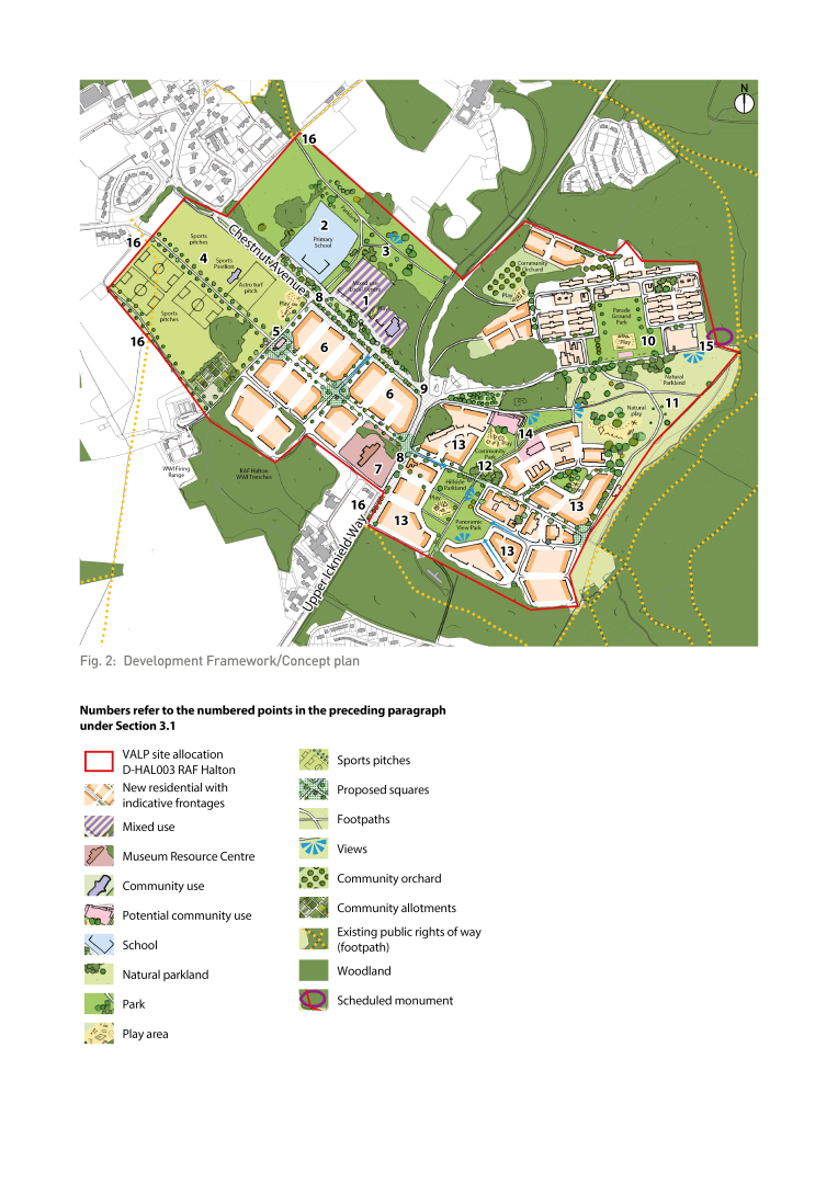
Tier 3:
- Aston Clinton
- Haddenham
- Stoke Mandeville
- Winslow
- Wooburn and Bourne End
AST01 - Aston Clinton North
Policy AST01: Aston Clinton North
Land Use Requirements:
The site as shown on the Policies Map is allocated for a comprehensively planned, mixed use development.
Residential:
- The site will deliver an assumed number of 1,660 dwellings at a higher-density form that ensures a sensitive transition from the established character of the adjoining settlement.
Employment:
- 33,000 sqm of employment will be deliver on 1-2ha of land. This will be for general industrial and warehousing uses.
Centre and Community Uses:
- Land, building and car parking will be provided on site for a 2FE primary school with a safe drop off/ pick up point.
- Land, building and car parking provision will be provided on site for a new local centre which will include a community hall and a contribution towards or delivery of a healthcare facility either by way of site provision or direct funding. This will provide approximately 1,000 sqm of town centre retail uses.
Transport:
- Satisfactory vehicular access will be provided to the slip road onto the A41, Aylesbury Road, Waring Crescent, Chapel Drive and New Road, and provision of improvements to College Road South.
- Provision of and /or financial contributions will seek to improve College Road South
Development Principles:
- Create a sustainable community providing a mix of uses to ensure that housing development is accompanied by infrastructure services and facilities.
- Proposals must demonstrate, through a Design and Access Statement and supporting townscape analysis, how the scheme responds positively to the scale, grain, and identity of the neighbouring town.
- Infrastructure will need to be provided and phased alongside development, the details of which will be agreed through developer contribution agreements.
- The site will be designed using a landscape-led and green infrastructure approach. The development should provide a stronger edge to the settlement. Have more sensitive development in the Western and Eastern fields and provide a landscape buffer to the A41.The development design and layout will be informed by a full detailed landscape and visual impact assessment (LVIA) that integrates the site into the landscape and the existing network of green infrastructure within Aston Clinton and Buckinghamshire.
- The site layout shall adopt a sequential approach by steering the most vulnerable aspects of the development outside of Flood Zone 2, 3a and 3b, as well as areas at risk of surface water flooding. Residential development is not allowed in Flood Zone 3b.
- A detailed hydraulic model of the all the watercourses, including Main Rivers and ordinary watercourse within the site will be required at FRA stage to accurately represent the risk from these watercourses, understand how they interact and set the height of any mitigation measures.
- Blockage modelling should be conducted to assess the residual risk associated with potential blockage of the culverts under the A41.
- Developers should utilise SuDS with multiple benefits throughout the site, particularly in areas at risk of surface water ponding.
- Conserve the setting of the Scheduled Monument to the east of the site by creating a well-designed and managed buffer.
- Before submitting any proposal, a site specific detailed combined hydraulic model of the Wendover Brook should be provided and approved as part of a site-specific flood risk assessment, to demonstrate that the site can be made safe for its lifetime.
- Provide public transport service improvements and associated new facilities into Aston Clinton and Aylesbury.
- Aston Clinton North existing PROW should be improved. This includes paving and integrating into Active Travel network planned throughout the site and creating high quality walking and cycling links to and from Aston Clinton and College Business Park North. 3m wide SUP
- Financial contributions to active travel links rerouting LCWIP10 Aylesbury Aston Clinton Tring will be provided.
- The site lies within the Zone of Influence of Chilterns Beechwoods SAC. Permission will not be granted until SANG and SAMM mitigation is in place, in line with policies NE12, NE13, NE14 and the latest Mitigation Strategy.
6.429The site covers an area of around 52 hectares and is in agricultural use with several existing hedgerows. Surrounding land uses are the existing settlement of Aston Clinton to the south; the A41 and College Road Business Park to the north; as well as open agricultural fields.
6.430The site is flat with the narrow College Road South running through it. New connections should be provided into Aston Clinton and onto the A41 and surface water flooding on the western part of the site should be managed. The site should provide a new primary school and a small local centre.
6.431The site is close to the border of Central Bedfordshire in terms of primary care provision, and the primary healthcare infrastructure provision will need engagement with the TV ICB and the Central and East ICB.
6.432The site lies within the Zone of Influence of Chilterns Beechwoods SAC. Permission will not be granted until SANG and SAMM mitigation is in place, in line with policies NE12, NE13, NE14 and the latest Mitigation Strategy. It is envisaged that credits can be secured at Kingsbrook Meadow SANG.
HAD01- Aston Road, Haddenham
Policy HAD01: Aston Road, Haddenham
The site as shown on the Policies Map is allocated for an assumed number of 560 dwellings.
- Accords with a comprehensive masterplan, to be submitted to and formally approved by the Council prior to the determination of any planning application, to ensure coordinated and integrated development across the whole site.
- The layout and design of development is to consider the existing underground fuel pipeline, ensuring safety and compliance with relevant standards.
- Delivers appropriate traffic calming measures along Aston Road.
- Does not prejudice the delivery of the Haddenham NESS site.
- The site is located close to the Haddenham Wastewater Treatment Works (WwTW).
Development will be permitted only where it can be demonstrated that:
- The living conditions of future occupiers will not be adversely affected by odour or other emissions arising from the WwTW, informed by a proportionate Odour Impact Assessment.
- The design, layout and scale of development will not prejudice the continued and effective operation of the WwTW, nor place unreasonable constraints on its future maintenance, operation or permitted activities.
- Early engagement with the operator of the WwTW has been undertaken to inform site design, and mitigation measures.
- Any necessary mitigation is incorporated through site layout, buffers, landscaping, or other design-led measures and is shown to be effective and deliverable.
6.433The 17.44 ha site lies south of Haddenham beyond the settlement edge and is currently undeveloped countryside. Surrounding uses include business and residential areas with green space to the north, greenfield land to the east and south (including a wastewater treatment works), and a railway line with further greenfield land to the west. Access could be achieved from Aston Road (north) or Stanbridge Road (east).
6.434The site contains two Archaeological Notification Areas (ANAs) linked to cropmarks, with a further ANA immediately north covering Haddenham’s historic core. There is high potential for prehistoric and medieval remains, including links to Aston Sandford. The site is not within a Local Historic Landscape but is bordered by locally listed features, including the medieval remains of Aston Sandford (east) and Tythrop House (south-west). While no listed buildings or TPOs lie within the site, a Conservation Area with numerous Grade I and II listed buildings adjoin the north-west boundary. Geophysical survey and trial trenching should be undertaken.
6.435The site contributes to the rural setting of the nearby Conservation Area and supports important views to and from heritage assets. Views into the site are partially screened by tree belts and hedgerows, especially along the northern boundary and Aston Road. More open views exist from Stanbridge Road, the Public Right of Way in the north-east, and elevated viewpoints to the south-east, including the Chilterns. Development should focus on the less sensitive northern area. A heritage impact assessment should be undertaken to inform a design that respects key views and the setting of heritage assets.
6.436The landscape is in good condition with moderate visibility and sensitivity. Guidance supports conservation and reinforcement, particularly protecting views towards the Chiltern escarpment. Key public views towards the escarpment should where possible be retained.
6.437The nearby treatment works presents potential odour, emissions, and operational risks that could affect residential amenity and health, while also requiring protection of its ongoing function. Early engagement with the operator and design-led mitigation is recommended to address impacts and integrate constraints into the site layout.
STM01 – Land north and south of 71 Lower Road, Stoke Mandeville
Policy STM01: Land north and south of 71 Lower Road, Stoke Mandeville
The site as shown on the Policies Map is allocated an assumed number of 235 dwellings.
Development of this site will be supported where it:
- Accords with a comprehensive masterplan, to be submitted to and formally approved by the Council prior to the determination of any planning application, to ensure coordinated and integrated development across the whole site.
- Can demonstrate that appropriate vehicle access to Lower Road can be achieved.
- Provides a financial contribution to SEALR delivery as per SEALR position statement SEALR_Position_Statement_final_15_May_2025.docx
- Connects to existing walking/cycling infrastructure and provide improvements to bring the connections up to LTN 1/20 standards.
6.438The site is 7.33 ha located on Lower Road north of Stoke Mandeville. The land opposite the site on Lower Road is allocated for large scale residential development. The Southeast Aylesbury Link Road is currently being built to the north of the site.
6.439The site is under a mile walk or cycle from Stoke Mandeville railway station and is a short distance from Aylesbury to the north. Redevelopment proposals should also seek to improve active travel links to the railway station, and into Aylesbury.
WIN01 - Land off Little Horwood Road, Winslow
Policy WIN01: Land off Little Horwood Road, Winslow
Land Use Requirements:
The site as shown on the Policies Map is allocated for residential led development.
Residential:
- The site will deliver an assumed number of 1,500 dwellings provided at a higher form of density that ensures a sensitive transition from the established character of the adjoining settlement.
Centre and Community Uses:
- The site must provide land, buildings and a car park for a 2FE primary school.
- Land, building and car parking provision must be provided on site for a new local shop and a community hall.
- A contribution towards or delivery of a healthcare facility either by way of site provision or direct funding must be made.
Transport:
- The development must provide a satisfactory vehicular access from Little Horwood Road to the west and the B4032 to the south.
- Existing public rights of way will be retained, enhanced and integrated into the development with safe and secure environments as part of a wider network of sustainable routes, to directly and appropriately link the site with surrounding communities and facilities including the footpath WIS/9/1.
Development Principles:
- Create a sustainable community providing a mix of uses to ensure that housing development is accompanied by infrastructure services and facilities.
- Proposals must demonstrate, through a Design and Access Statement and supporting townscape analysis, how the scheme responds positively to the scale, grain, and identity of the neighbouring town.
- Infrastructure will need to be provided and phased alongside development, the details of which will be agreed through developer contribution agreements.
- Subject to detailed discussions and agreement with the Education Authority, a financial contribution towards existing or new secondary schools will be required, and a financial contribution to special needs education.
- Designed using a landscape-led and green infrastructure approach. The development design and layout will be informed by a full detailed landscape and visual impact assessment (LVIA) that integrates the site into the landscape and the existing network of green infrastructure within Winslow and Buckinghamshire.
- Conserve the setting of the Grade II listed Redhall Farmhouse by creating a well-designed and managed buffer.
- Create high quality walking and cycling links to and from Winslow town centre, the new Winslow Station and north of the railway line to the wider expansion area.
- More detailed traffic modelling will be required to inform on the extent and design of off-site highway works. The scope and design of any detailed traffic modelling must be agreed by Buckinghamshire Council as the highway authority.
- Provide financial contributions towards off site highways improvements.
- Provide public transport service improvements and associated new facilities into Winslow, Aylesbury and Buckingham, including new or improved links to Winslow railway station, and to surrounding areas.
- An ecological management plan shall be submitted to and approved in writing by the Council, covering tree planting, hedge planting, pond creation, and ongoing management of the site.
- Enhance the substantial block of woodland located centrally on the site.
6.440The site covers an area of around thirty hectares and is in agricultural use with an area of woodland and several existing hedgerows. Surrounding land uses are rural with agricultural uses to the south and east and farm buildings and a further wooded area to the north. The existing town of Winslow lies to the west the other side of Little Horwood Way.
6.441The site is flat. There is the Grade II listed Redhall Farmhouse which lies to the east of the site and areas of existing woodland and hedgerows within and bordering the site. There are also some areas of surface water flooding. New connections should be provided to the existing town centre, station and schools should be provided.
6.442Half of the site is identified as an important archaeological earthwork; therefore, an archaeological investigation is essential prior to the submission of a planning application.
WIN02 - Land west of Furze Lane and north of Verney Road, Winslow
Policy WIN02: Land west of Furze Lane and north of Verney Road, Winslow
The site as shown on the Policies Map is allocated for an assumed number of 630 dwellings. Development of the site will be supported where it:
- Provides a higher-density development recognising the proximity to the train station.
- Demonstrates, through a Design and Access Statement and supporting townscape analysis, how the scheme responds positively to the scale, grain, and identity of the neighbouring town.
- Is designed using a landscape-led and green infrastructure approach.
- Creates high quality, direct walking and cycling links to and from Winslow town centre, the new Winslow Station and schools within the town.
- Provides an appropriate buffer which will be provided between built development and the railway line to the north.
- A satisfactory vehicular access is provided from Verney Road to the South and Furze Lane to the East
- Provides financial contributions towards Verney Road improvements and any strategic infrastructure for Winslow.
- It is informed by a tree survey and ensures that veteran Ash trees on the site are safeguarded
6.443The site covers an area of around twelve hectares and is in agricultural use with a number of existing hedgerows. Surrounding land uses are rural with agricultural uses to the south and west and East West Rail with agricultural land beyond to the north. The existing town of Winslow lies adjacent to the east of the site.
6.444The site is flat with large electricity pylons crossing the eastern part of the site. New connections should be provided to the existing town centre, station and schools should be provided.
WIN03 - Winslow Centre
Policy WIN03: Winslow Centre
- The site as shown on the Policies Map is allocated for residential comprising an assumed number of 480 dwellings and a community library.
- Development of this site will be supported where it:
- It delivered against a comprehensive masterplan showing the different uses.
- is built to a higher-density form that reflects the town centre location. Proposals must demonstrate, through a Design and Access Statement and supporting townscape analysis, how the scheme responds positively to the scale, grain, and identity of the surrounding town, as well as having regard to nearby designated heritage assets.
- Provide a community library.
- Ensures existing onsite sporting facilities are re-provided on the NESS site north of Winslow prior to the loss of the onsite facilities.
- Seeks to improve high quality walking and cycling links to and from Winslow town centre, the new Winslow Station and schools within the town.
- More detailed traffic modelling is undertaken to inform on the extent and design of access to the site and off-site highway works. The scope and design of any detailed traffic modelling must be agreed by Buckinghamshire Council as the highway authority.
- Not prejudice the delivery of East West Rail
- Responds positively to the PRoW which runs along boundary of the site.
- Provides financial contributions towards Verney Road improvements and any strategic infrastructure for Winslow.
6.445The site is the former Winslow Secondary School and covers an area of around six hectares. It is primarily made up of land that used to be playing fields, with a central area of scrub / woodland. The site is surrounded by the by residential properties on three sides with Winslow Station and the railway line to the north.
6.446This allocation includes land safeguarded for East West Rail. Development will not be permitted within the limits of land subject to the safeguarding directions given by the Secretary of State for Transport in November 2025 (or any further directions or revisions to those directions) where it would conflict with or prejudice the delivery of EWR. Applicants for planning permission are strongly encouraged to enter into early dialogue with EWR Co to fully understand the nature and extent of the safeguarding and the impacts on site development and to ensure that any scheme can be designed to reflect the safeguarding and that adverse impacts on EWR are avoided, minimised or appropriately mitigated.
6.447New active travel connections should be provided to the existing town centre, station and schools.
BOU01 - Hollands Farm, Bourne End
Policy BOU01: Hollands Farm, Bourne End
Development of this site will be supported where it:
- Provides a new single form of entry primary school in consultation with the Education Authority
- Has special regard to the conservation of nearby Heritage Assets and their settings, including Hedsor Road and Riverdale Conservation Area
- Ensures satisfactory relationship to the industrial buildings at Millboard Road Employment Area on the western boundary.
- Maintains a sense of separation between Harvest Hill and the new development site.
- Provides a new spine road leading to Millboard Road and Hedsor Road
- Upgrades an existing public right of way running through the site to allow for a shared use path to accommodate walking, cycling and wheeling and ensure the other public rights of way within the site connect to this improved route.
- Provides for a redirected bus service ensuring the service travels through the site.
- Mitigates identified cross-boundary infrastructure impacts including but not limited to highways and education.
- Provides strategic active travel connections linking the site to Bourne End and surrounding settlements.
- Ensures SANG and SAMM mitigation is in place, in line with policies NE12, NE13, NE14 and the latest Mitigation Strategy. The site lies within the Zone of Influence of Burnham Beeches SAC. Planning permission will not be granted until SANG and SAMM mitigation is in place.
- Protect and enhance biodiversity and green infrastructure value of the former orchard, providing public access and ongoing management as part of the overall development. Buildings within this area will not be acceptable.
6.448Hollands Farm is located towards the eastern side of Bourne End between Hawks Hill and Wessex Road. It is a 23.7-hectare greenfield site. The land is surrounded by existing residential development to the north, south and east and Wessex Road and Millboard Road Industrial Estate to the west.
6.449There are a number of issues and constraints that will need to be carefully considered in the development of this site. These include the proximity to Hedsor Road and Riversdale Conservation Area, nearby heritage assets, an area of fluvial flood risk in the southwest corner of the site, and some surface and groundwater flood risk.
6.450This site is near to Slate Meadows which has the highly significant Mesolithic site. Borehole data suggests that there is a lower potential for further in situ remains here, but this must be tested through evaluation and appropriate mitigation measures applied.
6.451It is important that development of this scale is well served by public transport. There is scope to divert existing bus services through the site to serve the development. The road is to be designed to accommodate buses, to provide future flexibility.
6.452Flood risk issues should be fully addressed in any development proposals, including the potential for fluvial, surface water and groundwater flooding. It is noted that both junctions at Millboard Road and Hedsor Road have flooding constraints which means alternative vehicular access should be provided in the event of emergency. Applicants should refer to the SFRA level 1 and 2. Assessments will be required and appropriate mitigation measures identified and implemented.
6.453Developers will need to liaise with the Council and neighbouring Councils to appropriately address cross boundary impacts as part of their planning application.
6.454The Infrastructure Delivery Plan has identified that developments in Bourne End result in the need for an additional single form of entry primary school. Due to its size, it is more suitable that this is provided on the Hollands Farm site. Contributions from other developments will need to contribute towards the delivery of the school on a proportionate basis.
6.455Hollands Farm lies within the Burnham Beeches SAC zone of influence. Permission will not be granted until mitigation for the SAC through the provision of SANG and SAMMS, in line with policies NE12, NE13, NE14 and the latest Mitigation Strategy is secured. It is envisaged that SANG credits can be secure at Spade Oak SANG.
6.456The development should be brought forward taking account of the key objectives from the Hollands Farm development brief which are:
- Adopt a landscape led approach to site layout and green infrastructure.
- Create a sense of place and identity, promoting community cohesion.
- Sensitively integrate with the existing residential areas to form a cohesive area
- Have special regard to the conservation of nearby heritage assets and their settings, including the Hedsor Road and Riversdale Conservation Area
- Identify the design and layout requirements for a comprehensive movement network.
- Ensure development does not increase fluvial or surface water flood risk.
Tier 4:
- Cheddington
- Tingewick
CHE01 - Land at Horton, Cheddington
Policy CHE01: Land at Horton, Cheddington
- The site as shown on the Policies Map is allocated for an assumed number of 1,250 dwellings.
- Development will be supported where it:
- Makes the most of the site's location near a well-connected train station through an efficient and appropriate density of development.
- Responds positively to the Horton character area defined in the Slapton neighbourhood plan.
- Carefully considered the two different character areas of Horton and Slapton
- Ensures an appropriate landscape buffer with the village of Horton.
- Provides land and buildings for a 2 Form of Entry Primary School
- Provision of safe and suitable highway access from Station Road or B488
- Secures a reduction in speed Limit on the B488 to 30mph, reflecting surrounding development.
- Constructs a Shared Use Path adjacent to the road.
- Delivers a section of the Horton Bypass in line with the requirements of the IDP.
- Delivers a new railway bridge and associated westbound road to enhance the existing station road railway crossing.
- Mitigates identified cross-boundary infrastructure impacts including but not limited to highways and education.
- Delivers safe, direct and attractive active travel connections to Cheddington station and safe crossing of the B488.
- Improves active travel links through the site by incorporating new and upgrading existing Public Rights of Way.
- A proportionate contribution is provided to off-site transport improvements which helps to facilitate a new bus route which delivers direct journeys to Aylesbury via Wingrave
- Provide a proportionate contribution to active travel routes improvements.
- Retains and enhances mature hedgerows and provides an appropriate landscaped buffer to the Grand Union Canal, contributing to biodiversity net gain and green infrastructure objectives.
- Provides a Suitable Alternative Natural Greenspace (SANG) on-site unless otherwise justified.
- Provides suitable SANG and SAMM mitigation is in place in line with policies NE12, NE13, NE14 and the latest Mitigation Strategy. Permission will not be granted until SANG and SAMM mitigation agreed.
- Does not prejudice the delivery of the Cheddington NESS site.
- It is supported by necessary existing and new infrastructure in the area.
6.457The site extends to approximately fifty-two hectares and is located to the east of Cheddington train station, and south of Horton hamlet. Cheddington train station is well connected, with direct services to Milton Keynes Central in less than 20 minutes and London Euston in approximately 50 minutes, providing good access to employment, education and leisure opportunities.
6.458The surrounding land is agricultural. Horton lies to the north, with Cheddington station and the railway line to the west. There are a small number of existing residential properties within the site. To the east are agricultural fields and a kennels use, with further agricultural land to the south.
6.459The site is in proximity with several designated heritage assets within Horton, including the Grade II listed Keepers Cottage to the north. Development has the potential to affect the wider setting of these heritage assets and could give rise to less than substantial harm (as defined by national policy). Proposals will be required to be supported by proportionate assessment, including a Heritage Statement and setting analysis, to clearly identify and assess impacts on significance.
6.460Design needs to carefully consider different character areas and should consider the Bucks Design Code.
6.461Appropriate mitigation, including landscape buffering, planting and sensitive layout and design, will be required to avoid or minimise harm where possible. The northern part of the site falls within the Horton Character Area in the Slapton Neighbourhood Plan. Development proposals will be expected to provide a robust green buffer to Horton and ensure that density, layout, scale and design respond positively to the defined character area and sensitively to the rural settlement edge.
6.462The site is primarily accessed from the B488, which runs along and through the site. The route currently provides limited pedestrian and cycle infrastructure.
6.463Development will be required to deliver appropriate upgrades to enable safe and attractive movement, including high-quality walking and cycling infrastructure in accordance with LTN 1/20 (or its successor). An alternative access could also be considered, where justified, from Horton Road to the west.
6.464Public rights of way cross the northern and western parts of the site, and these should be retained and integrated into the development. The railway line forms the western boundary.
6.465There are currently two bus routes- Red Eagle no.62 between Aylesbury and Long Marston with one service an hour and Star Travel no.167 between Ivinghoe and Leighton Buzzard operating on a limited weekly basis. Proportionate contributions will be required to support the enhancement of bus service provision, including improved frequency and connectivity.
6.466Proposals will be required to make proportionate contributions towards necessary transport and infrastructure improvements as identified in the Infrastructure Delivery Plan and future detailed assessments, to mitigate the cumulative impacts of development in the area. This will include, but is not limited to, provision of the Horton bypass, delivery of a westbound railway bridge and associated highway improvements to complement the existing level crossing, together with enhancements to bus services and active travel connections.
6.467Developers will need to work collaboratively to ensure timely delivery of this infrastructure.
6.468The site lies within the zone of influence of the Chilterns Beechwoods Special Area of Conservation (SAC). Development is likely to generate recreational pressure and will require appropriate mitigation. Planning permission will not be granted until suitable SANG and SAMM mitigation is secured, in accordance with Policies NE12, NE13 and NE14 and the latest mitigation strategy. It is anticipated that suitable SANG could be delivered on-site.
CHE02 - Land at Station Road, Cheddington
CHE02: Land at Station Road, Cheddington
The site as shown on the Policies Map is allocated for an assumed number of 365 dwellings.
Development of this site will be supported where it:
- Delivers residential development which makes best use of station location.
- Mitigates identified cross-boundary infrastructure impacts including but not limited to highways and education.
- Provides safe, direct and attractive active travel connections to Cheddington railway station.
- Proportionately contributes to off-site transport improvements including.
- Delivery of the Horton bypass
- Delivery of a new railway bridge and associated westbound road to enhance the existing station road railway crossing.
- A new bus route to facilitate direct journeys to Aylesbury via Wingrave
- Active travel routes to nearby settlements
- Retains and improves the tree lined frontage to the site where the current TPO is.
- Appropriate SANG and SAMM mitigation is in place, in line with policies NE12, NE13, NE14 and the latest Mitigation Strategy. The site lies within the Zone of Influence of Chilterns Beechwoods SAC.
- Does not prejudice the delivery of the Cheddington NESS site.
- It is supported by necessary existing and new infrastructure in the area.
6.469The site extends to approximately 9.15 hectares and is located off Station Road, to the west of Cheddington village. The area is expected to accommodate significant growth over the Plan period and beyond, including the delivery of the Cheddington NESS site and other allocations within the settlement.
6.470Proposals will be required to make proportionate contributions towards necessary transport and infrastructure improvements as identified in the Infrastructure Delivery Plan and future detailed assessments, to mitigate the cumulative impacts of development in the area. This will include, but is not limited to, provision of the Horton bypass, delivery of a westbound railway bridge and associated highway improvements to complement the existing level crossing, together with enhancements to bus services and active travel connections. Developers will need to work collaboratively to ensure timely delivery of this infrastructure.
6.471The site is currently bounded by agricultural land, reinforcing its edge-of-settlement context. A Tree Preservation Order (TPO) applies to the tree-lined frontage along Station Road. This feature makes a positive contribution to local character and visual amenity and should be retained and enhanced. Development proposals will be required to be supported by a full arboriculture assessment to inform layout and design.
6.472The site is closely related to the proposed Cheddington NESS development and forms part of the wider growth strategy for the settlement. Careful consideration will be required to ensure that development does not compromise the comprehensive planning, infrastructure delivery, or wider placemaking objectives of the NESS site.
6.473Given the cumulative impacts of planned growth at Cheddington, coordinated delivery of strategic infrastructure will be required. This includes the delivery of the Horton Bypass, a westbound railway bridge and associated highway improvements to complement the existing level crossing, together with enhancements to bus services and active travel connections. Developers will need to work in a coordinated manner across the Cheddington sites to ensure the timely and coordinated delivery of necessary infrastructure.
6.474The site lies within the zone of influence of Chilterns beechwoods SAC and therefore would generate recreational adverse effects on the SAC if not mitigated. Planning permission will not be granted until SANG and SAMM mitigation is in place, in line with policies NE12, NE13, NE14 and the latest mitigation strategy. It is envisaged that the site could secure credits at a Gateway site once this comes forward.
CHE03 - Land north of Reynolds Mead, Cheddington
CHE03: Land north of Reynolds Mead, Cheddington
The site as shown on the Policies Map is allocated for an assumed number of 355 dwellings.
Development of this site will be supported where it:
- Provides safe and suitable access and egress.
- Mitigates identified cross-boundary infrastructure impacts including but not limited to highways and education.
- Provides safe, direct and attractive active travel connections to Cheddington railway station.
- Proportionate contribution to off-site transport and access improvements including:
- Delivery of the Horton Bypass
- Delivery of a new railway bridge and associated westbound road to enhance the existing station road railway crossing.
- new bus route to facilitate direct journeys to Aylesbury via Wingrave
- Active travel routes to nearby settlements
- Enhances and reinforce landscape buffer to the north of the site to mitigate impacts on wood pasture priority habitat, landscape setting and wider views.
- Conserves and where appropriate enhances the significance and setting of heritage assets, including the Mentmore Conservation Area and Registered Park and Garden
- Provides a robust landscape strategy, including buffering, planting and layout, to mitigate visual impacts and protect important views and landscape character assessment.
- Protects and enhances on-site and adjacent ecological assets, including priority habitats and protected species, informed by ecological assessment and delivering biodiversity net gain.
- Provides appropriate SANG and SAMM mitigation, in line with policies NE12, NE13, NE14 and the latest Mitigation Strategy. Permission will not be granted until SANG and SAMM mitigation is in place.
- Does not prejudice the delivery of the Cheddington NESS site.
- It is supported by necessary existing and new infrastructure in the area.
6.475The site extends to approximately 8.93 hectares and is located within Cheddington, to the north of Long Marston Road. The site is currently surrounded by agricultural land, reinforcing its role as a transition between the built form of the village and the wider rural landscape.
6.476The site lies in proximity to the Mentmore Conservation Area and the Mentmore Registered Park and Garden, including the designed avenue of trees towards Cheddington Lodge. Development has the potential to affect the setting of these heritage assets and nearby listed buildings and could result in less than substantial harm. Proposals will be required to be supported by a robust Heritage Statement and setting analysis, and to incorporate appropriate mitigation through layout, design, landscaping and buffering.
6.477The site is visible from a range of local viewpoints Westend/Southend Hills. The site is also visible from Long Marston Road, Reynolds Mead and Mentmore Road through gaps in and above hedgerow, also from Bridleway to the north. Development will change the character of the site from open countryside and has the potential to result in adverse visual effects. Proposals will therefore be required to incorporate sensitive design, layout and landscape mitigation to minimise visual impacts.
6.478Development here would extend the north-western edge of Cheddington and could reduce the perceived separation between the village and Mentmore Park, extending the edge of the village northwest. A sensitive landscape treatment of the northern boundary is required.
6.479The site is enclosed by arable field hedgerows containing mature trees, which provide important ecological and landscape functions. The site has potential to support farmland bird species, including ground-nesting birds. A priority wood pasture habitat lies adjacent to the northern boundary. A significant and appropriately designed buffer will be required to protect its ecological function and integrity.
6.480Subject to detailed design suitable access could be achieved onto the local highway network. Access to the station needs to be prioritised and improved. Suitable access can be achieved to the local highway network subject to detailed design. Development proposals will be expected to prioritise and enhance connectivity to Cheddington railway station, particularly for walking and cycling.
6.481The area will experience significant growth over the Plan period and beyond, including delivery of the Cheddington NESS site and other allocations within the settlement. Given the cumulative impacts of planned growth at Cheddington, coordinated delivery of strategic infrastructure will be required. This includes the delivery of the Horton Bypass, a westbound railway bridge and associated highway improvements to complement the existing level crossing, together with enhancements to bus services and active travel connections.
6.482Developers will need to work in a coordinated manner across the Cheddington sites to ensure the timely delivery of necessary infrastructure.
6.483The site lies within the zone of influence of Chilterns Beechwoods SAC and therefore would generate recreational adverse effects on the SAC if not mitigated. Planning permission will not be granted until SANG and SAMM mitigation is in place, in line with policies NE12, NE13, NE14 and the latest mitigation strategy. It is envisaged that the site could secure credits at a Gateway site once this comes forward.
TIN01 - Land at Parsonage Farm, Barton Road and west of Wood Lane, Tingewick
Policy TIN01: Land at Parsonage Farm, Barton Road and west of Wood Lane, Tingewick
The site as shown on the Policies Map is allocated for an assumed number of 175 homes.
New development will be supported where it:
- Provides vehicular, pedestrian and cycle access from the western field through to the eastern part of the site.
- Improvements to walking, cycling and wheeling are delivered along Stockley Lane and Cross Lane to access amenities and services on Main Street
- Provides improved pedestrian and cycle connections on Barton Road and Wood Lane into the village.
- Conserves and enhances the setting of listed buildings fronting Upper Street and the Tingewick Conservation Area and its setting.
- Provides ecological buffers to retain and supplement the existing trees and hedgerows on all boundaries.
- Incorporates landscape features to mitigate adverse noise impacts to this site from the A421.
6.484The site is in two parcels, with only the western parcel having a potential road access. The site comprises the western parcel as agricultural land and the eastern parcel is green open space that may have been an extended garden to residential properties.
6.485Land adjacent to the south is a farm with employment generating use, to the west is Barton Road and to the north is primarily residential uses with some site open storage. To the east is Wood Lane and the south is the A421 Tingewick bypass with landscaping.
6.486The site is adjacent to the Tingewick Conservation Area and near the setting of Listed Buildings fronting Upper Street, Barton Road, West Well Lane and Sion Terrace. It has mature trees to the south and important hedge features.
6.487The site presents opportunities to improve the road access and other forms of access into the village. It can also improve the setting to close by heritage assets. Buffers should be provided to protect landscape features important to ecology including ground nesting birds.
Tier 5:
- Padbury
PAD01 - Land southwest of Buckingham Road, Padbury
Policy PAD01: Land southwest of Buckingham Road, Padbury
The site as shown on the Policies Map is allocated for an assumed number of 210 dwellings.
Development of this site will be supported where it:
- Accords with a comprehensive masterplan, to be submitted to and formally approved by the Council prior to the determination of any planning application, to ensure coordinated and integrated development across the whole site.
- Can demonstrate that appropriate vehicle access to all parts of the site can be achieved.
- Is demonstrated that there is suitable interface between the development and the Padbury Conservation Area, the Local Green Space designation for playing fields, Millennium Woods, Padbury School, and existing housing.
- Demonstrates that appropriate pedestrian access can be delivered through the site connecting Main Street, Lower Way, the Local Green Space designation for playing fields, Millennium Woods, Padbury School, and existing housing.
6.488The site is approximately 10.75 hectares and is divided into two principal land parcels: one located to the northwest and the other to the southeast. These parcels are effectively separated by an area designated as Local Green Space, which is used for playing fields and creates a physical and functional division across the site.
6.489To the north‑west, the site adjoins the Padbury Conservation Area, which contains a significant number of listed buildings. This area also includes Main Street, where a limited range of local shops and amenities are located, giving the site a close relationship with the historic core of the settlement.
6.490To the south‑west and south‑east, the site is bordered by open agricultural fields and the Millennium Woods. To the north‑east, the site adjoins existing residential development as well as Padbury School.
6.491Vehicular access to the south‑east parcel could be achieved from the A413. However, the applicant will need to demonstrate a suitable and deliverable vehicular access solution to serve development on the north‑west parcel, considering the constraints and sensitivities of the surrounding area.
Small Sites Policy
Policy SMA001: Small site allocations for residential and residential-led mixed use development.
- The sites listed in Appendix K and shown on the Policies Map, are allocated for residential or residential-led mixed use development and associated uses. They will be developed in accordance with the relevant Local Plan policies and any key development requirements are listed within Appendix K for each site.
- All sites will need to make appropriate financial contribution to any necessary infrastructure requirements, including towards additional capacity in local schools and health facilities.
6.492The Local Plan must allocate sites for new development to meet the long-term needs of Buckinghamshire. As set out in the housing spatial strategy most of the growth is coming forward at NESS sites and large allocations in the more sustainable settlements. These sites have their own detailed site policies set out in other sections of this plan. However, a mix of sites is required and the NPPF sets out that small and medium sized sites can make an important contribution to meeting the housing requirement of an area. They can often come forward quicker and provide more options on the market.
6.493Paragraph 73 of the NPPF requires local planning authorities to identify, through the development plan and brownfield registers, land to accommodate at least 10% of their housing requirement on sites no larger than one hectare. A few sites listed in appendix K are under 1ha. By allocating these sites, the Council are allocating 4,410 homes of the housing requirements on sites no larger than one hectare and are therefore, together with existing commitments on sites below 1ha and expected windfall sites, offering a mix of both large- and small-scale development opportunities.
6.494The sites allocated in this plan are those that can provide more than five dwellings. The smaller sites allocated have all been identified as part of the work on the HELAA. They have all been assessed against sustainability criteria set out in the Council’s Sustainability Appraisal. The identified development requirements for each of the housing sites are necessary to ensure the likely impacts of the development will be adequately mitigated. Further requirements may be needed when a planning application is under consideration. These will be necessary to make a particular development acceptable in planning terms.
6.495The tables in Appendix K set out which settlements fall within each tier as identified through the Settlement Hierarchy Assessment. The allocated sites have been set out by tier in the tables. Key requirements for each site where necessary have also been set out.
Employment Allocations
6.496Site allocation policies identify specific parcels of land for employment development to support the economic growth strategy set out in the Local Plan. In accordance with the NPPF, local plans are required to provide a sufficient supply of land to meet identified employment needs, support economic growth, improve productivity and provide opportunities for businesses to invest, expand and innovate over the plan period. The Buckinghamshire Employment Land Review identifies a requirement for approximately 219 hectares of employment land to 2045, which is addressed through a combination of existing commitments, safeguarded employment areas and the allocations identified in this chapter. Collectively, the employment allocations provide approximately 271 hectares of employment land, ensuring that the Local Plan not only meets but exceeds the identified employment land requirement and provides flexibility and choice in the supply of employment land across Buckinghamshire over the plan period.
6.497The employment allocations play an important role in delivering the Local Plan's economic objectives by providing a range and choice of sites to meet the needs of different sectors, including office, research and development, industrial, storage and distribution uses. The allocations support Buckinghamshire's key economic strengths, including advanced manufacturing, life sciences, creative industries, film and television, and space and satellite technologies, whilst ensuring that employment growth is directed towards sustainable and accessible locations. These policies establish the principles of development, including the broad type of employment uses expected, site capacity, infrastructure requirements and key constraints, providing a transparent basis for decision-making and helping to ensure that the Local Plan's economic growth strategy is delivered effectively.
6.498The employment allocations are grouped into a series of tiers reflecting their strategic significance and economic role within Buckinghamshire. Together they provide a balanced portfolio of employment opportunities, supporting nationally significant economic assets, strategic growth locations, local business needs, rural enterprises and town centre regeneration, whilst ensuring that new jobs are aligned with planned housing and infrastructure provision.
Tier 1:
- High Wycombe
HIW10 - High Wycombe Central Business Centre
Policy HIW10: High Wycombe Central Business Centre
Land shown on the policies map is allocated for employment development within the Central Business Centre.
Development proposals will be supported where they:
- Deliver approximately 0.4ha of high-quality employment floorspace, including offices, research and development, and other business uses within Use Class E(g), alongside compatible industrial uses where appropriate.
- Support the regeneration of High Wycombe town centre by intensifying employment uses, enhancing the quality of the business environment, and contributing to a vibrant, mixed and economically active centre.
- Contribute to the delivery of modern, flexible workspace that meets the needs of growing sectors, supports productivity, and attracts investment and higher value jobs.
- Other uses that deliver economic development such as public and community uses, and main town centre uses will also be supported, where they:
- support the business uses of the area,
- are of small scale and nature that does not prejudice the delivery of employment floorspace,
- generate employment and increase footfall.
- complement the role of the area in character and function.
High Wycombe Central Business Centre
6.499The High Wycombe Central Business Centre (CBC) is located at the heart of the town centre, benefitting from strong accessibility, including proximity to the railway station, key services and the strategic road network. It forms a key focus for employment activity, with a mix of office, commercial and town centre uses.
6.500Parts of the area are constrained by older building stock, fragmented land ownership and underutilised sites, alongside sensitivities relating to townscape, heritage and the need to manage movement and servicing in a busy urban environment.
6.501Notwithstanding these constraints, the CBC presents a significant opportunity to deliver regeneration through the intensification and modernisation of employment floorspace, including around 1ha of new business space. Investment in high-quality, flexible workspace and public realm can support higher-value jobs, strengthen the town centre economy and reinforce the area’s role as a key business location. Small-scale supporting uses, including main town centre and community uses, can complement employment uses by increasing footfall and activity, provided they do not undermine the delivery of employment floorspace.
Tier 2:
- Princes Risborough
PRI03 - Princes Estate Expansion, Princes Risborough
Policy PRI03: Princes Estate Expansion, Princes Risborough
1. Land shown on the Policies Map is allocated for a new Key Employment Area as a northern expansion of the Princes Estate.
2. Development proposals in the expanded Business Park as identified on the Policies Map will be supported where they:
a. Provide approximately 4ha of land for employment development as part of the expansion area to the Princes Estate
b. Are for employment generating uses in use class E(g), B2, B8 and sui generis employment generating uses.
c. Develop the whole site, or if for a part of the site demonstrate a proposal would not compromise delivery and would not prejudice the comprehensive development of the site.
d. Create a layout and design that has regard to its visual impact from the Chilterns National Landscape and the Ridgeway National Trail, open character of the area and the setting of Horsenden Conservation Area.
e. Provide safe access and parking arrangements in accordance with current parking standards.
3. Residential development will not be supported as it would prejudice the delivery and operation of the employment allocation.
4. Provide financial contributions towards strategic active travel links between Princes Risborough, Longwick and Chinnor.
6.502The Princes Estate expansion area lies to the south-west of Princes Risborough and forms a logical extension to the existing Princes Estate, a well-established employment area of around ten hectares. The allocation extends to approximately fourteen hectares, of which around 3.15 hectares is expected to be delivered for new employment development, after allowing for supporting infrastructure. The site is currently characterised by agricultural land and is bounded by existing residential development to the north and east, with open countryside to the south and west, forming a clear transition to the wider Chilterns landscape.
6.503The Plan seeks to retain and grow existing businesses and support start-up opportunities for local enterprise. The allocation will provide a range of employment uses, including small-scale industrial and business units suited to local needs, contributing to economic growth and job creation. Residential development is not appropriate in this location as it would prejudice the delivery and operation of the employment allocation.
6.504The site is sensitive in landscape and visual terms, particularly in relation to views from the Chilterns National Landscape, the Ridgeway National Trail and the setting of Horsenden Conservation Area. These constraints can be addressed through a comprehensive masterplanning approach, incorporating sensitive design, structural landscaping and the retention and enhancement of green infrastructure.
6.505Access can be achieved via the existing estate road network, alongside improved pedestrian and cycle connectivity to the town centre and railway station. Contributions towards strategic active travel links between Princes Risborough and Chinnor will support more sustainable travel patterns. Potential amenity impacts, including odour from the nearby sewage treatment works, will need to be assessed and, where necessary, mitigated to ensure an acceptable environment for employment uses.
PRI04 - Land north of Lower Icknield Way, Princes Risborough
Policy PRI04: Land north of Lower Icknield Way, Princes Risborough
- Land north of Lower Icknield Way as shown on the Policies Map is allocated for a new Key Employment Area to deliver approximately twelve hectares of employment land.
- Development proposals will be supported where they:
- Deliver approximately 12ha of employment land for employment generating uses in use class E(g), B2, B8 and other suitable sui generis employment generating uses where they are compatible with the overall function of the site.
- Respond sensitively to the site’s prominent location, including its visibility from the Chilterns National Landscape and the Ridgeway National Trail, through high-quality design, layout and structural landscaping.
- Retain and enhance existing trees and hedgerows along site boundaries and stream corridor.
- Provide appropriate landscape buffers to the stream corridor, existing tree belts and site boundaries, including new hedgerow planting along the southern boundary and within the site to mitigate visual impacts.
- Provide safe and suitable access from Lower Icknield Way
- Secure appropriate financial contributions towards strategic active travel improvements, including the Princes Risborough to Chinnor route.
6.506The site at Land north of Lower Icknield Way, Princes Risborough is located on the northern edge of the town, positioned between the existing built‑up area and the surrounding open countryside. The site extends to approximately twelve hectares, of which 9.6ha is expected to deliver new employment development, net of supporting infrastructure requirements, and comprises agricultural land with some boundary vegetation and field patterns that contribute to the local landscape character.
6.507The surrounding area is characterised by a mix of residential development to the south, open agricultural land to the north and east, and a network of local roads and public rights of way providing connections to the wider area. The site’s location adjacent to the existing settlement offers an opportunity to deliver well‑integrated development that relates positively to Princes Risborough while maintaining a clear and sensitive edge to the countryside.
6.508Key constraints include the need to respond appropriately to the site’s edge‑of‑settlement location, mitigate landscape and visual impacts, and ensure that development respects existing field patterns, boundary features and nearby receptors. Consideration will also need to be given to access arrangements from Lower Icknield Way, integration with existing walking and cycling routes, and the management of any ecological or drainage constraints.
6.509The site presents opportunities to deliver a high‑quality, landscape‑led scheme that incorporates green infrastructure, enhances biodiversity, and strengthens connections to the town centre and local services. Structural landscaping and buffer planting will be important in defining the settlement edge, while sustainable drainage measures can be used to manage surface water and provide additional environmental benefits. Overall, the site offers the potential to contribute to the growth of Princes Risborough in a manner that is well‑connected, contextually appropriate, and environmentally responsive.
Tier 3:
- Aston Clinton
- Stoke Mandeville
- Stokenchurch
AST02 - Land to the rear of 1-87 Weston Road, Aston Clinton
Policy AST02: Land to the rear of 1-87 Weston Road, Aston Clinton
The site as shown on the Policies Map is allocated for 4.5ha of employment land comprising of a mix of E(g)(i), E(g)(ii) and E(g)(iii).
- Proposals should comply with the following criteria:
- Support the continued development and expansion of Halton Brook Business Park, including opportunities for businesses within the medical technology and related sectors.
- Sui generis uses and ancillary uses within other use classes for medical technology uses will also be supported where they do not conflict with adjacent land uses and do not prejudice delivery of adjoining land.
- Development should come forward in a comprehensive manner, including safe highways access, which does not prejudice the development of the neighbouring site, SMA001 Land at Weston Road, Aston Clinton.
- Retention and enhancement of hedgerow and trees on western boundary
6.510The site lies to the north and east of Halton Brook Business Park and is bordered by residential development along Weston Road. The existing business park is an established location for the manufacture of medical instruments and supplies, and the allocation provides an opportunity to support its continued expansion of approximately 3.6ha of developable area, reinforcing the area as a hub for medical technology and related sectors.
6.511The allocation extends to 4.5ha, of which 3.6ha is expected to be delivered for new employment development, after allowing for supporting infrastructure. The site is intended to deliver a mix of employment uses within Use Class E(g), alongside supporting sui generis and ancillary uses where these contribute to the functioning and growth of the cluster and do not give rise to conflicts with surrounding land uses or prejudice the delivery of adjoining sites. Coordination with the neighbouring allocation at Weston Road is important to ensure the efficient and comprehensive use of land.
6.512Given the proximity of existing residential properties, development will need to be carefully designed to ensure an appropriate relationship with neighbouring uses, including the management of access, servicing and potential amenity impacts. Safe and suitable highways access will be required, alongside a layout that enables comprehensive development of both this and adjacent land.
6.513The retention and enhancement of existing hedgerows and trees, particularly along the western boundary, will help to soften the visual impact of development, provide ecological benefits and contribute to an appropriate transition between the employment area and nearby residential uses.
6.514The site lies within the zone of influence of the Chilterns Beechwoods SAC (Ashridge Commons and Woods SSSI). While the Habitats Regulations Assessment indicates that the proposed employment use would not result in significant effects, project-level assessment will be required to confirm this and ensure that any potential impacts are appropriately avoided or mitigated.
STM02 - Bucks Goat Centre and Layby Farm, Stoke Mandeville
Policy STM02: Bucks Goat Centre and Layby Farm, Stoke Mandeville
The Bucks Goat Centre and Layby Farm site, as shown on the Policies Map, is allocated for approximately one hectare of employment land (Use Class E(g)).
- Development proposals will be supported where they:
- Deliver approximately one hectare of employment land development within Use Class E(g), supporting offices, light industrial and research and development uses that contribute to the local economy.
- Support the continued operation of the Bucks Goat Centre as an established visitor attraction where this is compatible with the wider redevelopment of the site or clearly accommodate its reconfiguration or relocation where this would enable a more comprehensive and sustainable form of development.
- Support the retention or appropriate reprovision of land currently occupied by educational uses, including associated buildings and parking, where this contributes to the overall sustainability and functionality of the site.
- Provide a high-quality employment environment, incorporating appropriate servicing, access and layout to support light industrial and business uses.
- A statement should be provided to demonstrate how the proposal supports the objectives of the Buckinghamshire Economic Growth Plan, including contributing to a diverse and resilient economy and supporting local business growth.
- Ensure that development is brought forward in a coordinated and comprehensive manner, informed by a site-wide masterplan that addresses land uses, having regard to site constraints, access arrangements, layout and the integration of existing and proposed uses relationship with surrounding land uses.
- Respond sensitively to the character of the surrounding area, including ensuring building heights and massing are appropriate in relation to neighbouring properties, including nearby residential bungalows, and incorporating high-quality materials such as timber cladding and red brick to reflect local character.
- Ensure a carefully considered layout of any associated parking.
- Retain the mature trees, hedgerows and landscaping along the boundaries of the area, along with appropriate buffers, reinforced as part of any associated landscaping scheme which would be required.
- Provide a financial contribution to the Southeast Aylesbury Link Road project.
6.515The Bucks Goat Centre and Layby Farm site is located to the south-west of Aylesbury, adjacent to the Stoke Mandeville Relief Road. Extending to approximately one hectare, the site comprises a mix of previously developed land associated with the existing farm, visitor attraction and commercial units, alongside a children’s nursery. The surrounding area includes residential development, agricultural land and scattered rural uses, placing the site in a transitional location between the built-up area and open countryside.
6.516This allocation provides an opportunity to intensify and enhance the site’s employment function through the delivery of approximately one hectare of modern, flexible employment development within Use Class E(g), supporting local business growth and contributing to the objectives of the Buckinghamshire Economic Growth Plan. The policy allows for the continued operation, reconfiguration or relocation of the Bucks Goat Centre and existing educational use where this supports a comprehensive, viable and sustainable form of redevelopment.
6.517A coordinated, master planned approach will be required to ensure the effective integration of existing and proposed uses, alongside improvements to access, servicing and supporting infrastructure, including utilities and sustainable transport measures. Development will also contribute to wider infrastructure delivery, including the Southeast Aylesbury Link Road.
6.518Given the site’s relationship with nearby residential properties and its edge-of-settlement location, proposals must be carefully designed to respond to local character. This includes appropriate building scale and massing, the use of materials that reflect the surrounding area, and a high-quality layout that incorporates well-considered parking and servicing. The retention and enhancement of mature trees, hedgerows and boundary landscaping will be important in providing visual containment, ecological benefits and a sensitive transition to the surrounding area.
STK01 - Land to the rear of Stokenchurch Business Park
Policy STK01: Land to the rear of Stokenchurch Business Park
The site as shown on the Policies Map is allocated for 2.6ha employment land comprising of a mix of E(g)(iii), B2 and B8.
- Proposals should comply with the following criteria:
- Proposals must be supported by a Landscape and Visual Impact Assessment and adopt a landscape-led approach to design. Development should demonstrate how the layout, scale, appearance and landscaping conserves and enhances the Chilterns National Landscape, with impacts avoided or minimised and landscape enhancements delivered.
- Development must provide appropriate vehicular and pedestrian connections to the existing Stokenchurch Business Park, ensuring the site functions as an integrated extension of the wider employment area.
6.519Stokenchurch Business Park is located to the west of Stokenchurch village and southwest of Junction 5 of the M40, forming an established Key Employment Area protected under Policy EC1. The allocation of land to the rear of the existing business park provides a logical extension, enabling the continuation of employment uses in a well-connected location and supporting local economic growth.
6.520The employment site extends to approximately 2.6 hectares and lies within the Chilterns National Landscape, making landscape sensitivity a primary consideration. Development will therefore need to be landscape-led, informed by a robust Landscape and Visual Impact Assessment, to ensure that proposals conserve and enhance the character and scenic beauty of the National Landscape. This includes careful consideration of layout, scale, appearance and landscaping, and the delivery of enhancements that integrate the development into its surroundings.
6.521Given its location adjacent to the existing employment area and close to the strategic road network, the site is well suited to accommodating a mix of light industrial, general industrial and storage and distribution uses. It is important that development is integrated with the existing business park, including through appropriate vehicular and pedestrian connections, to ensure the site functions as a cohesive extension of the wider employment area.
6.522The site lies within proximity (approximately five hundred metres) of the Aston Rowant Special Area of Conservation (SAC). While the proposed employment uses are not expected to result in significant effects, project-level Habitats Regulations Assessment will be required to confirm this and to ensure that any potential impacts are appropriately avoided or mitigated.
LOC02 - Land off Drakes Drive, Long Crendon
Policy LOC02: Land off Drakes Drive, Long Crendon
- Land off Drakes Drive, Long Crendon, shown on the policies is allocated for a 29ha mixed-use employment led development comprising of approximately 7.7ha of employment land alongside leisure uses.
- Development proposals will be supported where they:
- Deliver approximately 7.7ha of employment land within Use Class E(g), B2 and B8.
- Deliver a layout and mix of uses that are compatible with nearby residential areas, enhance local services, and support the economic vitality of Long Crendon and the wider area.
- Provide or contribute towards enhancements to public transport services and infrastructure, including improvements to bus connectivity serving the site and the wider Industrial Estate.
- Respond appropriately to the site’s flood risk constraints by directing built development to areas at lowest risk (Flood Zone 1), informed by a site-specific Flood Risk Assessment and in accordance with the Level 2 Strategic Flood Risk Assessment. No employment or leisure uses (less vulnerable) to take place in areas of Flood Zone 3b. store
- Retain and enhance key environmental features, including:
- the existing river corridor and associated habitats
- existing field pattern and hedgerows
- trees along the river corridor.
- Incorporate a strong landscape framework, including woodland planting, to provide visual screening, mitigate impacts on the rural landscape, and create a well-integrated edge to the site.
- Provide leisure uses that complement, and do not compete with, existing local facilities, delivering accessible community benefits such as recreation, health, wellbeing, or family-oriented activities.
- Are supported by a comprehensive site-wider masterplan demonstrating the nature of land uses in response to flood risk, active travel corridors and connections to Long Crendon and Thame, how the development supports the objectives of the Long Crendon Neighbourhood Plan and local active travel aspirations.
- Provide safe, direct and attractive walking and cycling connections to Long Crendon, Thame and surrounding areas, including.
- upgrades to existing routes to the north and south of the site, designed in accordance with latest active travel standards (including LTN 1/20), with provision for segregated cycle infrastructure where feasible,
- improved crossing provision on Thame Road to enable safe and convenient pedestrian and cycle access,
- provide contributions towards the delivery of strategic cycling and walking routes, including links between Long Crendon, Thame, Haddenham and Aylesbury, and access to Haddenham & Thame Parkway station.
- support for cross-boundary delivery of active travel routes where required.
6.523Land off Drakes Drive lies to the south-east of Long Crendon, immediately adjoining the established Long Crendon Industrial Park and accessed from Drakes Drive. The wider site extends to approximately twenty-nine hectares and provides an opportunity to deliver around 7.7 hectares of employment development, alongside leisure uses, open space and green infrastructure. Its location adjacent to an existing employment area makes it well suited to accommodate an integrated and complementary extension to the industrial park, supporting local economic growth and strengthening this important employment cluster.
6.524The site occupies an edge-of-settlement location, bordered by employment uses, residential areas and open countryside. Development will therefore need to respond sensitively to its surroundings, ensuring an appropriate relationship with nearby residential properties and the rural landscape. A strong landscape framework, including woodland planting, retention of hedgerows and protection of the river corridor, will be essential in mitigating visual impacts and creating a well-defined and integrated settlement edge.
6.525Parts of the site are affected by flood risk, and development will be required to follow a sequential approach, directing built development to areas at lowest risk and incorporating sustainable drainage systems. A site-wide masterplan will be essential to coordinate land uses, respond to these constraints and integrate employment and leisure uses in a coherent and effective manner.
6.526Leisure uses are envisaged as complementary to the employment function, providing services and facilities that support employees and the local community, increase footfall and enhance the overall vitality of the area, without undermining existing provision in Long Crendon or nearby centres.
6.527The scale of the allocation requires appropriate infrastructure provision, including safe access from Drakes Drive, local highway improvements and upgraded utilities. There are significant opportunities to enhance sustainable transport connectivity, particularly through improved walking, cycling and public transport links between Long Crendon, Thame, Haddenham and Aylesbury, including connections to Haddenham & Thame Parkway station. Development proposals will be expected to support these connections and demonstrate that impacts on the highway network and local amenity can be effectively mitigated.
Tier 4:
- Iver Heath
- Tingewick
- Weston Turville
IVE01 - Pinewood Studios, Iver Heath
Policy IVE01: Pinewood Studios, Iver Heath
- Strategic role and principle of development Pinewood Studios is designated as a Strategic Employment Area. The Council will support its continued growth and development as a nationally and internationally significant hub for film, television and creative industries activity as set out the Buckinghamshire Economic Growth Plan.
- The Council will support the intensification, modernisation and redevelopment of Pinewood Studios for creative industries and associated uses where consistent with the criteria of this policy.
- Primary use - Creative Industries
- The primary use of the site will be development supporting the creative industries, with a particular focus on film, high-end television (HETV) and media production.
- This includes:
- Production activities, including pre-production, filming and post-production.
- Supporting uses such as studios, stages, workshops, offices, storage and associated infrastructure.
- Research, development and innovation related to film, television and digital media production.
- Education, training and skills development, including incubation and specialist facilities that support the growth of the sector.
- Ancillary uses that are directly related to and support the functioning of the site.
- Supporting modern economy uses
- The site will also contribute to uses associated with the modern economy as defined in national policy, particularly digital infrastructure and technologies, including data centres where they support Buckinghamshire's strategic economic objectives and are compatible with the continued operation and growth of Pinewood Studios as a creative industries hub.
- Redevelopment and alternative uses
- Proposals for redevelopment or re-use of all or part of the site for other uses will only be permitted where all the following criteria are met:
- it is robustly demonstrated that there is no reasonable prospect of the site being retained for creative industry, TV or film-production related employment uses; and
- the proposal would be for a high-quality employment generating use which contributes to Buckinghamshire’s growth sectors and strategic economic priorities; and
- the scale, form and extent of development would not result in a significant increase in the developed footprint of the site, unless this is clearly justified, and
- The proposal will provide or, where agreed by the Council, make contributions to sustainable transport links and strengthen sustainable transport connections to nearby settlements.
- the proposal would incorporate substantial landscaping, mitigation of its environmental impacts and impacts on local transport and other infrastructure.
- the proposal avoids adverse impacts on the species and habitats of conservation significance supported by the adjacent Black Park Country Park. Where impacts cannot be avoided, appropriate mitigation and compensation measures must be secured.
6.528Pinewood Studios is a site of national and international significance and forms a key part of the West of London Screen Cluster. It is one of the UK’s principal locations for film and television production and plays an important role in supporting the growth of the creative industries, a key sector of Buckinghamshire’s economy.
6.529Pinewood Studios benefits from a number of extant planning permissions that provide for substantial additional film production, media and supporting infrastructure floorspace. These include the Screen Hub UK permission granted in 2022, the Pinewood South Screen Hub permission granted in 2023, and an outline permission for a data centre development granted in 2026. The Local Plan policy has been prepared having regard to these permissions and is intended to provide a consistent strategic planning framework that supports their delivery whilst safeguarding the site's primary role as a nationally significant centre for film, television and creative industries activity.
6.530The policy supports the continued growth, modernisation and intensification of the site for film, high-end television and related creative industries uses. This includes provision for production, supporting infrastructure, research and development, innovation, and skills development. The inclusion of complementary modern economy uses, particularly those linked to digital technologies and infrastructure, reflects national policy support for knowledge-driven and innovative sectors.
6.531Given the site’s strategic importance, it is necessary to safeguard land and buildings for creative industries uses. Proposals involving their loss will only be supported where it is clearly demonstrated that such uses are no longer required or viable. Where redevelopment or alternative uses are justified, proposals should continue to deliver employment-generating uses appropriate to the site’s role.
6.532The site’s location, with land nearby designated as Green Belt, means that development should be carefully managed to respect its setting. Proposals should avoid a material increase in the overall developed footprint unless clearly justified and should incorporate substantial landscaping to ensure a well-designed and contained form of development.
6.533Access to public transport is limited, and therefore development proposals must include measures to mitigate transport impacts and improve sustainable travel options. The proximity of Black Park Country Park, which supports habitats and species of conservation importance, is also a key consideration. Development must ensure these environmental assets are protected, with impacts appropriately avoided or mitigated.
TIN02 - Land at Former Finmere Aerodrome, Tingewick
Policy TIN02: Land at Former Finmere Aerodrome, Tingewick
- The site, as shown on the Policies Map, is allocated as a new Key Employment Area to deliver approximately 27 hectares of employment land, comprising industrial and logistics uses (Use Class E(g), B2 and B8).
- Development proposals will be supported where they:
- Deliver approximately 27ha of employment land as part of a comprehensive, masterplanned and employment-led scheme, primarily for industrial, storage and distribution uses, within a landscape-led framework that responds to the site’s sensitive rural context.
- Focus on utilising previously developed (brownfield) areas of the site, making efficient use of land while respecting environmental and heritage constraints.
- Provide safe and suitable vehicular access from the A421, including any necessary improvements to the local and strategic highway network, informed by appropriate transport assessment and modelling, including the impact of heavy goods vehicles on the surrounding road network and nearby service areas.
- Provide a turning circle for buses as part of the design layout to support sustainable transport options into the site and a contribution towards enhancing bus connectivity.
- retain and enhance public rights of way, with integration into the wider green infrastructure network.
- Be landscape led in design, informed by a Landscape and Visual Impact Assessment, and respond sensitively to the site’s prominence and rural edge-of-settlement location, incorporate a high-quality and appropriate materials palette that reflects local character and minimises visual impact, include structural landscaping, including new woodland planting, tree clustering and dense hedgerows to create a strong landscape framework and provide substantial landscape buffers along sensitive boundaries with the open countryside, with built development set back from site edges
- Provide appropriate buffering and mitigation to conserve and enhance the setting of Tingewick Conservation Area
- Provide structural landscaping, sufficient ecological buffers and green infrastructure, including protection of nearby Ancient Woodland.
- Provide high-quality design and layout that mitigates landscape and visual impacts, reflecting the site’s rural edge-of-settlement context.
- Deliver necessary utilities and digital infrastructure to support modern employment uses.
- Address archaeological constraints, including the requirement for evaluation (such as geophysical survey and trial trenching) where appropriate, given the site’s location within an Archaeological Notification Area and proximity to a Roman road.
- Provide a statement demonstrating how the site contributes to the strategic priorities of the Buckinghamshire Economic Growth Plan which includes delivering high-quality employment development that supports job creation, productivity, and growth in modern logistics and industrial sectors.
6.534The allocation supports the reuse of a substantial previously developed site in a sustainable location with excellent access to the strategic road network, contributing to meeting identified needs for industrial and logistics floorspace in Buckinghamshire.
6.535The site lies south-east of Finmere and south-west of Tingewick, adjacent to the A421 and near the A4421, providing strong links to the M40 and wider road network. Covering around twenty-seven hectares, it is expected to deliver approximately 16ha of new employment development, net of supporting infrastructure requirements. It comprises previously developed land from the former RAF Finmere aerodrome, including hardstanding, runways, and structures, alongside areas of grassland.
6.536Located within the Oxford–Cambridge Growth Corridor, the site has good strategic accessibility, making it suitable for employment uses, particularly industrial and logistics. Surroundings are rural, with some commercial development to the north.
6.537Key constraints include public rights of way, nearby ecological assets (including Ancient Woodland), and potential landscape and visual impacts. These can be addressed through comprehensive masterplanning, including green infrastructure, landscaping, and sensitive design. Development will require access improvements, utilities, and sustainable drainage, with opportunities to deliver significant green infrastructure and biodiversity net gain.
WET01 - Land at Rectory Farm, New Road, Weston Turville
Policy WET01: Land at Rectory Farm, New Road, Weston Turville
- The site as shown on the Policies Map is allocated for employment development comprising approximately 2.3ha of Use Classes E(g), B2 and B8 floorspace.
- Proposals should comply with the following criteria:
- Provision of approximately 2.3ha of employment floorspace, with flexibility across Use Classes E(g), B2 and B8.
- Development should be delivered in a manner that is well integrated with the wider Hampden Fields (AGT4) allocation, including alignment with the agreed masterplan and phasing strategy.
- Safe and suitable vehicular access from New Road, with contributions where necessary to wider strategic highway improvements associated with Hampden Fields.
- Provision of pedestrian and cycle connections linking the site to surrounding employment areas and nearby residential communities.
- Implementation of landscape buffers and boundary treatments to mitigate impacts on nearby residential areas and the surrounding countryside.
- High-quality design that ensures operational compatibility between employment uses and adjoining development.
- Development should not come forward in a manner that would prejudice the comprehensive delivery of adjoining employment land within AGT4.
6.538The site is located to the west of Weston Turville, adjacent to New Road and forming part of the wider Hampden Fields strategic allocation. Extending to approximately 2.3ha, it is expected to deliver approximately 1.9ha of new employment development, net of supporting infrastructure requirements, comprising of agricultural land and will adjoin planned employment areas within Hampden Fields. Surrounding uses include the emerging Hampden Fields urban extension to the west, existing residential development to the east, and open countryside beyond.
6.539The allocation will deliver around 2ha of flexible employment floorspace within Use Classes E(g), B2 and B8, supporting local economic growth and complementing the wider employment provision within Hampden Fields. Its location within a strategic site enables the coordinated delivery of employment development alongside supporting infrastructure.
6.540Key considerations include the need to integrate effectively with the wider Hampden Fields masterplan and phasing strategy, ensure safe and suitable vehicular access from New Road, and provide strong pedestrian and cycle connections to adjoining employment areas and nearby residential communities. Development must also respond to the site’s edge-of-settlement context, ensuring an appropriate relationship with neighbouring residential properties through careful design, layout and the provision of landscape buffers.
6.541These matters can be addressed through a comprehensive, design-led approach, supported by structural landscaping, appropriate building scale and orientation, and coordinated delivery alongside adjoining employment land. Infrastructure provision, including highway improvements, utilities and sustainable drainage, will support the site’s development and ensure it contributes positively to the overall place-making objectives of Hampden Fields.
Tier 5:
- Little Marlow
- Westcott
MAR01 - Marlow Film Studios, Little Marlow
Policy MAR01: Marlow Film Studios, Little Marlow
- Land at Marlow Film Studios, as shown on the Policies Map, is allocated for development as a film and television studio complex. The site shall be used primarily for film, high-end television (HETV) and media production, supporting the growth of the creative and digital industries.
- Development proposals will be supported where they:
- Deliver a comprehensive and operational film, high end television (HETV) and media production studio use as the primary function of the site. This includes:
- Support production activities, including pre-production, filming and post-production.
- Support uses such as studios, stages, workshops, offices, storage and associated infrastructure, including outdoor space such as backlot and unit bases.
- Include research, development and innovation related to film, television and digital media production.
- Provide education, training and skills development, including cultural and skills facilities, and specialist facilities that support the growth of the sector.
- Provide ancillary uses that are directly related to and support the functioning of the site.
- Deliver transport mitigations including Westhorpe interchange improvements and provision of a new pedestrian and cycle bridge across the A404 to Parkway, improve existing PRoWs, and provided new pedestrian and cycle links, to Marlow station and Bourne End,
- Include proposals which provide for and make contributions to sustainable transport links and strengthen sustainable transport connections to nearby settlements.
- Incorporate substantial landscaping, mitigation of its environmental impacts and impacts on local transport and other infrastructure. and
- Are supported by a statement demonstrating how the development contributes to the Buckinghamshire Economic Growth Plan and supports growth in the creative and digital sectors.
Development criteria
3. All proposals must demonstrate that they:
- Protect the openness of the Green Belt and are consistent with national Green Belt policy.
- Do not result in unacceptable impacts on the amenity of neighbouring properties, including from noise, traffic or other disturbance.
- Conserve and, where appropriate, enhance the rural landscape character of the surrounding area, about the setting of the Chiltern National Landscape.
- Conserve the significance of heritage assets, and their settings, including Grade listed buildings at Westhorpe House and Corners Cottage and the Little Marlow Conservation Area.
- Creates a high quality built and semi-natural environment.
- Proposals must retain and enhance existing habitats where practicable, including the creation of linkages, including green corridors, with surrounding wildlife assets and surrounding communities.
- Deliver high-quality design, layout and materials appropriate to the site’s rural edge-of-settlement context.
6.542Marlow Film Studios is located to the east of Marlow within the nationally important West of London Screen Cluster, a key hub for the UK’s film, television and digital industries. The site has recently gained planning permission (ref. 22/06443/FULEA) following a recovered appeal decision by the Secretary of State.
6.543Its proximity to London, Heathrow and the strategic road network makes it well placed to support growth in high-value creative sectors. The site represents a significant opportunity to strengthen Buckinghamshire’s role in the creative economy, supporting job creation, innovation and skills development in line with the Buckinghamshire Economic Growth Plan.
6.544The site lies within the Metropolitan Green Belt and in a sensitive rural location. Development must therefore be carefully controlled to ensure consistency with national Green Belt policy, maintaining openness while enabling appropriate development that supports the continued use of the site for film and television production. A landscape-led design approach will be essential to minimise visual impacts, conserve the character of the surrounding area, and respond to the setting of the Chilterns National Landscape.
6.545The policy supports the delivery of a comprehensive and operational studio complex, including production facilities, supporting infrastructure, and uses linked to research, innovation and skills development. These elements are critical to maintaining the competitiveness of the UK screen sector and enabling the modernisation of studio facilities.
6.546The site is not well served by public transport, and development will need to mitigate transport impacts through improvements to the local and strategic network, including the Westhorpe interchange, enhanced public rights of way, and new walking and cycling connections to nearby settlements and transport nodes.
6.547Environmental considerations are also important, including the need to protect heritage assets, maintain residential amenity, and enhance biodiversity through green infrastructure and habitat linkages. Substantial landscaping and high-quality design will be key to ensuring the development is appropriately integrated and delivers a high-quality environment.
WES01 - Westcott Enterprise Zone and Venture Park
WES01: Westcott Enterprise Zone and Venture Park
- The site, as shown on the Policies Map, is allocated as a Strategic Employment Area covering 268 hectares. The allocation is expected to deliver approximately 65 hectares of employment land comprising research and development, light industrial, general industrial and storage and distribution uses (Use Classes E(g), B2 and B8).
Principle of development
- Proposals which support the economic function and growth of Westcott Venture Park, including the designated Enterprise Zone, will be supported.
- This includes the following uses:
- Employment uses within Use Classes B2, B8 and E(g)(i–iii). Proposals which demonstrate strong links to the site’s key sectors and have significant potential to contribute to productivity growth will be particularly supported.
- Sui generis uses closely related to and compatible with the uses in (a), where they do not undermine the primary employment function of the site.
- New employment development, including the intensification, renewal and upgrading of existing employment premises.
- Research, innovation, education and training use, including further education and skills provision that supports the development of the site as a centre of excellence in space, robotics, drones and advanced engineering.
- Ancillary and supporting uses required to support the operation and attractiveness of the site, including staff facilities, training spaces, and small-scale hotel or conference facilities in appropriate locations.
- Small-scale temporary residential accommodation for workers and visitors where this is necessary to support innovation, testing and operational requirements associated with the site. Such accommodation should:
- be time-limited in occupation.
- remain ancillary to the primary employment function of the site.
- be occupied only by employees, contractors, researchers, trainees or visitors connected to businesses operating at Westcott.
- not function as general market housing; and
- be secured through planning conditions or legal agreement.
- Accommodation for students, apprentices and employees, where it is directly related to and supports the economic function of the site.
- Limited small-scale market housing, only where it can be robustly demonstrated that:
- it supports the operational needs of the site; and
- it would not prejudice the primary employment function, viability or long-term operation of the site.
- Supporting infrastructure, including transport and digital infrastructure, necessary to support the continued growth and function of the site.
Economic integration and benefits
- All proposals must demonstrate how they will support:
- local supply chains.
- local skills development and employment, including in accordance with Policy EC3; and
- Buckinghamshire’s wider economic resilience and productivity.
Development criteria
- All proposals will be required to demonstrate that they:
- Improve the sustainability of the site, including by enhancing opportunities for sustainable travel and delivering improved connectivity to Aylesbury, Bicester and the wider area, including links to the Bucks Greenway.
- Promote, prioritise sustainable transport measures, and reduce reliance on the private car where possible.
- Do not result in unacceptable impacts on the amenity of neighbouring uses, including through noise, disturbance or other environmental effects.
- Conserve and, where appropriate, enhance the rural setting and visual character of the surrounding countryside, with suitable mitigation where necessary.
6.548Westcott Enterprise Zone and Venture Park are a strategically significant employment site and a key economic asset for Buckinghamshire. It forms part of the Westcott Space Cluster and is a nationally important centre for advanced engineering and research and development, including rocket propulsion, 5G and autonomous systems. The site accommodates a diverse range of sectors, including space, automotive technology, distribution, manufacturing, engineering, waste recycling and renewable energy, and is home to approximately ninety businesses.
6.549The designated Enterprise Zone extends to approximately 35.4 hectares, within the wider strategic employment site of around 268 hectares. The site is expected to deliver approximately 65ha of new employment development, net of supporting infrastructure requirements environmental offsetting and safety restrictions. The site is located adjacent to the A41, approximately 8km north-west of Aylesbury.
6.550The continued success of the site needs to build on its strong history of partnership working, for example with the Satellite Applications Catapult, UK Space Agency, government departments, businesses and education providers. The shared ambition is to grow the Westcott Space Cluster within the site and drive inward investment and development of existing and new facilities to support the Uk space and related industry sectors.
6.551The policy takes a flexible approach to uses within the site to support innovation, respond to changing market conditions, and maintain the site’s competitiveness. This flexibility reflects the site’s specialist role and its location outside of established urban areas, which can present challenges in attracting and retaining businesses and skilled workers.
6.552Limited on-site residential accommodation is supported where it is necessary to meet the operational needs of the site. This includes short-term and temporary accommodation associated with specialist facilities, such as testing and research infrastructure, which are often used on a temporary or short-duration basis. Providing on-site accommodation enables businesses to make effective use of these facilities and supports the continued growth of the site.
6.553Any residential development must remain clearly subordinate to the primary employment function of the site and must not constrain existing or future business operations. Such uses should be carefully located and designed to avoid conflicts with operational activities, including those associated with testing and other potentially sensitive uses. This approach reflects the site’s unique characteristics and ensures that its role as a strategic employment location is not compromised.
6.554A range of ancillary uses has already been established on the site, including conference and hospitality facilities such as the Skylark centre. Additional supporting facilities may be required over time to maintain the attractiveness and functionality of the site, and the policy supports the provision of such uses where they are proportionate and directly related to the employment function of Westcott Venture Park.
Tier 6:
- Dadford
DAD01 - Silverstone Circuit and Silverstone Park, Dadford
Policy DAD01: Silverstone Circuit and Silverstone Park, Dadford
- Principle of development
- Silverstone Circuit and Silverstone Park, including the Enterprise Zone, will be supported as an internationally significant destination for motorsport and as a leading location for high-performance engineering, business, education, leisure and entertainment uses.
- Development proposals will be supported where they contribute to the ongoing development and enhancement of the site in accordance with its strategic role.
- This includes:
- Motorsport-related development, including the enhancement of track and event facilities, and proposals that reinforce Silverstone’s role as the home of British motorsport.
- Employment uses, including new development, intensification, and the upgrading of existing premises at Silverstone Park and the Technology and Research Business Park, particularly those supporting automotive, advanced manufacturing and high-performance engineering sectors.
- Research, innovation, education and training use, including facilities which support skills development and partnerships with institutions such as Silverstone University Technical College (UTC), to reinforce the site’s role as a centre of excellence.
- Supporting and complementary facilities directly related to motorsport, engineering and associated industries.
- Leisure, recreation, entertainment and hotel use, where they are compatible with and support the primary function of the Circuit and associated activities.
- Accommodation for students, apprentices and employees, where it is directly related to the operation of the site and supports its economic function.
Development criteria
- All proposals must demonstrate that they:
- Do not result in unacceptable impacts on the amenity of neighbouring communities, including from noise, traffic or other disturbance.
- Provide, or where appropriate contribute to, improved sustainable transport infrastructure and enhance connectivity to nearby settlements.
- Conserve and, where appropriate, enhance the rural landscape character of the surrounding area.
- Conserve the significance of heritage assets, including the archaeological importance of Luffield Priory, and their settings.
6.555Silverstone Circuit is a motorsport venue of global significance and international importance. As an iconic destination, it attracts visitors from across the world and plays a central role in the UK’s motorsport industry. The Circuit sits at the heart of a well-established business cluster, known as the Silverstone Technology Cluster, which makes a significant contribution to the local and national economy.
6.556The Silverstone Enterprise Zone extends to approximately 27.2 hectares to the west of the Circuit and forms part of a wider strategic employment location focused on high-performance engineering, advanced technologies and innovation.
6.557The Local Plan policy seeks to support the continued growth and success of Silverstone as a premier motorsport destination and as a centre for business, education and innovation. The policy aligns with the longer-term vision for the site as set out in the Silverstone Visioning 2035 Study and supports the delivery of committed development, including mixed-use schemes incorporating education and associated facilities such as student accommodation.
6.558Silverstone straddles the administrative boundary between Buckinghamshire and West Northamptonshire. The southern part of the site lies within Buckinghamshire, while the northern part falls within the jurisdiction of West Northamptonshire Council. Ongoing cross-boundary working will be important to ensure a coordinated approach to the future development of the site.
6.559The policy recognises that the primary focus for growth will be within Silverstone Park and the wider Enterprise Zone, where there is the greatest opportunity to accommodate business, education and related development. Enhancements within Silverstone Park are intended to support and complement the ongoing success of the Circuit.
6.560This policy forms part of a comprehensive framework to support the coordinated and sustainable development of Silverstone Circuit and Silverstone Park, ensuring that its international role, economic contribution and unique character are maintained and enhanced over the plan period.
[1] Housing supply and delivery - GOV.UK Paragraph: 025 Reference ID: 68-034-20190722
[2] Based on footnote 10 of the Housing Delivery Test measurement rule book Housing Delivery Test measurement rule book - GOV.UK


