Draft Local Plan Regulation 19 Document
Other elements in this consultation
Chapter 7 - Development Management Policies
7.1This chapter sets out the Development Management (DM) policies that will be used to guide day-to-day decision-making on planning applications across Buckinghamshire. These policies provide the detailed criteria against which development proposals will be assessed, ensuring that all development contributes to the delivery of the Local Plan’s vision, objectives and spatial strategy.
7.2The Development Management policies should be read alongside the strategic policies in Chapter 5 and the site allocations in Chapter 6. Together, these form a comprehensive and integrated policy framework. Strategic policies establish the overall scale, distribution and broad principles of growth, while site allocations identify specific locations and quantum of development. The Development Management policies provide the detailed requirements needed to ensure that development is appropriately designed, located and delivered.
7.3All development proposals—whether on allocated sites or coming forward on windfall sites—must comply with the relevant Development Management policies. Allocation of a site establishes the principle of development but does not override the need to satisfy these policies. Proposals will therefore be expected to demonstrate how they meet both the specific requirements of any relevant site allocation and the wider Development Management policies of the Plan.
7.4The policies in this chapter cover a wide range of planning matters, including housing, employment, the natural and built environment, transport, infrastructure, community facilities and climate change. They provide clarity on the standards, mitigation measures and design principles required to ensure that development is sustainable, supports infrastructure delivery, protects environmental assets and contributes positively to communities.
7.5In line with national policy, these Development Management policies ensure that planning decisions respond to local circumstances while maintaining consistency with the National Planning Policy Framework. They set out a clear, consistent basis for decision-making and will be applied proportionately, considering the scale, nature and context of individual proposals.
Housing
HO1 Housing mix
Policy HO1: Housing mix
1. New residential development, including conversions, will be required to provide a mix of homes to meet current and expected future requirements in the interests of meeting housing need. The mix for market housing shall be in general conformity with the Council’s latest evidence*, and Neighbourhood Development Plan evidence where applicable for the relevant area but can be negotiated having regard to available evidence from developers on local market conditions, local character and any physical factors limiting a particular mix for conversions.
*The Council’s latest evidence at this time is in the Buckinghamshire Local Housing Needs Assessment (LHNA) 2026, but this will be subject to monitoring and review, and will be updated periodically.
7.6A variety of housing types and sizes is necessary to meet current and future housing needs of the local population, to enable households to more easily find housing which suits their needs and that they can afford.
7.7Policy HO1 sets out that local market conditions should be considered if evidence demonstrates this is justified. It is imperative to recognise that an appropriate housing mix will vary between urban and rural locations for example, large scale flatted developments are not provided on small sites in villages. Equally sites in urban areas with good transport links will be more suitable for higher density flatted developments.
7.8The Buckinghamshire LHNA 2026 provides conclusions on the required mix of market and affordable housing need by house type and size for the plan period, shown in table 6 below. These conclusions consider projected changes in the population and estimates future demand. The proportions are however a guide rather than a requirement, as they may need to be varied based on specific circumstances or evidence. Any variation in the proportions will need to be fully justified, and variations should not take place to simply accord with a developer’s preferences. Additional flexibility is needed within the guidelines, set out below, in Table 6, to account for schemes providing 100% affordable housing.
Table 6: Mix of market and affordable housing by housing type
|
Type |
Market housing |
Affordable Housing |
|
One bedroom |
15% |
27% |
|
2+ bedroom flat |
14% |
13% |
|
2-bedroom house |
16% |
23% |
|
Three bedrooms |
28% |
26% |
|
4+ bedrooms |
23% |
7% |
|
Specialist older person housing |
4% |
2% |
|
Supported housing |
- |
2% |
HO2 Affordable housing
Policy HO2: Affordable housing
Requirement
- Residential developments of 10 or more dwellings (gross) or sites of 0.5ha or more will be required to provide:
West Planning Area
- Greenfield sites: A minimum of 40% affordable housing
- Brownfield sites: Up to 40% affordable housing, with the level of provision to be determined having regard to site-specific viability evidence.
South and East Planning Areas
- A minimum of 40% affordable housing on both greenfield and brownfield sites
North and Central Planning Areas
- A minimum of 25% affordable housing on both greenfield and brownfield sites, unless one of the following applies:
- If the residential development is on land in, or being released from, the Green Belt it should instead provide a minimum of 50% affordable housing on site
- If the residential development is on land within the Chilterns National Landscape, schemes of five or more dwellings will be required to provide a minimum of 25 or 40% affordable housing depending on the planning area, as set out in criterion 1.
Tenure mix
The tenure mix will be agreed with the Council, considering the Council’s latest evidence. The council’s latest evidence is in the Buckinghamshire LHNA 2026, but this will be subject to monitoring and review and will be updated periodically. This demonstrates a need for the following proportions:
- minimum 60% social rent
- 20% affordable rent
- 20% shared ownership
For flatted schemes, reasonable effort should be made to separate affordable tenures with market dwellings and rented affordable tenures from shared ownership dwellings to ensure service charge affordability.
Affordable housing mix
The appropriate mix for the size of affordable housing units is set out in Policy HO1 Housing Mix.
Location and clustering
Affordable homes will be required to be integrated throughout the development site and should be indistinguishable in appearance and quality from the wider development.
Large concentrations of affordable housing should be avoided with a maximum cluster size of:
|
Total dwellings in development site |
Maximum cluster size (unless otherwise agreed) |
|
10-24 |
4 |
|
25-49 |
6 |
|
50-99 |
10 |
|
100-149 |
12 |
|
150-199 |
15 |
|
200+ |
15 (18 for apartments) |
Financial contributions
Affordable housing should be delivered on site. In exceptional circumstances affordable housing provision may be provided via a financial contribution made in lieu of such provision. This will need to be justified, as an exception to normal policy, as part of the planning application, and robust evidence supplied early in the planning application process.
The contribution charge will be index linked to the House Price Index, to increase in line with inflation, and should equate to the cost of the land and construction of the number of units that would be required on site.
Threshold
Where a site forms part of a larger site of a size which is capable of being developed, the affordable housing requirements will be applied on a cumulative basis.
Further detail, if needed, may be included in an updated Affordable Housing Technical Note.
7.9Affordable housing is defined in the NPPF as housing for sale or rent, for those whose needs are not met by the market (including housing that provides a subsidised route to home ownership and/or is for essential local workers). This can include social rent, discounted market sales housing which is sold at a discount of at least 20% below local market value, shared ownership and rent to buy. However, the Council is committed to bringing Shared Ownership tenures forward on development sites unless exceptional circumstances can be proven. Discounted Market Sale is not an affordable tenure within Buckinghamshire, made evident by the Buckinghamshire LHNA 2026.
7.10Affordable housing intended to meet the needs of essential local workers, or key workers, will be supported subject to compliance with all other relevant policies of this Plan. Where such proposals are located within one kilometre of the relevant place of work, greater flexibility may be applied to the affordable housing tenure and unit mix, where it can be demonstrated that this would better reflect the specific needs of the intended occupiers. A legal agreement will be required to restrict the housing to occupation for key workers.
7.11 For the purposes of this policy, essential or key workers include:
- Healthcare professionals, including NHS doctors, nurses, and paramedics.
- Education professionals, including teachers and teaching assistants; and
- Emergency service personnel, including police officers, firefighters, and ambulance staff.
This list may be updated by the Council in the future, where further work identifies additional groups that should be recognised as key workers.
7.12NPPF paragraph 63 requires Local Planning authorities to establish the needs of those who require affordable housing (including Social Rent). The Buckinghamshire LHNA 2026 has therefore been prepared.
Requirement
7.13Most of the affordable housing in Buckinghamshire is achieved by requiring developers to provide affordable homes as part of open market housing developments. To enable the Council to contribute to the identified need, it will seek to secure either 40% or 25% affordable housing depending on the area of Buckinghamshire, with specifically 59% of Social Rent required on qualifying development sites. The Buckinghamshire LHNA 2026 identifies an affordable housing need of 34,100 dwellings during the Plan period. This equates to almost 40% of Buckinghamshire’s overall housing need. While typically only developments of ten or more dwellings will be required to provide affordable housing, these form most of the planned housing supply, more affordable housing will be delivered on sites within or being released from the Green Belt. It’s considered that a rate of 25% on the housing sites over 10 or more dwellings in the north and central areas of Buckinghamshire, whilst lower than the identified need, will make a substantial contribution to the required total of affordable housing within the plan period and ensure that development is able to contribute to essential infrastructure and remain viable. Similarly, brownfield sites in the West Planning area are likely to have viability issues with delivering 40% affordable housing but these should aim to get as close as possible to this and the position should be robustly justified through an independently assessed viability appraisal.
7.14These requirements apply to all residential schemes that include self-contained units, which provide all the facilities of a single dwelling, regardless of their use class. This includes C2 or extra care units.
7.15In line with the NPPF, the provisions set out in the policy above will be reduced by a proportionate amount if the proposal supports vacant buildings which are being reused or redeveloped, cases where this does not apply are set out in footnotethirty0 of the NPPF.
7.16Where the affordable housing policy would result in a requirement that part of an affordable home should be provided, the calculation will be rounded upwards, with social rent units taking precedence in all circumstances.
7.17Proposals for schemes delivering 100% affordable housing will be supported, subject to compliance with all other relevant policies of this Plan.
Tenure Mix
7.18For the tenure mix, a tenure other than shared ownership for other affordable routes to home ownership will only be agreed in exceptional circumstances for that proportion of the mix and where evidence has been provided.
7.19The Social Rent mix will need to broadly reflect the overall need for its tenure, based on the latest available evidence (which indicates a need for 63% of affordable homes to be in social rent), to ensure there are a range of house sizes delivered, and should not be seen as interchangeable with Affordable Rent homes.
7.20Where a development is small in scale, the Council may be flexible in allowing more than 20% shared ownership, if the resulting proportion of affordable rent would be too low to be viable or deliverable.
Location and Clustering
7.21Affordable housing should be provided on the application site, as this offers the best prospect of ensuring a mixed and balanced community. To achieve this, it will be important to avoid the affordable dwellings being overly concentrated in only a few areas of a development. Affordable homes will therefore be expected to be integrated throughout the development site.
7.22Service charge affordability will be a material consideration when concerning location and clustering of affordable housing proposed on sites. While tenure blindness is crucial in ensuring cohesive mixed communities, registered providers prefer managing buildings that are 100% affordable. This can still achieve tenure blindness, through separate entrances and cores, which should be considered an acceptable design response.
Financial contributions
7.23 Exceptionally, off-site provision or financial contributions in lieu of affordable housing may be considered by the Council, where it can be demonstrated by an applicant that on-site provision cannot be achieved. Any such contributions will be used to enable the delivery of new homes for those whose needs are not met by the market within Buckinghamshire. Exceptional circumstances where this might be acceptable include: sites that are too small to attract a Registered Provider, it can be evidenced that Registered Providers are not willing to take on the type of affordable housing proposed, if the proposal is for C2 development that is not self-contained flats, the tenure is being delivered in one block which would result in financial hardship to residents and quality standards cannot be achieved to abnormally high constraints. All exceptional circumstances are examined on a case-by-case basis during the application process.
HO3: Development Viability Review
Policy HO3: Development Viability Review
- Proposals that meet, or exceed, the relevant affordable housing threshold and infrastructure requirements will not be subject to viability testing, subject to compliance with other policy requirements.
Tested Schemes
- Where an applicant proposes a development delivering below policy requirements, including the level of affordable housing, an open book financial viability assessment (FVA) must be submitted which:
- is fully transparent and unredacted.
- demonstrates that the scheme delivers the maximum reasonable amount of affordable housing, and infrastructure.
- should fully evidence all inputs and assumptions used in the assessment and explain any differences from those used for the viability assessment that informed the relevant plan policies, which will be subject to independent review, commissioned by the local planning authority at the applicant’s expense.
- Viability will be assessed according to the relevant national planning guidance using:
- a residual land value approach.
- an appropriate benchmark land value, based on existing use value plus a premium; or where appropriate, an alternative use value (as set out in national planning guidance)
- robust evidence for all inputs and assumptions.
Review Mechanisms
4.Where development proposals are approved, and provision or contributions are reduced below the policy requirement following viability testing, the Council will require review mechanisms to be secured through planning obligations, to seek policy compliance arising from any improvement in viability over the lifetime of the project.
5.For phased or large-scale developments, the Council may require mid-stage or phase-specific reviews.
6.Where review mechanisms identify that the development has generated a surplus above agreed viability thresholds, the Council will require the delivery of additional on-site affordable housing, or where this is not feasible, a financial contribution in lieu, and/or contribution to the infrastructure required to mitigate the impact of the development.
7.24National guidance identifies the circumstances in which viability can be tested; however, at the point of Local Plan adoption, planning applications that fully comply with the Plan’s policies should be assumed to be viable without the need for further assessment. This policy therefore takes account of potential changes over the lifetime of the Plan. It will be for the applicant to demonstrate whether specific circumstances justify the need for a viability assessment at the application stage. The policy also sets out the circumstances in which viability reviews will be required.
Threshold
7.25Planning applications will be checked to ensure that sites have not been sub-divided to take them below the threshold and consider whether the policy requirements should be applied on a cumulative basis. This is to ensure that applicants and sites provide the appropriate level of affordable housing contribution or affordable housing units on sites that are suitable and/or the relevant infrastructure is being delivered. If this is the case each parcel of the larger site, even if it is under ten units, will be expected to provide affordable housing or other infrastructure requirements on a pro-rata basis.
7.26Only organisations that are registered with the Regulator of Social Housing are accepted as being registered providers (RPs). RPs own and manage affordable housing stock in Buckinghamshire. Early engagement with RPs is beneficial, as this can reduce design related issues with the dwellings. The Council maintains a list of RP partners that are known to be active in Buckinghamshire, which can be provided upon request. The Council will expect new affordable housing to be transfered to RPs, who will own and manage their stock.
7.27The allocation of affordable housing will be made in accordance with the Council’s relevant allocations policy. Affordable homes are to remain affordable in perpetuity or, if this restriction is lifted, the subsidy should be recycled for alternative affordable housing provision within Buckinghamshire.
HO4 Accessible housing
Policy HO4: Accessible housing
1. To create accessible homes, sites of 10 or more homes will provide:
- 25% of all homes must meet the Building Regulations requirement M4 (2) ‘accessible and adaptable dwellings’; and
- Additionally, 5% of all homes must meet Building Regulations requirement M4 (3) ‘wheelchair user dwellings’ to be wheelchair accessible, including 7% of affordable homes.
2. Compliance with the criteria should be demonstrated in the Design and Access Statement submitted with the planning application.
7.28An accessible home supports changing needs of residents from raising children through to mobility issues faced in old age or through disability. This allows people to live in their home for as much of their lives as possible. Such homes have design features that have been tailored to foster accessible living, helping to accommodate old age, injury, disability, pregnancy and pushchairs or enable future adaptation to accommodate this diversity of use. Interpretation of the threshold will be implemented by rounding the 25% (or 5% and 7%) of homes to the nearest home, rounded down. For example, a scheme of ten homes will provide two homes to M4 (2) standard and none to M4 (3) standard. No schemes below 20 homes will provide homes to meet the M4 (3) standard.
7.29The standards for housing to meet Building Regulations requirement M4 (2) and M4 (3) relate to the layout of self-contained homes for permanent occupancy. Meeting Building Regulations requirement M4 (2) and M4 (3) will normally be controlled using a planning condition, to ensure that the relevant homes are delivered to meet the standards. The Council can accept minor variations to the standards under exceptional circumstances. The National Planning Practice Guidance[3] states that local plan policies for wheelchair accessible homes should only be applied to those dwellings where the local authority is responsible for allocating or nominating a person to live in that dwelling. In the interest of mixed and balanced communities, the Council would also encourage developers to build wheelchair accessible market homes.
HO5 Self and custom-build housing.
Policy HO5: Self and custom-build housing.
Self-build and custom housebuilding will be permitted, if the proposed development accords with the policies of this plan.
1. On sites delivering 50 or more dwellings, provision will be made for serviced plots for self-build and custom housebuilding equivalent to at least 5% of the total number of market dwellings, unless it is demonstrated through robust evidence that a lower proportion is necessary to ensure the viability or deliverability of the development.
2. Serviced plots should:
- be appropriately located within the site and, where practicable, be grouped together.
- be provided with appropriate access and services; and c) integrate positively with the overall design and layout of the development.
3. Provision and delivery of serviced plots will be secured through a planning obligation which will include:
- timing and phasing of plot delivery.
- a marketing strategy.
- mechanisms to ensure plots are offered for self/ custom build before alternative forms of development are permitted.
4. Once serviced, plots must be marketed for a period of at least 24 months, unless otherwise agreed by the local planning authority. Where plots remain unsold after this period, they should:
- continue to be marketed for self or custom build.
- be offered to the Council or a Registered Provider
before they may be built out by the developer for market housing.
- Each serviced plot must be accompanied by a plot passport, setting out the key design parameters and requirements for development, unless an alternative design coding approach has been agreed that achieves an equivalent outcome.
- For the purposes of this policy, self-build and custom housebuilding will be defined in accordance with the relevant legislation
7.30‘Self-build’ is the practice of creating an individual home for yourself. The self-builder’s input into this process may vary, from undertaking the actual building work to contracting it all out to an architect or building company, or contracting the development of the shell of a building before completing the internal work themselves. ‘Custom Build’ housing is where the home is custom built to the individual’s specification, as opposed to being designed and built by a construction company to a standard specification for sale. It can also be built or commissioned by individuals or groups of individuals.
7.31The legal definition of self-build and custom housing, contained in the Self-Build and Custom Housebuilding Act 2015 (as amended by the Housing and Planning Act 2016), is ‘the building or completion by individuals, associations of individual, or persons working with of for individuals or associations of individuals, of houses to be occupied as homes by those individuals… (but) does not include the building of a house on a plot acquired from a person who builds the house wholly or mainly to plans or specifications decided or offered by that person’.
7.32Under the Act, the Council is obliged to maintain a register of people who are seeking to acquire land to build their own home in Buckinghamshire. The Act also obliges the Council to give enough development permissions for serviced plots to meet the demand from the people on the register – Policy HO5 aims to help achieve this.
7.33The NPPF (2024 para. sixty-three) states that planning policies should reflect the size, type and tenure of housing needed for different groups in the community, including people who wish to commission or build their own homes. Supporting the delivery of self-build or custom housebuilding can contribute to greater housing choice and potentially provide lower cost options for households than the traditional housing market. It can also result in innovative and sustainable design and construction, and result in high quality, efficient homes.
7.34The plot passport should set out the rules for design, as well as a summary of the main features to be delivered. The passports will serve as a key reference point for the purchaser, capturing relevant information from the planning permission, design code, design constraints and procedural requirements in a simple format. They must include, as a minimum:
- the plot location and size.
- back-to-back distances.
- permissible building lines.
- side spacing requirements.
- developable footprint.
- building height restrictions.
- boundary treatments; and
- parking and cycle storage.
Houses in multiple occupation
HO6: Houses in multiple occupation
- Proposals for large houses in multiple occupation (sui generis), typically defined as properties occupied by seven or more unrelated individuals, must:
- not create an over concentration of HMOs, which could cause harm to residential amenity, such as adversely impacting on local character, or causing an excessive impact on the availability of existing parking.
- be buildings or sites (including any outbuildings) that are suitable for use as housing in multiple occupation, with provision made, for example, for appropriate refuse and recycling storage, cycle and car parking and drying areas; and
- be accessible to sustainable modes of transport, shops and other local services.
- Appropriate management arrangements should be put in place to monitor and minimise antisocial behaviour and adverse impact on residents. A condition to this effect may be applied to any planning consent.
7.35Housing in multiple occupation (HMO) are flats or houses permanently occupied by more than one household, where each household does not have exclusive access to all cooking, washing and toilet facilities behind a locked front door. In planning terms, HMOs are split into two different use classes, based on the number of occupants:
- A small HMO – a shared dwelling house occupied by between three and six unrelated individuals who share basic amenities such as a kitchen or bathroom. This falls into use class C4 and permitted development rights enable a flat or house (in use class C3) to change use to use class C4 without submission of a planning application.
- A larger HMO – more than six unrelated individuals sharing basic amenities, such as a kitchen or bathroom. This falls outside the Town and Country Planning (Use Classes) Order and is categorised as sui generis.
7.36Proposals for smaller HMOs (use class C4) will be considered in the same way as a proposal for C3 residential development. HMOs have an important role to play within the local housing market. They provide a range of shared accommodation, occupied by students and young professionals. However, it is acknowledged that HMOs can reduce the number of family homes and impact negatively on the character of an area and contribute to local parking problems. Furthermore, people living in HMOs often struggle to have their own private open space, and this makes access to parks and public open spaces especially important to their occupants.
7.37An over concentration of HMOs can result in:
- Areas with poor upkeep and maintenance of rented housing.
- Dilapidation of some housing stock and housing facades (e.g. windows, doors and guttering).
- Unkempt gardens and yards, with the dumping of some unwanted white goods and furniture.
- Removal of some garden hedges/fences/walls to allow tarmacking for car parking on gardens and driveways.
- Predominance of loft conversions and housing extensions.
- Prevalence of to-let signs, and non-removal of signs.
- Seasonal depopulation, pointing to relatively high levels of population transience and turnover.
- Overspill from refuse bags and wheelie bins, particularly in alleyways.
- Some fly-tipping of white-goods and unwanted furniture in backs of streets of terraced housing; and
- Streets crammed with parked cars.
HO7 Gypsy, traveller and travelling showpeople accommodation policy.
Policy HO7: Gypsy, traveller and travelling showpeople accommodation policy.
- Proposals for Gypsy, Traveller and Travelling Showpeople accommodation sites will be supported in line with the Gypsy and Traveller Accommodation Assessment. Proposals will be required to meet the following criteria:
- Sites should be suitably designed, and the layout include sufficient space to accommodate the proposed number of caravans, provision of day rooms, space for tourer caravans, landscaping, SuDs mitigation, Biodiversity Net Gain, vehicles and ancillary areas as appropriate. Larger sites should provide residents some amenity space on site.
- It has reasonable and safe access to existing local services and facilities (which should include food shops, schools, healthcare and public transport).
- The size and scale of the site, alone or in combination with other nearby traveller sites, respects the size and density of the local settled community and does not dominate the nearest settled community.
- Have safe and suitable vehicular access without giving rise to adverse impacts on highway safety. Wherever possible, there should also be safe and suitable pedestrian and cycle access provided.
- Be able to achieve a reasonable level of visual and acoustic privacy for both people living on the site and those living nearby.
- Not have a significantly adverse impact on environmental assets such as the countryside, protected landscapes, the historic environment, biodiversity, watercourses (including an ecological buffer zone), open space and green infrastructure.
- The site should not be located where there is a risk of flooding or be affected by environmental hazards that may affect residents’ health or welfare.
- The site must be capable of being adequately serviced by drinking water, utilities and sewerage disposal facilities.
- In the case of Travelling Showpeople, proposals will also be assessed, considering the needs for mixed use yards, and the nature and scale of the Travelling Showpeople’s business, in terms of land required for storage and/or the exercising of animals.
- Sites meeting an identified need will be conditioned for the occupation of the intended occupiers.
7.38This policy sets out a criteria-based approach to assess potential allocations, and any applications for new sites, or for expanding current sites, within Buckinghamshire. This is required to ensure that Gypsy, Traveller and Travelling Showpeople accommodation is provided in suitable locations. When considering the location of a proposed site, and whether it has reasonable and safe access to local services and facilities, regard should be given to whether there are known to be children living on the site and, if so, access to schools is of particular importance. The larger the site being proposed, the more important access to services and facilities becomes.
7.39It is important to identify sites that are sustainable economically, socially and environmentally; have access to services, facilities and potential sources of employment; and which will promote inclusive communities, but which will not be out of scale with or dominate nearby settled communities. When considering whether a proposed Gypsy and Traveller site would dominate settled communities, regard will be given to existing Gypsy and Traveller sites outside the Buckinghamshire boundary but still near the settled community. As set out in the national planning guidance, there is no presumption that a temporary grant of planning permission should be made permanent.
7.40For Gypsy and Traveller pitches previous guidance[4] has recommended that, as a general guide, an average family pitch must be capable of accommodating an amenity building, a large trailer (a static caravan or park home) and touring caravan, parking space for two vehicles and a small garden area. Although there is no guidance on the size of a pitch, the GTAA recommends an average pitch size of 320m2. It is important however to allow for a variety of different sized pitches, to accommodate different family’s needs and to help contribute toward affordability.
7.41For Travelling Showpeople, a plot is a space occupied by one household and often includes space to store and maintain equipment. There is no recent standard on plot size; however, The Showmen’s Guild recommends an average plot size of 2,000 m². This guidance is dated and does not consider changes in practices amongst Travelling Showpeople. Flexibility in plot size will allow for different family make-up, business uses and affordability.
H08 Specialist housing
Policy HO8: Specialist housing
- The Buckinghamshire LHNA 2026 sets out a high level of need for specialist and supported accommodation. This includes housing that meets the needs of older people and other groups of people, such as those with disabilities.
- Policy HO1 Housing Mix sets out that sites should provide a range of housing types, including a proportion of specialist older person housing and supported housing, as evidenced by the LHNA 2026.
Older person accommodation
- On sites delivering more than six hundred dwellings, at least 10% of homes should be provided to meet the housing needs of older people as C3 specialist older persons accommodation and/or C2 older person accommodation. For larger schemes, a mix of both C3 (including market and affordable) and C2 accommodation, unless robustly justified otherwise, should be provided.
- Proposals for older person accommodation will be supported, provided the following criteria are met:
- The proposal is in a sustainable location for amenities and services and does not cause harm to residential amenity or the surrounding area for example impacting local character or causing an excessive impact on the availability of existing parking,
- There is an identified package of care provided on site, and
- Facilities for social and recreational activity are provided.
Other groups of people needing specialist and supported housing.
- On sites delivering more than 150 homes, at least 4% of the affordable housing provision must be to meet the needs for other specialist and supporting housing (this includes, but isn't limited to, people with mental health needs, learning disabilities, autism, substance misuse issues, and people fleeing domestic abuse).
- Where on-site provision of specialist and supported homes is not feasible, financial contributions will be sought to enable provision of specialist and supported homes off-site.
- Proposals for specialist and supported housing will be supported, provided the following criteria are met:
- It should be in a location that encourages active lifestyles, and independent living, with access to public transport as well as services and facilities, and
- particularly for those who have a need for quiet environments, housing should be in a rural, semi-rural, or edge of development location with adequate secure outdoor space and in a low stimulating environment from noise and lighting.
- Development proposals that would result in the loss of specialist, or supported housing, will not be permitted, unless alternative provision of an equivalent or better-quality facility is provided in the vicinity, or it can be demonstrated that the existing use is no longer viable.
7.42As set out in paragraph 63 of the NPPF, local planning authorities should plan for a mix of housing to meet the needs of different groups in the community, including older people, students and people with disabilities. Housing to meet these needs will be provided, as part of larger housing sites, as outlined in Policy HO8, alongside windfall development in other locations that meet the criteria in policy HO8. If there are justifiable reasons why the required provision of this housing on site is not deliverable, the Council will consider, as an exception, a financial contribution to enable provision of this accommodation off site. The Buckinghamshire LHNA (2026) identifies a need for specialist older person housing and supported housing that equates to 4% of market housing and 2% of affordable housing and 2% of affordable housing respectively of the overall housing need, as set out in the table 6. But to achieve closer to the required number of homes, an allowance must be made for the developments which will be below the thresholds and will not deliver any of this type of housing, therefore the percentage requirements in policy HO8 are higher.
7.43The Council has produced some Design Templates to inform the delivery of supported and specialist accommodation. The Council may also, from time to time, publish further evidence to help provide clarity on the type and distribution of specialist housing provision required.
Older persons
7.44The Buckinghamshire LHNA 2026 shows that the population of people aged seventy-five or over is projected to increase by 30,900, which is over 25% of the total population growth. Therefore, there is likely to be a significant need for housing which will be able to meet the needs of older people. The provision of specialist older person housing schemes will form an important part of the overall housing mix. The Buckinghamshire LHNA 2026 identified the demand for this housing as:
Table 7: Mix of specialist housing for older people by tenure
|
Housing type |
Market Housing |
Affordable Housing |
Total number of units |
|
Specialist Older Person Housing (C3) (Housing with Care and Housing with Support) |
2,343 (75%) |
753 (25%) |
3,096 |
|
C2 bedspaces (equivalised to dwellings) |
n/a |
n/a |
1,539 |
7.45The housing needs of older people span the C2 and C3 use classes and take a variety of forms. There are different types of specialist housing designed to meet the diverse needs of older people:
- Age restricted general market housing – may include some shared amenities but does not include care or support.
- Housing with support - such as retirement living or sheltered housing, with some support provided to help residents live independently. These would all fall into Use Class C3, as they have facilities not shared with other households, although community facilities may be available.
- Housing with care - such as extra care housing and retirement villages. They have access to support services with staff typically providing 24-hour onsite care, allowing residents to still live independently. These would all fall unto Use Class C3, as they have facilities not shared with other households, although community facilities may be available.
- Bedspaces in communal establishments in Use Class C2, such as residential care homes and nursing homes.
7.46The types of accommodation set out above, are mostly provided through the private sector, particularly those in use class C3. However, Buckinghamshire Council may commission services to provide an element of C2 care.
7.47The LHNA analysis concluded that it would be appropriate for all specialist older person housing to comply with Requirement M4(3), where it is practical for this to be achieved. The requirement set out in policy HO3 is for 5% of market homes to meet M4(3) standards, and 7% of affordable homes. The delivery of specific schemes for specialist older person housing need should be considered in partnership with other agencies, particularly those responsible for older person support needs. The Housing our Ageing Population Panel for Innovation (HAPPI) has some principles[5] based on design criteria on how housing for older people can achieve a good standard for those living in them.
7.48Providing suitable general needs housing for older persons could release up to 12,300 family homes of either 3 or 4 bedrooms. The LHNA sets out that providing general needs housing that older persons would choose, such as two- and three-bedroom bungalows would meet the needs for older persons downsizing from family homes.
Other groups of people needing specialist and supported housing.
7.49The Buckinghamshire LHNA 2026 sets out a need for additional units of supported housing for people who need help to live independently, typically vulnerable groups such as people with disabilities including a learning disability or autism, mental health needs or those at risk of homelessness.
7.50Support does not always involve personal care, and it may include help with managing health or daily living. Supported housing is normally needed as single units for individual people living in small cohorts, for example groups of 5-10 people works best for people with autism and learning difficulties. Single storey accommodation is often needed for those with severe autism but not necessarily for those in other vulnerable groups. Homes provided to meet specialist accommodation needs should be of good quality to prevent a worsening of health and wellbeing.
7.51The size and type of accommodation on sites should be agreed with the Council, to ensure that the most up‑to‑date needs are considered.
Table 8: Mix of specialist and supporting housing for other specialist and supporting housing by tenure.
|
Housing type |
Market Housing |
Affordable Housing units |
|
Housing needs for those with a mental health need |
n/a |
60 |
|
Housing needs for those with a learning disability |
n/a |
463 |
|
Housing needs for those with substance abuse issues |
n/a |
223 |
|
Total |
n/a |
746 |
7.52Early engagement with the Council, the health service and other social care providers is recommended. Considering these requirements early in the planning process allows them to be addressed more effectively.
7.53The Buckinghamshire LHNA 2026 concludes that housing for students is likely to have a very limited impact on the general needs housing stock in Buckinghamshire.
HO9 Rural exception sites
Policy HO9: Rural exception sites
The Council will support proposals for affordable homes on Rural Exception Sites, where all the following criteria are met:
- they meet a clearly established local need, identified through a robust housing needs assessment, in accordance with a methodology agreed with the Local Planning Authority.
- affordable housing meets the requirements of policy HO2.
- the homes would be broadly the right tenure mix and size to reflect the local need.
- reflect affordability in that location in Buckinghamshire.
- is located adjacent to, or well-related to, an existing settlement* and does not dominate, detract from, or change, the character of the settlement or surrounding landscape.
- the proposed development is of a size and scale commensurate with the scale and character of the settlement they are within, or adjacent to, and the established local housing need.
- there are satisfactory arrangements to ensure that the affordable housing is owned and managed by a Registered Provider, and remains affordable housing in perpetuity; and
- they have access to local services and facilities.
The Council will support a small proportion of units as market housing, where robust evidence establishes that viability issues would prevent the delivery of a Rural Exception Site which is 100% affordable housing. The amount of market housing will be the minimum level needed to make the development viable and ensure the provision of additional affordable housing to meet local needs. Where market housing is provided, it should be indistinguishable in appearance, and be integrated into the site.
*Settlements are of at least one hundred people as listed in the Local Plan settlement hierarchy
7.54This policy supports Rural Exception Sites to deliver affordable housing in locations that would not otherwise be permitted through the development plan. It also supports additional affordable homes on sites of a proportionate size to the settlement in which they are located, where there are an identified need and the policy criteria are met.
7.55The required housing needs survey, to be submitted by applicants, will need to demonstrate the extent of the housing need arising from people with a local connection. The applicant will need to agree the methodology for this needs survey, with the Local Planning Authority at an early stage in seeking planning permission. The local housing needs survey will have due regard to the Local Planning Authority’s latest evidence on local housing needs. It will also enable a Registered Provider to identify and bring forward Exception Sites. Rural Housing Enablers (or a council recognised equivalent) may be commissioned to undertake a survey by a community group, parish council, local authority, Registered Provider, landowner, or private developer.
7.56The survey should be initiated in consultation with the local community. The geographical extent of the survey should be agreed with the Local Planning Authority. It is essential to publicise a forthcoming Housing Needs Survey, to ensure engagement across the whole of the relevant community including, where appropriate, those who work locally. To be up to date, this Survey should be no more than 3 years old at the time of submission of a planning application for the development. The Survey will be used to justify the necessity of the release of the site, and to ensure that the housing proposed broadly meets the identified need, and that this need cannot be met on a more suitable site that would otherwise accord with policy. The applicant should assess local plan and neighbourhood plan allocations or planning applications, to establish that there is no such alternative suitable site and use a Rural Housing Enabler (or a Council recognised equivalent) and evidence of this will need to be provided to the Local Planning Authority.
7.57On Rural Exception Sites, the Council will support a small number of open market sale homes. This is to ensure the site can be commercially viable to develop. This will be only once an open book viability assessment demonstrates that 100% affordable housing cannot be delivered on a Rural Exception Site. Due to affordability issues within Buckinghamshire, there is strong preference to deliver 100% affordable housing sites.
7.58Viability appraisals are sensitive to minor changes in the figures used to calculate viability and to variations in methodology. The Council will assess the Viability Appraisal to ensure that the maximum viable level of contribution to planning obligations are received. An editable electronic version of the viability model should be made available to the Council, or anybody acting on its behalf, to enable a robust review of the submission. The Council should also be provided with all the assumptions and calculations included in the appraisal. Where possible, applicants should seek to maximise the level of public subsidy available from Homes England (or subsequent bodies) to deliver the maximum level of affordable housing on site.
7.59Only those households who meet the Council’s Allocations’ Policy for affordable housing will be able to occupy rented (social and affordable rented) affordable housing on Rural Exception Sites. Applicants must be registered with Bucks Home Choice (or subsequent system) before they can be nominated for a social or affordable rented property. Where more applicants than vacancies exist, the Council will allocate dwellings in accordance with our current Housing Allocations Policy (or as replaced). Eligibility criteria for homeownership properties will accord with national requirements.
7.60This policy supports Rural Exception Sites in locations not otherwise supported in the Local Plan. It does not however support isolated development away from existing settlements, services and facilities. The site should have access to a range of local services and facilities proportional to the size of the proposed development and the settlement it is within or adjacent to. Access to such services and facilities from the development should be, or be capable of being, safe and convenient.
7.61Rural Exception Sites can include (subject to meeting all policy criteria) proposals for rural workers working within food production to maintain the rural economy.
7.62The Local Planning Authority requires a planning obligation to ensure that the homes provided meet a local need, and that satisfactory arrangements are made to ensure that the affordable housing remains affordable housing in perpetuity.
7.63The Council will prepare a Technical Note to advise further on the delivery of Affordable Housing developments, including Rural Exception Sites.
H010 Windfall policy
Policy HO10: Windfall policy
1. Development on unallocated sites in settlements will be permitted, if it is of a scale, density and character that is in keeping with the existing form of the settlement, and does not adversely impact its character and appearance, through being:
- Within the existing built-up area of a settlement*, including the redevelopment of suitable previously developed sites for both housing and employment purposes, or
- Development that consolidates existing settlement patterns without harming important settlement characteristics and does not comprise partial development of a larger site.
- Development on unallocated sites will have to meet all the following criteria:
- Not lead to coalescence with any neighbouring settlement
- Not have significant adverse impact on environmental assets such as landscape, historic environment, biodiversity, waterways, open space and green infrastructure, and
- There is the necessary infrastructure capacity, including transport infrastructure, to support the development, and provision is made for any appropriate infrastructure required.
* The following criteria should be considered to determine whether a site is within a settlement or not, if a Neighbourhood Plan does not already define a settlement boundary:
- Clearly follows defined physical features such as walls, fences, hedgerows, roads and streams, where practical.
- Includes built and commenced development, which physically relates to the settlement.
- Includes planning permissions and site allocations which physically relate to the settlement.
- Considers the visual character of the settlement, the density and pattern of built development.
- Includes the curtilage of a property that relates more closely to the built-up area (e.g. a garden) and where inclusion or development would not harm the structure, form and character of the settlement.
- Includes small pieces of land, which directly relate to the built-up area and would be rounding off the boundary.
- Is not isolated and sporadic development that is clearly detached from the main built-up area.
7.64The Local Plan allocates sites over five dwellings to meet most of the development needs of Buckinghamshire, while some homes will be delivered on smaller unallocated sites. This figure is supported by the Council’s evidence on windfall. This policy provides guidance on the appropriateness of sites to come forward to meet the identified windfall supply.
7.65In general, windfall sites will be smaller than the threshold above which the Local Plan will allocate sites, as suitable sites larger than this threshold have been allocated through the Local Plan. The NPPF, at paragraph 73, sets out the important contribution small and medium sized sites can make to housing delivery. The policy provides guidance on the appropriate scale of sites within individual settlements, this is intended to ensure windfall sites reflect the level of infrastructure, services and facilities that existing settlements have. Appropriate infrastructure, referred to in criteria g, includes utilities such as water, sewerage and electricity, healthcare facility contributions, school contributions, greenspace, leisure facilities and retail units.
7.66In exceptional cases, sites not meeting criteria a or b might be justified outside of the plan making process, if a scheme offers benefits to the community. Benefits could include the reuse of a vacant brownfield site, the provision of community facilities or preservation of a historic building or asset.
HO11 Residential annexes
Policy HO11: Residential annexes
- Proposals for residential annexes will be supported where all the following criteria are met:
- The proposed annexe is intended for occupation by a person(s) with a close family, dependency or equivalent relationship with the occupiers of the main dwelling.
- The annexe will remain ancillary to and functionally linked to the main dwelling and be of a scale and design that is clearly subordinate to it.
- The annexe is designed so that it can be readily incorporated back into the main dwelling and will not be capable of independent occupation as a separate dwelling.
- The annexe shares vehicular access and garden/ amenity space with the main dwelling, and there is no subdivision or physical demarcation that would undermine its ancillary status unless an alternative arrangement demonstrably maintains that relationship.
- Where the annexe is created as an extension, it should normally include an internal connection to the main dwelling, unless it can be demonstrated that an alternative arrangement would not compromise its ancillary function.
- Where an annexe is created through the conversion of an existing outbuilding or through a new detached structure: it must be in proximity to the main dwelling; and
- It must be located within the residential curtilage of the host dwelling.
- The annexe will not be severed, sold or occupied independently from the main dwelling.
- Proposals must also comply with policies BE4 and BE5, ensuring that development is appropriate in terms of design, character and residential amenity.
7.67A residential annexe is accommodation that is ancillary to the main dwelling, within the residential curtilage and which provides additional accommodation for members of the same family, for example older relatives who require support or older children seeking a degree of independence, or others with a demonstrable link to the host dwelling including for domestic staff accommodation.
7.68An annexe can be created through an extension to an existing dwelling, the conversion of an existing outbuilding or through construction of a new detached building. An extension is normally the most appropriate, as it better integrates the annexe into the dwelling for the use of shared facilities and for access, as well as normally minimising the impact on the surrounding area. The next most appropriate would be the conversion of an existing building, while if neither of these are possible then a new building for the annexe may be acceptable. Annexes, as a new building, are more likely to be appropriate in the built-up area rather than the open countryside.
7.69A statement providing justification for why the proposed annexe is required and how the intended occupant(s) is/ are connected to the main dwelling must be provided by the applicant. The statement should also provide justification for the proposed floor area for the annexe, which should be the minimum level of accommodation required to support the needs of the occupant(s) and indicate what the functional relationship of the annexe to the main dwelling would be.
Economy
7.70This section sets out development management policies to support the delivery of the Local Plan’s employment land requirement, protect existing employment sites, and support sustainable economic growth. The gross target for new employment development in the Local Plan is 219 hectares, derived from the Lichfields Employment and Retail Study (2025), as set out in Chapter 5: Spatial Strategy and Strategic Policies. Delivery will be achieved through existing commitments from 2024 onwards, new allocations, intensification of existing sites, and the protection of employment land from loss to other uses. In addition to strategic allocations, smaller-scale employment development will be supported through rural diversification, mixed-use development and redevelopment opportunities.
7.71For the purposes of this Plan, employment uses are defined as those within Use Classes E(g), B2 and B8 of the Town and Country Planning (Use Classes) Order 1987 (as amended), including offices, research and development, industrial processes, and storage and distribution. Sui generis uses with similar characteristics will also be considered under these policies.
7.72The delivery of employment land supports the Buckinghamshire Economic Growth Plan (2025), which seeks to increase productivity and support key sectors, alongside the growth of small and medium-sized enterprises. This includes strengthening the role of key centres such as Aylesbury and High Wycombe.
7.73National policy supports the growth of advanced and emerging economic sectors. In Buckinghamshire, this includes uses such as data centres and laboratories. Requirements for data centre development are set out in Policy EC04 (Data Centres).
7.74Permitted development rights allowing the conversion of offices and light industrial units to residential use are likely to reduce the supply of employment floorspace. The Council will monitor these changes and, through the application of development management policies, seek to ensure the retention of a sufficient and diverse portfolio of employment space to meet market needs.
EC1 Strategic and key employment sites
Policy EC1: Strategic and key employment sites
- Employment sites which are of strategic or key importance are listed in the Strategic and Key Employment Areas set out in Appendix L. These sites include the three Enterprise Zones in Buckinghamshire and the Pinewood Studios site.
- The regeneration and improvement of the strategic and key employment sites, and proposals for the intensification for employment use, will be supported where they accord with other policies in the plan and can evidence strong correlation to the strategic priorities of Buckinghamshire’s Economic Growth Plan.
- Applications will be supported where the stated employment use aligns with advancing Buckinghamshire’s key sectors (life sciences, space/robotics/drones, advanced manufacturing, creative industries) and evidence a significant contribution to delivering productivity ambitions.
- The sites are protected for employment use, i.e. use classes B2, B8 and E (g) of the Town and Country Planning (Use Classes) Order 1987, as amended by subsequent legislation, and their loss to non-employment generating uses will be resisted.
- Other similar employment–generating uses will be supported on these Strategic or Key employment sites provided that:
- they are complementary to the current use of the site.
- they support the employment function of the site; or
- they provide economic enhancements or increased employment opportunities at the site; or ancillary service / facilities to enhance the attractiveness of the site for the core market such as shared training, testing, and staff amenities.
- they do not have a significant adverse impact on the employment function of the site.
7.75There are strategic Local Plan policies for the Enterprise Zones and Employment sites at Westcott and Silverstone and for the Pinewood Studios site in Chapter 5. These have additional policy requirements because the scope for new employment development at these locations is part of the wider Local Plan and the Buckinghamshire Growth Plan for economic growth needs.
7.76Strategic and key employment sites are a vital part of the Buckinghamshire economy, and their protection will help the economy grow in future. The sites have been assessed in the Lichfields Employment and Retail study (2025), with an update in July 2026, and their protection for employment is recommended in the Strategic and Key Employment sites table, which is informed by the employment site hierarchy within the study. The policy aims to protect their economic contribution and to support developments which complement the uses already on the sites. This would apply to small scale support facilities such as on-site cafes and other infrastructure which are ancillary to their main role. Developments which facilitate a better working environment on the sites are also within the scope of the policy for ancillary facilities, e.g. for healthy food opportunities, green space and active travel.
7.77This policy is in line with paragraph 86 of the NPPF that planning policies should set out a clear economic vision and strategy which positively and proactively encourage sustainable economic growth.
EC2 Other employment sites
Policy EC2: Other employment sites
- This policy applies to sites which are not listed in Appendix L (Strategic and Key Employment areas) and above 1000sqm/0.25ha. These sites include existing lawful employment premises in Use Classes B2, B8 and E(g), plus relevant sui generis uses.
- Development proposals for the intensification and regeneration of other employment sites for employment generating uses will be supported. For the purposes of this policy, employment uses comprise Use Classes E(g), B2 and B8 of the Town and Country Planning (Use Classes) Order 1987 as amended by subsequent legislation, together with relevant sui generis employment uses.
- Development proposals for the change of these employment uses to non-employment generating uses may be permitted provided that:
- The site has been robustly marketed for employment use suitable to the site and location for a continuous period of 18 months with no viable interest; and the premises must remain available to potential occupiers throughout the marketing period unless robustly justified.
- The marketing must have been carried out prior to submitting the planning application.
- The price or rental value of the site in the marketing exercise and the other marketing particulars and methods are appropriate to an employment use.
- Marketing should be related to the tenancy or ownership status of the site.
- If a site is marketed while it is occupied the evidence should cover why the site is not needed for its lawful uses or purpose.
- Any employment – generating businesses affected by the proposals can be relocated to alternative premises so that viable businesses are not affected; and
- The development will not prejudice the efficient and effective employment use of the remainder of the site.
- The size, location and type of the existing and proposed uses will also be taken into consideration, including whether a proposed use generates employment or whether an existing employment use has significant adverse impacts on local amenity which cannot be mitigated.
- This policy applies to existing lawful employment sites within urban and rural areas.
7.78Development proposals which help deliver good quality premises attractive to the market are important to local economic growth. It is accepted that some changes to current employment sites will be needed so that stock can be renewed, regeneration / mixed use schemes can proceed and so that Buckinghamshire’s employment stock is attractive to the market.
7.79The threshold of 1,000 sqm of floorspace, or 0.25 hectares, has been selected to provide a clear and proportionate distinction between smaller employment sites and the larger employment sites that make a more significant contribution to Buckinghamshire’s employment land supply. The Buckinghamshire Employment Land Review used a threshold of 0.25 hectares when assessing employment sites across the county, reflecting established practice in employment land evidence studies and ensuring consistency with the Local Plan evidence base.
7.80Sites above this threshold are of a scale that can accommodate a range of employment activities, provide opportunities for intensification and regeneration, and make a meaningful contribution to meeting wider employment land needs. Smaller sites, whilst still economically important, often serve a different function in supporting SMEs, start-up businesses and local service providers and are therefore addressed separately through Policy EC3. The parallel floorspace threshold of 1,000 sqm provides a practical measure for sites where land area may not accurately reflect the scale or intensity of employment activity, ensuring the policy captures larger employment premises regardless of site configuration.
7.81It is important that the policy is sufficiently flexible to avoid long term vacancies which in themselves can undermine interest in an area. This is especially important in town centre locations. Combining residential, commercial, and employment spaces can create vibrant, sustainable communities. Developments which facilitate a better working environment on the sites are also within the scope of the policy for ancillary facilities, e.g. for healthy food opportunities, green space and active travel.
7.82If businesses are proposed to be relocated, they should ideally be within Buckinghamshire, dependent on their specific circumstances to ensure that their contribution to the local economy continues. This policy applies to the loss of employment within Buckinghamshire, in rural and urban areas.
EC3 Small employment sites
Policy EC3: Small employment sites
- Small and dispersed employment sites which play a vital role in supporting Buckinghamshire’s SME and start‑up economy, particularly within our market towns, business parks and edge of towns, will be safeguarded for employment‑generating uses, including Use Class E(g), B2, B8 and other appropriate sui generis employment uses, where they make a positive contribution to the local economy. The purposes of this policy, small employment sites are defined as those up to 1000sqm/0.25ha.
- Development proposals that would result in the loss of a small employment site to non‑employment uses, including residential, which are not covered by permitted development will only be supported where it is demonstrated that the site is no longer appropriate for ongoing employment use, having regard to the site’s location, accessibility, local market demand and its role in supporting the local economy of Buckinghamshire.
Redevelopment or Loss to Non‑Employment Uses
3. Redevelopment or change of use of a small employment site to non‑employment uses will only be supported where it can be clearly demonstrated that:
- continued employment use, or redevelopment for employment purposes, is no longer appropriate or achievable in planning and economic terms;
- reasonable efforts have been made to accommodate employment uses on the site, including through alternative formats, layouts or intensities; and
- the proposal would not result in an unacceptable reduction in the supply, choice or diversity of small employment premises needed to support the local economy.
7.83Small and dispersed employment sites form an essential component of Buckinghamshire’s local economy. These sites typically accommodate small and medium‑sized enterprises (SMEs), start‑ups, local service businesses such as trades and building services, vehicle repair and local logistics, and specialist operations such as R&D activities and laboratory and technical services, that are less able to compete for space in larger, strategic employment locations. They play a particularly important role within market towns, urban areas and the fringes of settlements, providing local jobs, supporting supply chains and reducing the need to travel.
7.84For the purposes of this policy, a small employment site is defined as a site of up to 0.25 hectares or 1,000 sqm of employment floorspace. This threshold reflects the evidence base prepared for the Buckinghamshire Local Plan. The Employment Land Review focused its detailed assessment on employment sites exceeding 0.25 hectares, recognising their role in meeting wider employment land requirements. Sites below this threshold were not assessed individually through the Employment Land Review but nevertheless make an important cumulative contribution to Buckinghamshire’s economy, particularly in accommodating SMEs, start-up businesses and local services. The 0.25-hectare threshold therefore provides a clear and proportionate distinction between the strategic and key employment sites addressed through EC1, other employment sites addressed through EC2, and the smaller employment sites that require protection through Policy EC3.
7.85In supporting the ongoing use and modernisation of small employment sites, opportunities should be taken to improve the quality of the working environment. Measures may include the provision of healthy workplaces, landscaping and green infrastructure, improvements to air quality, reductions in noise and light pollution, and interventions that improve road safety and enable safe access by walking, cycling and public transport. Such improvements can help support workforce wellbeing, business productivity and the long-term attractiveness of employment locations.
7.86Buckinghamshire experiences significant pressure on employment land arising from strong residential land values and the desirability of its settlements. This pressure is particularly acute for smaller employment sites, which are often more vulnerable to incremental loss through redevelopment or changes of use. Once lost, such sites are rarely replaced, resulting in a gradual erosion of locally accessible employment opportunities and a narrowing of premises choice for smaller businesses. The Local Plan therefore seeks to safeguard small employment sites that make a positive contribution to the local economy. The emphasis of Policy EC3 is not solely on the protection of land, but on the retention of economic function. The policy recognises that businesses and markets evolve over time, and that employment sites may need to adapt, intensify or modernise to remain viable. Flexibility is supported where proposals retain an employment‑generating role and respond to contemporary business needs.
7.87Proposals that would result in the loss of small employment sites to non‑employment uses, including residential development, will be carefully assessed. In such cases, applicants will be expected to robustly demonstrate that the site is no longer appropriate for continued employment use, or for redevelopment for employment purposes. This assessment should take account of the site’s location, accessibility, adaptability, and its role within the local economy of Buckinghamshire, rather than relying solely on land value or market preference for alternative uses.
7.88Where redevelopment or change of use is proposed, the policy requires clear evidence that reasonable efforts have been made to retain the site in employment use. The loss of a small employment site will not be supported where it would lead to an unacceptable reduction in the supply, choice or diversity of small employment premises required to support Buckinghamshire’s economy.
7.89The approach set out in this policy reflects the importance of maintaining a balanced and resilient local economy, supporting business growth and retention, and ensuring that economic activity remains embedded within Buckinghamshire’s communities. The evidence underpinning this policy also provides a framework for understanding areas where small employment sites are under pressure and may inform the future use of targeted planning tools, where justified, to protect their ongoing economic function.
EC4 Skills and local employment
Policy EC4: Skills and local employment
- New major developments of 100 or more dwellings or 1,000 sqm or more floorspace in Use Classes B2, B8 or E (g) of the Town and Country Planning (Use Classes) Order 1987 (as amended) will be required to deliver measurable local employment, skills and training outcomes proportionate to the scale and nature of the development.
- Proposals must be supported by a Local Employment and Skills Plan (LESP) to be agreed with the Council, setting out how the development will support local skills, employment and inclusive economic growth during both construction and operational phases.
- The LESP will be secured and monitored through a Section 106 planning obligation, and will include clear targets, indicators and reporting arrangements. The LESP should, were proportionate and viable, address:
- Provision of construction jobs, apprenticeships, and upskilling opportunities for residents.
- the longer-term occupancy of the development in securing jobs and apprenticeships for local people in its operational phase.
- How the proposed development links with local schools, the College, Universities and other education providers
- Measures to promote opportunities for local businesses and supply chains, in a manner consistent with procurement regulations; and
- Other appropriate measures to support local skills and employment.
- Proposals shall demonstrate how skills and employment measures contribute to inclusive growth, including improving access to employment opportunities for young people, local residents and groups under‑represented in the labour market, and how they align with the Council’s economic growth objectives, priority sectors and skills strategies, including modern economy uses.
Where it is demonstrated that full compliance is not viable, the Council will work with applicants to agree appropriate alternative measures.
7.90Buckinghamshire Skills and Employment Strategy 2024–2029 identifies the need to improve skills, support access to employment and enhance inclusive economic growth. This policy supports delivery of that strategy by ensuring that new development contributes to local employment and training opportunities.
7.91Major development can generate significant employment opportunities during both construction and operational phases. Securing these benefits locally helps support economic resilience, improve productivity and enhance life chances for residents.
7.92Evidence indicates a clear need for this intervention. In 2021, 26,930 Buckinghamshire residents aged 18–64 had no qualifications (Census), and in 2023 approximately 9,600 residents were not in work but wished to be (ONS Population Survey). Improving access to training and employment opportunities is therefore critical to supporting the local economy and reducing inequalities.
7.93The thresholds in this policy reflect the scale at which development can deliver meaningful employment and skills outcomes, while ensuring that requirements remain proportionate and viable.
7.94For the purposes of this policy, ‘local’ refers primarily to Buckinghamshire, while recognising functional economic relationships with neighbouring areas
7.95Delivery will be secured through Section 106 planning obligations. These are necessary to ensure that employment and skills outcomes are delivered as part of development and are directly related to its scale and nature. Financial contributions will only be sought where they meet the statutory tests for planning obligations.
7.96Local Employment and Skills Plans (LESPs) will set out site-specific measures, targets and monitoring arrangements, to be agreed with the Council. Early engagement will ensure that employment and skills measures are effectively embedded within development proposals.
EC5 Data centres
Policy EC5: Data centres
1. Proposals relating to data centres will be supported if all the following criteria will be complied with:
- Proposals should demonstrate that sufficient electrical grid capacity can be secured to support the development, either through existing provision, committed connections, or the phased delivery of capacity, including through a deliverable and funded programme of network reinforcement where necessary. There should be evidence of engagement with network operators and a realistic pathway to securing capacity.
- Proposals must demonstrate that the electricity, digital connectivity and water supply requirements of the development can be met, including through any necessary upgrades to infrastructure, and that opportunities to minimise energy demand and utilise efficient energy sources have been incorporated wherever feasible, without giving rise to unacceptable adverse impacts on the amenity of local residents, businesses or the operation of essential services, having regard to mitigation.
- Back‑up generators should not use diesel. Sustainable heating and cooling technologies should be incorporated wherever feasible.
- Where back-up power systems or other plant have the potential to affect local air quality, proposals must be supported by an Air Quality Impact Assessment demonstrating that any adverse effects on human health, sensitive receptors and local air quality objectives can be avoided, minimised or appropriately mitigated.
- Proposals should demonstrate that noise from plant, equipment and operations (including cooling systems and back-up generators) does not result in unacceptable impacts on the amenity of existing or proposed noise-sensitive uses such as residential development. Noise assessments must be submitted and mitigation measures incorporated where necessary.
- Proposals should be of high‑quality design and incorporate landscaping that mitigates visual impact, particularly within the Green Belt or other sensitive landscapes.
- Proposals should be supported by an appropriate fire suppression and safety strategy where this has implications for land use planning, including environmental or public safety considerations.
Location‑Specific Requirements
- Where sites are proposed in sensitive locations (such as the Green Belt), applicants must demonstrate that the locational requirements of the development cannot be met in less sensitive locations, and proposals must be justified in accordance with national policy.
- Applicants must provide robust evidence of the need for the facility in the proposed location, including justification where data centres are proposed as ancillary uses to existing businesses or premises.
Proposals should demonstrate how the proposal supports:
- local supply chains and businesses;
- local skills development and employment, in accordance with Policy EC3; and
- the resilience and growth of Buckinghamshire’s digital infrastructure and economy
- Data centres are recognised as critical infrastructure supporting the digital economy and are identified in national policy as part of the “modern economy”. They play a vital role in enabling cloud computing, digital communications, artificial intelligence and business operations, and are essential to supporting economic growth and productivity.
- There is no defined national or regional requirement for the number or capacity of new data centres. However, demand for data storage and processing continues to increase significantly, driven by technological change and digitalisation across all sectors of the economy. This has resulted in increasing pressure for new data centre development in well-connected locations.
- The Council’s evidence base, including the Modern Economy Study, identifies Buckinghamshire as a suitable and attractive location for data centre development, particularly within the Slough–Hayes availability zone, where there are strong demand and established infrastructure. The study recommends that the Local Plan should provide a clear policy framework to guide such development.
- Data centres typically generate low levels of direct employment compared to other employment uses. However, they play an important strategic role in supporting wider economic activity, digital infrastructure resilience and business competitiveness at both local and national levels.
- Data centres are energy-intensive forms of development with significant electricity requirements. Early and ongoing engagement with network operators is essential to ensure that capacity can be delivered in a timely manner. Proposals are expected to demonstrate a realistic pathway to securing power connections, recognising that developers may not have direct control over all aspects of network reinforcement.
- In addition to electricity demand, data centres may require substantial water resources for cooling, depending on the technology used. Proposals should therefore demonstrate that water supply and use are sustainable and do not place undue pressure on existing infrastructure. The Plan’s wider policies on climate change, water efficiency and flood risk will also apply.
- Backup power systems are necessary to ensure operational resilience. However, diesel generators can contribute to air pollution, particularly where regular testing regimes are required. Proposals should seek to minimise reliance on diesel generation and incorporate lower-emission alternatives wherever feasible. An Air Quality Impact Assessment will be required where operational plant, equipment or back-up power systems have the potential to affect local air quality, to ensure impacts are properly assessed and mitigated.
- Data centres can also generate noise from plant, cooling systems and standby equipment. Careful design, layout and mitigation are required to ensure that impacts on residential amenity and other sensitive uses are avoided or minimised.
- Given their scale and operational requirements, data centres can have significant visual impacts. High-quality design and landscaping are therefore essential, particularly where development is proposed in sensitive locations such as the Green Belt or valued landscapes. In such locations, proposals must be justified in line with national policy, including demonstrating that there are no suitable alternative sites in less sensitive areas.
- The operational characteristics and classification of data centres can vary, and their Use Class is not always clearly defined. For this reason, the policy makes explicit reference to the need for contributions to local skills and employment, ensuring that such developments support inclusive economic growth in line with Policy EC4.
EC6 Rural diversification
Policy EC6: Rural diversification
1. The re-use and adaptation of an existing buildings, and new buildings where re-use is not possible, that is of permanent and substantial construction will be permitted if all the following assessment criteria are met:
- The proposed new development or re-use is of a scale that would not have an adverse impact on its surroundings.
- The redundant or disused status of the building has been demonstrated, and the re-use of the building would enhance the immediate setting.
- Structural survey information must be provided to ensure that the buildings are suitable for conversion. Conversion works should not involve major reconstruction or significant extensions and should respect the character of the building and its setting. If major works are required, it must be demonstrated that dereliction was the result of severe accidental damage or accidental destruction; and
- Where the building proposed to be converted is suitable for modern agricultural practice, its loss would not give rise to a future need for a replacement similar building within the same land holding.
2. Conversion of existing rural buildings to new uses in the National Landscape is supported where it complies with the requirements above plus the following:
- The building is not a building that was erected within the preceding 10 years; and
- The proposed use will support the vitality and sustainability of the local rural community, the rural economy, or local services.
7.107This policy sets out the approach of Buckinghamshire Council for development proposals to support the rural economy. It covers change of use and diversification of rural and farm buildings to other employment uses. This allows for rural and farming business to diversify to enable business growth but also protects these practices. Employment uses are defined as offices, industrial and warehousing under use Classes E (g), B2 and B8 of the Town and Country Planning, Use Classes Order 1987 as amended by subsequent legislation. Sui generis uses which are like these use classes will also be assessed under these policies.
7.108National Planning Policy Framework 2024, paragraphs 88 and 89, support the need for economic growth in rural areas to create jobs and prosperity.
7.109The re-use and adaptation of existing rural buildings located in the countryside is important to meet employment needs in rural areas and provides the opportunity to maintain a viable business. It encourages the creation of new sustainable rural enterprises and often provides premises for start-ups and small and medium enterprises. The demand for new building in the countryside can be reduced by reusing rural buildings, avoiding leaving an existing building empty or underused. Buckinghamshire Council will seek to prioritise the re-use or conversion of existing buildings over the development of new buildings.
7.110Diversification in the Chilterns National Landscape will need to have regard to the Social and Economic Wellbeing objectives of the Chilterns Management Plan, which seeks to continue a functional working landscape with a viable rural economy. The Management Plan intends to address skill shortages in key occupations required to maintain the National Landscape.
EC7 Tourism
Policy EC7: Tourism
- New or expanded tourism and visitor facilities within or adjacent to existing settlements will be supported.
- Elsewhere, proposed development must:
- Support sustainable growth of existing tourism and visitor facilities.
- Involve the conversion or replacement of buildings which form part of an existing tourist facility or well-designed new building(s) which promotes diversification of agricultural and other land-based rural businesses; and
- be an appropriate location and minimise environmental impacts.
- In the case of seasonal structures these must be temporary in nature and not have an adverse impact on the landscape.
- The loss of existing tourism and visitor facilities will not be supported unless replacement facilities are proposed in suitable alternative locations. Alternatively, robust evidence must be provided to demonstrate there is no longer a need for that use in the area, or the existing use is unviable, and its retention has been fully explored including active and comprehensive marketing of the use for a period of 12 months, or a shorter period where it can be robustly demonstrated that there is no reasonable prospect of the use being retained.
7.111Tourism plays an important role in generating income for residents. Buckinghamshire is a popular tourist destination, providing leisure and recreation activities for its own residents and those visiting. Much of Buckinghamshire’s tourism offering is based around our heritage and history and our built and natural environments. Attractions including National Trust properties such as, Stowe, Waddesdon Manor, Hughenden Manor and Cliveden, Discover Bucks Museum (our county museum), as well as Chilterns National Landscape, country parks such as Langley Park, and the motor racing circuit at Silverstone.
7.112Buckinghamshire’s tourism sector in 2022[6] comprised of 169 visitor attractions, 115 annual events and over 1,000 places to stay. Tourism within Buckinghamshire consists of 2,125 businesses employing more than 21,000 people. Many of our tourism businesses are ‘micro’ businesses (under ten employees) which gives opportunities to cluster, curate and promote the broad range on offer at the level of place.
7.113Tourism development within Buckinghamshire is welcomed, which can provide opportunities for employment and a means of supplementing rural incomes, as well as supporting our town centres. However, it can have negative impacts on the surrounding area if located insensitively, is out of scale with its context, or if it fails to take proper account of local character and appearance. This policy seeks to locate most development within or close to defined settlements, where local shops and facilities are most accessible and stand to benefit the most. and this makes use of existing transport links.
7.114Applications for tourism development in the countryside will need to be justified by the applicant to show that it meets demand. Tourism development should benefit local businesses, the environment, communities and visitors in the long term.
7.115The council wants to encourage visitors to Buckinghamshire whilst recognising that a balance needs to be maintained with regards to preserving the high quality environmental, historic, and cultural assets of Buckinghamshire. The re-use of existing buildings limits harm to the environment and may help farm diversification schemes.
7.116Evidence supporting a countryside location should be proportionate to the scale and nature of the tourism proposal being considered. Larger tourism attractions such as museums, outdoor activity centre or hotels may have a significant impact on the countryside and the local road network, so in these cases more comprehensive supporting evidence will be required.
7.117Seasonal structures related to tourism such as marquees can provide additional support to the local economy. Proposals of this type should be temporary in nature and not have an adverse impact on the landscape.
EC8 Retail hierarchy
Policy EC8: Retail hierarchy
The Council will promote the role and function of its centres to positively contribute towards their viability, vitality, character and public realm. The retail hierarchy for town centres in Buckinghamshire is defined as follows:
- Sub-regional town centres: Aylesbury and High Wycombe.
- Town centres: Amersham on-the-Hill, Beaconsfield New Town, Buckingham, Chesham, Gerrards Cross, Marlow and Princes Risborough.
- District centres: Amersham Old Town, Beaconsfield Old Town, Burnham, Chalfont St. Peter, Great Missenden, Wendover and Winslow.
- Local centres: Bourne End, Chalfont St. Giles, Denham Green, Farnham Common, Flackwell Heath, Haddenham, Hazlemere, Holmer Green, Iver, Little Chalfont and Prestwood.
7.118The NPPF requires the Council to define a hierarchy of town centres and promote their long-term vitality and viability.
7.119All centres have designated centre boundaries. Sub-regional town centres also have a designated Primary Shopping Area (PSA). Primary shopping frontages are designated in sub-regional town centres and town centres. The boundaries of centres and these designations will be defined on the proposals map.
7.120Aylesbury and High Wycombe are designated as sub-regional town centres, they are the focus for retail development, serving communities within the northern and southern halves of Buckinghamshire. Other town, district and local centres play an important role as a focal point in their respective settlements / community areas but have a lesser range and choice of facilities compared to Aylesbury and High Wycombe.
7.121These policies protect all centres to ensure appropriate accessibility to important facilities for all sections of the community and to ensure sustainable shopping patterns.
Table 9: Retail, food / beverage and leisure / cultural floorspace needs.
|
Convenience retail (sq.m gross) |
Comparison retail (sq.m gross) |
Food / beverage (sq.m gross) |
Leisure / cultural (sq.m gross) |
Total (sq.m gross) |
|
|
2030 |
4,380 |
9,772 |
8,725 |
6,026 |
28,930 |
|
2035 |
9,798 |
20,612 |
17,033 |
11,767 |
59,210 |
|
2040 |
15,869 |
32,580 |
26,321 |
18,186 |
92,956 |
|
2045 |
24,071 |
54,315 |
36,700 |
25,356 |
140,442 |
7.122Capacity projections indicate that an element of new retail development needs can be met in existing centres through the re-occupation of vacant units in the plan period. For example, if the shop vacancy rate reduced by 10%, this could accommodate 14,300 sqm of new space. Reducing the vacancy rate further would deliver more new space in our town centres. Larger scale new developments proposed in this Local Plan will be required to provide their own centres or small-scale shops to serve the new communities. This can also go some way to meeting the remaining retail needs of the plan.
7.123The uncertainty around the forecasts and changes in shopping patterns, means the Council is likely to be looking to plan to meet the needs to 2035, and would then review the situation in a future Local Plan.
7.124Further work will look at this before the next iteration of the Local Plan and we welcome views on how retail needs can be met within existing and new centres.
EC9 Development within Buckinghamshire’s centres
Policy EC9: Development within Buckinghamshire’s centres
Development within primary shopping frontages
1. Within the primary shopping frontages in the sub-regional town centres and town centres at ground floor level, only shops, cafes / restaurants, financial and professional services (Use classes E(a), E(b), and E(c)) will be permitted subject to achieving a good mix of retail uses overall and provided the proposal meets all the below criteria:
a) Either cumulatively or individually contributes positively to the vitality and viability of the centre. This should consider:
i. the mix of uses in the primary frontage.
ii. what is currently located there and what development already has planning permission.
iii. the location, prominence and length of frontage of the premises.
iv. the nature of the use proposed, including the level of pedestrian activity associated with it; and
v. the number of ground floor vacancies in the area.
2. Consideration will be given to the size of the proposed unit, the width of the frontage and surrounding uses. A window and entrance should be provided or retained which relates well to the design of the building and to the street scene and its setting.
3. Development for uses other than shops, cafes / restaurants, financial and professional services (Use classes E(a), E(b) or E(c)) will not be supported at ground floor within primary shopping frontages.
4. Residential and office development is encouraged within the primary shopping frontage above ground floor levels subject to appropriate accessibility requirements.
Development outside primary shopping frontages
5. Development outside primary shopping frontages will be supported where it contributes positively to the role and function of the centre.
Within primary shopping areas but outside primary shopping frontages
6. Proposals for shops, cafes / restaurants, financial and professional services (Use classes E(a), E(b), and E(c)) will be supported. Other main town centre uses will be supported where they:
b) complements the existing uses.
c) contribute positively to the vitality and viability of the primary shopping area; and
d) maintain or improves the attractiveness and interest of the street scene.
7. Proposals for uses which are not for main town centre uses outside the defined primary shopping frontage and within the primary shopping area will be supported if criteria b. c. and d. are met and the proposal does not cause an undue concentration of non-main town centre uses within the primary shopping area.
Outside primary shopping areas and primary shopping frontages but within centres
8. proposals for shops, cafes / restaurants, financial and professional services (Use classes E(a), E(b) and E(c)) or any main town centre uses will be supported where they:
e) make a positive contribution to the centre’s vitality, considering the existing mix of uses and committed uses, prominence and length of frontage of the premises, pedestrian activity, and vacancies.
f) Do not result in more than three consecutive units non-E(a)/E(b)/E(c) units in a row; and
g) A window and entrance should be provided or retained which relates well to the design of the building and to the street scene and its setting.
9. Proposals for non-main town centre uses will be supported if criteria f. and g. are met and the proposal does not cause an undue concentration of non-main town centre uses within the primary shopping area.
10. Residential and office development is encouraged outside the primary shopping frontage above ground floor levels subject to appropriate accessibility requirements.
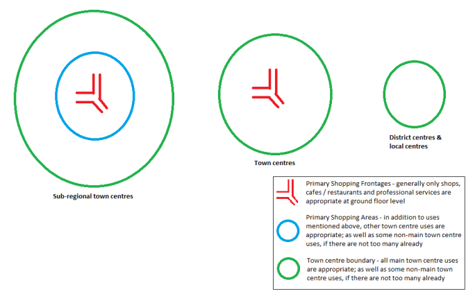
EC10 Development for main town centre uses outside Buckinghamshire’s centres.
Policy EC10: Development for main town centre uses outside Buckinghamshire’s centres.
1.Proposals for main town centre uses that are greater than 400sqm gross and are not within defined centres must follow the sequential test, as set out in the NPPF and PPG. Where the sequential test indicates there are one or more suitable alternative sites to the proposal site within a town centre or on the edge of a town centre, development will be refused in line with national policy.
2.Furthermore, proposals for main town centre uses that are greater than 400sqm gross and are not within defined centres must also be subject to the impact test, as set out in the NPPF and PPG. Where the impact test indicates significant adverse impacts on an existing centre, development will be refused.
3.Proposals for new small shops (up to 400sqm) or extensions to existing shops within or adjacent to existing settlements that serve local needs will be supported.
7.125Shops in centres provide a vital role in supporting the sustainability of settlements, reducing the need for residents to travel to meet day-to-day needs. Retail and other main town centre uses are directed towards our existing centres. In smaller settlements, they also provide an important community function, forming a hub for village life and supporting those who have difficulty travelling. Proposals for small-scale new shops and facilities to serve local needs are supported by the plan.
7.126There are benefits to the clustering of retail and other main town centre uses within centres – a cluster of complementary uses creates an attractive destination that allows residents to shop for different things, go for a drink or meal and the cinema all in one place. The impact and sequential tests in this policy seek to ensure that new development for retail and main town centre uses are in existing centres and do not have significant impacts on their vitality and viability. The thresholds set out in this policy are informed by evidence that the small scale of many of Buckinghamshire’s centres means that they are vulnerable to out-of-town proposals.
7.127Proposals for main town centre uses in out of centre locations that pass the sequential and impact tests should be in locations that are well served by public transport and accessible by active travel routes. This will still allow these uses to support sustainable travel choices.
7.128Future stages of the plan will consider mixed use allocations; these will include an element of main town centres uses. It will not be necessary to apply the sequential and impact tests within policy EC12 to main town centre uses proposed within allocations in the plan.
The Council will support the creation of inclusive and accessible centres that can be used safely and independently by all members of the community, including older people, disabled people, families with young children and other groups with accessibility needs. Development proposals should have regard to the Buckinghamshire Design Code, which includes provisions relating to accessibility, movement, legibility, wayfinding and the design of public spaces. The Council will seek to ensure that development contributes positively to an accessible, legible and welcoming town centre environment for all users.
7.129Natural Environment
NE1 - Water quality
Policy NE1: Water quality
Effects of development
- Development proposals will only be supported where they will not adversely affect the water quality of surface or underground water bodies (including rivers, canals, lakes, reservoirs, drinking water safeguard zones, source protection zones and groundwater aquifers). Development proposals should identify opportunities to improve water quality and groundwater quality where possible.
- Development proposals affecting designated sites, priority habitats and species and their water catchment will need to demonstrate how water quality will be maintained, minimise surface water drainage and reduce pressure on the wastewater network.
- Where there are potential adverse effects from windfall site development, developers must have full regard to the council’s latest Water Cycle Study. Development proposals must demonstrate how potential adverse impacts on water quality will be mitigated. In addition, the timing of development must consider the water infrastructure provider upgrades so a watercourse can treat wastewater to a higher standard.
- A Water Framework Directive assessment is required when there are potential adverse impacts of development on a waterbody. This includes the potential of the development to prevent achievement of good ecological and chemical status of the waterbody in the future.
Drinking Water Safeguard Zones and Source Protection Zones
5. In order to protect and improve water quality, potentially contaminating developments affecting principal aquifers, including the Chalk Aquifer, or within the county’s Drinking Water Safeguard Zones (surface water) or Source Protection Zones (groundwater) as defined by the Environment Agency and water companies, will need to demonstrate that surface water and groundwater are adequately protected to prevent a deterioration of water quality and pollution of the water source.
6. Sustainable Drainage Systems (SuDS) for developments located within Drinking Water safeguard zones and SPZ must carefully consider the risk of contamination to both surface and ground water sources and ensure appropriate mitigation measures are implemented to minimise impacts.
7. Developments which fall within a Groundwater Source Protection Zone will be required to be designed to allow for all the following:
a) The potential to encounter shallow groundwater and the restriction on the use of soakaways.
b) Avoiding direct discharge of hazardous substances to groundwater and prevent the input of pollutants and non-hazardous substances to groundwater.
c) The potential for historic contamination to be encountered during development.
d) Restrictions on deep penetrative foundation methods if contamination is encountered.
7.135Development affecting waterbodies are expected to contribute to achieving the Water Framework Directive (WFD) objectives for these waterbodies. River Basin Management Plans are an Environment Agency tool used to deliver the WFD objectives and Buckinghamshire Council has an obligation to have regard for such plans.
7.136It is important that water quality and quantity is maintained and enhanced by avoiding adverse effects of development on the water environment. Population growth and new housing are increasing pressure on waterbodies, including chalk streams, through changes in land use, demand for water, water quality and habitat loss. To reduce the impact of development, adequate infrastructure should be in place to ensure there is no increase in unsustainable abstraction or overloading of the sewer network or sewage treatment infrastructure. Mitigation responses include buffering development alongside chalk streams and implementing adequate management of runoffs (see also policies CC1 and CC2) including the use of infiltration and deep borehole SuDS to aid chalk aquifer recharge.
7.137There are many opportunities for improving the ecological condition of waterways and the following examples will be particularly encouraged:
- locating open space next to rivers
- retaining river habitat as public space
- designing schemes that positively integrate with river corridor habitats.
- maximise health and wellbeing capacity of access to natural watercourses.
- integrating flood attenuation with landscape and biodiversity enhancements
- utilising bio-engineering solutions and avoiding hard bankside engineering.
- restoring natural river courses and corridors where these were previously modified, culverted or channelled (see policy NE2 Watercourses and associated corridors)
- incorporating features to support aquatic wildlife including fish and working with relevant river catchment partnerships to identify the most appropriate enhancements for watercourse habitats.
7.138Many designated sites, priority habitats and species are dependent on good water quality particularly those that are water-dependent and hydrologically linked to groundwater and surface water bodies. These habitats will be sensitive or burdened from water quality pressures such as nutrient enrichment and increased pollutants. The policy requires stringent protection of the water quality in the catchment as this will help to prevent deterioration, maintain and/or restore the condition of water dependent designated sites (and wider) within the landscape. Information on the categories of designated or protected sites can be found here Protected sites and areas: how to review planning applications - GOV.UK.
7.139Measures to minimise surface water drainage and reduce pressure on the wastewater network are identified in the latest Water Cycle Study. These should be used in the case of impacts on designated sites. The measures include greater use of Sustainable Drainage Systems, maximising surface water infiltration contributing to watercourse catchment-wide measures aimed to slow water flows.
7.140Drinking water safeguard zones (surface water). Drinking Water Safeguarding Zones (WSZs) are the areas at risk of failing the drinking water protection objectives of the Water Environment (Water Framework Directive) (England & Wales) Regulations 2017. WSZs define areas where actions and measures will be targeted to address water contamination and avoid or minimise extra treatment needed by water companies. Actions proposed for each DWSZ are provided in Actions Plans produced by the Environment Agency with the water companies.
7.141In Buckinghamshire’s DWSZs, the following general guidance applies to the use of SuDS:
|
SuDS Type |
Guidance for Drinking Water Safeguard Zones in Buckinghamshire |
|
Infiltration SuDS (e.g., soakaways, infiltration basins) |
Not permitted in SPZ1 and avoided in SPZ2 unless proven safe. Lined or engineered alternatives preferred. |
|
Permeable paving |
Use only with impermeable liners in sensitive groundwater areas. |
|
Detention basins / wetlands |
Allowed with proper treatment. Avoid direct infiltration. Ensure sufficient retention time. |
|
Swales, filter strips |
Acceptable for surface water pre-treatment. |
|
Green roofs |
Low risk; acceptable in all locations. |
7.142The Environment Agency has designated in certain areas of Buckinghamshire Source Protection Zones (groundwater) for clean water supply, and principal aquifers, (including the chalk aquifer) which are sensitive receptors. Potential risks to these receptors come from contaminated land with past historic uses of some sites. In other cases, it can be linked to pollutants in surface water which infiltrate to the groundwater table.
7.143Source Protection Zones (SPZs) are categorised into three zones, 1-3, with one being most sensitive to pollution, and three representing the lowest risk but still within the groundwater catchment of the abstraction. The Environment Agency’s Manual to Produce Groundwater Source Protection Zones[7], details position statements which provide information about the Environment Agency's approach to managing and protecting groundwater. Proposed development locations within or close to Source Protection Zones, should be assessed in relation to the relevant Environment Agency position statements.
7.144All developments should consider the sensitivity of the underlying Chalk Aquifer and the large number of public water abstractions in the areas protected by Source Protection Zones.
7.145In considering SuDS solutions, development proposals must consider the need to protect surface water and groundwater quality, especially where infiltration techniques are proposed. SuDS which contribute to removing pollutants, and to managing flows, will be strongly preferred. See SuDS in Source Protection Zones guidance: suds-in-spz-guidance.pdf
NE2 - Watercourses and associated corridors
Policy NE2: Watercourses and associated corridors
1. Development is required to conserve and enhance the functions and setting of any affected watercourse and associated corridor through good design, including in terms of biodiversity, landscape, flood management and recreational/amenity value.
2. Opportunities for de-culverting and re-naturalising watercourses and removing fish passes shall be actively pursued where development sites contain or are adjacent to watercourses. Where this is clearly demonstrated not to be possible, s106 contributions will be sought to help enable enhancement works on areas of a watercourse in the vicinity. Contributions will be commensurate to the de-culverting or re-naturalising opportunity that could not be taken.
3. Proposals will only be supported where they do not involve the canalising or culverting of watercourses and do not prejudice future opportunities for de-culverting / re-naturalising.
4. Development proposals for new development adjacent to or containing a watercourse are required to provide or retain at least a 10 metres natural buffer between the top of the watercourse bank and the development, with no lighting, and include a long-term landscape and ecological management plan (or habitat management and monitoring plan) for this buffer. Where the watercourse is a Chalk Stream or a ditch connected to a chalk stream, as listed in this policy, this natural buffer must be at least fifteen metres.
5. Chalk streams (including headwaters) (as indicated in the Local Nature Recovery Strategy Mapping) in Buckinghamshire are:
- Hamble Brook
- Hughenden Stream
- River Chess
- River Misbourne
- River Wye
- River Colne
- Alderbourne
- Escarpment chalk streams
6. A long-term management plan must be in place for the watercourse and its buffer zone within the control of the development including the management of invasive non-native species. The management plan must be in accordance with the river catchment management plan (and other more specific plans) In new developments, publicly accessible space must be designed to include existing watercourses to ensure adequate access for maintenance of the watercourse.
7.146Policy NE2 emphasises the importance of conserving and enhancing watercourses, as part of improving the wider water environment (see also policy NE1 on water quality). Watercourses and their associated corridors are a vital element of the Green and Blue Infrastructure of Buckinghamshire. They have several valuable functions – as a landscape and amenity feature, for biodiversity as a habitat and as a corridor to allow movement of species, for flood management, for recreation, as a water resource and to allow access for river maintenance. Enhancements and improvements to river habitats and their buffers will provide resilience to climate change.
7.147In terms of 5 (g) Escarpment chalk streams are found along the north-west facing side of the Chiltern Hills. They are fed by groundwater and originate along the spring-line at the base of the Chiltern escarpment. The spring-line occurs where the Chalk aquifer discharges at the junction with underlying or adjacent less permeable strata (notably the Upper Greensand and Gault Clay).
7.148The Local Nature Recovery Strategy mapping identifies the location of chalk streams and rivers in Buckinghamshire. It does not show sections of streams and rivers which are underground due to culverting, however this policy does apply to underground sections.
7.149This policy covers Main Rivers (as defined by the Environment Agency), ordinary watercourses, and canals. Ordinary watercourses are any channel / passage of water through which water flows, which do not form part of a Main River. They can include streams, ditches, drains, mills, dams, culverts and weirs.
7.150Of particular importance in the county are the River Wye, River Chess, River Misbourne, River Colne, Hamble Brook, Alderbourne and their tributaries as these are chalk streams which are a globally rare habitat that has been designated as a priority habitat within the UK Biodiversity Framework. Additionally, the River Thames has a nationally important landscape value.
7.151Opportunities for the built environment involving watercourses include creating attractive places where people want to live, work and play through making space for water and green spaces in the built environment. They can also provide cost-effective infrastructure that uses fewer natural resources and has a smaller whole-life carbon footprint. One of the aims of the policy is to help create developments that are more able to cope with changes in climate, protecting people and property from increased flood risk from climate change.
7.152Some watercourses have been altered in some way by either straightening the channel, replacing natural banks with hard engineering, dredging or widening. These changes over time have led to the loss of natural features such as bankside habitats, gravel riffles, pools and meanders, and in many cases, banks have been increased in height, disconnecting the watercourse from its floodplain.
7.153Developments which contain or are adjacent to watercourses offer an opportunity to provide ecological buffers, restore bankside and in-stream habitats, create pond complexes and natural floodplains. Carefully designed developments along watercourses can increase the ecological and biodiversity value of the features within them, and the value of the overall development.
7.154Canalising is the use of hard engineering (including walls, piles, gabions and plastic geo-bags) to create structure instead of more natural riverbank.
7.155Developers will need to refer to the detailed Lead Local Flood Authority (LLFA) information on the website regarding responsibilities and requirements for Consents / Permits prior to work on any watercourse being undertaken. Early engagement with the LLFA should also be pursued for works in and around ordinary watercourses. https://www.buckinghamshire.gov.uk/environment/flooding-and-flood-risk-management/
7.156The policy requires a 10m buffer (except for chalk streams – see below). Where the watercourse flows through a development site, the buffer is required on both sides of the channel. This width of buffer provides the minimum width of habitat needed to provide for the functioning of wildlife habitats, while being able to facilitate informal access for enjoyment of the river (see VALP watercourse advice note on the website for more details). This width also ensures that the river is buffered from land-based activities, e.g. reducing the levels of diffuse pollution reaching the watercourse. Furthermore, this buffer allows for ease of access for maintenance of the watercourse to ensure flood risk is not increased due to lack of maintenance and/or blockage. Developers are encouraged to engage early on with the council to understand what is appropriate for inclusion within the buffer strip. The buffer zone is also a riparian zone highlighting its importance for biodiversity and habitat.
7.157Development can enable good opportunities to increase public access to rivers and riverbanks. Increasing public access provides a great opportunity to engage the public and connect people with nature. This should be achieved in an environmentally sensitive manner to ensure biodiversity is not adversely affected by human activity.
7.158Buffer zones should be of natural character, free from built environment (including paths, roads, residential gardens and play areas), with no light pollution greater than two lux and a warm white’ colour temperature of 2700k or less (see also policy NE10 Mitigating light impacts).
7.159The importance and vitality of chalk streams to Buckinghamshire's Chilterns Landscape cannot be underestimated. Chalk rivers and their ecosystems provide a unique habitat for fish, animals and plants. Healthy chalk streams are the most biodiverse of rivers. They face increasing pressure from climate change, population growth and development, pollution and abstraction. Ensuring no further deterioration from current baselines involves affording them stronger policies for their protection.
7.160Within the Chilterns National Landscape and it is setting please also see the Chilterns Chalk Streams Planning Guidance (2025 as replaced). This guidance offers a way forward; a set of practical recommendations for planners, developers, and communities to ensure these precious rivers are properly considered and protected in the planning system.
7.161Chalk-stream ecological health depends on three factors.
- water quantity (the naturalness of the flow regime)
- water quality (how clean the water is)
- physical habitat quality (the physical shape of the river, but incorporating biological factors like invasive species which can degrade habitat directly and indirectly)
7.162Chalk streams are also highly dependent on the geomorphology and biodiversity of the riverbank, necessary to maintain the condition of the chalk habitat and the species it supports. As a result, a wider buffer of a minimum of fifteen metres is required for designated Chalk streams and their headwaters. This zone should extend further than 15m where necessary in line with the natural flood plain. Where development is proposed in areas close to modified chalk streams, planning can help to seek to return the river to a more natural state. Other consents/ permits from the relevant authorities will still apply.
7.163Opportunities to expand ecological buffers, corridors or stepping stones such as existing riparian vegetation that link up with existing green infrastructure should be maximised.
7.164The policy requires a Water Framework Directive assessment where development could have an adverse impact on the water body. This is because development adjacent to watercourses are expected to contribute to achieving the Water Framework Directive objectives. River Basin Management Plans are a tool used to deliver the WFD objectives and Buckinghamshire Council, water companies and developers have an obligation to have regard to such plans.
Policy NE3 - Development involving or affecting canals.
Policy NE3: Development involving or affecting canals.
- Development alongside canals
- Must not impede public access, ensuring public access is retained and where possible enhanced. Such access will consider the need for any easements or buffers to the canal edge for maintenance or to reduce the likelihood of canal flooding.Where possible retain and enhance significant waterside buildings and their settings
- Retain the provision of moorings and enhance moorings where the need is demonstrated.
- Retain wharf facilities for freight transfer where a need is demonstrated and support the use of canals for waterborne freight
7.165Buckinghamshire has a significant canal network which in several cases form part of regional and national networks. The key canals in Buckinghamshire are:
- Grand Union Canal - Aylesbury Arm: A 6.25-mile canal with sixteen locks that branches off from the main Grand Union line at Marsworth Junction to Aylesbury. It offers scenic walking, fishing, and boating, leading to a vibrant canal basin with marina and boating facilities in Aylesbury.
- Wendover Arm (Grand Union Canal): Originally opened in 1799, this 6.7-mile arm runs from Bulbourne to Wendover. It is known for its rural charm and is undergoing restoration, with sections now open to walkers and small craft.
- Buckingham Canal (Old Stratford Arm): A former canal running from Cosgrove to Buckingham. While partially abandoned, the Buckingham Canal Society is actively working to restore the nine-mile route, providing nature-rich walking paths in parts.
- Grand Union Canal Main Line: While not exclusively in Buckinghamshire, significant sections of the main line run through the county, particularly around Marsworth, featuring flight locks and reservoirs.
7.166The Canal & River Trust is the primary charity responsible for the maintenance, protection, and management of Buckinghamshire's canals, including the Grand Union Canal and the Aylesbury Arm. They maintain structural integrity, improve biodiversity, manage water quality, and promote the waterways for boating, tourism, and community wellbeing. The Trust will be a key stakeholder in planning for development affecting canals.
7.167Canal user groups in England represent a diverse mix of boaters (including those needing longer term residential moorings), walkers, cyclists, anglers, and local community members. These groups actively collaborate with navigation authorities including the Canal & River Trust to advocate for specific interests, maintain heritage sites, and plan waterway activities.
7.168Waterborne freight as a mode of sustainable transport has potential health and carbon emission reduction benefits in line with Canal River Trust guidance. It can also help with the sustainability benefits of a modal shift away from road transport. In recent years there has been a growing interest in the potential for freight traffic as fuel costs have risen an awareness of the environmental benefits of freight by water.
NE4 - Biodiversity – protection and enhancement of sites and habitats of high biodiversity and geodiversity importance
Policy NE4: Biodiversity – protection and enhancement of sites and habitats of high biodiversity and geodiversity importance
- Development proposals must demonstrate how they will avoid adverse impacts on sites of nature conservation or geological interest. This policy applies to sites at all levels of importance including:
- international and national statutory designated sites,
- locally (non-statutory) designated sites of county importance,
- habitats of principal importance (as listed in section 41 of the Natural Environment and Rural Communities (NERC) Act 2006)
- All development proposals in or potentially affecting a designated site or priority habitat must be supported by robust, proportionate and relevant, ecological desk studies, surveys and impact assessment, produced by suitably qualified and experienced professionals in line with published industry best practice guidance.
- The highest level of protection will be given to sites of international and national importance. Considerable weight must be given to their protection.
- Development proposals that would directly or indirectly harm statutory designated sites, will not be permitted, except for in exceptional circumstances. If significant harm resulting from a development cannot be avoided (through locating on an alternative site with less harmful impacts), adequately mitigated, or, as a last resort, compensated for, then planning permission will be refused.
- Development proposals that would directly or indirectly harm locally (non-statutory) designated sites of county importance, will only be supported where it has been demonstrated that all the following apply:
- there could be no suitable alternative site for the proposed type of development, (and this has been demonstrated through a sequential site assessment, prioritising avoidance of ecological harm) and
- the need for and benefits of the development clearly outweigh the harm to the ecological or geological interest of the site, having regard to its importance and the extent of impact and
- the benefits are clearly and demonstrably of greater significance than the ecological or geological value of the site.
- it has been clearly demonstrated that the wider benefits of the development to the public, outweigh the harm to the biodiversity or geological conservation interests.
- the intrinsic natural features of particular interest are safeguarded and enhanced following the mitigation hierarchy. Ecological impacts are avoided or minimised, and those impacts which cannot be, will be mitigated and compensated for through a 2:1 area ratio and ‘like for better’. Compensation and enhancement should be on site, or as a last resort within the local ecological network. The retained, compensated and enhanced areas must be provided for through funded long term ecologically appropriate management and align with the specific priorities detailed in the Local Nature Recovery Strategy Statement of Biodiversity Priorities.
- Development proposals that would directly or indirectly harm habitats of principal importance (also known as priority habitats) will only be supported if c), d) and e) of the above section applies.
- Development proposals must seek to advance the priorities and measures of the Local Nature Recovery Strategy, both those which are mapped and coincide with the site as well as unmapped measures.
- Sites of high biodiversity or geodiversity importance will be protected and enhanced via the use of appropriate buffers of natural habitat. The size of the buffer will be relative to the geographic scale of importance of the site, and habitat type. The buffer will provide protection during and post construction, as well as secure long-term enhancement of ecological functionality. Appropriate buffers will be case specific but will be a minimum of:
- Fifty metres for Sites of Special Scientific Interest (SSSIs)
- Fifty metres from ancient woodland unless local circumstances justify otherwise,
- Thirty metres for sites of local importance. Development proposals in or potentially affecting a site / habitat of county importance must be accompanied by ecological survey results and a report identifying how a site performs against the Local Wildlife Site Selection Criteria for Buckinghamshire. The findings will need to be verified by the council’s ecologists. To enable verification, access to the land must be given to the council’s ecologists and any specialist assistants they require, during the survey season. Should the site meet the Local Wildlife Site Selection Criteria for Buckinghamshire, it will be given the same consideration in decision making as if they were designated.
- The council will use planning conditions to secure biodiversity enhancements to deliver this policy where on site or Section 106 Agreements where off site. A monitoring and management plan will be required for biodiversity features to ensure their long-term suitable management (secured through planning conditions or Section 106 Agreement).
7.164The conservation and enhancement of the natural environment is a core objective of the Local Plan and an essential component of the measures to mitigate climate change.
7.165Biodiversity gain and nature recovery are integral to sustainable development and delivering other services to people and the environment. Biodiversity is the variety of life on earth, including plants and animals, the variety within and between species, and the diversity in ecosystems (the complex systems formed by interactions between living things and the inanimate world). Geodiversity is defined as the variety of rocks, minerals, fossils, soils, landforms and natural processes.
7.166Designated sites, important habitats (and protected species -see policy NE4) form a vital part of the biodiversity and geodiversity resource of the county. The Council supports the creation, restoration, retention, protection and extension of all areas designated internationally, nationally and locally as well as all Habitats and Species of Principal Importance within the county.
7.167This policy applies to the following:
Sites / habitats of national importance
- Special Areas of Conservation (SAC)
- National Nature Reserves (NNR)
- Sites of Special Scientific Interest (SSSI)
- Designated Chalk Streams
Sites / habitats of county importance
- Local Wildlife Sites (LWS)
- Biological Notification Sites (BNS) and potential Local Wildlife Sites
- Local Nature Reserves (LNR)
- Local Geological Sites (LGS)
- Ancient Woodland, ancient or veteran trees
7.168UK Biodiversity Action Plan (BAP) Priority Habitats (Habitats of Principle Importance defined in the Natural Environment and Rural Communities Act (2006) as amended by subsequent legislation).
7.169For clarity, all habitats and sites covered under the Buckinghamshire and Milton Keynes’s Local Nature Recovery Strategy (LNRS) as Areas of Particular Importance in the LNRS mapping are covered by this policy.
7.170The policy sets out a buffer for SSSIs of fifty metres and thirty metres for local sites.
7.171The policy also sets out a buffer for ancient woodlands, in line with the Woodland Trust guidance; it will be for applicants to demonstrate the justification for any smaller buffer, or other equivalent mitigation measures in accordance with best practice guidance to ensure that the ancient woodland is not harmed.
7.172Standing advice from Natural England and the Forestry Commission states that at least fifteen metres buffer should be provided for root protection but that other impacts are likely to require greater buffers. The size and type of buffer zone should vary depending on the:
- scale and type of development and its effect on ancient woodland.
- ancient and veteran trees character of the surrounding area.
7.173For example, larger buffer zones are more likely to be needed if the surrounding area is:
- less densely wooded
- close to residential areas
- steeply sloped
7.174Where a planning application comes forward which would impact upon a BNS, the application must come forward with an assessment of the site against the LWS criteria:
- if the site is considered (and agreed with the LPA) to meet the criteria it will be a 'potential LWS' and will be considered in policy terms as if it were an LWS,
- if it does not meet the criteria (and this is agreed with the LPA), the site will not be considered as worthy of LWS importance for the planning application and the removal of the BNS designation will be considered at the next LWS selection panel.
- At the time of submission of development proposals, survey data must be passed to the Buckinghamshire Milton Keynes Environmental Record Centre in a suitably formatted excel spreadsheet.
NE5 - Biodiversity protection and conservation of species
Policy NE5: Biodiversity protection and conservation of species
- This policy seeks to ensure appropriate consideration is given to species which are protected by statute at the international and national level, those which are, species of principal importance (priority species) as listed in section 41 of the Natural Environment and Rural Communities (NERC) Act 2006 and species suffering significant declines.
- Development proposals must, having regard to relevant statutory requirements:
- consider the reasonable likelihood that protected, priority or declining species could be directly or indirectly impacted upon,
- (where there is a reasonable likelihood of presence) be supported by proportionate, robust and relevant, ecological desk studies, surveys and impact assessment, produced by suitably qualified and experienced professionals in line with published industry best practice guidance,
- sufficient survey effort has been undertaken to understand the presence, distribution and use of the site by relevant species.
- demonstrate how the design has been informed by ecological information and how the mitigation hierarchy has been followed sequentially, so that the avoidance, minimisation and compensation for impacts have been embedded into the design.
- consider how species priorities identified in the Local Nature Recovery Strategy can be supported.
- compensate for any residual impacts upon species at a minimum of 2:1 basis, so that the resources are provided to support a greater number of identified species.
2. The council will use planning conditions to secure mitigation, compensation and enhancements for species to deliver this policy where on site or Section 106 Agreements where off site. A monitoring and management plan may be required for significant species features to ensure their long-term success.
7.145Protected species include those identified in the following legislation (other legislation also contains information about protected species):
- Conservation of Habitats and Species Regulations 2017
- Wildlife and Countryside Act 1981 (as amended)
- Protection of Badgers Act 1992
7.146The council has a duty under section 40 of the NERC Act to consider the conservation and enhancement of biodiversity through carrying out its functions; therefore, development proposals must be accompanied by the council’s checklist which must be accurately completed so that known information about biodiversity which could be impacted upon by proposals is shared.
7.147It is essential that the presence or otherwise of protected species, and the extent that they may be affected by the proposed development, is established before the planning permission is granted, otherwise all relevant material considerations may not have been addressed in making the decision.
7.148Many species suffering significant declines are included within section 41 of the Natural Environment and Rural Communities (NERC) Act 2006. However, not all species which are declining are identified within section 41. Therefore, where species are found during surveys which are listed as threatened on Great Britain Red Lists, (including those classified as Critically Endangered, Endangered or Vulnerable, species included on Birds of Conservation Concern Red and Amber Lists, species identified in recognised taxonomic Red Data Books or conservation status assessments), they should also be subject to consideration for how they can be protected and enhanced through following the mitigation hierarchy. Together these species are sometimes called ‘notable species.
7.149Those habitats and species which are of principal importance for nature conservation are included as ‘priority habitats and species’ in the England Biodiversity List published under section 41 of the Natural Environment and Rural Communities Act 2006. Developers should consult the Habitats and species of principal importance in England for a list of priority habitats and species in England. Many priority habitats have been mapped on the MAGIC maps website (https://magic.defra.gov.uk/MagicMap.html), and the Buckinghamshire Milton Keynes Environmental Records Centre (https://www.bucksmkerc.org.uk) holds additional maps of Priority Habitats they have identified. It should be noted that there is no complete map of the presence of Priority Habitats or Species and so care must be taken to identify them on any site of interest. The LPA will need to consider priority habitats and species when applying its ‘biodiversity duty’ to the policy.
7.150Protected species are those species protected under domestic or European law. Further information can be found in Natural England’s standing advice for protected species. Habitats that may support protected species include, but are not limited to, sites containing watercourses, old buildings, significant hedgerows and substantial trees.
7.151To comply with part 1 of the policy, surveys should be done prior to determining the application. Surveys and reporting must be undertaken in accordance with the relevant best practice guidelines and undertaken by suitability experienced and qualified professionals.
7.152Buckinghamshire Council holds a Great Crested Newt Organisational (or ‘District’) Licence granted by Natural England. The associated District Licensing Scheme, which is currently administered and managed by NatureSpace Partnership, provides an alternative licensing option for developers to address impacts on protected great crested newts by enabling a ‘conservation payment’ towards high quality habitat creation and long-term management and monitoring.
7.153In the District Licensing Scheme, developers can engage with NatureSpace at the pre-application stage or at the planning application stage. It is based on a great crested newt landscape-scale conservation strategy, which aims to focus the creation of new habitats where they will be of maximum benefit to the species, whilst also reducing risk and uncertainty through the planning process for developers and planning authorities. The strategy results in a range of other biodiversity benefits and contributes towards nature recovery at the landscape scale.
NE6 - Biodiversity gain and nature recovery
Policy NE6: Biodiversity gain and nature recovery
1. All development proposals should consider how to maximise biodiversity by conserving, enhancing or extending existing ecological resources or creating new areas or features, tailored to the priority habitats and protected species present within the site and surrounding area. Opportunities to create, expand, enhance or link ecological networks and deliver opportunities identified in the latest Local Nature Recovery Strategy should also be considered.
2. Where potential biodiversity interest is identified on a site or the development creates an opportunity to increase biodiversity, the Council will require an ecological survey and report to be submitted which demonstrates how biodiversity will be protected and enhanced.
3. All development not subject to an exemption for Biodiversity Net Gain requirement under national regulations should achieve the following percentage of biodiversity net gain:
- Ten percent if delivered on site.
- Ten percent if delivered off site within Buckinghamshire.
- Twenty percent if delivered off site outside of Buckinghamshire.
4. Calculations are required to use the most recent Statutory Metric
5. Habitat enhancements should be designed to provide significant contributions to nature’s recovery in line with the latest Local Nature Recovery Strategy.
6. Net gain should be achieved in line with the biodiversity gain hierarchy. Where Biodiversity Gain Sites are used, they should be located close to the development. In situations where this is not considered possible or appropriate, then alternative arrangements must be clearly set out and justified, the last resort is to purchase statutory biodiversity credits.
7. Where proposals involve the creation of significant habitat creation/ enhancement which are integral to development, they should be accompanied by a long-term management and monitoring plan which must be approved by the Local Planning Authority.
7.154All development presents an opportunity to contribute to the conservation, enhancement and restoration of biodiversity. In line with national policy, proposals should apply the mitigation hierarchy by avoiding harm in the first instance, then mitigating and compensating for impacts, and delivering measurable net gains wherever possible. This approach supports the creation of resilient ecological networks, consistent with the Lawton principles of ‘bigger, better, more and more joined’.
7.155Development proposals should seek to strengthen ecological connectivity within and beyond site boundaries. This may be achieved through measures such as the retention and enhancement of existing habitats, the creation of new habitat features, and the provision of connected green infrastructure including hedgerows, watercourses and stepping-stone habitats. These measures are particularly important in supporting mobile species and improving overall ecosystem resilience.
7.156The policy applies to all developments, unless they are exempted under national regulations.
7.157As stated in Buckinghamshire’s Strategic Vision to 2050[8], the Council encourages developments which trigger the mandatory requirement for BNG to achieve a 20% biodiversity net gain.
7.158The policy seeks to achieve BNG delivery on site and off site within Buckinghamshire as a priority, a greater percentage off site is required outside of Buckinghamshire to reflect this.
7.159The Council supports the objectives of the Buckinghamshire and Milton Keynes Local Nature Partnership (known as the NEP), including their commitment to a doubling of nature: working towards a doubling of the land in Buckinghamshire is positively managed for wildlife and nature-base solutions.
7.160As part of refining the local plan including site allocations, the Council has considered how the areas mapped and identified in the Buckinghamshire and Milton Keynes Local Nature Recovery Strategy and the measures proposed in them should be reflected in the local plan. In doing so, we are considering what safeguarding would be appropriate to enable the proposed actions to be delivered, noting the potential to target stronger safeguarding in areas the local planning authority considers to be of greater importance. This will enable the Council to support the best opportunities to create or improve habitat to conserve and enhance biodiversity, including where this may enable development in some locations.
7.161When taking decisions, the Council will have due regards to the objectives, priorities and measures of the latest adopted LNRS, which are material considerations. LNRSs provide a robust evidence base for opportunities for nature recovery, informing Local Plans and Neighbourhood Plans, and the proposed new Spatial Development Strategies. They are not intended to provide red line boundaries preventing or placing new restrictions on land use which may be changed either through development or in taking advantage of new opportunities identified through the strategy. This has been established by national guidance. Development Plans remain the primary tool used by local planning authorities to determine which land should be developed and how.
7.162The Buckinghamshire and Milton Keynes LNRS can be found on the Buckinghamshire and Milton Keynes Natural Environment Partnership (the area’s Local Nature Partnership which produced the LNRS on behalf of the Council) website: https://bucksmknep.co.uk/nature-strategy/
7.163The Buckinghamshire and Milton Keynes Local Nature Recovery Strategy 9 themes are:
- Conserve, create, enhance and restore land-based habitats.
- Improve rivers, their floodplains and the quality of their waters.
- Conserve, create, enhance and maintain wetland habitats.
- More farmers and rural land managers to adopt wildlife-friendly land management practices and take action to improve soil health.
- Improve biodiversity in built-up areas.
- Create connections between high-quality areas for wildlife and habitats to flourish.
- Manage the effects of a changing climate and improve air quality.
- Tackle non-native invasive species, pests and diseases.
- Improve the environment for rare, specialist species.
7.164The Buckinghamshire and Milton Keynes Biodiversity Action Plan[9] to 2030 remains in place for the time being, as it forms part of the evidential basis for the LNRS. When developing this plan, the Council is therefore also taking into consideration the aims and principles for existing Biodiversity Opportunity Areas.
7.165The Council will also have regards to other partners’ plans such as the Chilterns Conservation Board’s Nature Recovery Plan.
7.166The management of natural areas and newly created sites to be an integral part of the development will require an endowment or some other means to support maintenance and longer-term future. This may include the creation of Biodiversity Net Gain units. The stewardship arrangement and the potential need for off-site BNG units should be discussed with the local planning authority at the earliest date since it may affect the design and nature of proposals for the natural environment and Biodiversity Net Gain requirements on the site.
7.167In assessing Biodiversity Net Gain, the Council will consider proposals against the BNG hierarchy as set out in the BNG Framework. BNG should be assessed using the latest statutory metric.
7.168Seeking advice from a suitably qualified ecologist on the ecological enhancements selected is encouraged. The chosen measure(s) will need to be clearly highlighted on landscape and elevation plans and/or within the design and access statement. In addition, all new tree and soft landscaping must incorporate an element of native planting, and where non-native planting is proposed this should comprise species beneficial to UK pollinators and/or chosen to be well-adapted to future changes in climate. Proposals incorporating invasive plant species will not be supported.
7.169Significant habitat enhancement includes habitats of medium or higher distinctiveness, creates many biodiversity units relative to the baseline, is of a large area or enhances habitats to ‘good’ condition.
7.170The Local Planning Authority will require a biodiversity monitoring contribution to review progress towards the creation of significant habitat enhancement over the management period where it is of a scale or technicality that the monitoring would be reasonable to ensure the proposed ecological outcomes are achieved. For example, a nature reserve or an area of priority habitat.
7.171All maintenance and management requirements of the proposed enhancements must be specified within planning applications and secured via planning conditions. Management plans should be for a period of at least 30 years (where used for BNG) and often in perpetuity (where the habitats form an integral part of the development’s green infrastructure) or planning obligations, as appropriate.
7.172As they set opportunities for habitats creation and enhancement at landscape-scale, Local Nature Recovery Strategies can inform the strategic delivery of offsite biodiversity gain in the right places, where offsite provision is needed to meet the biodiversity gain condition for a development and it cannot be met in full through onsite habitat enhancements. The Council will continue to work with landowners to develop a pipeline of Biodiversity Gain Sites which deliver the best outcomes for nature’s recovery within Buckinghamshire and ensure that a local supply of biodiversity gain units is available for developers.
7.173Following the Local Nature Recovery Strategy, a “strategic significance” uplift can be applied post-intervention if:
- The intervention is in a location where a LNRS potential measure has been proposed and
- the intervention is consistent with the potential measure proposed in that location.
NE7 - Green Infrastructure
Policy NE7: Green Infrastructure
1. Development should deliver high-quality Green Infrastructure (GI) that performs multiple functions and provides a wide range of benefits, including for biodiversity, water quality and flood management, health and wellbeing, recreation, access to nature, and climate change adaptation. Proposals that enhance and expand green infrastructure will be supported
2. For residential developments of more than ten dwellings or with a combined gross internal floorspace exceeding 1,000 sqm, proposals must:
a) Respond to local context by demonstrating an understanding of existing GI assets and identifying how the development will enhance and extend these networks. This should be informed by relevant published evidence and local assessment.
b) Meet Natural England’s Accessible Green Space (AGS) standards set out in Appendix M to address the additional demand generated by the development.
3. A Green Infrastructure Statement must be submitted and approved, setting out how the proposal integrates with, enhances the local GI network, and satisfies AGS requirements.
4. Development must:
a) Provide on-site amenity green space as part of AGS provision.
b) Deliver formal sports, play, and allotment facilities as appropriate, either on- or off-site, on land additional to AGS provision, ensuring these facilities complement the wider GI network.
c) Ensure that any green space counted towards AGS standards meets the definitions of ‘accessible’ and ‘natural’ as set out in supporting text.
5. Accessible green space to meet the standards in Appendix M should be provided on-site or off-site unless it is robustly demonstrated, through assessment, that existing provision (taking account of the development and committed schemes) already meets the required standard.
Management and Maintenance of GI
6. Green infrastructure being provided must have a long-term management and maintenance strategy to be agreed by the council with assets managed for at least 30 years after completion and during this time secure a mechanism to manage sites into perpetuity. The management and maintenance strategy shall set out details of the owner, the responsible body and how the strategy can be implemented by contractors.
Definition of Green Infrastructure
7.174National planning policy sets out that Local Plans should take a strategic approach to maintaining and enhancing networks of habitats - for wildlife - and green infrastructure – for people, recognising the wide range of benefits that such green spaces can provide. This policy expects all green infrastructure to provide a range of benefits appropriate to its type, scale and location. Further to green infrastructure design principles, the policy identifies several principles relating to the planning process to ensure the successful delivery of green infrastructure. Green Infrastructure is designed, developed and managed to meet the environmental, social and economic needs of communities and wildlife.
7.175Green infrastructure is a network of high quality multi-functional green spaces in both urban and rural areas as well as associated features such as trees, hedgerows, ponds, waterways, green roofs and green walls. The term includes open green spaces such as parks and gardens, country parks, allotments, cemeteries, green corridors (including cycleways and rights of way), village greens and trees. It also includes informal amenity green spaces and accessible countryside such as river and canal corridors, woodland, natural grassland, wetlands, lakes and nature reserves (water related green infrastructure is also known as ‘Blue Infrastructure’).
7.176Well-planned multi-functional green infrastructure is an important component of achieving sustainable communities. Green infrastructure helps to deliver conservation and enhancement of biodiversity, create a sense of place and appreciation of valuable landscapes and cultural heritage, increase recreational opportunities and support healthy living, improve water resources and flood management as part of environmentally sustainable design. It can also positively contribute towards combating climate change through adaptation and mitigation of impacts and production of food, natural fibre and fuel. It helps deliver NHS initiatives around improving people’s health and tackling obesity. Buckinghamshire’s high quality green infrastructure is a vital asset and an important element in ensuring that Buckinghamshire is somewhere people choose to live and locate their businesses. The Policy will be used to ensure a green infrastructure network is provided throughout Buckinghamshire with enhancements helping to address existing green infrastructure deficiencies.
7.177The character of Buckinghamshire is defined by a wide variety of green infrastructure assets, including rural and urban trees, formal country parks and meadows, forests (including former royal hunting forests such as Whaddon Chase and Bernwood Forest), linear networks of hedgerows, canals, reservoirs, riverside walks, rights of way, and the Chilterns National Landscape. These features should be recognised, enhanced and, where possible, better connected—for example, by improving pedestrian and cycle links to existing natural trails in the Chilterns National Landscape and coordinating with the delivery of the Local Nature Recovery Strategy.
7.178A Green Infrastructure (GI) Statement is a planning document that outlines how a proposed development incorporates, protects, and enhances natural and semi-natural features (such as trees, ponds, and green roofs). It is designed to maximize environmental benefits, improve climate resilience, and provide a net gain for biodiversity. The statement should be completely proportionate to the scale of your project. For a small domestic extension, this might only be a short paragraph, while a major commercial development will require a more comprehensive document.
7.179Natural England’s Accessible Greenspace Standards (AGS) are a set of guidelines designed to ensure everyone has fair access to nature. They require that publicly accessible green and blue spaces are within a 15-minute walk from home, while meeting specific targets for size, quality, and overall provision, further details of the standards are set out in appendix M.
7.180Management of green spaces, as set out in the policy, new green spaces provided require a long-term management plan. This is to ensure the new areas are maintained and not just provided as part of the development and then left unmanaged. The 30-year management requirements for green spaces have become the national standard time linked by legislation associated with Biodiversity Net Gain (BNG) the management plans require landowners to legally secure and actively manage habitats for at least 30 years to reach and sustain specific ecological target conditions.
NE8 - Resisting the loss of existing green space.
Policy NE8: Resisting the loss of existing green space.
1. The loss of existing accessible natural green space or the incorporation of publicly accessible green infrastructure into private garden land is unacceptable and would be refused, unless it has been clearly demonstrated that the following criteria are met.
- For developments of more than ten homes, or which have maximum combined gross floorspace of more than 1,000 square metres (gross internal area), the Green Infrastructure has been subject to an assessment which proves it is surplus to requirements based on the Natural England’s quantitative/accessibility standards.
- The land does not fulfil a positive contribution in terms of its appearance, landscaping, recreational use or wildlife value.
- Following an ecology assessment, the land does not contain any priority habitats or species (i.e. those of principle importance as defined under the Natural environment and Rural Communities Act 2006 (as amended)).
- The loss of GI would not cumulatively have an adverse effect on the locality or the environment.
- The Green Infrastructure lost must be replaced by equivalent or better provision following an assessment justifying this need based on applying the AGS standards in Appendix M. The replacement GI will be in the catchment area (see AGS standards) for the GI lost.
7.181This policy is concerned with the loss of existing green space, not just accessible space for recreation and wellbeing but also allotments, which are important to local food production. The policy sets out the terms for how existing green space should be retained or circumstances where it could be replaced. This element of the policy links to Policy SE3 Community Food Growing which also calls for new allotment provision.
Green Infrastructure Strategies in Buckinghamshire
7.182The following Green Infrastructure and related Strategies cover Buckinghamshire:
- Vision and Principles for the Improvement of Green Infrastructure in Buckinghamshire & Milton Keynes. County-wide. Produced by the Buckinghamshire and Milton Keynes Natural Environment Partnership (“NEP”), the Vision and Principles set out 9 Principles which should be followed to achieve the NEP vision by 2030.
- Buckinghamshire Green Infrastructure Delivery Plan (2013). County-wide. The Delivery Plan includes specific project areas - Aylesbury Linear Park, Whaddon Chase, Wycombe, Amersham and Chesham, Gerrards Cross, Burnham and Farnham.
- Buckinghamshire Green Infrastructure Study (2026). County-wide. This document is currently in preparation. The Green Infrastructure Study will provide the latest strategic vision, show the extent of GI across the council area and any deficiencies and priorities for GI. The 2026 mapping will identify the number of dwellings that do not meet any of Natural England’s Accessible Green Space standards (AGS).
- Aylesbury Garden Town (2022). Aylesbury and surrounding parishes have an accompanying Masterplan which will set out how Green Infrastructure will be integrated into new and existing Garden Town developments.
Accessible Green Space Standards (AGS)
7.183These standards, formerly known as Accessible Natural Green Space Standards (ANGST) were developed nationally in the 1990s and reviewed by Natural England in 2008 and 2023. The standards are a response to Natural England’s belief that everyone should have access to good quality natural greenspace near to where they live. The Green Infrastructure Headline Standards states everyone should have access to good quality green and blue spaces close to home for health and wellbeing and contact with nature, to meet the Accessible Greenspace Standards, with an initial focus on access to green and blue spaces within 15 minutes’ walk from home. The Accessible Greenspace Standards define good provision based on different size, proximity, capacity and quality criteria.
7.184In terms of meeting the standards, to be ‘Accessible’ a place must be available for the public to use free of charge and without time restrictions (although some sites may be closed to the public overnight and there may be fees for parking a vehicle). The places must be available to all, which means that every reasonable effort must be made to comply with the requirements under the Equality Act (2010 as amended by subsequent legislation). For a space to be ‘Natural’ it must be a place where human control and activities are not intensive so that a feeling of naturalness is allowed to predominate. Areas for biodiversity and flood mitigation, car and cycle parking (unless incidental) do not count as meeting the AGS standards. To meet the AGS standards, the space also must be ‘green’ and so a form of green infrastructure defined in 7.4.73.
7.185The AGS accessibility/quantitative and qualitative standards will apply to development proposals of ten homes or more and which have maximum combined gross floorspace of more than 1,000 square metres (gross internal area). These thresholds are a national standard in Planning Practice Guidance for securing infrastructure contributions through planning applications. It is also considered a threshold whereby at 10 or more homes the development is more likely to itself create a deficiency. Where the standards are applicable, development proposals will need to demonstrate to the Council that a development itself, with committed developments, would not create a deficiency.
7.186The emerging Buckinghamshire and Milton Keynes Local Nature Recovery Strategy will provide an important framework for developing and applying green infrastructure policy approach in this local plan to promote urban nature conservation, meet local biodiversity priorities and support delivery of mandatory Biodiversity Net Gain.
7.187In addition to meeting the AGS standards, all major developments must provide sufficient provision to meet local needs for play space (see Policy SE3), with provision for all ages and based on accessibility and current provision. This will be done by meeting the Fields in Trust latest standards. These advise on the mix of different play spaces depending on the size of housing development proposed. All proposed children’s play areas/equipment should be designed to achieve a minimum rating of 'Good' against criteria set out in RoSPA's 'Play Value Assessment'.
Principles for Delivering Green Infrastructure in Buckinghamshire
7.188Development proposals, particularly on larger sites, provide an opportunity to improve the strategic green infrastructure network (as demonstrated through the Berryfields and Kingsbrook sites near Aylesbury), this Policy seeks to achieve this. green infrastructure will be delivered through development proposals and on site or off-site obligations will be imposed through the CIL regime, S106 contributions and/or conditions to the planning permission as appropriate. HS2 mitigation works will also deliver some green infrastructure in the south of the County. All green infrastructure proposals should include details of management and maintenance to ensure these areas are permanently protected.
7.189Development proposals will be expected to identify, retain and enhance existing green infrastructure assets, including corridors and to ensure new links are provided between existing green spaces. Local green space designations, which are now commonplace in neighbourhood plans, will provide protection for those areas.
7.190Green infrastructure must ensure permeability for wildlife through development and provide sufficient beneficial habitat to support target species, independent of its connective function. The policy requirement for significant habitat enhancement is the difference between creating habitat which is meaningful for biodiversity and climate change adaptation[10] rather than low value habitats such as cropland.
7.191The incorporation of sustainable drainage systems can contribute to green infrastructure provision as well as help to alleviate flooding and provide other biodiversity benefits. New landscaping areas are important and will be required in larger development schemes to assimilate development into the landscape and assist in the transition between the urban and rural boundary. The size and location of green infrastructure is expected to be suitable for the function it is intended to fulfil.
7.192There are areas of the green infrastructure network in Buckinghamshire which are not in the council’s ownership or control, so partnership working is required to plan, provide and manage the network to achieve the objectives of the policy.
7.193Long term stewardship of the public realm is important to ensure that open space provided from development is maintained to high standards. A maintenance and management strategy agreed by the council will ensure the developer put in place arrangements for at least 30 years maintenance regime. Then during that time arrangements shall be agreed by the council with the landowner for site management into perpetuity - an indefinite period.
NE9 - Trees, ancient and veteran trees, woodlands, orchards
Policy NE9: Trees, ancient and veteran trees, woodlands, orchards
1. Development will contribute to the overall aim of conserving, restoring and enhancing Buckinghamshire’s tree, woodland, orchard and hedgerow resource. Development will also contribute to the expansion of the resource to achieve the objectives of enhancing the amenity value of developments and enhancing the wider ecosystem services they can deliver. Species of local significance should be given special consideration to be included in planting plans for development proposals.
2. Where trees within or adjacent to a site could be affected by development a tree survey and arboriculture impact assessment to British Standard 5837 (or such other standards that supersede them) will be required. The implementation of any protective measures it identifies will be secured by planning condition.
3. There is a presumption to refuse developments which would result in the loss or deterioration or threaten the continued wellbeing of:
- Ancient or veteran trees
- Ancient Woodland
- Traditional Orchards
- Native hedgerows which would be considered important (under the hedgerow regulations) or classed as a priority habitat (under JNCC classifications)
Unless there are exceptional circumstances which can demonstrate:
- There is no suitable alternative site for the proposed development,
- The mitigation hierarchy (avoid, minimise, mitigate, compensate and always enhance) has been followed to the greatest extent and to the satisfaction of the council, and there will be a biodiversity net gain as per policy NE5, and
- A clear and overriding public benefit which would result from the development.
4. For other trees, woodlands, orchards and hedgerows, which are worthy of retention for their amenity, historic or wildlife value, it should be demonstrated how the mitigation hierarchy has been followed. Where they cannot be retained or moved (where movement is practicable), or negative impacts are proposed, appropriate replacement along with enhancements will be expected to be provided on site, following the mitigation hierarchy.
5. To avoid unacceptable deterioration, development where applicable will be required to include the following natural buffers, for the benefit of wildlife:
- Ancient Woodland – fifty metres (as identified from the Natural England Ancient Woodland inventory), as per policy NE4.
- Woodland (retained and planted) not classified as Ancient – at least twenty-five metres (from woodland edge)
- Hedgerows (retained and planted) – at least five metres (either side of the centre line)
- Ancient or Veteran Trees – the larger of:
- Root Protection Area (RPA), as determined by the latest version of BS5837 but using fifteen as the multiplier of the stem diameter to derive the radius of a circle equating to the RPA.
- 5m beyond the canopy edge
- Other trees worthy of retention – The RPA as determined by the latest version of BS5837.
6. Within buffers, appropriate native (local provenance) trees may be planted along with the inclusion of other ecology features to secure net gains in biodiversity and/or landscape mitigation. This area must remain free from built environment.
7. It is expected that opportunities to enhance the ecological condition of retained trees and hedgerows and the habitats they are part of, will be proposed as part of an application and that plans will be put in place for their long-term suitable management.
8. Where a development site presents an opportunity to join up fragmented areas of woodland or connect hedgerow networks, this should be achieved through additional planting as part of the development’s Green Infrastructure.
9. Where the loss of trees is considered acceptable, adequate replacement provision along with enhancements will be required that use species that are in sympathy with the character of the existing tree species in the locality and the site. Where species-rich native hedgerow (as commonly found on agricultural land) loss is unavoidable, the developer must compensate for this by planting native species-rich hedgerow, which should result in a net gain of native hedgerow on the development site.
7.194Trees, woodlands, orchards and hedgerows are an important component of Buckinghamshire’s natural capital and green infrastructure network. In addition to their biodiversity value, they contribute to landscape character, climate resilience, carbon storage, flood management, air quality, cultural heritage and the health and wellbeing of communities. Their protection, enhancement and long-term management are therefore important to achieving sustainable development across Buckinghamshire.
7.195This policy sets out the council’s position on protecting Trees, Ancient and Veteran Trees, Woodlands, and Orchards.
7.196Locally significant tree species include (but are not limited to):
- Black Poplar in the Aylesbury Vale
- Blackthorn in hedgerows in the county north of Aylesbury
- Locally known fruit tree varieties.
7.197This policy provides a local definition of traditional orchard and veteran trees to reflect the local context and protect the orchards and trees meeting this definition.
7.198For the purposes of this policy, a Traditional Orchard of Local Significance is an orchard comprising open-grown fruit trees with herbaceous ground vegetation and meeting all the following criteria:
- Identifiable on OS maps in 1955 or earlier and/or containing veteran or ancient trees.
- Containing fruit trees (primarily in the Rosacea family) on any root stock other than extremely dwarfing (i.e. where the trees would be expected to reach over 1.8m height once grown).
- Consist of more than five fruit trees spaced between 5m and 30m apart.
Inclusions:
- Nut trees, such as hazel, cobnuts and walnuts.
- Community orchards meeting the above criteria.
- Abandoned or overgrown orchards retaining their fruit trees.
Exclusions:
- Fruit trees within private gardens.
- Intensive Orchards.
- Ornamental varieties.
7.199The policy also provides clarification as to the definition of a ‘veteran tree’ that the LPA considers would constitute an irreplaceable habitat is as defined within the Biodiversity Gain Requirements (Irreplaceable Habitat) Regulations 2024.
7.200In most circumstances, this policy will not apply to householder applications.
7.201Ancient and Veteran Trees are considered 'irreplicable' habitat in national policy, which gives additional weight to their importance and recommends refusal of applications which would cause their loss or deterioration unless there are exceptional reasons. The policy follows Natural England's and the Forestry Commission's joint Standing advice on 'Ancient Woodland, Ancient Trees and veteran trees [11] to determine the Root Protection Area of such trees.
NE10: Ecological enhancements
Policy NE10: Ecological enhancements
1. Major residential and non-residential developments are required to create new ecological features (over and above any required for direct species compensation) and incorporate provisions to maximise opportunities for biodiversity at the following rates:
- At least two features per dwelling (half of which should be swift boxes), considering the local context to maximise uptake from target species.
- At least one feature per fifty square metres of GIA floor space (rounded up to the nearest whole number of features) for non-residential development.
2. For minor development, including householder proposals, ecological enhancements will be expected were proportionate and practicable.
3. The ecological enhancements should be varied to consider the local context.
4. Where development could create barriers to the movement of wildlife, this should be avoided through design and layout. If this is not possible, mitigation features should be used.
5. Developers will be required to provide a concise ecological enhancement plan including ongoing maintenance arrangements.
7.202Discrete ecological enhancement or barrier mitigation features are not included within Biodiversity Net Gain. However, they can inexpensively provide vital support for priority and threatened species.
7.203Ecological enhancement features can include integrated bat/bird/bee boxes, stag beetles loggeries, reptile hibernacula etc. In some instances, it is beneficial to include several features together on a single plot (e.g. swift boxes). Design and positioning of features should be in accordance with best practice guidance set out in Appendix Q - Ecological Enhancement Features.
7.204Wildlife barrier mitigation features can include:
- hedgehog holes in fences,
- dropped kerbs and gully pot ladders for amphibians,
- culverts under roads to enable toads, badgers or other species to safely cross a road.
7.205The ecological enhancement plan should be secured either with the development or by condition, which includes the following:
- a plan showing the location of features (on site plan and elevations drawings)
- details on the specification of the features, including if boxes are to be integrated or retrofitted.
- details on the height and aspect for installation
- ongoing maintenance requirements for the features
- a summary of how the proposed features support local wildlife – consider local species records where possible when choosing what to include.
- a copy of a letter or leaflet which will be distributed to new homeowners, explaining the features included at the site, why they are important and the need to keep them.
7.206For all developments which requires more than five ecological features, the conditioning of an inspection report following installation and prior to first occupation, is to be expected.
NE11 - Colne Valley Regional Park
Policy NE11: Colne Valley Regional Park
The Policies Map and plan below define the extent of the Colne Valley Regional Park (CVRP) within Buckinghamshire. As a member of the CVRP, the Council will expect development in or affecting the CVRP to meet all the following criteria:
- Maintaining and enhancing the landscape, historic environment and waterscape of the park in terms of its scenic and conservation value and overall amenity.
- Conserving and enhancing biodiversity within the park, including the Biodiversity Opportunity Areas, through the protection and management of its species, habitats and geological features and providing joined up nature corridors.
- Providing opportunities for countryside recreation and ensure that facilities are accessible to all including vulnerable groups.
- Taking opportunities to provide or enhance excellent walking, wheeling and cycling routes and enhance the Rights of Way network to connect communities to green spaces and green corridors.
- Enabling a vibrant and sustainable rural economy within the park.
- Encouraging community participation, including volunteering and environmental education, and promote the health and social well-being through high quality green space and its contribution to the wider green infrastructure network.
- Delivering the aims and objectives of the Buckinghamshire Green Infrastructure Strategy and Buckinghamshire Local Nature Recovery Strategy including reinforcing green infrastructure, carbon offsetting measures and reducing the urban heat island effect.
- Helping to reduce pollution to the River Colne, other connected watercourses and elsewhere affecting the Regional Park; and
- Enhancing waterbodies in the park, applying all measures in policies NE1 and NE2
7.207The Colne Valley Regional Park covers over 10,000 hectares and straddles many local authority boundaries. It includes the eastern part of the Plan area from the east of Chalfont St Peter and Gerrards Cross extending southwards to include the areas around the Ivers and Richings Park.
7.208The Colne Valley Regional Park Trust is in the spring-summer 2026 considering a potential extension of the park area to include the parish of Fulmer. There are various options for an extension, and the Trust is engaging with Fulmer Parish Council and local stakeholders. If this extension is agreed, this policy would apply to the revised extent of the park, and the revised extent will be shown at a later stage toward adoption of this Local Plan.
7.209The Colne Valley Regional Park was established for recreation and leisure by the former Greater London Council, the former Buckinghamshire County Council and the other local authorities within its area. The boundaries were established in 1967. The Colne Valley Park Trust acts as a champion of the park interests. Their objectives are to manage and enhance the landscape, safeguard the countryside, conserve and enhance biodiversity, provide opportunities for countryside recreation, achieve a vibrant and sustainable rural economy and encourage community participation.
7.210The Park has potential to link strongly with the objectives in the Buckinghamshire and Milton Keynes Local Nature Recovery Strategy (LNRS) and the four other county LNRSs. The Park is nationally important for biodiversity and includes part of one Special Protection Area, part of one National Nature Reserve, thirteen Sites of Special Scientific Interest and seven Local Nature Reserves. There are also many non-statutory county wildlife sites, ancient woodlands and informal nature reserves. This strategy (as replaced) should be used to inform details of how the requirements of policy NE11 can be delivered in and around development sites.
7.211A Colne and Crane Valleys Green Infrastructure Strategy was developed by the Colne Valley Regional Park and Crane Valley in 2019 for the Colne and Crane Valleys: Green Infrastructure Strategy - Colne and Crane Valleys - Colne Valley Regional Park.
7.212The forthcoming Buckinghamshire Green Infrastructure Study will help enhance connectivity and recreational space from the rest of Buckinghamshire into the Park. The Grand Union Canal runs through the Colne Valley Regional Park and is ideal for leisure cruising, boat trips and walking. Several organisations provide access to the fishing and the lakes at the northern end of CVRP offer sailing, wind surfing, canoeing and other activities.
7.213There are several excellent cycling routes to choose from in the park, including the Colne Valley Trail, a 12-mile country route linking Rickmansworth via Denham to Colnbrook (with an additional branch running from Iver to Langley). The route is shared by cyclists, walkers and horse riders in places and is a great way to connect towns, villages and railway stations with country parks.
7.214The Colne Valley Regional Park is fed by several rivers, including the Chess, the Misbourne, the Alderbourne and the Colne itself. They provide important habitats and help maintain the floodplain, grazing marshes and other riparian habitat across the park. There are several opportunities to re-naturalise rivers fed by the River Colne, to improve their flow and habitats. The River Colne is impacted by pollution from a variety of diffuse and point sources; these include wastewater from the water industry, as well as pollution related to agriculture and urban and transport infrastructure.
7.215Developments can help ensure they do not add to worsening pollution of the River Colne and linked watercourses but also may be asked to help contribute to schemes to reduce pollution and enhance watercourses elsewhere in the vicinity of the park.
7.216Waterbodies are an important feature in the Colne Valley Regional Park with over 200km of river and canals with over sixty lakes supporting a great variety of wildlife while providing the public with drinking water as well as opportunities for business and recreation. People and wildlife need water to survive from day to day but unfortunately our water sources are under threat with high water consumption, climate change, over extraction of water sources, and an ever-increasing population.
7.217The location of the park presents the opportunity with green spaces, vegetation and trees to help reduce urban heat island from London and other large built-up areas. The Park can also provide opportunities to offset climate change emissions from other sites transport and buildings.
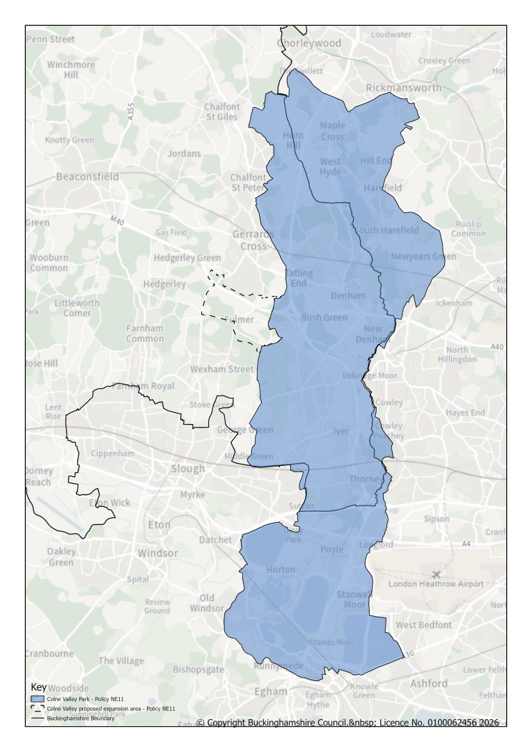
NE12 - Special Areas of Conservation, Special Protection Areas and Ramsar sites
Policy NE12: Special Areas of Conservation, Special Protection Areas and Ramsar sites
- Proposals are required to demonstrate no adverse effect on the integrity of Habitats sites (Aston Rowant Special Area of Conservation, Chilterns Beechwoods Special Area of Conservation, Burnham Beeches Special Area of Conservation, Windsor Forest and Park Special Area of Conservation or South West London Waterbodies Special Protection Area / Ramsar site), either alone or in combination with other plans or projects, in line with the Habitats Regulations.
- Development will be required to carry out a Habitats Regulations Assessment and apply the mitigation hierarchy.
- Where development is located within an identified Exclusion Zone in relation to a Special Area of Conservation, development which could lead to increased recreational pressure will not be permitted. As shown on the Policies Map, the Plan defines a five hundred metres exclusion zone for residential development around Burnham Beeches SAC and Chilterns Beechwoods SAC (Ashridge Commons and Woods SSSI only).
- Where development is located within an identified Zone of Influence in relation to a Special Area of Conservation, mitigation will be provided in the form of SANG/ Gateway and SAMM requirements, in line with the relevant Mitigation Strategy for that Special Area of Conservation or component part. As shown on the Policies Map, the Plan defines a Zone of Influence for Burnham Beeches SAC and Chilterns Beechwoods SAC (Ashridge Commons and Woods SSSI only).
- In this plan, project-level SANGs allocations are made as part of the following strategic sites:
- Aylesbury North of A41
- Aylesbury North NESS
- Aylesbury Land south A41
- Cheddington NESS
- Land at Horton, Cheddington
- RAF Halton
- Stoke Mandeville NESS
- Wing NESS
- The following sites, as shown on the Policies Map, are also allocated for strategic Suitable Alternative Natural Green Space:
- Kingsbrook Meadows, Aylesbury
- Land at Bell Lane, Chesham
- Spade Oak Lake, Little Marlow (see policy NE15 Little Marlow Lakes)
- The following site, as shown on the Policies Map, is allocated for a Gateway:
- Land at Wards Hurst, Ringshall (Gateway – see policy NE14)
7.218Habitat sites are the common name by which Special Areas of Conservation, Special Protected Areas and Ramsar sites are categorised. Candidate sites to these categories are also covered. Habitat sites have the highest level of environmental protection (see policy NE4).
7.219Based on the Habitats Regulations Assessment (HRA) of the plan, the Habitats sites needing consideration as part of the plan are:
- Chilterns Beechwoods SAC – regarding recreational pressure, urbanisation, air quality and impact on functionally-linked habitat for stag beetle
- Burnham Beeches SAC – regarding recreational pressure, urbanisation, water resources (water quality, quantity, level and flow) and air quality
- Aston Rowant SAC – regarding air quality
- Windsor Forest and Great Park SAC – regarding air quality and recreational pressure
- South-West London Waterbodies SPA/Ramsar site – regarding public access/ disturbance, loss of functionally linked land, water resources (quantity, level and flow) and water quality.
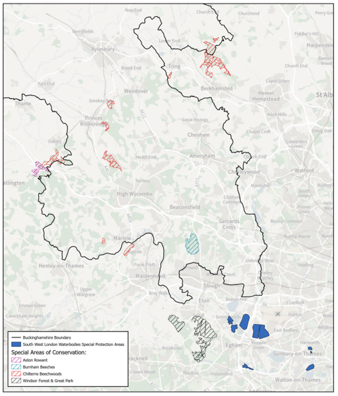
7.220Buckinghamshire is home to part of the Chilterns Beechwoods Special Area of Conservation (CBSAC), an extensive area that is designated and given the highest level of protection for its importance to nature. SACs often have a unique character and draw which can be difficult to replicate. The CBSAC is designated for its beech forests, semi-natural dry grasslands and scrub, and population of stag beetles, and forms part of the national site network[12].
7.221The Chilterns Beechwoods SAC is made up of nine separate sites that are partly located across Berkshire, Buckinghamshire, Hertfordshire and Oxfordshire.
- Ashridge Commons and Woods SSSI (partly in Dacorum Borough Council)
- Aston Rowant Woods SSSI (part in Oxfordshire)
- Bisham Woods SSSI (Royal Borough of Windsor and Maidenhead)
- Bradenham Woods, Park Wood and the Coppice SSSI
- Ellesborough and Kimble Warrens SSSI
- Naphill Common SSSI
- Pullingshill and Hollowhill Woods SSSI
- Tring Woodland SSSI (Dacorum BC)
- Windsor Hill SSSI
7.222Buckinghamshire is also home to the Burnham Beeches SAC in the southeast of the County and is neighbouring the Aston Rowant SAC west of Stokenchurch, and Windsor Forest and Great Park SAC south of Windsor. They also form part of the national sites network:
- The Burnham Beeches SAC is designated for its beech forests. It is an extensive area of former beech wood-pasture with many old pollards and associated beech and oak forests. Surveys have shown that it is one of the richest sites for deadwood invertebrates in the UK, including 14 Red Data Book species. It also retains nationally important epiphytic communities.
- Aston Rowant SAC is designated for its rare lowland juniper scrub on chalk. It is one of the best remaining examples in the UK.
- Windsor Forest and Great Park SAC are designated for its oak and beech. It has the largest number of veteran oaks Quercus spp. in Britain (and in Europe), a consequence of its management as wood-pasture. It is also designated for the rare violet click beetle (one of only three sites in England).
- The South-West London Waterbodies SPA/Ramsar site are also potentially impacted by in-combination effects of the plan. They are designated is designated due to its internationally important populations of wintering waterbirds, particularly Gadwall and Northern Shoveler. The site comprises a network of reservoirs and former gravel pits that provide critical habitat for these species, especially during the non-breeding season.
7.223The SACs and SPAs have conservation objectives that are in place to help their conservation and restoration, and to prevent the deterioration or significant disturbance of their qualifying[13] features. SACs also have Site Improvement Plans.
7.224We have a legal duty as the ‘competent authority’ under the Habitats Regulations to ensure the integrity of the Aston Rowant SAC, Burnham Beeches SAC and Chilterns Beechwoods SAC are not adversely affected by new planning proposals, either alone or in-combination with other plans or projects.
7.225In relation to Chilterns Beechwoods SAC, an assessment in 2022 showed Ashridge Commons and Woods SSSI under pressure from recreational visits, affecting its conservation objectives. Ashridge Commons and Woods SSSI, situated on the Hertfordshire/Buckinghamshire border, forms a significant part of the Chilterns Beechwoods SAC, and is part of the Ashridge Estate, managed by the National Trust.
7.226The Council's approach to protecting Ashridge Commons and Woods SSSI from adverse recreational impacts can be found in the Chilterns Beechwoods Special Area of Conservation Mitigation Strategy[14], which was prepared in partnership with Natural England, the National Trust and the affected adjoining local authorities, Dacorum Borough Council, Central Bedfordshire Council and St Albans City and District Council. The Council continues to work collaboratively with the partner authorities to coordinate implementation and delivery.
7.227The strategy sets out the types of development proposals that will be 'screened in' through the first stage of the Habitats Regulations Assessment and will require an Appropriate Assessment (stage 2). It also establishes an Exclusion Zone, a Zone of Influence, and mitigation measures that will be delivered through:
- Implementing a Strategic Access Management and Monitoring Strategy (SAMMS) at Ashridge Estate by the National Trust; and
- The provision of new or enhanced green space across the area comprising either Suitable Alternative Natural Greenspace that absorbs recreational pressure, or a Gateway site, (see policies NE13 and NE14) that deflects recreational pressure away from Ashridge Commons and Woods SSSI.
7.228The SAMMS measures are designed to directly manage, avoid, mitigate and monitor identified issues at Ashridge. The SAMMS tariff for each net new home built can be found on the Council's website.
7.229The SAMMS measures and related charge will be reviewed every 5 years, in line with the Mitigation Strategy Cooperation Agreement. The National Trust is also preparing a spatial plan to guide the future management of the Ashridge Estate.
7.230At Burnham Beeches, a similar issue relating to adverse recreational impacts requires mitigation in the form of alternative SANG and SAMM payments. Hydrological pathways are also a potential concern. The Council is working with partners and is developing a revised Mitigation Strategy for Burnham Beeches, to provide consistency across the former district areas. The policy defines an Exclusion Zone for residential development and refers to a Zone of Influence of 5.6km Within the ZOI, development that would result in adverse effect to the SAC is required to mitigate its impacts by providing SANG and SAMMs contributions. In time the mitigation strategy will replace the adopted Burnham Beeches SPD.
7.231Key evidence studies drawn upon in preparing the Plan's policy comprise:
- Submitted Dacorum Borough Council Local Plan, associated Habitats Regulations Assessment of the Dacorum Local Plan (October 2024) and examination supporting evidence.
- Habitats Regulations Assessment Appropriate Assessment for this local plan
- Buckinghamshire Chilterns Beechwoods Special Area of Conservation Mitigation Strategy.
- Visitor survey[15], recreation impact assessment and mitigation requirements for the Chilterns Beechwoods SAC and the Dacorum Local Plan, 2022.
- Burnham Beeches Supplementary Planning Document (2020).
- Visitor surveys Burnham Beeches
7.232The Local Plan for Buckinghamshire Habitats Regulations Assessment has concluded that avoidance and mitigation should be considered where increased recreational use is predicted to cause adverse impacts on a site (all Habitats sites apart from Aston Rowant SAC). Avoidance of recreational impacts at Habitat sites involves locating new residential development further away (where possible). Strategic plans, such as Local Plans provide the mechanism for this. Where avoidance of impacts is not possible, mitigation will usually involve a mix of access management, habitat management and provision of alternative recreational space. The HRA concluded that the plan would not result in adverse effects given the plan policy framework and subject to the mitigation strategies being implemented.
7.233The Plan allocates Suitable Alternative Natural Greenspaces (SANG) both as part of key strategic sites and as standalone strategic SANGs, as well as a Gateway site. The Plan also sets out SANG and Gateways principles for these – and others – to come forward within the lifetime of the Plan. In doing so, the Plan provides a strong strategic framework, to sufficiently mitigate any potential adverse effects on the designated sites, alone and in combination with other plans and projects. Project levels HRAs will still be required as part of the planning process.
7.234We will continue to monitor the SACs over the lifespan of the Plan and update the Chilterns Beechwoods SAC Mitigation Strategy and Burnham Beeches SAC Mitigation Strategy to reflect updated evidence. This may include adding mitigation measures for further impact pathways or component sites of the SAC.
7.235In relation to recreational impacts at other sites, the HRA concludes no adverse effects arising from the plan alone or in combination.
7.236In relation to the other potential impact pathways, the HRA of the Plan concludes that there are no adverse effects arising of the plan alone or in combination with respect to Functionally Linked Land and Air quality.
7.237The HRA also concludes that Policy IN2 ensures that there will be adequate wastewater treatment provision for all development that could potentially impact Southwest London Waterbodies SPA/Ramsar. Additionally, Policy NE1 Water quality requires development to not adversely affect the water quality of surface or underground water bodies. This existing legal requirement and policy framework ensures that there will not be an adverse effect of the LDFP on Burnham Beeches SAC with regards to this impact pathway.
7.238The Burnham Beeches Hydrology Study has defined a catchment area within which reductions in permeability may impact the water quantity and level within the SAC. There are no sites allocated for development within this hydrological catchment. Given this it is concluded that the LPFB will have no adverse effects on integrity of the Habitats site following appropriate analysis via this impact pathway.
NE13 - Suitable Alternative Natural Green Space
Policy NE13: Suitable Alternative Natural Green Space
1. Proposals for Suitable Alternative Natural Greenspace (SANG) will be supported where they meet all the following principles:
- Provide capacity to mitigate adverse effects of recreational pressure on a Special Area of Conservation at a minimum of eight hectares of SANG per 1,000 new occupants (or subsequent capacity advised by Natural England).
- Provide a minimum 2.3km circular walk on the SANG.
- Provide the experience of visiting the countryside by being free from unnatural intrusion (including, but not limited to, noise, odour and urban views).
- Provide suitable parking of at least one car parking space per hectare of SANG and appropriate cycle and wheeling parking provision.
- Be delivered prior to the occupation of the qualifying development(s) to which it relates.
- Be legally secured, fully funded, and managed for a minimum of 80 years by an enduring body agreed by the Council in consultation with Natural England.
- Be subject to a SANG Monitoring and Management Plan agreed by the Council in consultation with Natural England; and
2. Where proposals are within the Chilterns Beechwoods SAC zone of influence, SANGs should be in accordance with the Chilterns Beechwoods SAC Mitigation Strategy and any further bespoke criteria as agreed by the Council, in consultation with Natural England.
3. Where proposals are within the Burnham Beeches Zone of Influence, they should be in accordance with the Burnham Beeches SAC Mitigation strategy and any further bespoke criteria as agreed by the Council, in consultation with Natural England.
4. SANG must be located according to the scale of the proposed scheme seeking allocation as follows:
- Developments of ten or more net dwellings or equivalent, will provide either contributions to a Strategic SANG or a bespoke on-site or off-site SANG as part of the proposed development.
- Major developments of ten or more net dwellings or equivalent must be within the catchment of a specified SANG to be able to use its capacity.
- Minor developments of fewer than ten net dwellings or equivalent may rely on a Strategic SANG located anywhere within the Zone of Influence, or a Gateway site.
5. Development proposals that use a bespoke or third party owned SANG must demonstrate that:
- The SANG meets SANG criteria and is being managed by an enduring body.
- The SANG allocation has been agreed with the landowner.
- The SANG has sufficient capacity; and
- The SANG credits (where one credit equates to capacity for one dwelling or equivalent) have been secured by an appropriate legal agreement.
6. Proposals for a SANG or alteration to an existing SANG must consider how access for vulnerable groups has been provided.
7.239Suitable Alternative Natural Greenspace, or SANG, is the term given to greenspaces that are created, or enhanced, with the specific purpose of absorbing recreational pressure that would otherwise occur at National Sites, such as the Chilterns Beechwoods SAC at Ashridge Commons and Woods SSSI or Burnham Beeches SAC. The Plan's principles for SANG draw from features which have been found to attract visitors to the Ashridge Estate, suitability is based Natural England's SANG guidelines and best practice, which has been established at other SAC and Special Protection Areas (SPA) across England.
7.240The standards within the SANG principles are based on the Council's evidence and should be read in conjunction with the Chilterns Beechwoods SAC Mitigation Strategy[16] and the Burnham Beeches SAC Mitigation Strategy. The Mitigation Strategies also set the catchment area for SANG, which vary in size depending on their characteristics and location. SANG must be secured for at least 80 years from the occupation of the last dwelling for which it provides mitigation.
7.241The Council's allocation protocols within the Mitigation Strategies define how we will assess applications from development to use Council-owned Strategic SANG. The allocations protocols will be periodically updated to reflect the Council's priorities for enabling new homes and the available SANG supply. When Council owned SANG capacity will not be made available, developments will be expected to find their own SANG solution, which may include a bespoke SANG either on or off-site. We will consult with Natural England on proposals for new SANG, which must be in place for residents to use before new homes are occupied. The tariff per net new home for Strategic SANG is published on the Council's website.
7.242Further guidance is provided within the Chilterns Beechwoods SAC Mitigation Strategy and Burnham Beeches SAC Mitigation Strategy, on our website, and any further bespoke criteria as advised by the Council, in consultation with Natural England.
NE14 - Gateway sites
Policy NE14: Gateway sites
1. Gateway proposals will be supported where they relocate existing visitor facilities away from Special Areas of Conservation and demonstrate that they will reduce recreational pressure within the SAC.
2. Proposals that intensify or expand uses within, or are likely to increase visitor numbers to, the SAC will not be supported.
3. Gateway sites must meet the SANG principles, as stated in policy NE13, and all the additional following principles:
a. Be located adjacent to, and within a radius of, 500m of the boundary of the SAC.
b. Be greater than 8 ha in area, with preference being given to sites greater than 15 ha in area.
c. Be a destination venue, offering a variety of facilities that will maximise dwell time within the Gateway for a large proportion of visitors; and
d. Provide a range of facilities and amenities to draw visitors to the location, in preference to the SAC, to include as a minimum:
- Visitor facilities (including refreshments, toilets and local retail), information and wayfinding.
- iDesigned to meet the needs of families, dog walkers and accessibility for all requirements.
- Sufficient parking to meet expected demand (or subsequent requirements advised by Natural England); and
- Designed to reflect local heritage, environment and the character of the SAC.
4.The catchment area for a Gateway is the Zone of Influence of the corresponding Special Area of Conservation.
5.Development proposals that mitigate related recreational pressure impacts by using a Gateway will need to demonstrate that:
a. The Gateway is being managed by an enduring body.
b. The Gateway allocation has been agreed with the landowner.
c. The Gateway has sufficient capacity; and
d. The Gateway credits (where one credit equates to capacity for one dwelling or equivalent) have been secured by an appropriate legal agreement.
7.243A Gateway site is a new type of mitigation to protect national sites from recreational pressure, as supported by Natural England. In Buckinghamshire, this is currently progressed in relation to the Chilterns Beechwoods SAC element at Ashridge, through two sites: Land at Wards Hurst, Ringshall (in Buckinghamshire) and Land at Hill Farm (in Dacorum Borough). Within the lifetime of the plan, it could also be implemented, if necessary, in relation to other SACs such as Burnham Beeches.
7.244The purpose of a gateway is like that of SANG, to create an attractive alternative to the SAC that deflects visitors away from there, reducing recreational pressures as a result. The key differences are that a gateway is located adjacent to the SAC, drawing visitors away from its protected features to a new welcome hub that is outside of the designated area, and that it offers a greater range of community facilities in compared to a SANG such as a café and local shops for retail, food and beverage, to encourage visitors to remain within the gateway for a longer period of time. The catchment for a gateway is a much wider area than for SANG and is set at the Zone of Influence for the SAC component it relates to (such as Ashridge Commons and Woods SSSI).
7.245The National Trust is preparing gateway proposals as part of its Spatial Plan[17] for the Ashridge Estate, informed by ongoing discussions with Natural England, Buckinghamshire Council and Dacorum Borough Council and others. Their ambition is to fund the creation of the new Gateways through a combination of financial reserves, commercial loans and SANG contributions from new development. The catchment of these Gateways would be the entire Zone of Influence for the Ashridge component of the Chilterns Beechwoods SAC (currently 12.6km). Applications for Land at Ward’s Hurst Farm and Land at Hill Farm (in Dacorum) are anticipated to be submitted in summer/autumn 2026, subject to National Trust funding. Further guidance on the procedures for gateway mitigation will be provided on the Council's website.
NE15 - Little Marlow Lakes
Policy NE15: Little Marlow Lakes
1. As shown on the Policies Map, the Little Marlow Lakes area is allocated for
- Suitable Alternative Natural Greenspace at Spade Oak Lake and
- wider outdoor recreational uses
Spade Oak Lake SANG
2. Within the Little Marlow Lakes allocation, Spade Oak Lake is allocated as a strategic Suitable Alternative Natural Greenspace to mitigate adverse effects on the Burnham Beeches Special Area of Conservation from qualifying development within the defined Zone of Influence. Development that comes forward in the SANG will be consistent with the Little Marlow, Spade Oak Lake SANG Management Plan (December 2024 as amended). The SANG should be fully open and accessible, with all capital works completed, prior to any occupation of housing allocated to it.
3. Development should not preclude future proposals for enhanced visitor experience at the area, such as a café and toilet facilities.
4. Measures should be taken to reduce odour and water pollution and contribute to the long-term management of the area.
5. Parking facilities should be provided on and adjacent the restored Gravel Yard accessed from Muschallick Road.
6. All qualifying development will be expected to make financial contributions towards the SANG where it is seeking to rely on the SANG for mitigation, unless it can be demonstrated that the development would not result in any adverse impact on the SAC either alone or in combination with other development.
7. Any residential development relying on this SANG as mitigation will be required to provide safe, convenient and direct access to Marlow and Bourne End for pedestrians, cyclists, and disabled and other users of this area to help connect Marlow to Bourne End.
Little Marlow Lakes
8. Development within the Little Marlow Lakes area should not have an adverse effect upon the amenities or setting of the River Thames, watercourses, flood risk, lakes, wet woodlands, adjoining conservation areas, or listed buildings, or which prejudices the function of the area for which it is allocated.
9. Any development will be required to provide safe, convenient and direct access to Marlow and Bourne End where possible for pedestrians, cyclists, wheeling and other users, to help connect Marlow to Bourne End.
10. Any development close to an existing waterbody or other wetland feature should protect and enhance that feature’s ecological value, biodiversity, hydrology, water quality, and its natural setting within the area.
7.246The Little Marlow Lakes area occupies an area of 329 ha between the A4155 Bourne End and Wooburn to Marlow Road and the River Thames and between the A404 and Coldmoorholme Lane. The area is in the Green Belt, and adjacent to the Chilterns National Landscape and the River Thames. The proposed strategic SANG at Spade Oak Lake forms only a small part of the 329 hectares.
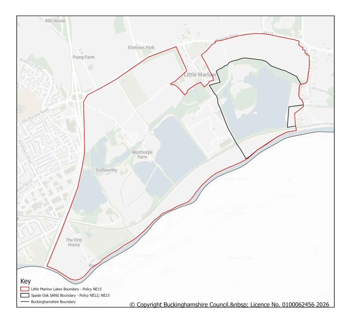
7.247The area includes several former gravel pits (restored as lakes, meadows or arable land) and several areas of woodland, including ecologically valuable wet woodland habitat. There is athletics track with part of a cycleway and a water sports site. In late 2025, planning permission was granted on appeal in the northwestern part of the site for a major development of Marlow Film Studios, around 170,000sqm over twenty-three hectares. The Little Marlow Lakes Area policy does not cover the built-up area of Little Marlow village.
7.248It has the main purpose of providing and improving opportunities for the enjoyment of the countryside by the public. The area is used for a variety of formal and informal recreational and sporting uses and is crossed by several public footpaths including an extensive network of circular routes of varying length with increasing use by the public, including disabled users. The wider lakes area is used for fishing, water sports, open-water swimming, camping and outdoor exploration activities.
7.249Part of Little Marlow Lakes, known as the Spade Oak Lake area, presents an opportunity to deliver an alternative destination to Burnham Beeches in the south-east of Buckinghamshire, in the form of a strategic Suitable Alternative Natural Greenspace (SANG). Burnham Beeches is a Special Area of Conservation, and a large part of the SAC is also designated as a National Nature Reserve, open to the public. This presents a need to balance a role for biodiversity, and its role in providing for outdoor recreation and public enjoyment of nature. Providing a SANG destination with improvements at Spade Oak Lake area provides an opportunity to offset visitor pressures on Burnham Beeches (see policies NE12 and NE13) within the SANG catchment. The Council is in process of designating a Country Park on the Spade Oak Lake SANG area and intends this to be known as ‘Little Marlow Lakes Country Park’ defined by the Countryside Act 1968. This means the area can provide or improve opportunities for the enjoyment of the countryside by the public.
7.250On the Spade Oak Lake SANG area, the mitigation management plan provides for publicly accessible open space, ecological and biodiversity enhancements. In March 2026, the council made a resolution to grant planning permission for the SANG subject to completion of an updated Mitigation and Management Plan and a signed Memorandum of Understanding. On this site there are opportunities in the future for further enhancements that may take place to support the enjoyment of the SANG and new country park. These can include a cafe and associated facilities, public toilets, a play area, additional parking and storage facilities. These facilities must be consistent with the Green Belt and SANG and have no adverse harmful effect on the ecological value of the site.
7.251The Little Marlow Lakes area lies within the Green Belt. Development opportunities must preserve the openness of the Green Belt.
7.252There are also important nature conservation interests in the area, and it contains an extensive area of open water. The former gravel pits, now waterbodies, are important in biodiversity terms, particularly for wintering and breeding birds. The Buckinghamshire and Milton Keynes Local Nature Recovery Strategy is recognising most of the Little Marlow Lakes area as an Area that Could Become Important for biodiversity. This must be considered in all development proposals to deliver a biodiversity net gain.
7.253The potential may exist for additional comprehensively planned outdoor recreation and tourism uses as the area develops. There may be scope for such development on the western side of the site, to the west of the Crowne Plaza hotel.
7.254The site contains critical drainage areas; as a result any flood risks presented by surface water and groundwater flooding should be assessed and mitigated for in accordance with Policy development should reflect the open nature of the site and the long distance views of and over the site from the National Landscape, from Winter Hill, and vantage points from footpaths across the river. Development should not propose the raising of land within the Flood Zones, including the floodplain of Main Rivers. Where this is unavoidable and necessary, appropriate compensatory measures will be required, in consultation with the Environment Agency.
7.256Care should be taken to give space for ‘spring points’ of groundwater or ‘natural springs’, where there has been historical records or evidence of them in the area. Recreational spaces developed for sporting purposes should also consider the impact on infiltration of rainwater into the ground. The low-lying areas are susceptible to groundwater emergence.
7.257Development must also respect and enhance the setting and amenities of both the Little Marlow Conservation Area, which is washed over by the site, and the Abbotsbrook Conservation Area, which lies to the east. Development must also have regard to the listed buildings in those Areas; their settings and other buildings of interest identified in the Conservation Area documents. The setting and amenities of the River Thames must also be preserved and policies for the landscape and river protection will apply. Areas of existing or potential wildlife habitat should be maintained and enhanced.
7.258Development proposals must also have regard to the ground conditions and land stability due to mineral extraction and landfill activities in the area. Proposals for development may need to be accompanied by reports to show the suitability of the land for the purpose intended and to assess and/or manage the presence of migrating landfill gas or other sources of pollution.
7.259Development should also provide the opportunity to create new means of access to the site for walkers, cyclists, and disabled users, and links to the wider highway network.
7.260Development is required to enable the creation of pedestrian and cycle access on the east side of the area to secure easy access to residents of Bourne End. This could take the pressure off the Thames Path which has significant visitor pressure at times of the year. Any active travel scheme in proximity to Spade Oak needs to take account of the Little Marlow-Spade Oak Lake SANG Management Plan.
7.261Further infrastructure improvements to the area include the wider delivery of green infrastructure in this part of Buckinghamshire and include flood risk management measures (e.g. Natural Flood Management projects). Transport infrastructure could also include walking, wheeling and cycling opportunities through the delivery of inter-settlement corridor improvements between Marlow and Bourne End.
7.262Car parking facilities are to be provided at the restored Spade Oak Lake Gravel Yard, accessed from the A4155 and Muschallick Road in accordance with the Little Marlow Spade Oak Lake SANG Management Plan 2024. This will encourage visitors to the site from Wooburn, Bourne End, and the wider area. There is some limited parking at the running track to the west. Development should also consider the opportunity for a new rail halt which could improve overall accessibility both for the formal and informal recreational potential of the area.
NE16 - Protection of the Green Belt
Policy NE16: Protection of the Green Belt
1. Development in the Green Belt is inappropriate except where it is on previously developed land that meets the criteria below or meets one of the following exceptions:
a) Buildings for agriculture and forestry.
b) The provision of appropriate facilities (in connection with the existing use of land or a change of use) including buildings for outdoor sport, outdoor recreation, recreational moorings and water-based recreation activities, cemeteries and burial grounds and allotments; as long as the facilities preserve the openness of the Green Belt and do not conflict with the purposes of including land within it;
c) The replacement or extension of buildings.
d) Limited infilling only within the built-up villages identified on the Policies Map and in accordance with the definition in paragraph 7.4.173 below.
e) Limited affordable housing for local community needs only in accordance with Policy HO9 Rural Exception Sites.
f) Other forms of development specified in the NPPF provided they preserve its openness and do not conflict with the purposes of including land within the Green Belt.
2. Inappropriate development will not be supported unless there are very special circumstances. Very special circumstances will exist when the harm to the Green Belt by reason of inappropriateness, and any other harm, is clearly outweighed by other considerations.
7.263Whilst Green Belt is not an environmental designation, it still protects areas from development, preventing sprawl and keeping areas open. As part of this plan, the Green Belt has been reviewed to identify Grey Belt and Provisional Grey Belt land (Grey Belt land is land that has previously been developed or does not strongly meet Green Belt purposes). This policy applies to all Greenbelt land regardless of its Grey Belt designation.
7.264Whilst in many instances national policy provides sufficient detail to determine whether a proposal is appropriate development in the Green Belt, there are instances which require clarification in the interests of certainty and consistency. In addition, they are necessary to guard against a cumulative impact that residential outbuildings can have on the openness of the Green Belt. These are set out in the Policies NE17 and NE18 and include, for example, our benchmark approach to determining the degree to which a dwelling can be extended without resulting in disproportionate additions. Hence the inclusion of 3(a-c) in Policy NE18 below. Note, a Neighbourhood Plan still must accord with the strategic policies of the Local Plan.
7.265The villages that we have identified as appropriate for limited infilling are those villages which are washed over by the Green Belt, but which are identified in the Settlement Hierarchy as sustainable locations for incremental growth. The villages are Tiers 4 and 5 in the Settlement Hierarchy.
7.266Limited infilling must have regard to the settlement pattern and the grain and morphology of the village. It does not need to be frontage development; it can be a backland plot. ‘Backland’ normally refers to the development of land that sits behind an established building line of existing housing or other development and is often land that is used as a garden. Whereas ‘Infill’ is a small gap within an otherwise built-up street frontage.
7.267To be limited infilling (whether in a frontage or backland), the plot must be comparable in size and shape to the average house plots in the village (excluding any that are atypically large or small). The proposed building must be similarly comparable in size and scale (again, excluding outliers). This is assessed on the size of the building proposed (not the size of each dwelling) to allow flexibility for smaller pairs of semi-detached houses as infilling in areas of larger detached housing (or vice versa).
7.268Suitable infilling plots can be created by the subdivision of larger residential gardens (or other previously developed land) but not by the artificial sub-division of agricultural fields, or paddocks, or similar land that has not been previously developed, where this is likely to result in incrementalism.
7.269It is important to support expansion and improvement of the rural economy within the Green Belt and for that our Rural Diversification policy covers the different aspects that can affect it.
NE17 - Extension or replacement of buildings and residential outbuildings in the Green Belt
Policy NE17: Extension or replacement of buildings and residential outbuildings in the Green Belt
1. The extension or replacement of a building will only be considered appropriate development in the Green Belt when it satisfies conditions (a) to (c) below. The gross external floor area of existing outbuildings unless proposed to be demolished will not be included in any calculations.
- The total gross external floor area of the resulting building is no more than 50% greater than the original building gross external floor area; and
- has no adverse impact on openness by virtue of bulk, height and location; and
- It accords with a made Neighbourhood Plan (where applicable)
2. Extension or replacement of a dwelling by more than 50% of the original building gross external floor area is disproportionate, is likely to harm the openness of the Green Belt and would not be supported.
3. The erection of domestic outbuildings will be considered not inappropriate development in the Green Belt within village built-up areas shown on the Policies Map. Elsewhere in the Green Belt, any increase in the gross external floor area of residential outbuildings will only be considered appropriate development when all the following conditions apply:
- The total gross external floor area of all outbuildings on the property would not exceed 25% of the gross external floor area of the original dwelling.
- No more than 50% of the total area of the curtilage (excluding the ground area of the dwelling) shall be occupied by outbuildings.
- No part of the development would exceed 4 metres in height (measured from the highest part of the surface next to the building where that has not been raised).
4. Proposals for the extension or replacement of a dwelling or the erection of an outbuilding will also be required to respect the open character of the Green Belt and appear proportionate to the original dwelling, taking account of visual impact.
7.270For the avoidance of doubt, in applying (1) and (2) in the policy, the extension of an original building to increase floorspace shall include floorspace created in the roof.
7.271The clarification in 3 (b and c) in the policy is necessary to ensure the openness of the Green Belt is not harmed by development which might share the outward form and design of agricultural buildings, but which are not reasonably necessary for agriculture (or forestry).
7.272For the purposes of the policy, the term’ original building’ means a building as it existed on 1 July 1948 or, if constructed after 1 July 1948, as it was built originally.
7.273For the purposes of Green Belt policy, a residential outbuilding will be classed as an extension providing it after development is located within 5m of the main dwellinghouse on the site. The erection of any residential outbuildings more than 5m from the main dwelling is unlikely to be classed as an ‘extension’.
NE18 - Development in the countryside outside the Green Belt
Policy NE18: Development in the countryside outside the Green Belt
Within that portion of the countryside outside of the Green Belt, and subject to other relevant policies, developments will only be supported where it is for at least one of the following:
- Development that accords with a made Neighbourhood Plan.
- Development for agriculture and forestry, outdoor sports and recreation, and for cemeteries where there is an evidenced need.
- Additional buildings where these are required to support an existing rural enterprise or business located in the countryside, which are proportionate to the existing.
- The construction of additional buildings only within settlement built up areas. These also apply to any made neighbourhood plan settlement boundaries.
- Rural Exceptions Site housing.
- Sites for Gypsy, Traveller or Travelling Showpeople.
- Housing for rural workers.
- Extensions, outbuildings and alterations to existing dwellings.
- The conversion of existing buildings.
- The redevelopment of previously developed land, providing these respects the rural character of the surroundings and is of similar impact to the existing building or structure.
- Improvements/enhancements to support the Grand Union canal network, including moorings and water-based activities.
7.274This policy implements the remaining aspects of the Housing Spatial Strategy. It applies to those areas of the countryside that are not in the Green Belt and are not otherwise allocated for development in this Plan. It reflects the general principles of other Policies in this Chapter which ensure that new development is located where it can contribute to sustainable development. It also supports the NPPF aim to avoid isolated new dwellings in the countryside.
7.275This policy and the Housing Spatial Strategy also recognise that there will be some small housing sites that come forward that have not been allocated in this or other plan documents; these are known as windfall sites. The NPPF defines windfall sites as those that have not been specifically identified as available in the Development Plan. Not all locations, however, will be suitable or sustainable. This policy aims to make it clear that existing settlements are the most sustainable locations for new developments. Alongside this however the Council wishes to support the reuse of existing buildings. Many such proposals will be deemed Permitted Development, but only outside of the Chilterns National Landscape. This policy sets the criteria for considering in principle whether development in the countryside beyond the Green Belt is acceptable.
7.276This policy aims to support rural enterprises and businesses located in the countryside, recognising the rural diversification they can provide (See Policy EC10). The policy recognises that any new development can have a positive impact on the local economy without any further significant impact on the countryside. This will ensure that the existing character is maintained whilst managing development appropriately in the countryside.
NE19 - National Landscapes and their setting
Policy NE19: National Landscapes and their setting
- The Chilterns National Landscape is a nationally designated landscape with the highest status of protection for conserving and enhancing landscape. Scenic beauty and wildlife and cultural heritage are also important.
- Within the National Landscape the scale and extent of development should be limited whilst in the setting, development should be sensitively located and designed.
- Proposals for all development within and in the setting of the Chilterns National Landscape must demonstrate how they address all the following:
- take a landscape-led approach to development.
- conserve and enhance the Chiltern National Landscape’s special qualities in accordance with national planning policy, the purposes of its designation and local landscape character assessments.
- meet the aims of the Chilterns National Landscape Management Plan, making practical and financial contributions as appropriate.
- respond to the Chilterns Building Design Guide, Technical Notes and Position Statements, including that on the setting of the Chilterns National Landscape.
- avoid adverse impacts from individual development proposals and any cumulative effects, unless these can be satisfactorily mitigated and
- are appropriate to the economic, social, health and environmental wellbeing of the area.
Major Development
- Major developments will be refused unless exceptional circumstances can be demonstrated as defined by national planning policy and where it is demonstrated to be in the public interest. Consideration of such applications should include an assessment of al the following:
- the need for the development, including in terms of any national considerations, and the impact of permitting it, or refusing it, upon the local economy.
- the cost of, and scope for, developing outside the designated area, or meeting the need for it in some other way.
- any detrimental effect on the environment, health, the landscape and recreational opportunities, and the extent to which that could be moderated.
- Proposals for major development will need to be accompanied by a Landscape and Visual Impact Assessment (LVIA) produced in accordance with current guidance from the Landscape Institute. At the Council’s request, where the landscape visual impact is expected to be moderate or higher, non-major development may also require a LVIA or landscape appraisal. The scope of any LVIA or landscape appraisal, including methodology, study area and representative viewpoints, should be agreed with the Council prior to its preparation and submission with a planning application.
Chilterns National Landscape
7.277The primary legislation for National Landscapes is the Countryside and Rights of Way Act 2000 (CROW Act). National Landscapes incorporate areas of the highest scenic quality, and, in landscape terms, are intended to enjoy equal status with National Parks. The primary purpose of National Landscape designation is the conservation and enhancement of the landscape and scenic beauty, which is also supported by the National Planning Policy Framework.
7.278The Chilterns National Landscape was designated in 1965 and extended in 1990, covering 27% of the Buckinghamshire Council area. It is managed by the Chilterns Conservation Board, who is responsible for reviewing and implementing the Chilterns National Landscape Management Plan. The Board also publishes the Chilterns Building Design Guide along with a series of Technical Notes and Position Statements, including that relating to the setting of the Chilterns National Landscape. These documents are a material consideration in planning decisions.
7.279The Chilterns National Landscape covers nine local authorities, who work together to safeguard the future of this valued landscape in conjunction with the Chilterns Conservation Board. It is a living landscape that supports homes, economic activities and leisure uses that complement and contribute to its distinctive character and natural beauty.
7.280The setting of the Chilterns National Landscape has no defined geographical boundary, but is the area within which developments, by virtue of their nature, size, scale, siting, materials or design have scope to impact upon the natural beauty and special qualities of the Chilterns. The council will support development in the setting of the National Landscape that is sensitively located and designed to avoid or minimise adverse impacts on the designated area.
7.281All development in the National Landscape or its setting should demonstrate a landscape-led approach to site selection and development design. A landscape-led approach begins with an appraisal of the site's contribution to the character and cohesiveness of the wider landscape, including relevant Landscape Character Area(s) and designations such as the Chilterns National Landscape. Public views to, from and across the site should also be assessed. Subsequent development proposals should then retain, enhance and supplement valuable landscape features, connections and views/vistas, responding with sensitive high-quality design that reinforces or complements established landscape character and visual amenity. Development proposals should demonstrate how any adverse impacts on landscape character or visual amenity have been avoided, minimised or mitigated.
7.282Where required, assessment of likely landscape and visual effects of development should be carried out in accordance with the 'Guidelines for Landscape and Visual Impact Assessment' ("GLVIA"), currently in its third edition, published by the Landscape Institute (LI) and Institute of Environmental Management and Assessment (IEMA). This document is supported by a series of Technical Guidance Notes (TGNs) also published by the Landscape Institute, which should also be addressed where relevant.
7.283The term “major development” for this policy does not refer to the familiar planning application thresholds (10 dwellings) or any other numerical threshold but instead requires the Council to judge the significance of a proposal in its specific context.
NE20 - Landscape character and visual amenity
Policy NE20: Landscape character and visual amenity
- Development must protect and enhance Buckinghamshire’s landscapes with an appropriate response to the site and its surrounding landscape. All development must meet all the following:
- the planning approach to land use, layout and design makes a positive contribution to the site landscape and its surroundings.
- draw upon Buckinghamshire’ Landscape Character Assessments for context and inspiration.
- reflect the positive aspects of existing local development patterns, including location, scale, form and detail.
- reinforce or enhance local character and distinctiveness in the built and natural environment.
- incorporate development within a robust landscape framework that contributes to local green infrastructure.
- avoid the loss of, or harm to key local views that encompass the site.
- avoid and minimise adverse impacts on local visual amenity generally.
- avoid and minimise the effects of lighting on the landscape at night, especially in those areas which are intrinsically dark, and avoid light pollution to the night sky.
- avoid noise pollution in areas relatively undisturbed by noise, especially those areas of recreational or amenity value.
- enhance public rights of way and provide other opportunities for walking.
- The first stage in mitigating impact is to avoid any identified significant adverse impact. Where it is accepted there will be harm to the landscape character, specific on-site and/or off-site mitigation will be required to minimise that harm and, as a last resort, compensation may be required as part of a planning application. This reflects the mitigation hierarchy set out in the National Planning Policy Framework. Applicants must consider the enhancement opportunities identified in the LCAs and how they apply to a specific site.
- In addition to measures above, for any development in the National Landscape or its setting please see policy NE18.
7.284All the landscape in Buckinghamshire is considered to have character and particular distinctive features to be conserved, positive characteristics to be enhanced and detracting features to be mitigated or removed. The Landscape Character Assessments (LCAs) are the primary evidence base which divides the entire landscape (beyond towns and the Chilterns National Landscape) into landscape character areas and landscape character types. There are four Landscape Character Assessments and an addendum which cover Buckinghamshire.
- Aylesbury Vale Landscape Character Assessment (May 2008, minor amendments May 2013)
- Chiltern Landscape Character Assessment (October 2011)
- South Bucks Landscape Character Assessment (October 2011)
- Wycombe Landscape Character Assessment (October 2011)
- Landscape Character Assessment Addendum (due summer 2026)
7.284A review of the above Landscape Character Assessments was undertaken between 2024 and is due for completion in summer 2026. This is an addendum to the existing LCAs and should be considered as part of the evidence base. The 2026 addendum study sets out landscape conservation guidelines for each landscape character area and considers the impact on each character area of major developments including the current construction of HS2. Therefore, all the landscape in Buckinghamshire can have innate ‘value’ as referred to in the National Policy Planning Framework (NPPF) (2024).
NE21 - Pollution, air quality and contaminated land
Policy NE21: Pollution, air quality and contaminated land
Noise Pollution
Significant noise-generating development will be required to minimise the impact of noise on the occupiers of proposed buildings, neighbouring properties and the surrounding environment.
Applicants may be required to submit a noise impact study or to assess the effect of an existing noise source upon the proposed development, prior to the determination of a planning application.
Developments likely to generate more significant levels of noise will be supported only where appropriate noise attenuation measures are incorporated which would reduce the impact on the surrounding land uses, existing or proposed and sensitive human and animal receptors, to acceptable levels in accordance with Government guidance.
Where necessary, planning conditions will be imposed and / or a planning obligation sought to specify and secure acceptable noise limits, hours of operation and attenuation measures.
Noise-sensitive development, such as residential, schools and hospitals, will not be supported if its users would be affected adversely by noise from existing uses (or programmed development) that generate significant unmitigated levels of noise.
Air quality
Any new developments that may have an adverse impact on air quality will be required to prove through a submitted air quality impact assessment that:
- The effect of the proposal would not exceed the National Air Quality Strategy Standards (or such other standards that supersedes or replaces them) or
- The surrounding area would not be materially affected by existing and continuous poor air quality.
Potentially polluting developments will be required to assess their air quality impact with detailed air dispersion modelling and appropriate monitoring. Air quality impact assessments are also required for development proposals that would generate an increase in air pollution and are likely to have a significantly adverse impact on biodiversity.
All development proposals which may cause significant impact on air quality directly or indirectly within Air Quality Management Areas will need to submit an air quality impact assessment to the planning authority. This needs to demonstrate how the proposal would impact on local air quality, whether the proposed use is appropriate, and how it would avoid, reduce and mitigate local pollutant emissions.
Where appropriate, planning conditions and/or Section 106 agreements will be imposed (or required) to minimise harmful air quality impacts arising from development.
Air Pollution and Protected Sites
Proposals emitting air pollutants which impact Habitats Sites must rule out adverse effects on the integrity of such sites. Where this is not possible the derogations route of the Habitats Regulations should be followed.
To avoid and minimise air pollution impacts any development requiring Habitats Regulations Assessment or Environmental Impact Assessment (EIA) should consider:
• the measures included which will minimise air pollution impacts on SSSIs and Habitats Sites and SSSIs during the design process of the development; and
• how air quality improvements have informed the design choices made about the location of the development, its layout, and distribution of buildings, on-site activities, amenity spaces and infrastructure.
Contaminated land
Development on or near land that is or may be affected by contamination will only be permitted where:
- an appropriate contaminated Land Assessment has been carried out as part of the application to identify any risks to human health, the natural environment, water quality or food production.
- where contamination is found which would pose an unacceptable risk to people’s health, the natural environment or water quality, the council will impose a condition, if appropriate, to ensure the applicant undertakes a desktop study, and if required, an intrusive site investigation, remedial measures and a validation report to ensure that the site is suitable for the proposed use and that the development can safely proceed.
Remediation works will usually be carried out prior to first occupation or use of any part of the development. Required remediation methods will be secured through a planning condition.
Pollution
7.245The council will ensure that no development creates or triggers unacceptable levels of pollution and land instability that could impact on human health, property and the wider environment, including environmental designations. Consideration must be given to adopting environmental best practice measures in all cases.
Noise Pollution
7.246Similarly, the effects of noise on amenity can be limited by separating noise-sensitive development such as homes, schools and hospitals from major noise sources. In cases where separation is not possible, the impact of noisy development and vibration on ambient noise levels should be assessed, for example by an environmental assessment, using the best available techniques and relevant technology and design guidance. This assessment will be relative to the scale of development being considered. Inconvenience can also be caused to residents by late night opening, odours from cooking bars, restaurants and similar facilities.
7.247It is important to stress that in addition to development proposals potentially having pollution impacts that require mitigation, applicants need to consider the impact of existing sources of pollution on proposed development (for example, proposals for residential development adjacent to railway lines, and associated noise and vibration impacts). As such, necessary supporting survey information will be required as appropriate.
Air quality
7.248Improved air quality through reducing air pollution in Buckinghamshire can bring considerable health benefits. The council's latest annual status report from 2025 has identified that road traffic is the main source of air pollution in Buckinghamshire with poor air quality increasing the risk of cardiovascular and respiratory disease and being a cause of premature death. The pollutants of greatest concern in Buckinghamshire are nitrogen dioxide and particulate matter.
7.249Any air quality assessment shall be undertaken in accordance with the Institute of Air Quality Management (IAQM) and Environmental Protection UK (EPUK now called Environment Policy Implementation Community (EPIC)) Land-Use Planning and Development Control: Planning for Air Quality guidance (or as replaced) and the Institute of Air Quality Management (IAQM) 2024 Guidance on the assessment of dust from demolition and construction v2.2 (or as replaced).
7.250Nitrogen oxides from both industrial and vehicle emission can have a significantly detrimental effect on wildlife habitat. Therefore, any large development needs to be carefully assessed through monitoring and air quality impact assessments prior to planning application determination.
7.251For the purposes of this policy section ‘Air Pollution and Protected Sites’, habitats sites are:
- special protection areas (SPAs) and potential SPAs
- special areas of conservation (SACs) and possible SACs
- Wetlands of International Importance (Ramsar sites)
- sites providing compensatory measures for adverse effects on habitats sites.
Contaminated land
7.252The presence of contamination may affect or restrict the use of land, but equally development may address the issue for the benefit of the wider community and bring the land back into beneficial use. In determining whether land contamination is an issue when assessing a planning application, the council will consider a range of information sources including its database of past industrial and commercial land uses, information provided by developers and third parties, statutory guidance, historic maps, and the council’s contaminated land strategy.
7.253The council expects a preliminary risk assessment, a site investigation and remediation strategy and verification plan to be required by a pre-commencement condition. In addition to remedial work being completed prior to occupation we will also require a validation report to be submitted prior to first occupation. Furthermore, the council requires the reporting of any unexpected contamination encountered during development.
7.254In April 2000, Part IIA of the Environmental Protection Act (EPA) 1990 came into force, introducing a new regime for the regulation of contaminated land in England. The main purpose of Part IIA is to provide a system for the identification of land that is posing unacceptable risks to health or the environment, and for securing remediation where unacceptable risks cannot be controlled by other means.
7.255Although most developments are rural in nature, there is development built on previously developed land, some of which may formerly have been employment land of an industrial or commercial nature and may therefore be affected by contamination and require further investigation. The term ‘contaminated land’ describes land polluted by, for example heavy metals and hydrocarbons, all of which may harm soils, fauna, flora, water resources and construction components.
7.256Redeveloping such land provides an opportunity to remediate the site of any contamination, so that any risk to human health, the environment and the structure itself is removed. The assessment and remediation of contaminated land is complex, with each site being judged individually to make it fit for end use. When carrying out an assessment, interested parties should use guidance set out in the council’s Technical Guide for Planning Applicants and Developers. This document provides a guide for developers on how to deal with land contamination and what information should accompany a planning application for the development of affected sites. It should also be read in conjunction with the Environment Agency’s Land Contamination Risk Management (LCRM) and the National Planning Policy Framework (NPPF) (2024).
7.257It is essential that a contaminated land assessment is carried out by a competent person and in accordance with the Environment Agency’s Land Contamination Risk Management (LCRM) and BS10175 (2011) and A2:2017 Code of Practice for the Investigation of Potentially Contaminated Sites. There are also other relevant guidance documents that should be referred to in relation to specific types of contamination for example ground gas risk assessments. Where there is evidence of contamination, remedial measures will need to be specified to ensure the development will not pose a risk to human health, and where appropriate, improve the wider environment.
7.258Consideration should also be given to the protection of groundwater from areas of contamination, where source protection zones (SPZs) are present. Reference should be made to the Environment Agency’s Groundwater Protection: Principles and Practice (GP3) document (or such other standards that supersedes or replaces them).
NE22 - Mitigating light impacts
Policy NE22: Mitigating light impacts
- In developments where external lighting is required, all of the following criteria must be met:
- The lighting scheme proposed is the minimum required for the security and safety of working activities.
- Light spill and potential glare and the impact on the night sky is minimised through the control of light direction and levels, particularly in residential and commercial areas, areas of wildlife interest or the visual character of historic buildings and rural landscape character (including the National Landscape where there may be significant impact)
- The choice and positioning of the light fittings, columns and cables minimise their daytime appearance and impact on the streetscape, and
- Where possible, in considering development involving potentially adverse lighting impacts to wildlife, the council will require surveys to identify wildlife corridors and ensure that these corridors are protected and enhanced. considering the impact of lighting, especially if they are found to support species known to avoid light.
- Artificial Light at Night (ALAN) can have negative impacts upon wildlife, most notably bats. Dark corridors should be protected as they are essential for the movement through the landscape which facilitates feeding, breeding and migrating of some protected species.
- The Council will only support proposals for ALAN in the National Landscape where it has been demonstrated the lighting, including any mitigation, will not detract from the purposes of the National Landscape.
- A mitigation hierarchy set out below should be followed to ensure the use of lighting is appropriate to the level of impact.
- Development affecting watercourses, ecological corridors and major developments must ensure that an informed assessment of potential Artificial Light at Night (ALAN) impact on wildlife is made and that ALAN is kept to the minimum level required to ensure health and safety. Where areas are identified as important to be kept dark for wildlife, lighting must be avoided.
- Avoidance - methods might include situating development that requires lighting, away from the sensitive dark area.
- Minimising - methods might include changing the lighting design strategy to reducing the impact (e.g. reducing lux levels, the Kelvin light temperature, or installing baffles or screens, or other interventions). Use best practice techniques for reducing or removing lighting where ALAN could adversely impact on ecological networks.
- Compensation - might include creating an alternative dark corridor which serves the same function.
- In all instances ALAN should have a clear purpose, be directed to only where it is needed, be no brighter than necessary and be turned off when not needed. ALAN should use warmer colour lights where possible.
- The ‘Bats and Artificial Lighting at Night, ILP Guidance Note 2023’ (or successor) provides best practice guidance which informs how lighting should be considered in development.
7.259The Buckinghamshire and Milton Keynes Local Nature Recovery Strategy https://bucksmknep.co.uk/nature-strategy/overview/ notes the importance of dark skies to reduce light pollution.
7.260There is a need to create dark sky areas and reduce light pollution for wildlife, so that animals and plants perceive day and night correctly. Light pollution has an overall negative impact on wildlife because it disturbs the way animals and plants perceive daytime and nighttime which upsets their natural systems and behaviour including navigate on and feeding habits. All light should have a clear purpose, be directed to only where it is needed, be no brighter than necessary and be turned off when not needed. Use warmer colour lights should be used where possible.
7.261Measure 99 of the LRNS is linked to the importance of dark corridors.
7.262At least two thirds of all animal species are active at night and require appropriate conditions to thrive, this includes inverts such as glow worms, mammals such as badgers and bats, fish including salmon and birds such as owls.
7.263Artificial Light at Night (commonly referred to by the acronym ALAN) is rapidly increasing, distribution nocturnal wildlife behaviour, migration and reproduction and having impacts on ecosystems.
7.264Examples of Dark Corridors include watercourse corridors, interconnected woodland and hedgerow networks.
7.265ALAN can detract from the character and openness of the Green Belt through light spillage, light glare and sky glow. These effects can be reduced or removed by using a lower strength light source and a cover which surrounds light to focus light onto a specific area.
7.266Two thirds of invertebrates are partially or wholly nocturnal and even diurnal species can be impacted by light. The charity Buglife report that light pollution is reducing nocturnal pollinator visits to flowers by 62% in some areas. Caterpillar populations declined by 52% in areas with streetlights. Glow-worm populations are reduced in artificially lit areas and their ability to communicate by ‘glowing’ is reduced. Dung beetles navigate using the moon and stars. Under light-polluted skies, they become disoriented and unable to find their way.
7.267Birds are also vulnerable to artificial light, causing them to fly toward lit areas. Research shows more birds migrating over urban compared to rural areas, this deviation could have a significant impact on energy levels and lead them to stop in suboptimal habitats.
7.268Artificial lighting can cause many problems for bats, including disrupting their roosting and feeding behaviour and their movement through the landscape; in the worst cases, causing direct harm. As all bats in the UK feed on insects the loss of food sources is also a considerable threat.
7.269The Chilterns National Landscape is considered an E1 Natural Zone within the E1 environmental zones defined by the Institution on Lighting Professionals (ILP) where particular care is needed. The Chilterns Conservation Board Lighting Planning Guidance (2025 or as amended) should be used to consider, mitigate and design solutions to impacts in and affecting the Chilterns National Landscape.
7.270The policy seeks to ensure the protection of dark corridors to be treated equally to green and blue infrastructure. Requirements for Artificial Light at Night (ALAN) should be kept to a minimum required for health and safety. Developers should use current best practice techniques for reducing or removing lighting where ALAN could impact ecological networks that could impact flora and fauna known to be sensitive to light.
7.271Although appropriate lighting can help to enhance community safety and reduce the fear of crime, caution must be taken to ensure that lighting only illuminates the intended areas or structures and does not negatively impact surrounding areas. This must not compromise a purpose of lighting to encourage the use of public urban areas and green infrastructure as part of a healthy lifestyle.
7.272Consideration will be given to the impact of the proposed lighting on the natural environment and the effect on wildlife. Lighting within and around any development is expected to respect the ecological functionality of wildlife movement corridors. Certain species of invertebrate and mammal are highly sensitive to inappropriate lighting. In these circumstances, surveys are expected to determine where these wildlife movement corridors are and measures put forward that demonstrate how these will be protected and enhanced.
Transport
TR1 - Transport requirements for new developments
7.273Transport facilitates the movement of people between their home, work, shops and services, including education, across Buckinghamshire and beyond. It supports sustainable growth opportunities, inward investment, regeneration and contributes towards the delivery of sustainable development. The way we move also affects our health as individuals and as a community.
7.274With Buckinghamshire being a predominantly rural area, many residents and workers often have limited travel options other than the private car (i.e. infrequent bus services due to financial viability, distance means that walking/cycling not an option). Car ownership in Buckinghamshire is higher than the national average. Traffic congestion is a key issue disrupting people’s everyday journeys and impacting on the local economy. Traffic congestion is predicted to increase across the county if current travel patterns continue. Through the Local Plan, the Council will need to ensure that the right infrastructure is in place to support future demand and in step with the growth in the area. To address these challenges, plan-making and planning decisions should consider many aspects of transport need to improve people’s transport choices and enable people to choose sustainable transport modes, whilst understanding that car use may be the only viable option for some journeys (particularly in rural locations). This will help to tackle congestion, reduce carbon emissions and create healthy and thriving neighbourhoods.
7.275To achieve this broader consideration of transport needs and ensure people have real travel choice, we need to take a different approach to previous plans. The policies in this Chapter are therefore based on a vision-led place-based approach to shape future development and transport infrastructure in Buckinghamshire, as set out in the NPPF.
7.276A place-based approach to net zero transport should focus on solutions that create well-connected places and healthier, happier, more resilient communities. These objectives are critical to good planning, linking the imperative to reduce transport emissions with wider objectives related to decarbonisation, sustainable housing and employment growth and nature recovery.
7.277This approach identifies the need to follow a sustainability hierarchy in terms of transport needs: substitute (avoid), shift and switch/ improve. It is however recognised that connectivity by motorised vehicles, particularly on a strategic level, is essential in facilitating many journeys.
7.278This basic hierarchy is summarised in the “Sustainable Accessibility and Mobility (SAM) Framework”[18] below, which seeks to prioritise interventions in the following order:
- Substitute long distance trips: replace the need to travel beyond your
- community: Do I need to travel, can I do it online?
- Shift modes: Could I walk, cycle, or use public transport?
- Switch fuels: If I need to use the car, could it be alternative fuel?
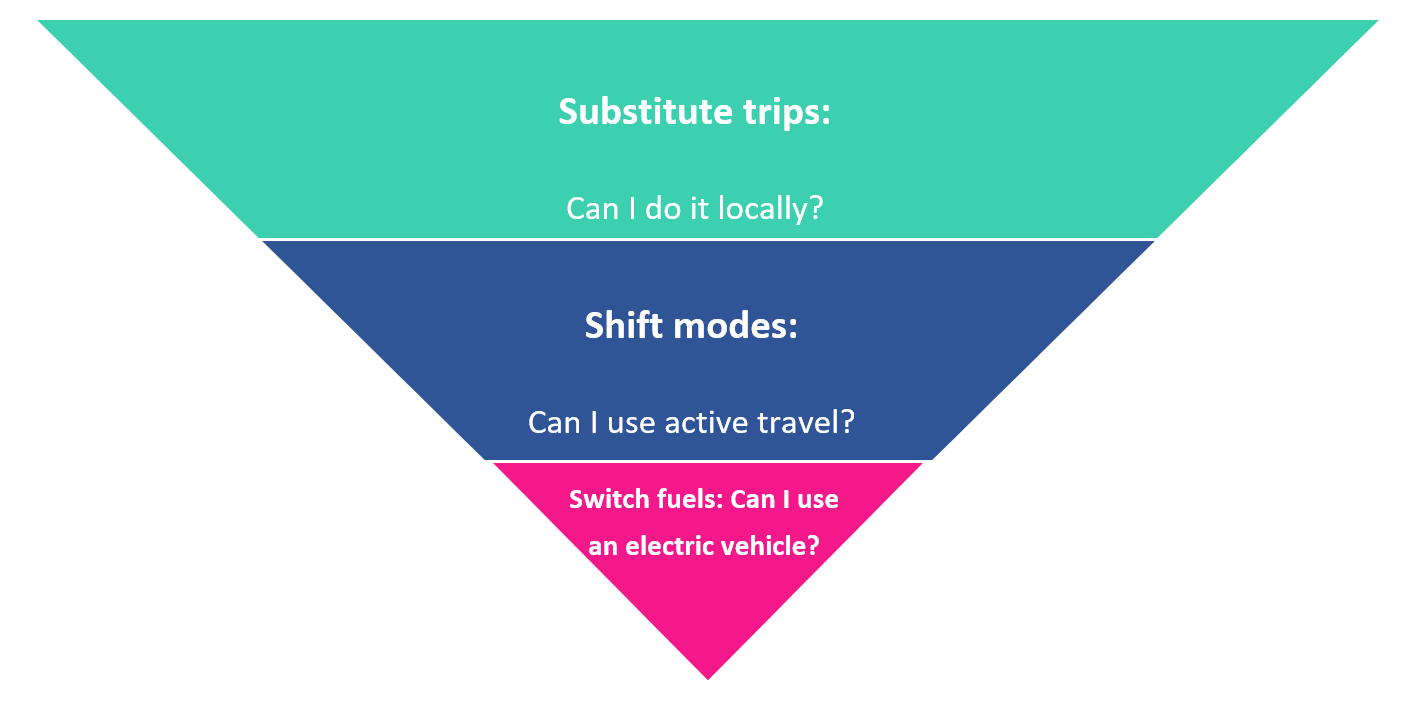
Figure 34: Sustainable Accessibility and Mobility (SAM) Framework Diagram (Source: Royal Town Planning Institute, Net Zero transport the role of spatial planning and place-based solutions, 2021)
7.279To help achieve this, the location of development in sustainable locations, and the supply of accessible sustainable transport modes, including walking, wheeling and cycling, will be prioritised. Roads will be carefully designed to support developments and minimise severance.
7.280We will also work in partnership with National Highways, Network Rail, Great British Railways Transition Team, Active Travel England and others to bring forward improvements to strategic transport infrastructure, services and freight movements. This will support local travel and also strategic movements.
TR1: Transport requirements for new developments
Vision-led transport planning
- All new developments, excluding householder applications, are required to embed the principles of the transport sustainability hierarchy, the National Planning Policy Framework’s vision-led approach to transport planning, and the Local Transport Plan. Where transport modelling is required, a range of plausible scenarios will need to be considered in line with a defined vision.
Delivering the vision
- All developments, excluding householder applications, will be required to demonstrate that they:
- Prioritise sustainable travel and integrate with existing sustainable transport infrastructure.
- Prioritise provision of routes within the site for pedestrians, those with impaired mobility, non-motorised vehicles and cyclists, which are designed to be coherent, direct, safe, comfortable and attractive.
- Strategic sites, major sites, and any other sites likely to generate significant amounts of movement, will be required to demonstrate through Transport Statements or Transport Assessments that they:
Walking, wheeling and cycling
- Provide new coherent, direct, safe, comfortable and attractive access to the site on foot, by cycle and other non-motorised vehicles, maximising connections with local services (including schools) and destinations and with existing footways, public footpaths, towpaths, bridleways, restricted byways and cycle ways. Whole route assessments will be required for a range of services and fully integrated routes should be provided addressing shortfalls in these routes.
- provide dedicated changing, storage and showering facilities in any new non-residential building over 2,500m2 of net internal floorspace.
- In relation to safe walking, wheeling and cycling to schools:
- Provide safe, direct and accessible walking, wheeling and cycling routes to schools for the development from first occupation, where that school is within statutory walking distance of the development (currently 2 miles under 8 years of age and 3 miles over 8 years of age).
- Work with the local authority to consider existing unsafe walking routes to school within statutory walking distance of the development, and opportunities to rectify them as part of the development.
Public Transport
- provide access to a high quality, fully accessible, attractive public transport service.
- provide a new or enhanced bus service where development is not already served by a high-quality attractive bus service. This may be provided directly or by way of a financial contribution, so that the service is maintained for a period of at least five years from an agreed occupation level.
- provide financial contribution towards a new or enhanced train service where required, if the development is not already served by a high-quality attractive train service.
Travel plans
- provide and implement travel plans that set out the long-term travel management strategy for an organisation or site, built on an appropriate package of measures aimed at promoting sustainable travel. They must include modal share targets and mitigation measures, in accordance with the Council’s guidance.
Car clubs
- provide car club infrastructure in the form of parking spaces, drop off and pick up points and, where appropriate, car club vehicles or provision of subsidised cost of car club membership for electric vehicles, in accordance with the Council’s car club guidance.
Car sharing
- provide priority parking spaces for car sharers at developments that are primarily destinations (i.e. non-residential uses).
Mobility Hubs
- deliver mobility hubs in accessible locations which are close to community facilities on site and provide sustainable transport connections to wider services, in accordance with the Council’s guidance.
Road Infrastructure
- provide strategic road improvements where required, ensuring minimal severance and connectivity provisions.
- where relevant, suitably assess and mitigate any cross-boundary impacts
Highways safety
- Development will be supported where there is no demonstrable unacceptable impact on highway safety, or the residual cumulative impacts on the road network, following mitigation, would be found less than severe, taking into account all reasonable future scenarios.
Rail safety
- Proposals that increase rail crossing use or affect accessibility will only be supported where there is no demonstrable unacceptable impact on railway safety.
Design Requirements
Design of transport infrastructure in new developments is required to:
- allow for bus routes through the site and priority routing of buses onto the main traffic network.
- include traffic management to mitigate any safety issues within and accessing the site, and any impacts of the development traffic on the main highway network.
- deliver a layout and design of transport infrastructure that creates high quality, permeable, coherent, safe and locally distinct places. Maximising opportunities for walking, wheeling and cycling should be given priority, followed by the needs of vehicular traffic
Vision-led transport planning
7.281The first part of the policy sets the strategic context for transport planning in Buckinghamshire. As an approach, a way of thinking or mindset, a vision-led approach to transport planning, as defined in the NPPF, is relevant to all scales of development and its application can be tailored accordingly. Therefore, all new developments need to contribute at scale to the transport objectives of the Local Plan and adopted Local Transport Plan. Where sites are allocated, the vision for these sites is set in the Plan.
7.282Transport modelling will still be necessary in vision-led transport planning. Developers will be required to model a range of plausible scenarios which assume different assumptions about trip generations and mode shifts.
7.283Plausible scenarios will be based on:
- characteristics of the proposed development site’s location,
- its existing connectivity,
- the mitigation or connectivity improvements that will be either delivered directly by the site developers or through financial contributions towards Buckinghamshire Council’s schemes and
- the extrapolation of trends in travel behaviour.
7.284Developers will need to engage at the earliest opportunity with the Highway and Planning Authorities to agree on a vision-led methodology.
7.285The Council will develop further guidance on vision-led transport planning.
Delivering the vision
7.286The second part of the policy focuses on how development proposals., in particular those requiring the submission of a transport statement or transport assessment (as set out in the Department for Transport guidance), will deliver the vision.
7.287The Council’s preferred way of achieving this will be via s278 agreements (rather than s106 contributions). Smaller developments though should make a proportionate contribution to the cost of delivering necessary schemes.
7.288Transport Assessments and Transport Statements primarily focus on evaluating the potential transport impacts of the development proposal and the scope/impacts/mitigation will vary from site to site. They may also consider net reductions of impacts and therefore no mitigation is required.
7.289Sustainable modes of transport should be prioritised in new developments to promote accessibility and integration with the wider community and existing networks. Priority should be given to walking, cycling, wheeling and access to public transport including the provision of new or enhanced existing bus services. It should be easier and quicker to walk, wheel or cycle to key locations across the site (and nearby) in order to encourage walking, wheeling and cycling to be the first choice for short trips. New developments need to consider access to and provisions at local rail stations to ensure that they can accommodate increased rail demand.
7.290As of December 2025, 1,058 children in Buckinghamshire qualify for home-to-school travel assistance due to unsafe walking routes, highlighting the importance of improving safe, active travel options. Encouraging walking, wheeling and cycling to school supports children’s health and wellbeing, particularly given that only 51.9% meet recommended daily physical activity levels, while also helping to reduce congestion, emissions and air pollution around schools, where children are especially vulnerable. This approach aligns with LTP5 objectives and will be supported through the Local Plan. Developers should ensure that all schools for new developments have safe, direct, accessible walking and cycling routes both within the development and also take into account routes children and young people might take into schools on new developments from outside the development, or from the development to schools outside of it.
7.291People also need access to open spaces and recreational facilities and should be able to easily get there by walking/bike. These spaces are going to be used for walking/cycling; therefore, provisions should be made for walking/cycling routes through all green spaces.
7.292Developers will need to refer to the latest detailed guidance from the Highway Authority, including on Travel Plans6, Car Clubs and Mobility Hubs. Cycling provision must follow LTN1/20 guidance, or any future update to it, subject to safety requirements.
7.293The vision-led approach recognises that journeys by car will still be required. To support those that need to drive, measures should be included to encourage zero emission vehicles, car sharing, and reduce journey lengths such as mobility hubs. The design of developments should also ensure motor vehicle movements are routed appropriately.
7.294To ensure that all transport users’ needs are considered and genuine travel choice is provided in new developments, highway upgrades for cars / HGV use should only be considered after all other options have been explored.
7.295A car club provides access to private vehicles for hire. The cars are usually parked in reserved parking spaces specifically for car club vehicles. They provide more sustainable vehicles and travel choice.
7.296The guidance will support the parking standards and will outline the benefits of car club schemes, the types of schemes, operational models and management, and the parking space requirements (location, infrastructure and design).
7.297A mobility hub is a physical location that facilitates the integration of multiple transport options e.g. buses, trains, bicycles, e-scooters and carsharing services making it easier for people to switch between different types of transport. In Buckinghamshire, mobility hubs will facilitate and enhance connections between new developments, existing rail and bus interchanges and key tourist and employment zones.
7.298Where and how mobility hubs are implemented will vary depending on specific site constraints, existing transport provision, user demand, future transport and economic trends. Developers should refer to the Parking Standards for New Developments and Mobility Hub Guidance to ensure that the right mix of sustainable transport modes are viably implemented and in the right locations.
7.299The Council is currently developing Mobility Hub guidance as part of LTP5 which will outline the types of mobility hubs, where they are likely to apply and the proposed mix of components for each mobility hub types. The guidance will outline minimum requirements that each mobility hub must meet.
Highway safety
7.300In line with the NPPF, developments should not have a severe adverse impact on the operation of the network. Mitigation following a vision-led approach will need to be provided as appropriate.
7.301Developers will need to liaise with the Council and neighbouring Councils to appropriately address cross boundary impacts as part of their planning application.
Rail safety
7.302Proposals which materially affect rail crossing will need to demonstrate, in consultation with Network Rail, how safety considerations are considered, and deliver mitigations as necessary.
Design requirements
7.303Detailed design requirements will need to be discussed and agreed at the earliest opportunity with the Highway Authority.
TR2 - Transport improvements
Policy TR2: Transport improvements
Development will not be supported where they would prejudice the provision of new or improved safeguarded highways infrastructure, as shown on the Policies Map.
The following schemes are safeguarded by this plan:
- Eastern Aylesbury Link Road (south) (between A41 and Mike Griffin Way).
- Southern Aylesbury Link Road (between A41 and A413).
- Southeast Aylesbury Link Road (between A413 and B4443).
- Southwestern Aylesbury Link Road (between A4010 and A418).
- Northeast Aylesbury Link Road (NESS Site) (between A413 and A418).
- Wing West Link Road (between Cublington Road and Stewkley Road).
- Buckingham South Link Road (between the A413 to the A421).
- Princes Risborough Relief Road (between Shoot acre Lane junction with A4010 and Grove Lane junction with A4010 via the NESS site).
- Whaddon bypass (between Coddimoor Lane and Nash Road).
- Horton bypass (between B488 Horton Road / Station Road junction and B488 North via Land at Horton).
- A421 capacity improvements (between Bottledump Roundabout and A421 / Coddimoor Road / Whaddon Road roundabout).
- Winslow Link Roads (between A413 Buckingham Road and Great Horwood Road; and between Great Horwood Road and Little Horwood Road)
Development will also not be supported where it would prejudice the delivery of Transport Improvement Lines identified on the council’s website.
Major development sites are required to identify, protect and help to deliver strategic transport infrastructure, both existing and new, where there is robust evidence, the infrastructure is critical to widening transport choice and realising opportunities for large scale development, and prevent severe transport impacts on the highway.
7.304In line with the Highway and Planning Authorities' priorities, the local plan formally safeguards Highways schemes on the Policies Map, and Transport Improvement Lines through this policy to ensure that no development could prejudice the delivery of these schemes.
7.305The Council will not permit development that would prejudice the implementation of any of the schemes safeguarded by the Council (see list above and see transport improvement lines on the website). There are different types of road and junction improvement lines, and they are required to provide improvements to road networks, to increase road capacity, improve road safety, as well as creating additional public transport or non-vehicular routes for walking, wheeling and cycling.
7.306In addition, major development sites are required to identify, protect and deliver strategic transport infrastructure where there is robust evidence it is critical to widen transport choice or support delivery of large-scale development. Strategic transport infrastructure may be required to improve the current transport network or support future travel requirements.
7.307Strategic transport infrastructure includes new roads, improvements to road networks and creation of additional public transport (bus or rail), or non-vehicular routes for walking, wheeling and cycling. Infrastructure will be delivered on site or through contribution towards its delivery. Due to the nature of Buckinghamshire, roads will remain an important part of strategic transport infrastructure.
7.308Developers will need to liaise with the Council and neighbouring Councils to appropriately address cross boundary impacts as part of their planning application.
TR3 - Parking standards
Policy TR3: Parking standards
Standards
- Development proposals are required to comply with the latest Buckinghamshire Parking Standards for new developments in appendix I and the design principles in the national design guide.
Controlled parking zones (CPZs)
- Controlled Parking Zone (CPZ) is an area where parking is managed to regulate use, prioritise users and support safe and efficient access.
- CPZs must be considered where development is likely to result in parking demand exceeding available capacity, or where unmanaged parking would give rise to safety, access or operational issues.
- Developments proposing reduced or shared parking provision, including within the Town Centre Zone and other highly accessible locations, must implement CPZs where necessary to manage on-street parking demand, support safe access and enable the effective operation of the highway network.
*Parking standards are regularly being reviewed, and this policy refers to the prevailing standards at the time planning permission is granted.
7.309The Parking Standards for New Developments provide the requirements for parking provision and management in new developments. The standards reflect what the council deems as the most appropriate amount of parking that should normally be met to support growth without causing adverse effects to our residents, visitors and neighbourhoods.
7.310Parking plays a significant role in shaping Buckinghamshire’s people and places. Insufficient parking can constrain economic activity and lead to inappropriate or unsafe parking behaviour, while excessive parking can consume valuable land and make places harder to navigate. Providing suitable parking facilities for wheelers, cyclists and motorcyclists is essential to support sustainable travel, and ensuring adequate disabled parking for Blue Badge holders is also vital for mobility and independence.
7.311Electric vehicle (EV) charging infrastructure must be provided in all new developments in line with current government regulations and the requirements set out in the Parking Standards for New Developments. EV parking spaces will typically be counted as part of, and not in addition to, the defined parking standards. Installations should be technologically advanced, widely accessible, reliable and include consideration for alternative fuel vehicle technologies.
7.312Policies within the NPPF have given local authorities the flexibility to tailor parking provision based on local market demands, community needs and future transport ambitions. Recent NPPF policy changes favour dense developments in accessible places, emphasise the importance of active travel and public transport networks and establish clear expectations for parking provision to align growth with sustainable transport options.
7.313Buckinghamshire’s Local Transport Plan sets out the local priorities for promoting modal shift and influencing the quality and character of local streets. The Parking standards takes the many demographic and economic variations in Buckinghamshire’s urban and rural areas as well as the significant variations in accessibility of public transport and reflects these variations in the parking standards to ensure adequate parking provision. The standards also provide flexibility where there are evidenced circumstances to justify deviations reinforcing the need for context-based parking.
7.314The requirement for a CPZ will be determined based on the scale, location and impact of the development. Where they are required, clearly defined and agreed management arrangements must be in place to ensure their delivery, operation and long-term management is secured as part of the development, including appropriate funding and interim arrangements prior to adoption where applicable. CPZs must also be subject to ongoing monitoring and periodic review to ensure they remain effective and respond to changing demand over time. The introduction of CPZs is subject to formal processes and statutory requirements. Further information on Buckinghamshire Council’s approach to delivery and implementation is available here.
7.315All development proposals are required to comply with the parking standards as they will be a material consideration for the determination of planning applications and progressing the Local Plan development plans and the Local Transport Plan (LTP5) transport priorities.
TR4 - Public rights of way
Policy TR4: Public rights of way
1. Development will be required to:
- Protect and enhance public rights of way to ensure the integrity and connectivity of this network is maintained.
- Ensure the safe and convenient use and enjoyment of existing public rights of way, such as footpaths, bridleways and restricted byways, is maintained.
- Upgrade existing permissive path to bridleway, where agreements are in place at the time of the commencement of the local plan.
- Avoid unacceptable harm to the efficient operation of public rights of way.
2. Proposals should accommodate existing access routes on their original alignment through green corridors. If diversions are required to enable a proposal to come forward, this will only be supported if the safety and convenience of the route is of similar or greater merit than the existing.
3. Proposals should seek to upgrade the status and improve the connectivity of public rights of way to maximise sustainable transport networks, where necessary, to allow additional use by cyclists.
4. New routes used for active travel, both on- and off-site, should be upgraded to adoptable standard to support increased use, providing an attractive travel choice. They should be safe by design and, within new developments, overlooked by active frontages.
7.316As of June 2025, there are 2,084 miles of public rights of way in Buckinghamshire which form the primary means by which residents and visitors access the countryside, but also schools and workplaces. Management of the network is guided by the Buckinghamshire Rights of Way Improvement Plan 2020-2030, which acknowledges the network’s critical role in the rural economy.
7.317Public rights of way are complimentary to the footway and cycleway network for walking and cycling which will contribute to the delivery of the Buckinghamshire Local Cycling and Walking Infrastructure Plan (LCWIP).
7.318The Local Plan will seek to protect this resource and ensure improvements or enhancements are secured through the planning process to encourage active travel by new residents and discourage short journeys by car.
7.319The protection and conservation of public rights of way need to be reconciled with the benefits of new development, to maximise the opportunity to form links from the development to the wider public rights of way network, public transport, recreational facilities and green infrastructure.
7.320When delivering sustainable transport solutions, there may be instances where it is necessary to upgrade public rights of way as an alternative to the highway network. For example, to upgrade part of a public footpath to public bridleway or cycleway.
7.321Any changes to a public right of way will require a separate legal process, either under s257 Town and Country Planning Act 1990 (as amended by subsequent legislation) if impacted directly by a development’s footprint or otherwise under s119 Highways Act 1980 (as amended by subsequent legislation). The diverted route should be of similar or greater merit than the existing.
TR5 - Freight and logistics
Policy TR5: Freight and logistics
1. Proposals which facilitate modal shift to rail freight will be supported.
2. Facilities that enable sustainable freight activity and first mile / last mile solutions, in accordance with the adopted Local Transport Plan, will be supported.
3. Smart warehousing through retrofitting of existing stock will be supported.
4. New proposals (temporary or permanent) for freight and logistics movements should not have a significant detrimental impact on the local area.
5. Developments with retail or food-retail must ensure suitable access arrangements, loading and unloading facilities are provided.
6. Employment sites must have suitable facilities and access arrangements for ongoing freight deliveries.
7.322Local authorities are required to plan for the modern economy; this includes freight and logistics. Freight is essential for servicing industry, communities, and supporting economic development. The Council is working on updating its Freight strategyalongside the Local Transport Plan 5.
7.323The transportation of goods by freight (road and rail) plays a key role in servicing Buckinghamshire’s industry, communities and enabling our growth and economic development. Freight offers our residents choice as consumers and businesses: allowing them to grow, thrive and develop.
7.324As identified in our draft Freight and Logistics Strategy, the Council supports the modal shift to rail freight to help reduce transport emissions and vehicle traffic in our towns and villages. Modal shift to rail will also support national decarbonisation targets and the Office of Rail and Road’s freight growth forecasts. The Council will continue to work with partners to prioritise rail freight infrastructure investment and protect strategic freight sites where appropriate. A revised freight and logistics strategy is being prepared to support LTP5.
7.325Whilst we recognise the importance of road freight, there are also local challenges with the movement of goods by road. This includes freights contribution to transport carbon emissions and local traffic or road safety issues. Therefore, where deliveries are required, developments need to ensure appropriate access, loading and unloading arrangements. The draft Freight and Logistics Strategy highlights that we will work to make Construction Traffic Management Plans a default requirement for all planning proposals of a significant scale or where there is a reasonable expectation that there would be a risk of disruption to the local community during the construction phase. We will also support measures to enable sustainable deliveries and contribution towards our net zero ambitions.
7.326As the most established modern economy presence within Buckinghamshire (freight and logistics dominate the employment figures at both the Buckinghamshire and national level, representing 72.1% of modern economy roles in Buckinghamshire in 2023), there are many businesses within the wider freight and logistics supply chain. Most prominently, these businesses are wholesalers, including pharmaceuticals, food and agricultural products, and office machinery and equipment. These businesses are positioned along key road connections, with clusters in and around the main settlements and business parks.
7.327The Council is involved in developing a regional freight strategy as part of its involvement in England’s Economic Heartland. Buckinghamshire’s relative lack of strategic freight infrastructure such as ports, airports, and rail freight terminals limits its potential comparative advantage in the sector. Conversely, logistics, which includes warehousing and storage, demonstrates considerably stronger demand conditions, indicative of excess demand for logistics services.
7.328The Employment Land Review Modern Economy Report has concluded that there is a need for smart warehousing via retrofitting of existing stock (pre-2000 for most) which would improve their efficiency through digitalisation and automation.
TR6 - Aviation development
Policy TR6: Aviation development
- Aviation development that affects Buckinghamshire, including flight paths and construction traffic, will only be supported where it would not have a significant adverse impact on:
- the environment, landscape, nature conservation interests and
- residents and businesses in terms of noise, adverse lighting, residential amenity, public rights of way, or health and safety.
- Diversification of operational airfields to include wider economic uses is supported, provided it does not prejudice or limit their effective aviation operation.
- Development which would interfere with the safe operation of an aerodrome or with the movement of air traffic will not be permitted. Any proposed development within a statutory or non-statutory Safeguarding Zone which is, in principle, acceptable will need to be safely designed in accordance with each aerodrome’s safeguarding maps.
- Any proposed development within an identified Aviation Safeguarding Zone will be subject to consultation with the operator of the aerodrome and the Ministry of Defence.
7.329The Council will seek to mitigate severe impacts from aviation developments where applicable. National guidance to local planning authorities is included in the DfT’s general aviation handbook[19].
7.330Local airfields are important local facilities. On small airfields such as Denham the Council will seek to ensure that proposals do not prejudice the operational users already in place.
7.331In relation to major airports in adjacent authorities, namely Heathrow and Luton, development in Buckinghamshire should not prejudice the safe operation of these international airports.
7.332This policy ensures that there is no interference with the safe operation of an aerodrome or the movement of air traffic. There are several statutory and non-statutory aviation safeguarding zones from airfields within Buckinghamshire, as well as airports and airfields within neighbouring authorities. Safeguarding zones are identified by each aerodrome based on their operational requirements. Restrictions in height, placement of buildings and equipment or changes to the detailed design of development may be necessary to mitigate the risk of aircraft accident and interference with equipment to maintain operational integrity.
TR7 - High Speed Two and East West Rail – delivery and restoration
Policy TR7: High Speed Two and East West Rail – delivery and restoration
High Speed Two
- Development which would prejudice the implementation of High Speed 2 (HS2) will not be supported.
- New development must consider HS2 Railway Line by:
- Ensuring it does not affect HS2 programme delivery.
- Managing its construction to minimise cumulative impact on communities, highways and the environment and
- Making use of careful design to protect communities and the environment from noise, visual intrusion, loss of accessibility and impacts on biodiversity, mitigating impacts where practicable from the construction and operation of the HS2 Railway Line.
- Development proposals should ensure they do not prejudice the long-term establishment and protection of environmental mitigation, including woodland, hedgerows, grassland, ecological habitats and landscape screening required to offset the impacts of the railway.
East West Rail
- Development which would prejudice the implementation of East West Rail (EWR), including the scheme known as the EWR Aylesbury Link (Aylesbury station to Claydon Junction), and future capacity upgrades to the Aylesbury to Princes Risborough Line, will not be supported.
- Development should not prejudice future overhead line electrification of the EWR Aylesbury Link and / or the Aylesbury to Princes Risborough Line, as shown on the Policies Map.
- Development of land adjoining the EWR Aylesbury Link or the Princes Risborough to Aylesbury railway line must not prejudice the future doubletracking of these lines.
- New structures proposed to be introduced across the EWR Aylesbury Link or the Princes Risborough to Aylesbury line shall make passive provision for future doubletracking and for future overhead line electrification.
- Development proposals should ensure they do not prejudice the long-term establishment and protection of environmental mitigation, including woodland, hedgerows, grassland, ecological habitats and landscape screening required to offset the impacts of the railway.
High Speed 2
7.333High Speed 2 (HS2) is a Nationally Significant Infrastructure Project that will link London to Birmingham. The Secretary of State for Transport issued a safeguarding direction for the route between London and Birmingham in July 2013. The HS2 Act received Royal Assent in February 2017. The safeguarded land runs through the centre of the county (south to north) and is shown on the Policies Map. The safeguarding directive requires the notification to HS2 Ltd of any planning application which affects the safeguarded land. The purpose of the safeguarding is to avoid conflicting developments during HS2’s construction and implementation.
7.334The consenting and construction of HS2 will continue to be progressed during the Local Plan period. As the railway line has deemed planning permission and is a Nationally Significant Infrastructure Project (NSIP) it is important new development proposals do not hinder or delay its implementation. The HS2 proposals within the safeguarded area are not consented through the development plan process: there are specific consenting requirements set out within the HS2 Act.
7.335The HS2 Act requires schemes of mitigation to reduce the impacts of the railway line within its locational context. The key mitigation measures relate to noise, landscape, and ecology. To ensure the consented level of mitigation remains in place for the operational lifetime of the railway as consented under the HS2 Act no development should alter or remove the mitigation provisions that have been approved and implemented. This is to protect the surrounding communities, heritage assets, and environment.
East West Rail
7.336The delivery of East West Rail (EWR) is vital for the subregion’s prosperity and for improving sustainable travel alternatives to the car for commuting and leisure.
7.337The EWR project is aiming to provide connectivity to Reading, Didcot, Oxford, Bicester, Aylesbury, Milton Keynes, Bedford, Cambridge, Norwich and Ipswich and supports sustainable growth across the corridor. EWR Connection Stage 1 (Bicester to Oxford) is in operation and preparation for Connection Stage 2 (Bicester - Milton Keynes) is well advanced. Connection Stage 3 (Bedford and Cambridge) is currently in the planning stage.
7.338Connection Stage 2 involves the upgrade of the line linking Bedford to Bicester and Milton Keynes, via Winslow. This will allow passenger and freight services to run between Bedford, Milton Keynes, Bletchley and Bicester, with a new station in Winslow. EWR are also proposing a traction maintenance depot in Buckinghamshire to the west of Bletchley, as well as passing loops for freight in the same area.
7.339Proposals by EWR Company and the Department for Transport do not currently include provision for the East West Rail Aylesbury Link (Aylesbury station to a mainline connection at Calvert Junction). This Link would enable direct services from Aylesbury and Aylesbury Vale Parkway to Winslow, Bletchley, Milton Keynes and other destinations to the north and east. Services would run via an upgraded existing freight-only line north from Aylesbury Vale Parkway, joining East West Rail at Claydon Junction. Provision for the Aylesbury Link is already being partially delivered by the HS2 programme as part of its reinstatement works for the former single-track line in the Calvert and Claydon area.
7.340A key priority in the Council’s Economic Growth Plan and Local Transport Plan 5, the Council strongly supports delivery of the East West Rail Link to Aylesbury. This is to include a continuous two-track (double tracking) railway corridor between Aylesbury railway station and Claydon Junction, as well as provision for future overhead line electrification (OLE). Albeit at an early stage of planning, it is appropriate to ensure that development adjoining the line does not prejudice the future implementation of this route. Similarly, any structures proposed to be introduced across the route should be designed to accommodate future twin tracking or OLE. This is known as passive provision.
7.341In that context, applicants within 50 metres of the proposed Link are encouraged to consult Network Rail and operators at the earliest opportunity.
7.342Contributions may be sought from development sites along the route of the EWR Aylesbury Link that are likely to benefit from proximity to stations along its route and the increased rail connectivity it will afford those sites.
Princes Risborough to Aylesbury line
7.343The Princes Risborough to Aylesbury line is currently a single-track line serving Monks Risborough and Kimble stations. Double tracking of this line was identified by Network Rail in their West Midlands and Chilterns Route Study 2017. This scheme would provide an increase in service capacity and therefore support the increased rail demand expected due the forecast housing and economic growth in Buckinghamshire.
7.344The Council strongly supports the mid to long-term aspiration of Network Rail to double track the Princes Risborough to Aylesbury line. Albeit at an early stage of planning, it is appropriate to ensure that development adjoining the line does not prejudice the future implementation of this scheme.
7.345In that context, applicants bringing forward proposals within 50 metres of the branch line are encouraged to consult Network Rail and operators at the earliest opportunity.
7.346Restored land linked to these two national transport projects will need to be carefully managed to maximise benefits for Buckinghamshire residents and nature. The Council will continue to work with partners towards delivering value for money outcomes, where this is within its remits. The Local Plan policies will only apply where there are applications under the Town and Country Planning Act. HS2 and EWR are largely consented through national legislation, which will fall outside the Local Plan.
TR8 - Buckinghamshire Greenway
Policy TR8: Buckinghamshire Greenway
1. The Buckinghamshire Greenway, a new Transport Improvement Line, is proposed as a new walking / wheeling /cycling route, as shown on the Policies Map.
2. Developments will not be supported where they would prejudice the delivery of a of a 5m wide walking, wheeling and cycling corridor. This route is to be separated from vehicular traffic with an appropriate buffer width where practicable. In circumstances where it is demonstrated that available width is constrained, a localised narrowing to provide a 3m wide surfaced path may be accepted.'
3. To maximise the opportunities for walking, wheeling and cycling, the development of major sites (10 or more homes or employment equivalent) within 800 metres of the corridor will be required to make proportionate contributions to construction of the greenway and/or provide convenient links to the route, and sections of the route, where there is no obvious / overriding issues of topography, traffic or other severance and where it is practicable to create/deliver links and /or route sections.
4. Any future development proposals that would prejudice construction or operation, or prevent suitable diversions being created to provide the walking, wheeling and cycling corridor, will not be supported.
7.347The Buckinghamshire Greenway is the proposed flagship active travel route ‘spine’ running north-south across Buckinghamshire. The Greenway is identified in the Buckinghamshire LCWIP and will be an accessible, high quality active travel route that will connect people and communities.
7.348It will be the walking and cycling backbone for everyday trips in Buckinghamshire, connecting with both existing active travel routes and other new routes currently in development. It will form the core spine of the Buckinghamshire LCWIP network. The Greenway will also connect with rail and bus services.
7.349The Greenway will:
- Open new opportunities to access services such as education, healthcare and employment.
- Provide an attractive and safe active travel alternative for local journeys.
- Be a local leisure and tourism asset for Buckinghamshire through the Chilterns national landscape and to key tourist destinations.
7.350The Greenway also supports a wider vision for a north south National Cycleway connecting London and the West Midlands, and communities between.
7.351The Greenway has been split into discrete route sections to enable progressive delivery. Each section serves as a key inter-settlement link, as well as forming part of the wider countywide route. The first section to be delivered in 2018 was between Aylesbury Vale Parkway Station and Waddesdon Manor (Waddesdon Greenway), with the section between Wendover Dean and Great Missenden (Misbourne Greenway) completed in 2025.
7.352Future sections may include delivery of cross-border links, and continued partnership working with neighbouring authorities will be important to ensure their effective delivery.
7.353Delivery of the Greenway will be key to enabling more people to choose to walk, wheel and cycle. This will support delivery of our Local Plan and Local Transport Plan visions. Benefits of more people being able to choose to walk, wheel and cycle will include reduced congestion, reduced emissions and improved health. The Greenway will also support the local economy through improved access to job opportunities and visitor attractions.
7.354To this effect, a buffer of 800 metres from the corridor boundary is proposed to capture s106 contributions from major sites (10 or more homes or employment equivalent). This corresponds to a 10 minutes’ walk / 3 minutes cycling and is deemed reasonable.
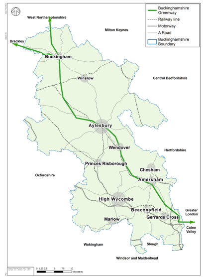
TR9 - Former Bourne End to High Wycombe to railway line
Policy TR9: Former Bourne End to High Wycombe railway line
1. The former Bourne End to High Wycombe Railway Line is proposed as a new walking / wheeling /cycle route as shown on the Policies map.
2. Developments will not be supported where they would prejudice the construction of a 5m wide walking, wheeling and cycling corridor between Bourne End and High Wycombe town centre/railway station, utilising the track bed of the Bourne End to High Wycombe disused railway line. This route is to be separated from vehicular traffic where practicable. If in creating this new route, it is necessary to make diversions from the former railway track bed, the route chosen should not be significantly less direct or attractive.
3. The development of major (10 or more homes or employment equivalent) sites within 800 metres of the corridor will be required to make proportionate contributions to construction of the route and/or provide convenient links to the route (and sections of the route where appropriate), in order to maximise the opportunities for walking, wheeling and cycling.
4. Any future development proposals that would prejudice construction or operation, or prevent suitable diversions being created to provide the walking, wheeling and cycling corridor, will not be supported.
7.355The track between High Wycombe and Bourne End was closed in 1970 and has been safeguarded since 1976. The Delivery and Site Allocations Plan for the former Wycombe District safeguarded the route in 2013 for its potential to be developed as a high-quality public transport corridor.
7.356A study[20] recommended that “the relevant local authorities should prevent further development along the alignment, so that the route is preserved in the event of the case for the re-instatement of public transport route here strengthening in the future.”
7.357Following further work the Council considers that the prospects for a public transport route being created are now very unlikely. However, the route does offer great potential as a walking and cycling route as it is direct and well connected to homes, schools, jobs, railway stations, open space and town/district centres on a largely flat, largely traffic free route through an attractive landscape. The route – much of which remains undeveloped - is therefore safeguarded for the provision of a dedicated walking/wheeling/cycling route. The route also has potential to enhance green infrastructure. It is identified in the emerging Local Nature Recovery Strategy as an Area that Could Become of Particular Importance for Biodiversity.
7.358Creation of an active travel route along the former railway line would deliver economic and health benefits by encouraging cycling, wheeling and walking and could form part of the Sustrans National Cycle Network. Its route along the valley floor is well positioned, as it runs through/is adjacent to urban areas for almost all its length – close to schools, houses, work places, rail stations and town /district centres, so it could be used for all types of cycling and walking journeys and in many places could be separated from vehicular traffic in order to make this route more attractive to users. Studies have shown it is not otherwise practicable to meet modern design standards for a cycle route between High Wycombe and Bourne End.
7.359The Council will seek delivery of convenient links to the route, and sections of the route where appropriate, through direct delivery or s106 contributions as necessary. In this case, where appropriate means where there are no obvious / overriding issues of topography, traffic or other severance and where it is practicable to create/deliver links and /or route sections.
7.360To this effect, a buffer of 800 metres from the corridor boundary is proposed to capture s106 contributions from major sites (10 or more homes or employment equivalent). This corresponds to a 10 minutes’ walk / 3 minutes cycling and is deemed reasonable.
Infrastructure
IN1 Infrastructure delivery
Policy IN1: Infrastructure delivery
- The level of infrastructure required to support development will be determined having regard to the existing level of infrastructure provision; relevant standards set out in this Local Plan; and The Council’s latest Infrastructure Delivery Plan.
- Development proposals must ensure that appropriate infrastructure is provided to support the scale and nature of the development.
- Development will be permitted only where adequate infrastructure capacity is already in place, or where the development delivers or secures the infrastructure necessary to fully mitigate its impacts.
- The delivery and phasing of development must coincide with the timely provision of necessary infrastructure.
- Where infrastructure cannot be delivered in a timely manner, land must be safeguarded to enable future delivery.
- Infrastructure must be planned for and delivered holistically where two or more development sites/areas have shared or linked infrastructure needs. Impacted parties must demonstrate cooperation and collaboration and provide evidence of agreements made to show that the infrastructure needs will be met.
7.361Planning for sustainable growth relies on ensuring that new development is supported by the infrastructure needed for communities to function well. The NPPF emphasises the importance of planning for infrastructure alongside new development and the Local Plan plays a key role in identifying what infrastructure is required and how it will be delivered. This policy provides the framework for coordinating development with the right infrastructure at the right time. The Topic Paper on Infrastructure and Community Facilities sets out how the Council engaged with infrastructure stakeholders to assess infrastructure requirements for the Local Plan. It also explains the framework for their delivery.
7.362As development comes forward, it can generate additional demand for facilities such as schools, healthcare, transport, open space, utilities and digital connectivity. Without appropriate provision, this can lead to increased pressure on existing facilities. It is important therefore to ensure that development either makes use of suitable existing infrastructure where capacity exists or contributes towards new or improved provision where necessary to mitigate its impacts.
7.363Different developments will affect infrastructure in different ways, and a range of measures may be needed to address these impacts. In practice, this might include on‑site works, off‑site works, or securing land for future community facilities. Financial or non-financial planning obligations may also be used where appropriate. These measures should be proportionate so that obligations relate directly to the scale of the impacts being created. Planning obligations are an established mechanism for securing both financial contributions and direct delivery of infrastructure. Some types of infrastructure, such as wider transport improvements, strategic drainage works or larger community facilities, serve more than one development site or area. In such cases, pooling contributions can be necessary to assemble sufficient funding and is most relevant where several developments rely on the same piece of infrastructure or where delivery requires a coordinated approach.
7.364Where an infrastructure project depends on multiple partners or funding sources, applicants should demonstrate how their contributions align with other programmes or responsibilities. This helps ensure that delivery is realistic and coordinated, and that developments are not delayed by unclear roles or funding gaps.
7.365Infrastructure requirements should be based on up-to-date evidence. This may include standards and information in this Local Plan, the Infrastructure Delivery Plan (IDP), topic-based assessments and discussions with infrastructure providers and statutory bodies.
7.366Timing of delivery is a critical element of good planning. Applicants should therefore set out how infrastructure will be phased, including what they will deliver directly and what depends on external providers. Clear triggers, such as occupation thresholds or completion of particular phases, help ensure that infrastructure is available when it is needed and prevents unnecessary pressure on existing services.
7.367In some cases, infrastructure cannot be delivered immediately because detailed design, funding or provider-led programmes will only come forward at a later date. Safeguarding land allows development to proceed without compromising future opportunities to deliver key infrastructure. Obligations may secure land reservation or transfer, providing certainty that the land will remain available if needed. Where safeguarding is required, master planning can be used to explain how the safeguarded land fits within the wider site layout, including access, movement, service corridors and relationships with open spaces and development parcels. The length of the safeguarding period should reflect the expected build-out of the development and the likely timescales of infrastructure providers.
7.368Larger developments or areas with multiple landowners frequently require shared or strategic infrastructure, such as main access roads, utility upgrades, walking and cycling networks, public transport links, or community and green infrastructure. To support coordinated delivery and avoid piecemeal arrangements, the policy expects collaboration between applicants. This might involve joint master planning, common design principles, agreed phasing strategies and/or cost sharing arrangements.
7.369Buckinghamshire is a predominantly rural county with a dispersed settlement pattern. As such, car travel remains an essential and integral part of everyday life for many residents and businesses and the road network plays a critical role in supporting connectivity, access to services and economic activity. Further detail on requirements for transport and digital infrastructure is set out in Policy SP10.
Healthcare and education infrastructure
IN2: Healthcare and education infrastructure
- Development proposing 10 or more dwellings will be required to provide healthcare and education infrastructure necessary to meet needs arising from the development, either through on-site provision of new or improved infrastructure or from contributions secured through planning obligations.
- Healthcare contributions will be calculated in accordance with the methodologies set out in Appendix O.
- Education contributions will be calculated using a robust and up-to-date methodology based on evidence of pupil yield, school capacity and cost of provision, consistent with Department for Education (DfE) guidance.
7.370Healthcare and education infrastructure is essential to support sustainable communities, and planned growth will increase its demand. New development must therefore mitigate its impacts through appropriate provision or contributions. The Infrastructure and Community Facilities Topic Paper describe the Council’s work on the need for new schools and with healthcare providers. It sets out how the impacts of Local Plan growth were assessed and the actions needed to mitigate those impacts.
7.371On-site provision of new or improved healthcare and education facilities will be identified and secured through site-specific allocation policies and/or the Council’s Infrastructure Delivery Plan. Where on-site provision is not explicitly required, financial contributions towards healthcare and education infrastructure to mitigate the impacts of development will be secured.
7.372Healthcare contributions will be calculated using the Council’s locally defined methodology set out in Appendix O.
7.373This ensures a consistent and transparent approach to identifying the scale of impact and level of mitigation required. This work has been based on information about primary healthcare needs from the Thames Valley Integrated Care Board (ICB) and from the Buckinghamshire Healthcare NHS Trust which provides acute and community healthcare in Buckinghamshire.
7.374For education, the Council will apply a consistent methodology based on Department for Education (DfE) guidance on securing developer contributions. This approach uses locally derived pupil yield evidence to estimate the number of places generated by development, considers the capacity of existing schools, and applies appropriate cost assumptions to identify the level of contribution required. Contributions will only be sought where additional places are required, having taken account of forecast school capacity, and will be proportionate to the scale and nature of the development.
IN3 Water infrastructure
Policy IN3: Water infrastructure
Water supply
1. Developments are required to demonstrate how they will be served by adequate water supply infrastructure. Capacity of distribution systems must be demonstrably adequate prior to occupation of development.
The location of, and likely impact on, private water supplies within Buckinghamshire must also be considered in ensuring that there is adequate water infrastructure capacity in place to serve development.
Wastewater
2. Developments are required to demonstrate how they will be adequately served with foul drainage, wastewater and sewage treatment without leading to significant problems for existing users or contamination of waterbodies and water supply.
3. Planning applications must demonstrate that adequate capacity of distribution systems is available or can be provided within the foul sewerage network and at wastewater treatment works in time to serve the development.
4. The Council will expect new development (new buildings such as new dwellings and employment units) to connect to mains foul drainage and will restrict the use of non-mains drainage for foul water disposal, in line with Environment Agency guidance.
Delivery
5. Phasing conditions will be attached to planning permissions to ensure that new developments are not occupied until the required water supply, and wastewater capacity is in place.
New and Enhanced Water Services Infrastructure
6. Applicants are not required to demonstrate the need for water infrastructure developments. In considering proposals for water supply, drainage and wastewater development, substantial weight should be given to:
a. The benefits of providing the capacity needed to serve proposed development as well as improving the security of supply and capacity for existing users (both residential and commercial, including agricultural users); and
b. Improving water quality and reducing water-borne pollution.
7.375Water resources need to be safeguarded from the potentially negative impacts of development. This includes pollution from wastewater.
7.376The Local Plan for Buckinghamshire provides information on the growth required and estimated during the plan period and the National Planning Policy Framework supports the need to make sufficient provision for water supply in those locations.
7.377Buckinghamshire Council working in partnership with key stakeholders has developed a Water Cycle Study that sets out existing issues at the time of the study and where upgrades are needed. The outcome of the Water Cycle Study is fed into the Local Plan which then can be used by water companies to finalise future asset management plans. 34 of the Wastewater Treatment Works require an upgrade to accommodate the local plan housing growth. The Study also identifies odour buffers for sites including 28 site allocations due to proximity to a treatment works. At Princes Risborough and RAF Halton treatment works, there is a possibility that growth may impact on the flood risk of receiving waterbodies. Water quality modelling has found that local plan growth would result in a deterioration at around half the modelled wastewater treatment works. In terms of water quality, the study confirms that growth alone will not prevent a good ecological status being achieved in watercourses.
7.378Early engagement between developers and water supply and wastewater companies through their developer advice service, as well as with the council, to demonstrate adequate infrastructure capacity is / will be in place before development coming forward is necessary and will have to be evidenced.
7.379The council will use phasing conditions to ensure development only proceeds to completion and occupation with adequate water services infrastructure.
Safeguarded strategic water services infrastructure
Policy IN4: Safeguarded strategic water services infrastructure
Galley Lane wastewater facility
- As shown on the Policies Map, Land at Galley Lane near Stoke Hammond is safeguarded for water services infrastructure as part of the Grand Union Canal Water Transfer Project, as defined by Water Resources East Regional Plan 2025.
- Any development in the vicinity of the safeguarded site must not prejudice its construction or operation.
Strategic Water Treatment Works (WTW) west of Iver
- To support the security and resilience of drinking water supplies for Buckinghamshire and wider areas in line with the published relevant Water Resources Management Plan, land to the west of Iver WTW and the M25, as shown in the Policies Map, is safeguarded for drinking water treatment and water transfer infrastructure.
- The Council will support proposals for development of a drinking water treatment works and associated development at this site if the Thames to Affinity Transfer (T2AT) project remains in a Water Resources Management Plan.
7.380Strategic water infrastructure is key in delivering secured water supply in the subregion. It is also key in reducing water abstraction from the Chalk aquifer in our area. By safeguarding two sites in this plan, the Council is ensuring that the objectives of the Water Resources East and Water Resources Southeast Management Plans can be met.
Grand Union Canal Transfer Project
7.381The Grand Union Canal Transfer Project is a central component of both the Water Resources in the Southeast (WRSE) Regional Plan and Affinity Water’s statutory Water Resources Management Plan 2024 (WRMP24) in supplying water resilience for Affinity Water customers in Hertfordshire and Northwest London. It is also part of the Regulators’ Alliance for Progressing Infrastructure Development’s (RAPID) programme of Strategic Resource Options (SROs) to help meet the water needs set out in the Environment Agency’s National Framework, which will benefit customers and wider society and help to protect and enhance the environment.
7.382Several alternative sites were considered for the treatment and storage of water abstracted from the Grand Union Canal before distribution to Affinity Water customers. This included site options within both Buckinghamshire and Central Bedfordshire as set out in the Site and Route Evaluation Report September 2024. The outcomes from this consultation have been considered alongside further assessment work, which were presented at the Second Public Consultation in February 2026.
7.383Through this ongoing work and analysis, the Project Partners have now identified a specific site from which to abstract water from the Grand Union Canal and on which to locate the water treatment works and water storage elements of the Project. This site (referred to as Site B in the Site and Route Evaluation Report (September 2024) and now known as Galley Water Treatment Works) along with an approximately 1km of the transfer pipeline, are located within Buckinghamshire. The draft Preliminary Development Consent Order limits that have been prepared for the purposes of the Second Phase Public Consultation show the land within Buckinghamshire that is required for the Project.
Thames to Affinity Transfer Project
7.384The Thames to Affinity Transfer (“T2AT”) is a proposed water transfer project from Thames Water to Affinity Water. It aims to deliver a resilient supply of drinking water to Affinity Water’s Central Region. T2AT proposes to transfer water from Thames Water’s existing Wraysbury reservoir to Harefield service reservoir in Hillingdon via the Iver Water Treatment Works in Buckinghamshire. This would utilise an existing tunnel owned by Affinity Water from Wraysbury to Iver and then a new pipeline from Iver to Harefield. A water treatment works to treat the raw water from Wraysbury to drinking water standard for Harefield service reservoir would be needed along the route of the transfer pipelines.
7.385One leading option under consideration for the drinking water treatment works is to develop this at Iver through utilising a land parcel a short distance west of the existing Iver WTW. T2AT is an acknowledged long-term Strategic Resource Option (SRO) for the security of drinking water supplies provided by Affinity Water.
7.386Affinity Water has conducted an extensive site search and options appraisal for potential WTW development locations and a pipeline route which would connect from the Iver tunnel, to the WTW and then to Harefield service reservoir. Key site constraints, such as the requirement for an area of land of sufficient size, the feasibility of pipeline routes, environmental constraints and surrounding community/business land uses have been considered when shortlisting possible sites.
7.387Additional screening criteria and input from expert advisors in engineering, environment, planning and land value further refined the sites and pipeline routes. T2AT’s capacity is needed by 2040-45. Affinity Water must plan ahead for this by ensuring each part of the T2AT project can be delivered in time, including a suitable site for a WTW and a route for the transfer pipeline. In this long-term process, safeguarding suitable land is critical for the viability of the T2AT project, and hence for the future resilience of water supply in Buckinghamshire and neighbouring authority areas.
IN5 Telecommunications infrastructure
Policy IN5: Telecommunications infrastructure
Incorporating telecommunications infrastructure in new development
1. All new housing and commercial developments should be designed to include underground ducting for cabling for telecommunications networks, to ensure efficient connections to existing networks and provide sites for telecommunications masts where additional mobile network capacity is required to service the development. If this is not feasible, developers must provide evidence and justification.
Visual Impact
2. Above-ground telecommunications infrastructure should be designed to minimise visual impact. It should not negatively affect the character or appearance of the area. For equipment on buildings, the impact on the building itself should also be minimized.
Alternative Sites
3. Developers must consider alternative sites, including mast sharing and using other buildings or structures that have less visual impact. Technical evidence must be provided to demonstrate that no other more suitable sites are available.
Sensitive Areas
4. In areas such as the Green Belt, designated areas of National Landscape, other areas of landscape importance, areas of ecological interest, conservation areas, listed buildings or other designated heritage assets including within their settings, developers must demonstrate that the benefits of high masts and large structures outweigh any harm. All reasonable alternatives to avoid or mitigate impacts should be considered.
Replacement Equipment
5. If redevelopment displaces existing telecommunications equipment, the new development must include replacement equipment to ensure that network capacity and coverage are maintained.
Removal of Equipment
6. Mechanisms, such as conditions or planning obligations, must ensure the removal of equipment when it is no longer required.
7.388Telecommunications is the general term for the transfer of information over varying distances using technologies such as telephone, television, radio, mobile phones and the internet. High quality communications infrastructure includes the recent advances in broadband and wireless technologies.
7.389Improved access to high-speed broadband and new communications technologies across Buckinghamshire will be encouraged and facilitated. The importance of delivering superfast broadband to rural areas is recognised.
7.390The council expects high quality communications infrastructure to be incorporated into the design of all new housing and commercial development, ensuring the futureproofing of telecommunications, enabling them to be easily provided and/or upgraded in the future.
7.391The council will therefore expect developers to explore the option of providing on-site infrastructure, including ducting for broadband and new masts to improve the capacity of mobile networks in any new residential, employment or commercial development, for efficient connection to existing networks. If such measures cannot be delivered, the developer will need to submit evidence to justify the reasons why this is the case.
7.392High quality telecommunications are important for economic growth – attracting new businesses and allowing existing businesses to remain competitive. Telecommunications also have social benefits – increasing social inclusion through better access to internet-based services. Full fibre broadband can also encourage homeworking. Focus on developing networks in urban areas has however led to rural areas being relatively disadvantaged.
7.393The importance of delivering superfast broadband to rural areas is recognised, and development should facilitate where possible the growth of new and existing telecommunications systems to ensure people and rural businesses have a choice of providers and services.
7.394At the same time any adverse impact on the character of the locality and the environment should be minimised. Nevertheless, the Government has given permitted development rights to some telecommunications development, and they cannot be addressed by policies in this Plan. Applications for prior approval for new telecommunication masts will be expected to demonstrate that all other alternative sites have been considered, and that development has been designed to minimise its impact on the character, appearance and visual amenities of the surrounding area.
7.395The NPPF requires planning policies to set out how high-quality digital infrastructure is expected to be delivered.
7.396Planning for new development should be co-ordinated with the telecommunications infrastructure it requires with consideration for the capacity of existing infrastructure. Delivery of infrastructure will be dependent upon maximising the contribution from the development process, whilst recognising that a contribution from both the public and private sector will be necessary. This includes the Government’s role in providing the necessary investment to achieve sustainable growth, including appropriate revenue support to those agencies required to manage or serve such development.
7.397In determining all applications for telecommunications installations, the council is required to consider its decisions in the light of site-specific issues, such as siting, design, effect on the street scene and highway safety. The council is also required to make its decisions in accordance with nationally established policy. National planning policy provides guidance on planning for telecommunications development - including radio masts, towers and antennas of all kinds.
7.398In undertaking installations, the telecommunications operators must comply with the requirements of Part 16 of Schedule 2 of the Town and Country Planning (General Permitted Development) (England) Order 2015 as amended by subsequent legislation (GDPO), which gives deemed planning permission subject to exclusions and conditions.
Built environment.
BE1 Space standards
Policy BE1: Space standards
1. All new dwellings and conversions will be required to meet up-to-date nationally described technical housing standards for minimum internal space requirements.
7.399These standards deal with internal space within new dwellings and are suitable for application across all tenures. It sets out requirements for the Gross Internal (floor) Area of new dwellings at a defined level of occupancy as well as floor areas and dimensions for key parts of the home, notably bedrooms, storage and floor to ceiling height.
7.400These standards are already in place in the legacy Wycombe district area and the viability of their implementation across Buckinghamshire will be tested through the evidence for the plan.
7.401The current standards are set out in Appendix O.
BE2 Conservation Areas
Policy BE2: Conservation Areas
- Proposed new buildings, extensions, alterations or changes of use to existing buildings in a Conservation Area, will be required to preserve or enhance the character or appearance of the Conservation Area. Development proposals should have regards to the siting, the established pattern of development, density, scale, bulk, height, design and external appearance.
- Materials - Natural materials which match in type, colour and texture, or are very similar to, the materials used in existing buildings, should be used.
- Views - Any proposed development should preserve or enhance, the important views within, looking out of, or into a Conservation Area.
- Demolition - The Council will give permission for the demolition of an unlisted building in conservation area unless the building is considered to make a positive contribution to the character or appearance of a Conservation Area or it is designated as a local heritage asset.
- Trees - The council will seek to retain any tree in sound condition which makes a significant contribution to the character or appearance of a Conservation Area by reason of its position, size, shape and/or foliage characteristics, and its amenity value protected. To achieve this objective, a Tree Preservation Order will be made in appropriate cases.
7.24Buckinghamshire Council, as Local Planning Authority, is required to consider which parts of its area are "areas of special architectural or historic interest, the character or appearance of which it is desirable to preserve or enhance", and to designate such areas as "Conservation Areas". Conservation areas are locally designated heritage assets.
7.403Conservation Areas can include groups of listed or non-Listed buildings, historic village greens and open spaces, important trees, unusual distinctive historic field patterns closely associated with a historic settlement (where these have a -wide significance), historic parkland, linear features such as canals and railways, well-preserved archaeological remains and/or surviving historic street patterns. When defining a conservation area, it is the special architectural or historic interest of the whole area, rather than the merits of individual buildings and features, that is important. Interest may be characterised by uniformity of architectural style or variety.
7.404The National Planning Policy Framework sets out guidelines for development in Conservation Areas.
Existing Conservation Areas
7.404Buckinghamshire Council has 179 Conservation Areas (as at 24/1/25). Their locations and their boundaries are shown on the adopted Policies Map. In most cases there are documents which explain the reasons for designation and describe the history, special interest and characteristics of each Conservation Area which are available on the council website[21].
7.405These documents will be a material consideration when dealing with planning applications. This Conservation Area policy will apply to any new or altered Conservation Areas designated during the period of this Local Plan.
7.406Buckinghamshire has commenced a programme to review all of the existing conservation areas. Whilst positive change should be welcomed as an important part of the organic growth of a settlement, there is always a risk that development may harm an area’s special interest.
7.407Development immediately adjacent to, or within the setting of, a conservation area can greatly influence the character and appearance of the area. Development that does not reflect the traditional form, layout and scale of buildings within the conservation area can have an adverse effect and will not be supported.
7.408The protection of the views within, looking into and out of Conservation Areas is fundamental in conserving their special character or appearance. For a variety of reasons, including the lie of the land, developments at some distance from a Conservation Area could intrude upon views of it and detract from its character or appearance unless special care is taken to avoid this. The need to safeguard important Conservation Area views is acknowledged in Central Government guidance. The Conservation Area leaflets referred to include plans showing important Conservation Area views. These leaflets should not be interpreted as indicating that these views are the only ones which should be safeguarded. When individual proposals are considered, it may become apparent that there are other important views which warrant protection.
Permitted Development
7.409Within a conservation area the amount of development that could be erected without the need for planning permission is reduced. The stricter rules are intended to ensure that the correct checks are in place to prevent harm to the significance of the heritage asset. In determining applications relating to conservation areas, the council has a statutory duty to pay special attention to the desirability of preserving or enhancing the character or appearance of the conservation area. The council is also required under NPPF to consider whether the proposal will cause harm to the significance of the heritage asset. If harm is likely to be caused, this must be weighed in the wider planning balance.
Trees
7.410In a Conservation Area, trees which are not already subject to a Tree Preservation Order are automatically protected to the extent that anyone wishing to cut down, top, lop or uproot such a tree, must give the Council six weeks' notice in writing of the intention. This gives the Council the opportunity to consider the merits of the proposal and to make a Tree Preservation Order where appropriate. This protection does not apply to hedges, bushes or shrubs, nor to trees with a trunk diameter less than 75 mm (3 inches) at a point 1.5 m (5 ft) above ground level, nor to fruit trees cultivated for fruit production. The penalties for contravening these controls are like those for Tree Preservation Orders.
7.411Trees are often an important part of the character or appearance of Conservation Areas and in some places, they dominate that character. Therefore, the Council will generally aim to retain trees where they are in a healthy condition and positively contribute to area character or appearance. However, in some cases other considerations may take precedence and no Tree Preservation Order will be made.
BE3 Heritage assets
Policy BE3: Heritage assets
- All development, including new buildings, alterations, extensions, changes of use and demolitions, must seek to conserve heritage assets in a manner appropriate to their significance, including their setting, and seek enhancement wherever possible.
- Where a development proposal is likely to affect a designated heritage asset and/or it’s setting negatively, the significance of the heritage asset must be fully assessed and supported in the submission of an application. Heritage statements and/or archaeological evaluations will be required for any proposals related to or impacting on a heritage asset and/or possible archaeological site.
- The impact of the proposal must be assessed in proportion to the significance of the heritage asset and supported in the submission of an application.
- Proposals which affect the significance of a non-designated heritage asset must be carefully considered, weighing the direct and indirect impacts upon the asset and its setting.
- There is a presumption in favour of retaining heritage assets wherever practical, including archaeological remains in situ, unless it can be demonstrated that the harm will be outweighed by the benefits of the development.
- The council will:
- Support development proposals that do not cause harm to, or which display better the significance of heritage assets.
- Require development proposals that have potential to cause substantial harm to, or loss of a designated heritage asset and its significance, including its setting, to provide a thorough heritage impact assessment, setting out a clear and convincing justification as to why that harm is considered acceptable because of public benefits that outweigh that harm. Where that justification cannot be demonstrated proposals will be refused, and
- Require development proposals that cause less than substantial harm to a designated heritage asset to weigh the level of harm against the public benefits that may be gained by the proposal, including securing its optimum viable use.
- Development affecting a heritage asset should achieve a high-quality design and the council will encourage modern, innovative design which respects and complements the heritage context in terms of scale, massing, design, detailing and use.
7.412The history of an area contributes to our quality of life and to the character of Buckinghamshire. Historical features once lost cannot be replaced therefore it is important that the Local Plan seeks to protect such features.
4.413Heritage assets are defined as those parts of the historic environment that have significance because of their historic, archaeological, architectural or artistic interest, over and above their functional utility. Significance can be made up of many different aspects of an asset’s interest and may be harmed by development directly affecting the physical fabric or within the setting of the asset. The NPPF 2024 sets out guidance for conserving and enhancing the historic environment.
4.414The council's aim is to protect and enhance Buckinghamshire’s heritage assets. As part of any enhancement, where possible and applicable, the council will support proposals that improve accessibility to a heritage asset. The effect of a planning application on the significance of a designated or non-designated heritage asset will be considered in determining any application. The LPA will require an applicant to describe the significance of any heritage asset affected including any contribution made by their setting. As a minimum the Historic Environment Record should have been consulted and the heritage assets assessed using appropriate expertise.
4.415In weighing up applications that affect directly or indirectly non-designated heritage assets, a balanced judgement will be required having regard to the scale of any harm or loss and the significance of the heritage asset.
Designated heritage assets
7.416Designated heritage assets include World Heritage sites, scheduled monuments, listed buildings, registered park and gardens, or registered battlefield, or conservation areas. Designated heritage assets are protected by statute, as set out in relevant legislation, as well as by policy contained within the NPPF.
Listed buildings
7.417Listed buildings are buildings or structures which are included on the national List of Buildings of Special Architectural or Historic Interest. They are nationally designated heritage assets. Buildings are listed by the Secretary of State for Culture, Media and Sport, based on recommendations from Historic England. Anyone can nominate a building for listing via the Historic England website if it meets their criteria.
7.418There are 5,877 listed buildings, bridges, statues and other structures in Buckinghamshire. Of these listed buildings: 135 are Grade 1, 299 are Grade II*, 5,443 are Grade II. Most of the buildings in Buckinghamshire were listed between 1970 and 1990. Several buildings have been added to the lists since then because of requests for individual listings. Others, including 20th century concrete structures and war memorials have been added to the list due to Historic England’s thematic listing programme.
7.419In addition to the normal planning application process, listed building consent is required for all works that would affect a building’s special interest. The requirement for listed building consent ensures that checks and balances are in place to prevent harm to the structure and interest of a listed building. This protection applies to the whole of a listed building or structure, and to other ancillary structures that sit within the curtilage of the listed building that were in existence before 1 July 1948, and in the curtilage of the building or structure at the time of listing. The need for consent extends to all works, both external and internal.
7.420Listed building consent is required for any works that affect the character of the building including alterations, extensions, and demolition. It is a criminal offence to carry out unauthorised works to a listed building. If unauthorised work has taken place to a listed building an enforcement notice may be served requiring the work either to be remedied or reversed. In determining applications relating to listed buildings, the council has a statutory duty to have a special regard to the desirability of preserving any listed building or its setting, or any features of special architectural or historic interest that it possesses.
Registered historic parks and gardens
7.421Registered historic parks and gardens are sites which have been assessed to be of particular significance, in terms of the special historic interest. They are nationally designated heritage assets. Historic England has been enabled by Government to compile a register of historic parks and gardens. Anyone can nominate a park or garden for inclusion on the register via the Historic England website. The register includes gardens, grounds and other planned landscapes and open spaces. The register focuses on the interest of the designed landscape, rather than on planting or botanical species. Most sites registered are the grounds of historic private houses, but public parks and cemeteries can also be included.
7.422Within Buckinghamshire there are 41 parks and gardens of special historic interest included in the national register. They are graded in a similar way to listed buildings. The purpose of registering historic parks and gardens is to celebrate designed landscapes of note and to define the elements that make it important or distinctive, and to ensure appropriate protection. The inclusion of a historic park or garden in the register carries obligations on the Local Planning Authority to consult Historic England and the Garden History Society on all applications for development likely to affect the area of special interest. In considering the impact of a proposal the council will have regard to the special character of the park or garden and public views within, into or from it. The council will also consider the impact of development upon the significance of the heritage asset.
Scheduled monuments
7.423Scheduled monuments are sites of national archaeological importance. They are nationally designated heritage assets. Scheduling of sites as ancient monuments is the oldest form of heritage protection and started in 1882. The Secretary of State for Culture, Media and Sport designate scheduled monuments, based on recommendations from Historic England. Sites from all periods are eligible for inclusion on the schedule if they meet the criteria adopted by Historic England for scheduling of that asset type.
7.424There are 147[22] sites in Buckinghamshire that are included in the statutory schedule of ancient monuments. A list of sites is maintained by Historic England, available on their website[23]. The consent of the Secretary of State is required for any proposals that may affect the special interest of a scheduled monument. This scheduled monument consent can cover any works affecting a scheduled monument either above or below ground, including groundworks, demolition, destruction, damage, removal, repair, alteration, addition, flooding or tipping operations. Consent may even be required to enter a scheduled monument with digging machinery. Where an application for planning permission affects a scheduled monument, the council will consult with Historic England and will take advice as to the likely impact of that development upon the significance of the heritage asset.
Non-designated heritage assets
7.425A non-designated heritage asset can be a building, monument, site, place, area or landscape identified as having a degree of significance meriting consideration in planning decisions.
7.426Significance is the value of a heritage asset to this and future generations because of its heritage interest that can be archaeological, architectural, artistic or historic. Every effort will be taken to identify non-designated heritage assets as early as possible in the planning process.
Defining significance
7.427The significance of any heritage asset, whether designated or non-designated is set out in Historic England’s Conservation Principles – Policies and Guidance for the Sustainable Management of the Historic Environment and Good Practice Guide for Local Heritage Listing.
Evidential
7.428Evidential value is the potential of a place to yield evidence about past human activity. This can include land use, the hierarchy of places, historic building techniques, fashion and trends in architectural design. The setting of places, for example the rural hinterland of Buckinghamshire’s villages, can contribute to this value as it shows historic linkages between places and economic functions.
Historic
7.429Historic value lies in the ways in which past people, events and aspects of life can be connected through a place to the present and is often illustrative or associative. The links between places and people or events in history feeds into this value, and the tangible way in which modern day settlements have been affected by historic events (such as the setting up of a mediaeval market square) is key to understanding the development of a place.
Communal
7.430The collective experience or memory of a place and the meaning that it holds for people who relate to it form the communal value of an asset. Neighbourhood plans and associated documents offer a good opportunity to try to define the communal value of a place or heritage asset.
7.431There will be archaeological interest in a heritage asset if it holds, or potentially may hold, evidence of past human activity worthy of expert investigation at some point. Heritage assets with archaeological interest are the primary source of evidence about the substance and evolution of places, and of people and cultures that made them. Identification of archaeological interest will be made in conjunction with the Buckinghamshire Council Archaeological Service. Sub-surface archaeological interest is considered and advised on separately by the service.
Architectural interest
7.432The architectural interest of a building or structure may be aesthetic, based on the intrinsic design value derived from local styles, materials, workmanship or any other distinctive local characteristic. It may be in part derived from the local context of a place, or an association with a known architect or designer of regional or national note.
7.433The integrity of a building or structure may add to its interest – a degree of intactness and lack of harmful external alteration may make a building more significant. Equally, the ongoing organic development and growth of a building over centuries may be what gives it its value and interest.
7.434If a building sits as a landmark, by virtue of its design, age, innovation, construction, position, use or communal associations contributes, within the local scene or as a valuable member of a group of buildings this may also add to its interest.
Setting
7.435The setting of a heritage asset is the surroundings within which the asset may be experienced. It is not fixed and may evolve over time. Elements within a setting may be positive, negative or neutral, and so the ability to appreciate setting may be harmed or improved by development within the setting of an asset. Setting must not be confused with curtilage, to avoid confusion with residential curtilage for permitted development rights as this may differ.
Curtilage
7.436Curtilage in heritage terms, refers to an area around a building and, with listed structures, the extent of curtilage is defined by consideration of ownership, both past and present, functional association and layout. The setting of a historic asset will include, but generally be more extensive than, its curtilage.
Non-designated buildings and structures
7.437Within the Buckinghamshire Council area, several heritage assets have been identified locally either through Conservation Area Appraisals where a few buildings are identified as ‘Buildings of Local Note’, through neighbourhood plans, which often identify buildings of local importance, or as part of a Buckinghamshire local Heritage list[24]. From time-to-time other non-designated heritage assets/buildings may be identified through the planning process.
7.438Planning applications that could cause harm to non-designated heritage assets will not be supported by the Council. Where it is not practicable to retain a building which is a non-designated heritage asset, the council will expect to see a full appraisal of the significance of the building and the reasons why it is not practicably repairable, or reusable submitted as part of the planning application. In addition, the council may require a full record of the building to be made prior to demolition.
Archaeological remains
7.439There are several identified sites of archaeological importance, known as Archaeological Notification Areas, listed on the County Historic Environment Record system. From time-to-time other sites of archaeological interest may become apparent because of the planning process. The council is committed to protect these sites from development that would damage or endanger them and will afford protection to archaeological remains in accordance with their archaeological importance.
7.440Applications for development of sites containing or likely to contain archaeological remains will require an archaeological field evaluation. It is recommended that prospective developers consult the council at pre-application stage in this respect. The council will expect proposals for sites containing important archaeological remains to be preserved, where possible, in situ, i.e. preservation undisturbed in the monument’s existing location and setting. Where preservation in situ is not justified, the council will seek preservation by record. This involves digging the site, exposing and removing whatever archaeological remains are found and making a record of the findings. The developer will be required to make satisfactory arrangements for the excavation and recording of the archaeological remains and the publication of the results. This will be achieved by the imposition of suitable conditions and/or agreement between the council and the developer.
Heritage at Risk
7.441The council will support endeavours to repair and reuse heritage assets in a manner appropriate to their significance and to provide long-term viable uses for buildings and structures that are vacant and at risk through cooperation with owners and Historic England. The council will continue to feed into national projects to record Heritage at Risk, such as the Historic England Heritage Counts surveys, and will support local communities who wish to partake in these projects. The council will continue to work with Historic England to identify options for known Heritage Assets at Risk within Buckinghamshire and take action to address risks where appropriate. The council will cooperate with owners to find acceptable solutions where possible but will take formal action where necessary.
7.442Proposals that could cause harm to the significance of a heritage asset will not be supported by Buckinghamshire Council.
BE4 Residential amenity
Policy BE4: Residential amenity
2. All development must ensure a high standard of living for residents in new and existing dwellings.
- Privacy - Development must be designed, sited and orientated to maximise privacy for new and existing dwellings.
- Natural Light and Overheating - Development must be designed and oriented to optimise natural light to all habitable rooms for new and existing dwellings, while minimising overheating risk.
- Pollution and Disturbance – Development must be designed, sited and orientated to avoid or minimise exposure to, and generation of, harmful levels of noise, vibration, air pollution, and odour and to provide appropriate mitigation where impacts cannot be avoided.
- Good Outlook - All dwellings must provide good outlook, preferably onto high-quality green landscaping, and avoid outlook dominated by hard surfaces or car parking.
- Safety and Security - Development must be designed to support residents’ actual and perceived sense of safety and security in new and existing dwellings.
7.443The NPPF emphasises the importance of creating high-quality, safe, and inclusive environments that promote health and well-being. It highlights the need for adequate daylight and sunlight, high-quality open spaces, and measures to mitigate noise and pollution. The NPPF also stresses the importance of designing developments that enhance safety and security, provide good outlook, and ensure a high standard of amenity for both existing and future residents.
7.444In combination with other requirements in the Local Plan this policy measures seek to ensure all new residential development maintains a high standard of living for both new and existing residents in Buckinghamshire.
BE5 Design of developments
Policy BE5: Design of developments
- To respond to their context and create well-designed outcomes, development proposals must align with the Buckinghamshire Design Code (Appendix J), and planning practice guidance relating to design and placemaking.
- Applicants may be required to prepare a Local Design Tool(s) to support a development proposal, especially for significant projects such as major housing and mixed-use developments.
- Development proposals that are not well designed should be refused, when assessed against this policy. Substantial weight should be given to compliance with this policy when assessing the design quality of proposals.
- Substantial weight should also be given to outstanding or innovative designs which promote high levels of sustainability, or which help raise the standard of design more generally in an area, so long as they are consistent with the overall form and layout of their surroundings.
- Design quality should be considered throughout the evolution, assessment and delivery of development proposals, including through any pre-application engagement.
- The Council will use relevant planning conditions that refer to clear and accurate plans and drawings, which provide visual clarity about the design of the development, including the approved use of materials where appropriate.
- The quality of approved development must not be materially diminished between permission and completion, because of changes proposed following initial approval.
7.445High-quality design is key to preserving and enhancing the quality of the built environment and delivering successful new places that are sustainable, distinctive and fit for purpose. New developments should have an individual identity that either complements or forms an attractive contrast with its surroundings.
7.446Buckinghamshire has many distinct and diverse towns and villages with unique cultural heritage, local geology and geography and built form. Local building traditions determine this local distinctiveness through their siting and the use of local materials and building styles that define its character.
7.447There are a wide variety of landscape character types including the nationally recognised Chilterns National Landscape. There are also many unique settlement characteristics that take on a particular built form and type of building material. Therefore, designs that may be acceptable in one part of Buckinghamshire may not be appropriate elsewhere.
7.448Good design should enhance settlements and create solutions that are attractive and distinctive. This refers to the unique quality of buildings, landscape and topography in a locality that defines its character and reinforces a sense of place.
7.449All developments must positively contribute to the character of the built environment and landscape, having regard for the local context and surrounding amenity.
7.450Where the existing townscape or landscape character of a site or area makes little or no positive contribution to local identity, visual harmony or settlement quality, proposals should not simply reproduce its deficiencies. In such cases, development should help establish a more coherent and locally rooted character by drawing on the positive and enduring qualities of the wider settlement and landscape context. Abstract reinterpretation, deliberate visual contrast, or reliance on generic design approaches should not be used where they weaken local identity, legibility, settlement quality or the relationship of development to its landscape and townscape context.
7.451Contemporary design may be supported where it is demonstrably well composed and where its form, proportion, roofscape, façade composition, materials, detailing and relationship to streets and spaces reinforce the positive and enduring architectural character of the locality. Traditional design should be based on a sound understanding of local materials, proportions, architectural character and detailing.
7.452New buildings may incorporate non-traditional materials, details or architectural expression where these are robust, well composed, and clearly compatible with the positive and enduring character of the locality, including its building forms, proportions, roofscape, material palette and streetscape.
7.453Good design outcomes can often be agreed more effectively by engaging early with the Council prior to making a formal planning application. Developers are encouraged to engage as early as possible in the design process.
Social environment
SE1 Health impact assessment
Policy SE1: Health impact assessment
1. Development proposals that meet the following criteria must submit a Health Impact Assessment (HIA):
- Residential development of net 100 dwellings or more.
- Non-residential development of net 1000+ sqm of floorspace; or
- Development falling within uses for: education, health and social care, residential care homes, leisure, community, fast food outlets and sui generis use.
2. Development proposals will be required to submit a HIA at the earliest possible stage prior to the submission of a planning application to identify the positive health impacts, and minimise the negative health impacts, while maintaining a focus on addressing health inequalities. The conclusions of the HIA must be considered in the design of the scheme. The council recommend that applicants use the Buckinghamshire HIA toolkit and guidance once published.
7.454Public Health England (2020)[25] produced guidance on the use of HIAs in the planning system and their role as a lever to create healthy, inclusive and safe places that improve public health and wellbeing and reduce health inequalities. The impacts on, and enablers of, good physical and mental health should be considered in the early stages of development proposals, often at pre-application stage.
7.455HIAs should demonstrate how a development proposal contributes to addressing current and projected health and wellbeing needs across the user’s lifespan, to reduce health inequalities, meet the needs of vulnerable groups, promote health equity and enhance stakeholder engagement. The Council will support proposals that actively reduce health inequalities, prevent ill-health and promote healthier lifestyles, improving the health and wellbeing of our existing and new communities.
7.456A HIA should consider the positive and negative health impacts on population health and demonstrate mitigations and recommendations as to how the proposed development has been improved in response to the assessment. It will also inform design and detail and include early involvement of public health, planning officers and applicants.
7.457All developments meeting any of the criteria set out in Policy SE1 will be required to submit a HIA demonstrating how the development contributes to shaping healthy communities and delivering high quality sustainable places. The HIA will identify the positive health impacts and minimise the negative health impacts across 6 key themes (neighbourhoods, healthy homes and buildings, healthy food environments, natural and sustainable environments, transport and movement and healthy economy) to maximise the opportunities for promoting healthy lifestyles within new developments. The council recommend that applicants use the Buckinghamshire HIA toolkit and guidance once published.
SE2 Fast food outlets and takeaways
Policy SE2: Fast food outlets and takeaways
Location
- Where planning permission is required, proposals for fast food outlets and takeaways outside of designated town centres will not be permitted if they are:
- Within a walking distance of schools, playgrounds and leisure centres; or
- in locations where there is evidence that a concentration of such uses is having an adverse impact on local health, pollution or anti-social behaviour.
Delivery-Only Models
- Proposals for fast food and takeaway delivery-only models will be assessed according to this policy.
7.458The NPPF states that local planning authorities should refuse applications for fast food outlets and takeaways within reasonable walking distance of schools and other places where children and young people congregate or in locations where there is evidence that a concentration of such uses is having an adverse impact on local health and wellbeing.
7.459In Buckinghamshire, there is evidence that the distribution of fast-food outlets and takeaways within walking distance of schools and concentrations in areas of deprivation contribute to poor diet, child obesity and health inequalities, thus having an adverse impact on the health of local communities. This evidence is set out in the Health and Wellbeing Evidence Study. This policy supports Buckinghamshire’s Joint Local Health and Wellbeing strategy – 2035 to improve population health, reduce the high prevalence of child obesity and to tackle health inequalities. It contributes to Buckinghamshire’s Whole Systems Approach to a Healthy Weight to create healthier food environments.
7.460Walking distance is typically measured as 400 metres ‘as the crow flies’ from the main entrance of a school or place where children and young people congregate. This distance equates to approximately a 5–10-minute walk and the rationale is set out in the Health and Wellbeing evidence study. Planning decisions should consider any major physical barriers (e.g. motorways or rivers) that would prevent children being exposed to an outlet on walking routes to schools, playgrounds or leisure centres.
7.461This policy applies to new fast-food outlets and takeaways, including delivery-only models that are subject to planning application processes. Fast food outlets refer to businesses selling fast food where consumption may take place on or off the premises or through online delivery services. Fast food refers to energy dense food (i.e., calories (kcal) per gram of food) that is available quickly and is often high in fat, sugar and salt. Fast food outlets cover a range of outlets selling fast food including, but not limited to burgers, pizza, kebabs, chicken, Indian takeaway, Chinese takeaway and fish and chips. Takeaways refer to the sale of hot food where consumption of that food is mostly undertaken off the premises. Fast food and takeaways delivery-only models, commonly referred to as dark kitchens, are facilities that prepare hot food for delivery only without the option for the public to enter the premises.
SE3 Community food growing
Policy SE3: Community food growing.
1. The council will support community food growing by:
a) Protecting existing spaces for community gardens, allotments and orchards.
b) Enabling new provision of community gardens, allotments and orchards; and
c) Requiring all new developments, where 50 to 99 dwellings are proposed to include a 150m2 plot of land for the provision of community food growing.
d) Requiring all new developments, where 100 dwellings or more are proposed to include a 300m2 plot of land for community food growing.
2. Developers should ensure that community food growing spaces provide the utility infrastructure to support food growing including water and storage facilities.
7.462The NPPF supports community food growing by recognising allotments and community food production as valued forms of green space and encouraging their provision and protection.
7.463This aligns with the NPPF by promoting healthy, inclusive places that support good health and encourage social interaction. These spaces create opportunities for people to connect, including those who might not typically engage with one another.
7.464Community food growing supports Buckinghamshire Council’s Whole Systems Approach to a Healthy Weight by fostering healthier local food environments. It also aligns with Buckinghamshire’s Healthy Ageing Strategy 2024-2029, helping to reduce social isolation and loneliness.
7.465Community food growing opportunities provide residents with access to spaces to grow food. Community food gardens are local spaces where residents or community groups come together to grow food. Allotments are small plots of land let to individuals for food growing purposes. The provision and conservation of parish and council-owned allotments are protected under the Small Holdings and Allotments Act 1908 and the Allotments Act 1925 as amended by subsequent legislation. Community orchards are places for people to come together to plant and cultivate fruit trees or nut trees.
7.466Community food growing opportunities support residents’ physical and mental health, provide access to healthy food and green spaces, with opportunities to be active, meet others and participate in society. These spaces support social cohesion and inter-generational interactions by enabling and bringing people together from diverse backgrounds and ages, around a common interest. They provide relief for households on food costs and often donate surplus food to local charities. These spaces can support knowledge and skill development in food production, distribution, preparation and waste, and support cooking initiatives and educational opportunities for residents, schools and colleges.
7.467Community food growing can increase biodiversity, turn barren spaces into green productive areas and provide opportunities to regenerate derelict or underused urban spaces into high quality, safe, social public spaces. Applications should be supported by a management plan demonstrating how the community food growing space will be managed and maintained.
7.468Community food growing sites require utility infrastructure such as access to a water supply, storage facilities and composting. Sites can be made more accessible in different ways by ensuring toilet facilities, seating and shelter from the elements are provided.
SE4 Community facilities, infrastructure and assets of community value
Policy SE4: Community facilities, infrastructure and assets of community value
- The council will refuse proposals for the change of use of community buildings and facilities for which there is a demonstrable local need. To allow the change of use of a community building, a developer will be required to prove that the loss resulting from the proposed development would be replaced by equivalent or better provision in terms of quantity and quality in a suitable location.
- In considering applications for alternative development or uses, the council will consider the viability of the existing use, that the site/use must have been marketed for a minimum period of 12 months at a price commensurate with its use together with proof there has been no viable interest, the presence of alternative local facilities and the community benefits of the proposed use.
- Where the proposal involves the loss of a public house, local amenity centre or community‑serving employment use, it must be demonstrated that the loss is not a result of short‑term land value pressures or redevelopment opportunities, and that the use is genuinely no longer viable or needed to serve the local community.
- Where permission includes converting the use of a building, conditions will be imposed to ensure later resumption of a community use is not excluded.
- In considering applications for residential development, the council will consider the need for new community facilities and community infrastructure arising from the proposal. Conditions will be imposed on permissions, or planning obligations sought to secure appropriate community facilities, or financial contributions towards community facilities, reasonably related to the scale and kind of development proposed.
- A financial contribution will be required subject to compliance with the CIL Regulations to provide or enhance community facilities or community infrastructure on developments of more than 10 homes.
7.469The National Planning Policy Framework (2024) promotes healthy inclusive communities where residents have opportunities to meet through safe and accessible environments. Community facilities and services include public halls, schools, local shops, post offices, areas of off-street public car parking, public houses, places of worship, libraries, museums, community centres, theatres, arts centres, crèches, day centres and doctor’s surgeries. (see further information below in relation to doctors’ surgeries). They make a vital contribution to the social and economic life of the community, particularly in rural areas, and are especially important for elderly and disabled people and for those who do not have easy access to private or public transport.
7.470The council therefore generally aims to resist proposals that would result in the erosion of the valuable community facilities and services, unless it can be clearly demonstrated that there is no long-term requirement for their retention. In the case of a proposal affecting a commercial venture which operates as a community facility, it is important that the existing use is no longer commercially viable and to prove that a genuine attempt has been made to market the enterprise as a going concern.
7.471Doctors' surgeries are an important community facility, however for the purposes of the Local plan for Buckinghamshire they are covered by the infrastructure policy. This is because doctor's surgeries are unique in that the surgeries are run by independent General Practitioners (GP’s) but funded by the NHS. The provision of a new doctor's surgery therefore needs to meet the NHS criteria and have a set of GPs willing to run the facility. As such provision of a new doctor's surgery is controlled by factors outside normal planning powers and will involve negotiation with the infrastructure provider the NHS.
7.472Similarly, new development, depending on its scale, creates an additional need for community facilities and community infrastructure. This may be new provision or enhancement/maintenance of existing provision. The type of facilities and infrastructure needed depends on existing infrastructure facilities in the locality, and the type of development proposed.
7.473An asset of community value (ACV) is land or property of importance to a local community which is subject to additional protection from development under the Localism Act 2011. Voluntary and community organisations can nominate an asset to be included on their local authority's register of assets of community value. ACV status is a material consideration when dealing with planning applications that affect an asset.
SE5 Sport, leisure and recreation
Policy SE5: Sport, leisure and recreation
- The Council will support development proposals for new sport and recreation facilities that are accessible by walking, cycling, wheeling and, where available, public transport. Development will be permitted where it does not result in unacceptable impacts on:
- visual, noise or other impact on public amenity including safety
- the highway network
- on wildlife and habitats
- the historic environment
- flooding or drainage
- New housing development of more than 10 units or which have a combined gross floorspace of more than 1,000 square metres (gross internal area) will be required to meet the Standards in Appendix P to secure adequate provision of sports and recreation facilities increased capacity to meet the additional demand for sports and recreation facilities arising from new residential development. Facilities are required to be provided on-site except where off-site provision is acceptable according to the circumstances in Appendix P.
- Accessible natural green space will be treated separately to formal outdoor sports areas, equipped play facilities and allotment provision, which must be located within or outside such accessible natural green space, on land that is in addition to the accessible natural green space required.
- Conditions will be imposed on permissions or planning obligations sought in order to secure appropriate sport and recreation facilities reasonably related to the scale and kind of housing proposed. The recreational benefits to be obtained or provided by the Council by virtue of the obligation will be directly relevant to the development permitted and the needs of its occupiers and fairly and reasonably related to its scale and kind.
- Proposals involving the loss of existing sports and recreation facilities are required to meet any of the following:
- An assessment has been undertaken which has clearly shown the sports and recreation facilities are surplus to requirements; or
- The development will significantly enhance the Open Space network as a whole and help boost the Council’s Green Infrastructure. In some cases, enhancements could be provided at nearby locations off site; or
- The loss of sports and recreation facilities would be replaced by equivalent or better provision in terms of quality and quantity in a suitable location; or
- The developments is for other types of sports or recreational provision or ancillary development associated with the Open Space and the needs for which clearly outweigh the loss.
- Sports and recreation facilities being provided must have a long-term management and maintenance strategy agreed by the Council that shall set out details of the owner, the responsible body and how the strategy can be implemented by contractors.
7.474Participation in sport and recreation activities has many physical and health benefits while promoting community cohesion. Facilities that allow for this participation help deliver NHS initiatives around improving health and tackling obesity. Buckinghamshire has a wide range of sports and recreation facilities which provide for a variety of recreational sporting needs. There are important leisure centres in in the main towns Aqua Vale Swimming & Fitness Centre -Aylesbury, The Beacon Sports Centre - Beaconsfield, Chalfont Leisure Centre – Chalfont St Peter, Chesham Leisure Centre, - Chesham, Chilterns Lifestyle Centre –Amersham, Court Garden Leisure Complex – Marlow, Evreham Sports Centre – Iver, Little Marlow Athletics Track –Little Marlow, Risborough Springs Swim and Fitness Centre – Princes Risborough, Swan Pool & Leisure Centre – Buckingham, Wycombe Leisure Centre – High Wycombe, Wycombe Rye Lido Outdoor Swimming Pool – High Wycombe.
7.475Stoke Mandeville receives global recognition as the birthplace of the Paralympic Games. Within Buckinghamshire there is also Silverstone racing circuit which has established itself as a premier motor sport venue.
7.476The Sport, Leisure and Recreation policy applies to all types of sports and associated built facilities required for their operation or facilities of a more community nature where sports can take place within. This includes sports halls, swimming pools, community centres and village halls, artificial grass pitches (such as for football), grass playing pitches (such as for cricket), climbing walls, stadia and facilities for outdoor and indoor tennis, outdoor and indoor bowls, athletics, golf, health and fitness, squash and climbing walls.
7.477Accessible natural green space does not need to be planned separately and can co-exist within a properly master planned approach for open space on a development site. However, sports and leisure facilities provided must be treated separately to accessible natural green space so these areas can function to ensure financial sustainability. Sports facilities are usually hired for a fee and may include built facilities such as a pavilion or club house. Access is usually limited, and sports facilities may be co-located or shared with a school, college, community hall or sports club or other facility.
7.478 Several bodies are responsible for delivering and managing sport and recreation facilities, including Buckinghamshire Council, town and parish councils, Sport England, developers, and private sports clubs and associations. Effective partnership working is required to maintain and enhance the provision in Buckinghamshire.
7.479A large part of Buckinghamshire has a rural nature, which can mean that access to sport and recreation facilities can be difficult. However current provision across Buckinghamshire is generally sufficient. New housing developments are likely to create additional need for sport and recreation facilities. Buckinghamshire Indoor Leisure Facilities Strategy identifies the existing provision of indoor sports and recreation facilities and identifies deficiencies and opportunities for future provision.
7.480The council is working on a Buckinghamshire Playing Pitch Strategy and other sports facilities studies. The work will look closely at the users of facilities and the existing facilities and set out whether the existing facilities are adequate or not, need replacing, or can be expanded. The Playing Pitch Strategy (PPS) will ensure a strategic approach to playing pitch provision. The PPS will act as a tool for Buckinghamshire Council and partner organisations to guide resource allocation and to set priorities for pitch sports in the future. The PPS will provide robust evidence for capital funding. As well as proving the need for developer contributions towards pitches and facilities, the PPS provides evidence of need for a range of capital grants. Current funding examples include the Sport England Funding Programmes, Heritage Lottery Fund (for park improvements), the Football Foundation and the Big Lottery.
7.481The PPS is being produced in consultation with Sport England, National Governing Bodies of Sport, Neighbouring Local Authorities, Leisure Operators and Developers, Outdoor Sports Leagues, Major Sports Clubs, LEAP and Parish and Town Councils and will follow Sport England’s Playing Pitch Strategy Guidance.
7.482Long term stewardship of sports and recreation facilities is important to ensure facilities provided from development are maintained to high standards.
Climate change
CC1 Floodrisk
Policy CC1: Flood risk
1. All development should be directed to areas at lowest risk of flooding from all sources, taking account of climate change, and should reduce the causes and impacts of flooding both on and off-site.
2. Inappropriate development in areas with a high or medium risk from all sources of flooding will not be supported.
3. The functional flood plain (Flood Zone 3b) is safeguarded for the purpose of storing and allowing water to flow in times of flood.
4. Development in any area at risk of flooding will be required to demonstrate compliance with the sequential test and, where necessary, the exception test as set out in national policy and guidance and latest Strategic Flood Risk Assessment (SFRA). Exceptions to this requirement for sequential testing include:
a) Development in accordance with a Development Plan allocation that has been sequentially tested. Developments for more vulnerable uses than the allocated use will still require sequential testing.
b) Minor development or changes of use (excluding change of use to a camping, caravan or mobile home site).
c) Development where a site-specific FRA demonstrates that all development is located outside areas of flood risk from all sources, now and in the future.
5. A site-specific Flood Risk Assessment is required for:
a) All development in areas at risk of flooding (now or in the future).
b) All sites greater than 1ha.
To demonstrate that there is no increase in flood risk onsite or harm to third parties offsite.
6. All development must adhere to the advice in the Strategic Flood Risk Assessment, including demonstrating in a site-specific flood risk Assessment all of the following:
a) The risks from all sources of flooding now and taking account of climate change allowances for the lifetime of the development, including – but not limited to – fluvial flooding, groundwater flooding and surface water flooding.
b) where appropriate, detailed modelling of any ordinary watercourse or surface water risk within or adjacent to the site, to define in detail the area at risk of flooding and model the effect of climate change.
c) A sequential approach to site layout, directing the most vulnerable uses to the areas of lowest flood risk.
d) The feasibility of safe access and escape routes to the site and emergency planning procedures for the lifetime of the development.
e) Resilient and resistant construction methods for managing residual risk.
f) Opportunities to reduce the causes and impacts of flooding both on and offsite.
g) The drainage characteristics of the site and the feasibility of Sustainable Drainage Systems (SuDS), taking account of climate change.
h) cumulative impacts on flood risk and, where appropriate, how the proposal will contribute to catchment-wide modelling or mitigation measures. Developments should take opportunities for betterment of existing flood risks both within the site and in surrounding areas.
i) the impacts on vulnerable groups have been considered.
7. Sites including 50 dwellings or more, or 1 ha or more for non-residential sites, will be required to produce a strategic drainage strategy which will inform the masterplanning and comprehensive delivery of SuDS across the site, maximising drainage and other co-benefits (such as biodiversity, landscape and amenity). This must consider climate change allowances and residual risk.
8. Development must not be located above existing culverts. Culverting of open watercourses is not permitted except where essential for infrastructure crossings and where no practicable alternatives exist. New culverts must comply with the Council’s Culvert Policy and CIRIA C786 (as replaced).
9. Development proposals must use the most up-to-date flood risk data and consult the Environment Agency and Lead Local Flood Authority (LLFA) as appropriate.
10. A Surface Water Drainage Strategy should be required for all developments in Chesham and High Wycombe. This will seek to reduce existing flood risk in Chesham and High Wycombe, which may include making a developer contribution towards wider flood alleviation works, as appropriate.
11. A Surface Water Drainage Strategy is required for all developments in higher sensitivity catchments set out in the SFRA Level 2 Cumulative Impact Assessment.
12. New settlement ‘NESS’ site policy areas shall be accompanied by an overall surface water drainage strategy. This shall set out how the cumulative impacts of potential peak rates and volumes of water from development sites would impact on peak flows, duration of flooding and timing of flood peaks on receiving watercourses.
Definition of Flood Risk
7.486Flood is formally defined within the Flood and Water Management Act 2010, as occurring “where land not normally covered by water becomes covered by water”. Flood risk is defined as the combination of the probability of a flood occurring and the consequences or harm should that flooding occur.
7.487Development proposals must meet the Flood Risk Vulnerability and Flood Zone Compatibility Table set out in the NPPF. Inappropriate development in areas with a high or medium risk from all sources of flooding will not be supported.
7.488For the purposes of this policy, ‘Residual risk’ comes in two main forms: Residual risk from flood risk management infrastructure; and Residual risk to a development once any site-specific flood mitigation measures are considered. Residual risk is the risk remaining after avoidance, control and mitigation have been utilised.
7.489The term ‘Inappropriate Development’ in (2) this refers to the Flood Risk Compatibility in Planning Practice Guidance for Flood Risk and Coastal Change Table 2 and the NPPF Annexe 3 Flood Risk Vulnerability Classification.
Split of responsibility
7.490The responsible bodies for flood risk management on Buckinghamshire’s watercourses are as follows. The Flood and Water Management Act place a duty on all flood risk management authorities to co-operate with each other:
7.491Buckinghamshire Council is designated a Lead Local Flood Authority (LLFA). The core responsibility of the LLFA is co-ordinating the management of flooding that arises from local sources in Buckinghamshire under the auspices of a Local Flood Risk Management Strategy. Local sources are defined as surface water, ordinary watercourses and groundwater flooding.
7.492The LLFA role is a co-ordination role bringing other key stakeholders such as the EA, Highways and Water Companies together to ensure joined-up management of flood risk, rather than the LLFA undertaking the works itself. The LLFA ‘s other main responsibilities are the Local Flood Risk Management Strategy investigations, land drainage consenting and enforcement. The LLFA is also a statutory consultee to the Local Planning Authority on surface water drainage arrangements on major planning applications.
7.493The Environment Agency are responsible for taking a strategic overview of the management of all sources of flooding and coastal erosion. Also has operational responsibility for managing the risk of flooding from main rivers, reservoirs, estuaries and the sea (as well as being a coastal erosion risk management authority).
7.494Canal & Rivers Trust are responsible for canals.
7.495Riparian owners are responsible for maintaining the watercourse or ditch running through, underneath, or adjacent to the boundary of their land. If the watercourse forms the boundary of the land, the riparian ownership responsibilities are shared equally between the landowners on either side.
7.496Buckinghamshire Council Highways are responsible for fixing drainage and flooding issues on adopted highways and roads in Buckinghamshire.
7.497Water and sewerage companies are responsiblefor flooding and flood risk from public sewers and water mains.
7.498Bedford Group of Internal Drainage Boards (IDBs) responsible for managing water levels and watercourses in their area (https://www.idbs.org.uk/about-us/boards-drainage-district/ ). A small area of North/Northwest bucks is covered by the Buckingham and River Ouzel IDB.
Early development proposals
7.499It is recommended that as part of the early discussions relating to development proposals, developers discuss requirements relating to site-specific flood risk assessment and drainage strategies with both the Local Planning Authority and the Lead Local Flood Authority (LLFA), and the Environment Agency /Internal Drainage Board to identify any potential issues that may arise from the development proposals.
7.500There may be the need to undertake detailed modelling of any ordinary watercourse within or adjacent to the site to define in detail the area at risk of flooding and model the effect of climate change. The published SFRA should be used as a starting point to identify where modelling of watercourse would be required.
7.501Flooding can occur away from the flood plain because of development where off-site sewerage infrastructure and capacity is not in place ahead of development. Therefore, early engagement with the relevant water company is also important in preparing planning applications.
7.502Groundwater guidance including Groundwater monitoring will need to be undertaken from the start of October to the end of April to provide suitable information as part of the Flood Risk Assessment.
Planning application stage
7.503At the planning application stage, developers will need to undertake more detailed hydrological and hydraulic assessments of the watercourses where required, using channel, structure, and topographic survey. This should happen particularly where there are no detailed hydraulic models. The modelling should verify flood extents with the latest climate change allowances. Developers should engage at the earliest opportunity with the EA and LLFA on detailed modelling requirements.
Sites in Local Plan versus sites not in Local Plan
7.504For clarity, the council uses the term ‘Development Plan’ as this policy applies to both this Local Plan, the Minerals and Waste Local Plan, and Neighbourhood Development Plans. For sites allocated within the Local Plan, the Local Planning Authority should use the information in the SFRA produced for the Local Plan evidence base to inform the Exception Test.
7.505For developments that have not been allocated in the Local Plan, developers must undertake the Sequential Test followed by the Exception Test (if required) and present this information to the Local Planning Authority for approval. In areas at risk of flood this will need to demonstrate that there are no sites available in a lower flood risk zone. This assessment will need to include allocated sites. The scope of the sequential test should relate to the scale and location of a development and should be agreed with the Council beforehand. The Council needs to be satisfied that the sequential test assessment justifies the site being developed before planning permission can be granted. Only new water compatible and essential infrastructure, if the Exception Test is passed, is appropriate in areas defined as the functional floodplain. Applicants should refer to tables 1 to 3 in the National Planning Practice Guidance. Depending on vulnerability of users, developments may need to demonstrate that they can meet the Exceptions test before being deemed appropriate.
7.506The policy makes provision for exceptions, including in situations where a site-specific flood risk assessment demonstrates that no built development within the site boundary, including access or escape routes, land raising or other potentially vulnerable elements, would be located on an area that would be at risk of flooding from any source, now and in the future (having regard to potential changes in flood risk).
7.507Developers should consider flood resilience measures for new developments. New development and re-development of land should wherever possible seek opportunities to reduce overall level of flood risk at the site, for example by:
- Reducing volume and rate of runoff using SuDS.
- Relocating development to areas with lower flood risk.
- Creating space for flooding.
7.508For the purposes of this policy, ‘Minor development’ means:
- Minor non-residential extensions: industrial/commercial/leisure etc. extensions with a footprint less than 250 square metres.
- Alterations: development that does not increase the size of buildings e.g. alterations to external appearance.
- Householder development: For example, sheds, garages, games rooms etc. within the curtilage of the existing dwelling, in addition to physical extensions to the existing dwelling itself. This definition excludes any proposed development that would create a separate dwelling within the curtilage of the existing dwelling e.g. subdivision of houses into flats.
7.509Green and blue Infrastructure should be considered within the mitigation measures for surface water runoff from potential development and consider using areas at risk of flooding as public open space. Consideration must be given to the potential cumulative impact of development on flood risk. This requires catchment-based modelling or developer contributions toward the outputs of such modelling where this has been done on another site. When designing a building, the finished floor levels should be a minimum of either 600mm or 300mm above the 1 % Annual Exceeded Probability (AEP), plus climate change peak flood level, depending on the development vulnerability classification.
7.510Developments should look for opportunities for betterment where surface water flooding issues are present, which could be implemented through masterplans for individual strategic sites or new settlements. Proposals should integrate water conservation through rainwater harvesting and water butts and promote land management practices to attenuate runoff and alleviate potential issues downstream. Finally, development proposals should identify opportunities to help fund future flood risk management through developer contributions to reduce risk for surrounding areas and identify opportunities to make space for water to accommodate climate change.
7.511The management of residual risk can be aided by safeguarding land from development that is required, or likely to be required, for current or future flood management.
7.512Culverting open watercourses will not be acceptable, except where essential to allow highways and/or other infrastructure to cross, and where there are no reasonably practicable alternatives to culverting. In any case, the LLFA will not support development above existing culverts. Where new culverts are necessary, their design must comply with Buckinghamshire Council’s Culvert Policy, secure Land Drainage Consent from the Lead Local Flood Authority and be designed in line with CIRIA’s Culvert, Screen and Outfall Manual (C786). Planning permission does not negate the requirement for land drainage consent, nor does it guarantee that consent will be given.
Access and Escape
7.513Planning applications must ensure development is ‘safe’, dry pedestrian escape from the floodplain and emergency vehicular access should be possible for all residential development. If at risk, then an assessment should be made to detail the flood duration, depth, velocity and flood hazard rating in the 1% AEP plus climate change flood event, in line with Flood Risk Guidance for New Development FD2320 (as replaced).
7.514A route can only be completely safe in flood risk terms if it is always dry. By placing the future occupants of the development, including potential vulnerable people into this area of existing flood risk and safe access and escape issues, this will create an increased burden on key service providers. These are the local authority, emergency services and other associates' parties during a time of flood.
7.515Safe refuge areas should be provided wherever there are significant residual risks to developments associated with extreme flood events and/or rapid inundation.
7.516Access and escape should be considered at the site, but also in the vicinity of the site, for example, a site may have low surface water risk, but in the immediate locality, access/ egress to and from the site could be restricted for vehicles and/ or people.
Floodplains
7.517The extent of the functional floodplain (Flood Zone 3b) is defined through the local plan’s latest Strategic Flood Risk Assessment.
7.518Development proposals should identify long-term opportunities to remove development from the floodplain and to make space for water. Development concerning brownfield sites in the functional floodplain should seek to reduce risk to the wider floodplain and provide flood risk betterment.
Other Important Considerations
7.519Consult the Lead Local Flood Authority if an ordinary watercourse is within or immediately adjacent to the site area. Consult the Environment Agency if the site contains or is immediately adjacent to a main river. If alterations or discharges are proposed to the watercourse, a land drainage consent will be required. Where necessary, blockages of nearby culverts may need to be simulated in a hydraulic model to confirm residual risk to the site.
7.520Surface water risk should be considered in terms of the proportion of the site at risk in the 3.3% AEP (30-year), 1% AEP (100-year) or 0.1% AEP (1,000-year) events, whether the risk is due to a wider overland flow route. Surface water risk and mitigation should be considered as part of a detailed site-specific Flood Risk Assessment and Surface Water Drainage Strategy.
7.521Sites where there is a canal within or immediately adjacent to the site area, developers should consult the Canals and Rivers Trust. Any proposed alterations to the canal or discharges must be consented by the Canals and Rivers Trust prior to decision on planning applications. If a site is located within 250m of a landfill site, there could be amenity, dirt, and contamination issues. Sites could be sensitive from the perspective of controlled waters and therefore any redevelopment must ensure there is no pollution risk to the water environment.
7.522Please see the SFRA and any other technical guide from the council for advice on development affected by Chalk streams including the sensitive management of run off and drainage. The SFRA and Water cycle studies have been produced to inform this local plan and utilise the best and latest available data. However, developers preparing planning applications will need to use the most up to date flood risk and water resources information available, in consultation with the Environment Agency and Lead Local Flood Authority. For instance, developers should also refer to Section 19 flood investigation reports and flood incident data held by the LLFA.
7.523Users of the Local Plan must check for the latest information on flood risk from the Environment Agency and other responsible bodies. It is important to note that the information relating to flood risk in this Local Plan and the latest SFRA is based upon the best data available at the time of writing. Mapping of flood risk, however, always involves a level of uncertainty and can never be an exact science. It should be recognised that areas that are highlighted as having high risk of flooding now or in the future in this document may not flood and areas with low risk are not guaranteed to be safe.
7.524To address cumulative and catchment-wide impacts, the policy requires development to look at flood risks beyond the site boundary, developers should be encouraged to implement sustainable solutions which manage flood risk. Development proposals within catchments draining into the River Ouzel and Upper Great Ouse should also consider the requirements of the Marston Vale Surface Waters Plan, which sets further policies for surface water runoff draining towards the area of the Forest of Marston Vale, to the south and west of Bedford.
7.525The surface water drainage strategy for NESS sites should be used to develop and implement appropriate drainage sub catchments and specific runoff rate and volume requirements for each phase of the development. Depending on the number of land parcels and developers involved in a new settlement area, this may lead to be an opportunity for Buckinghamshire Council to lead in the preparation of an overarching drainage strategy, as previously developed for the Princes Risborough Expansion Area.
7.526The surface water drainage strategy required for sites in High Wycombe and Chesham is to address locations that are nationally significant ‘Flood Risk Areas’ for surface water flood risk within the 2018 Environment Agency Preliminary Flood Risk Assessment. The strategies that inform development should help to ensure all developments in Chesham and High Wycombe have considered the rapid response nature of the catchments to surface water flooding when designing safe access and escape routes.
Strategic drainage strategies
7.527Given the scale of strategic sites, developers will be required to submit a site-wide drainage strategy ahead of individual plot applications, to ensure the potential amenity, biodiversity and water quantity and quality improvements are maximised. If such measures are implemented at plot scale, there is the risk that while they would be implemented their benefits would not be maximised as they would be developed in isolation to other plots. For the purposes of this policy, strategic is defined as 50 dwellings and above or 1 hectare or more site area of non-residential development.
7.528A strategic site-wide Drainage Strategy should consider local sources of flooding including ordinary watercourses, surface water and groundwater flooding across the expansion area. This would identify drainage issues, make allowance for extreme weather events caused by climate change and inform a strategic Sustainable Drainage scheme, making it clear to developers what is required from individual development parcels as these come forward.
7.529Further guidance is available in the latest version of the Strategic Flood Risk Assessment.
CC2 Sustainable Drainage Systems
Policy CC2: Sustainable Drainage Systems (SuDS)
- All new development, except householder development* must incorporate Sustainable Drainage Systems (SuDS) ensuring that all of the following criteria are met:
- There is no material increase in run-off rates at the site boundary.
- For greenfield sites, limit run-off rates to existing greenfield rates or lower where feasible.
- For brownfield sites, reduce run-off rates as close as practicable to greenfield run-off rates.
- SuDS should be designed in accordance with the most recent version of the National Non-Statutory SuDS Standards (June 2025 as replaced) and the CIRIA SuDS Manual (C753 as replaced), which provide nationally recognised best practice guidance. This includes but is not limited to:
- No flooding in 1 in 30-year storm events.
- Safe containment of flooding in 1 in 100-year storm events plus climate change; and
- 10% urban creep allowance where appropriate.
- When designing a surface water drainage scheme, consideration must be given to the drainage hierarchy outlined in national guidance. The order of preference is as follows:
- Collected for non-potable use.
- Infiltration to ground.
- Discharge to a surface water body, where applicable this must be supported by in principle third-party permission.
- To a surface water sewer, or another drainage system.
- To a combined sewer; only in exceptional circumstances will surface water connections to the combined system be permitted. Applicants will need to demonstrate consultation with the sewerage undertaker to demonstrate that there is no feasible alternative and that there will be no detriment to existing users.
- SuDS schemes must be supported by site-specific ground investigations, including infiltration rate testing and groundwater level monitoring over the winter period (from the start of October to end of April). Where infiltration is not viable, above-ground attenuation must be used.
- SuDS must be accompanied by a maintenance schedule and operation manual. Maintenance responsibilities and funding mechanisms must be secured via planning condition or legal agreement.
- Within the site:
- SuDS schemes should demonstrate how site constraints have been considered in the design of the drainage strategy and how this design has been considered in the site masterplan to provide multifunctional benefits e.g. water quantity, water quality, amenity and biodiversity.
- Priority must be given to exemplar above-ground source control SuDS which mimic and reflect natural drainage processes.
- Details of the SuDS scheme future maintenance over the lifetime of the development must be included in the form of a management plan to be agreed and contributions will be required for the maintenance of the SuDS.
- Proposed hard surfacing must be permeable unless such surfacing cannot be made permeable and development proposals should include rainwater re-use and collection mechanisms such as green roofs/walls, rainwater gardens and in residential proposals water collection and recycling facilities such as a rainwater butts.
- SuDS for hard-standing areas for parking of 50 or more cars, or equivalent sized areas, will be expected to include appropriate additional treatment stages/ interceptors to ensure that any pollution risks are suitably addressed.
- SuDS required must consider the impact on food production areas and reducing the risk of damaging crops.
7. Documentation requirements for SuDS must be proportionate to the scale of development and include drainage strategy, infiltration testing and maintenance plan.
*Householder development to be exempt from the above requirements must demonstrate the use of permeable surfaces and increased greening and or rainwater storage to control runoff. Where no external space exists (for example flatted development) exemptions must be justified and alternative mitigation provided.
Definition of SuDS
7.530Sustainable drainage systems (SuDS) aim to reduce the impact of development by replicating the natural processes through which rainwater is captured, stored, and transported within a development. Traditional piped drainage systems remove runoff from a site as quickly as possible, however SuDS slow flow and store runoff onsite before infiltrating into the ground or slowly releasing it offsite. When designed correctly, SuDS provide multifunctional benefits: water quantity, water quality, biodiversity and amenity.
7.531All SuDS should be designed in accordance with the most recent National Planning Policy Framework and the Planning Practice Guidance and the non-Statutory SuDS Standards and CIRIA SuDS Manual. The National SuDS Standards (2025) were developed collaboratively by DEFRA, the Environment Agency, and industry experts. They reflect the latest understanding of climate resilience, water quality, and multifunctional SuDS design. Their use ensures that developments meet the highest standards of sustainable water management. While non-statutory, they are considered material to the assessment of planning applications under this policy and represent nationally endorsed best practice.
7.532Applicants should also refer to Buckinghamshire Council’s SuDS Guidance, which aligns with the National Policy and Standards and provides local interpretation and implementation advice. Examples of SuDS are also set out in the Strategic Flood Risk Assessment.
7.533SuDS should be designed as an integral part of a hard and soft landscaping scheme to avoid a conflict between a sustainable drainage system and good placemaking. Where SuDs involve natural flood management they should demonstrate they have considered the opportunities for natural flood management in the Local Nature Recovery Strategy. They should also ensure that they do not reduce usable green space.
SuDS considerations
7.534A detailed assessment of site constraints (as set out in CIRIA[26]) must be undertaken at the outset of the planning process to determine the suitability of SuDS features. Site layouts must be informed by this assessment at an early stage to ensure that sufficient space is provided for above-ground multifunctional SuDS components. Drainage information must be submitted at the application stage.
7.535While the National SuDS Standards are currently non-statutory, they represent the most up-to-date and nationally endorsed technical guidance on sustainable drainage. As such, they will be treated as a material consideration in the assessment of planning applications under Policy CC2. Applicants should also refer to Buckinghamshire Council’s SuDS Guidance, which aligns with the National Standards and provides local interpretation and implementation advice.
7.536The National SuDS Standards (2025) were developed collaboratively by DEFRA, the Environment Agency, and industry experts. They reflect the latest understanding of climate resilience, water quality, and multifunctional SuDS design. Their use ensures that developments meet the highest standards of sustainable water management.
7.537SuDS strategies must be informed by site-specific ground investigations, including infiltration rate testing. Where sites are at risk of high groundwater, ground-water level monitoring over the winter period may be requested to ensure groundwater does not ingress into infiltration components and groundwater is not contaminated through infiltration (through the provision of a suitable freeboard).
7.538Exemplar source control SuDS should be prioritised. This may include the use of permeable paving for hardstanding areas such as access roads, parking bays and driveways, and patios. The use of SuDS such as basins, ponds, swales, rain gardens/planters and tree pits are also strongly encouraged. Where infiltration is viable, these features can be used to provide storage prior to infiltrating into the underlying geology. Where infiltration is not viable, above-ground SuDS must be prioritised for attenuation and conveyance prior to discharge offsite.
7.539Brownfield sites typically have higher existing runoff rates compared to greenfield sites due to their existing impermeable area; therefore, the proposed discharge rate may be higher (the proposed discharge rate must not exceed the brownfield rate). However, using well-designed SuDS strategies, it is possible to reduce discharge rates close to the greenfield rate. This approach must be adopted wherever feasible.
7.540Where the final discharge point is the public sewerage network, the runoff rate agreed by the LLFA will also need to be agreed with the sewerage undertaker (through the provision of a Pre-Planning Enquiry).
7.541It must be demonstrated that the designed SuDS strategy does not flood up to the 1 in 30-year storm event, and any flooding up to the 1 in 100-year storm event plus climate change must be safely contained onsite. Where appropriate, 10% urban creep allowance must be included.
7.542Green above ground SuDS components are encouraged as they are easier to maintain than below ground SuDS components such as attenuation tank. A maintenance schedule is required to set out who will maintain the system, how the maintenance will be funded and should be supported by an appropriately detailed maintenance and operation manual.
7.543The council supports making existing hard surface areas to be permeable under this policy. Areas for parking and servicing shall be planned for in a comprehensive manner as part of surface water management. The policy criteria include detailed requirements to address contamination risks.
7.544Planning applications must demonstrate how the proposed SuDS strategy complies with the National SuDS Standards through submission of a compliance checklist or equivalent summary. More detailed information on how to demonstrate compliance with SuDS requirements can be found in Buckinghamshire Council’s guidance on the website.
CC3 Water efficiency standards
Policy CC3: Water efficiency standards
1. Development proposals must demonstrate how they incorporate water efficiency measures to minimise consumption of water.
2. All new dwellings are required to achieve a water efficiency standard of 85 litres per person per day – or future tighter national requirement.
3. Proposals for non-residential development (new, extended or redeveloped) are required to achieve full credits in the BREEAM water calculator, with at least three credits under the BREEAM “Wat01” measure, or a future equivalent replacement nationally accepted standard.
4. Proposals involving the refurbishment or change of use of existing building are required to undertake retrofitting to increase water efficiency to the standards set out in 2. and 3. above.
7.545The South-East region is an area classed as under serious water stress by the Environment Agency[27]. Water supply services are provided by Affinity Water, Anglian Water and Thames Water. Water companies are required to undertake measures to reduce and to minimise the use of potable water and are working with the Environment Agency to reduce the abstraction of water from rivers and chalk aquifers.
7.546The chalk aquifer underlying the Chilterns supplies water to millions of people in Southeast England. It also supplies the surface waters and springs that flow into the Chilterns’ nine Chalk streams. In November 2025, Buckinghamshire Council unanimously passed a cross-party motion on protecting Buckinghamshire’s chalk streams. The motion recognises the international importance of chalk streams and commits the council to protect and restore them, and implement measures to avoid over abstraction, such as tight water use. The local plan including the approach to water efficiency will help to sustain the aquifer in the long term.
7.547Planning can also help to mitigate the effects of climate change on water scarcity by setting ambitious standards for water efficiency to minimise water demand from development. To achieve this, new development which results in the creation of one or more dwellings is required to be built to high standards of water efficiency using water efficient fixtures and fittings, or rainwater harvesting and greywater recycling.
7.548The Environment Agency, Natural England and several water companies (in our area, Anglian Water and Affinity Water) have produced guidance on shared standards[28] as part of Water Resource East. These standards for the whole of Buckinghamshire are set out in the policy.
7.549Water efficiency improvements to the existing building stock where planning permission is required including changes of use to residential can also help offset the demand from new homes.
7.550The council supports rainwater harvesting as a contribution to water efficiency through building design, landscape and parking areas.
7.551These water efficiency standards are set at a point in time, based on current evidence. Developers will need to use the most up to date information available, in consultation with the Council and the water companies.
[3] Paragraph: 009 Reference ID: 56-009-20150327
[4]Designing Gypsy and Traveller Sites – Good Practice Guide, CLG, 2008; revoked 2015
[6] Visitor Economy Strategy Update report to Growth, Infrastructure & Housing Select Committee 7th September 2023
[7] Manual to produce Groundwater Source Protection Zones, Environment Agency (2019). Accessed online at:
https://www.gov.uk/government/publications/groundwater-source-protection-zones-spz-production-manual on: 10/02/2023.
[10] See for example Natural England’s information on Carbon Storage and Sequestration by Habitat 2021 - NERR094
[11]Ancient woodland, ancient trees and veteran trees: advice for making planning decisions - GOV.UK.
[12] Following the United Kingdom's withdrawal from the European Union, the national site network replaces the Natura 2000 ecological network.
[13] i.e. the habitats or species for which they are legally protected.
[15]New surveys are being prepared, and outputs are expected to be available in March 2026.
[17]Their ambition is to fund the creation of the new Visitor Gateways through a combination of financial reserves, commercial loans and SANG contributions from new developments.
[20] Atkins, Thames Valley multi-modal study (2003)
[21] https://www.buckinghamshire.gov.uk/planning-and-building-control/conservation-heritage-and-archaeology/heritage/conservation-areas-in-buckinghamshire/.
[22] As of 14th July 2025
[24] Buckinghamshire’s local Heritage List Home - Buckinghamshire's Local Heritage List
[25] Public Health England (2020). Health Impact Assessment in spatial planning A guide for local authority public health and planning teams.
[26] Enabling development. Getting SuDS right from the start (C823F)


