AGT1 Supplementary Planning Document
2 - Context and Understanding of the Site and Area
2.1 The Site and its Location
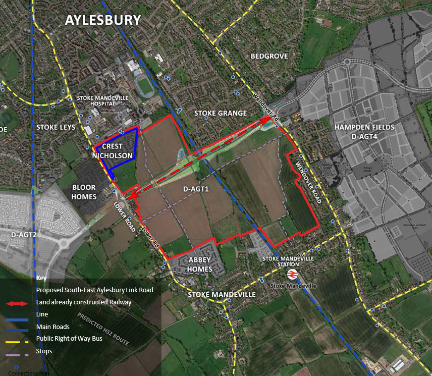
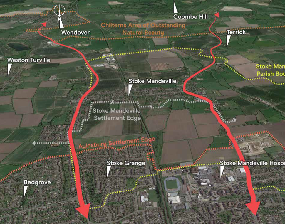
South Aylesbury is in a highly sustainable location, on the southern edge of Aylesbury. Lower Road passes the western edge of the site connecting Aylesbury to Stoke Mandeville. Lower Road provides access to Station Road and Risborough Road and onwards to High Wycombe. Wendover Road passes the eastern edge of the site and also provides access to Station Road.
The AGT1 site is well located to take advantage of a range of sustainable transport options, these include: bus, train and existing pedestrian/cycle routes linking through to Aylesbury in the north and Stoke Mandeville to the south. Public footpaths also cross the site linking Stoke Mandeville Hospital to the north and the adjacent Asda Superstore.
There are a number of existing bus stops in close proximity on both Lower Road and Wendover Road.
The route of the South-East Aylesbury Link Road (SEALR) crosses the site east to west.
Part of AGT1 is already under construction by Crest Nicholson, in the north west corner, and as such is not included as part of the design considerations of this Supplementary Planning Document.
2.2 Site Context
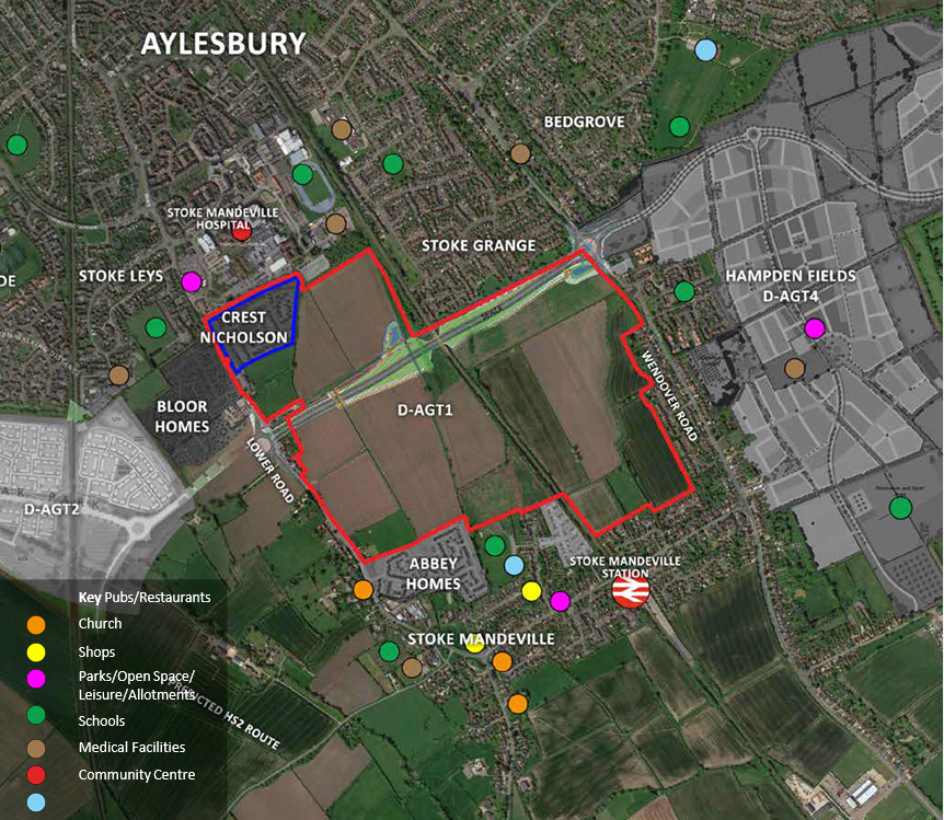
South Aylesbury is well located relative to existing amenities as illustrated on the adjacent diagram. To the north, the Stoke Leys area contains Stoke Mandeville Hospital, a supermarket, Stoke Mandeville Stadium with its sport facilities, and education facilities such as a nursery immediately north of AGT1 and Booker Park School and the Mandeville School.
To the south, Stoke Mandeville village includes the local railway station, a post office and convenience store, local pubs and Stoke Mandeville Primary School,
To the east, the forthcoming AGT4 site will include a number of amenities within its local centre.
2.3 Placemaking Challenges
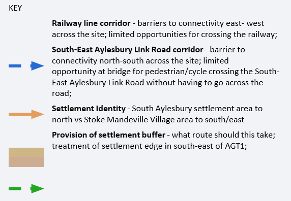
The Vision for AGT1 as outlined in section 1.3 includes the commitment to offer solutions for traversing some of the existing and proposed barriers in the area. This point relates to the railway line that dissects AGT1 on a north to south axis centrally to the site, and the forthcoming South-East Aylesbury Link Road that will link Wendover Road and Lower Road across the northern part of the site on an east to west basis.
One of the objectives of Policy D-AGT1 in the Vale of Aylesbury Local Plan is for the new development to be in accordance with the overarching principles for the development of Aylesbury Garden Town. Commentary on this point is included in section 3.1 of this Supplementary Planning Document. However one of the challenges for AGT1 will be to deliver the design principles of the Garden Town Vision such as Inclusive Design, a connected street layout, and a clear hierarchy of streets and spaces, without letting these 'barriers' reduce the strength of these aspirations.
Another objective of Policy D-AGT1 in the Vale of Aylesbury Local Plan is to incorporate a buffer to maintain the setting and individual identity of Stoke Mandeville village. The routing of this buffer will require careful consideration regarding how it can fulfil this role.
Another challenge to consider is the differing context to the north and south of the AGT1 area; a dense settlement edge to south Aylesbury against a looser context to Stoke Mandeville village to the south. The existing context is considered further in section 2.5.1 of this Supplementary Planning Document.
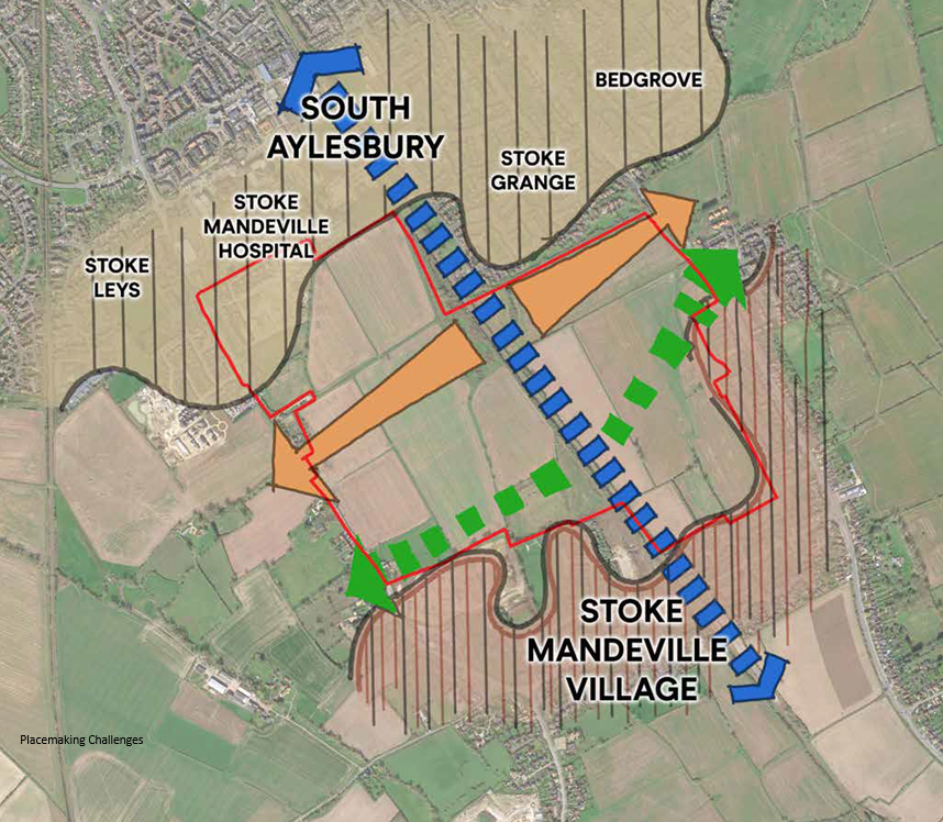
Placemaking Challenges
2.4 Landscape Context
The landscape character of the area in which the South Aylesbury site is located is predominantly influenced by its position within the Vale of Aylesbury, with the nationally important landscape of the Chilterns Area of Outstanding Natural Beauty (AONB) forming the southern valley slopes, and with the town of Aylesbury directly to the north.
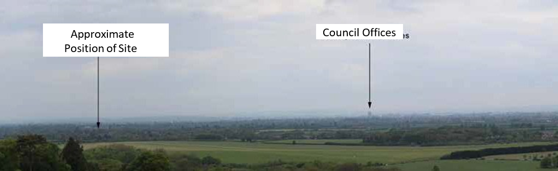
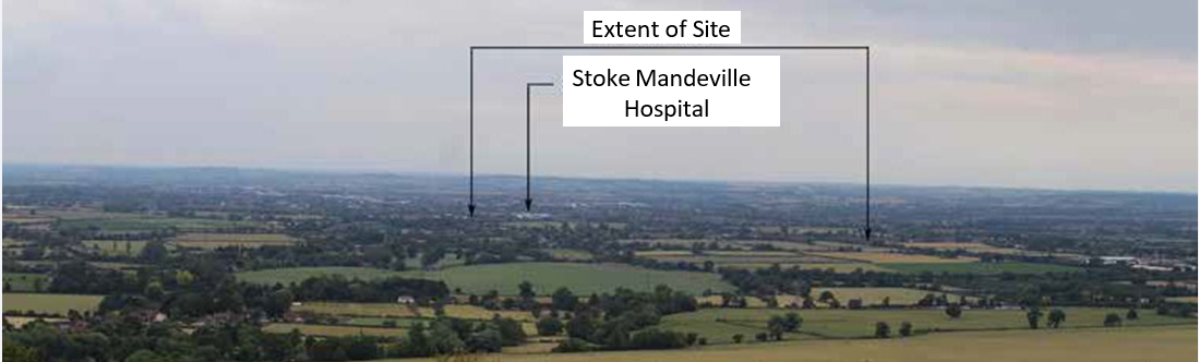
The AGT1 site occupies currently open fields that form the existing gap between the settlements of Aylesbury to the north and Stoke Mandeville to the south and east.
The wider context of the Vale is that of open agricultural land, predominantly arable and punctuated with small to medium-sized villages. To the south, the land rises with a combination of pasture and woodland to the Chiltern Escarpment, from which expansive views over the Vale can be gained, particularly from Coombe Hill.
The Aylesbury Vale Landscape Character Assessment, published in 2008, places the site within the Southern Vale Landscape Character Area, which is associated with the Vale Landscape Character Type. This is broadly described as a "large area of low lying vale landscape with limited topographic variation and containing transport corridors and large villages that due to the open nature and the urban edge of Aylesbury break down the rural character. This is least apparent between the A41 and the Grand Union Canal. The Chilterns to the south are the backdrop to many views."
View from B4009 Upper Icknield Way
View from Monument at Coombe Hill within Chilterns Area of Outstanding Natural Beauty
The published assessment found the overall condition of the Southern Vale to be Poor and its sensitivity to be Moderate. A strategy of landscape restoration and enhancement is therefore recommended, which includes the following guidelines:
- Restore and enhance the original field pattern, where practical.
- Maintain and improve the condition of existing hedgerows through traditional cutting regimes.
- Encourage the planting of new woodland coverts and hedgerow trees, to enhance the landscape structure and screen suburban edges and road corridors.
- Encourage the development of native vegetation in particular black poplar along streams and other watercourses.
- Maintain the condition and extent of neutral grassland.
- Maintain and improve connectivity, particularly of areas of neutral grassland.
- Encourage car-free access to the countryside from Aylesbury and settlements within the Landscape Character Area through the creation of safe routes accessible to the less mobile and cyclists.
Landscape Assessment Plans
2.5 Townscape and Heritage
2.5.1 Townscape
South Aylesbury borders a number of Townscape Character Areas:
- Stoke Leys (including Stoke Mandeville Hospital) to the north- west;
- Stoke Grange (including Elm Farm) to the north-east;
- Stoke Mandeville village to the south and east;
These areas are highly varied and indicative of settlement evolution over time, with each element of townscape being reflective of the era in which it was built. The differing settlement context will require consideration as outlined in Vision and section 2.3 of this Supplementary Planning Document.
The southern suburbs of Aylesbury (Stoke Leys and Stoke Grange) establish the most dominant urban areas around AGT1. Two main routes (Wendover Road and Lower Road) connect Aylesbury with the villages and settlements to the south which are characterised by their linear and historic development and evolution along these routes.
Stoke Leys
The southern edge of Stoke Leys is urban in form with large buildings within the Stoke Mandeville Hospital complex and large areas of parking. Within this development area is Stadium Approach and a large amount of high density residential development up to three and four storeys in height.
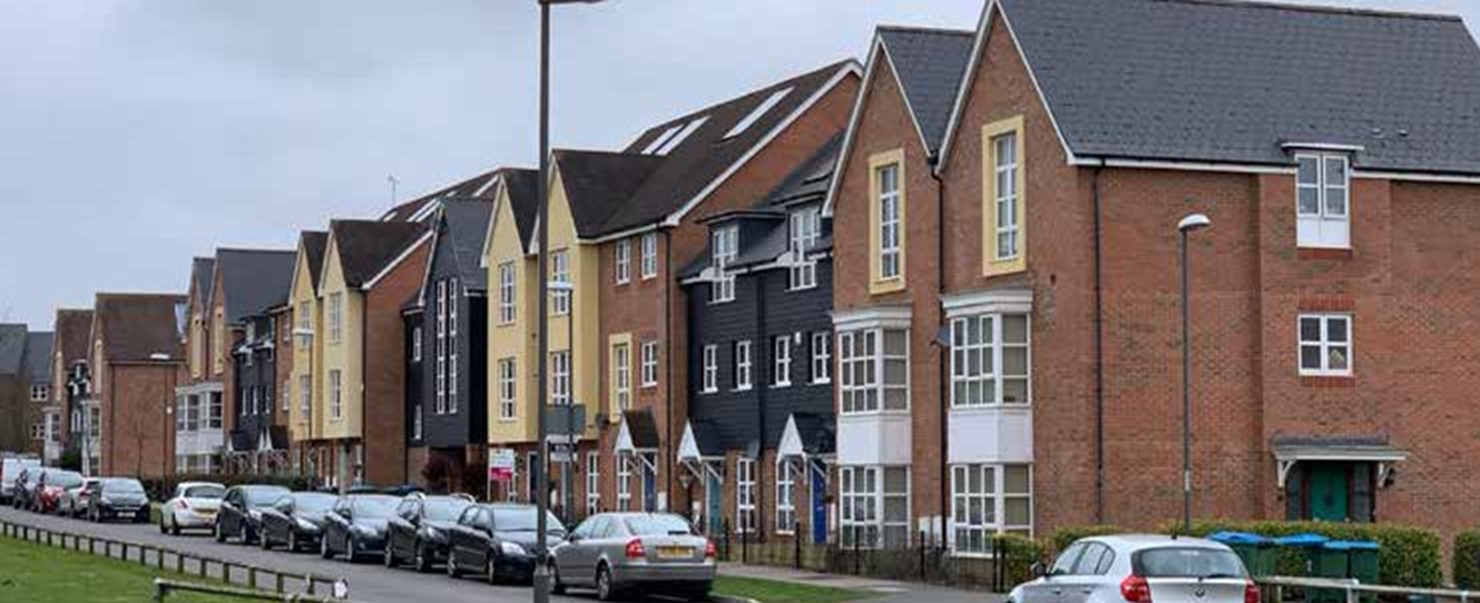
Higher density housing around Stadium Approach
Stoke Grange
The southern edge of Stoke Grange is more domestic with outwardly facing housing areas onto a stronger landscape boundary. There is a varied typology of houses and density, with low density to the east adjacent to Wendover Road, increasing to a higher density including maisonettes adjacent to the railway.
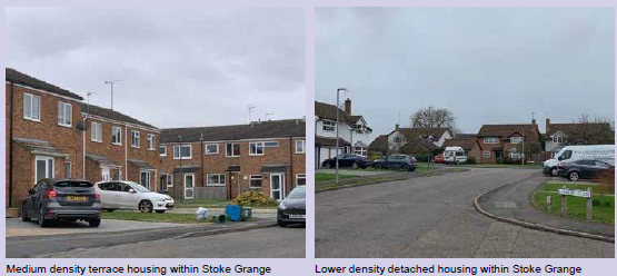
Medium density terrace housing within Stoke Grange and Lower density detached housing within Stoke Grange
Stoke Mandeville
Stoke Mandeville has evolved into a linear settlement along Station Road, and whilst initially separate from Aylesbury, there is only a small gap between the settlements along Wendover Road to the east. A more convincing buffer from Aylesbury is maintained to the south-west along Lower Road. Stoke Mandeville retains a partially rural character in its centre. Its northern edges, closest to the AGT1 site, are characterised by a feathered edge west of the railway line reflecting the most recent development areas which are in general outwardly facing, whereas east of the railway line a harder edge is formed due to piecemeal developments backing onto the AGT1 site. The density of these areas are generally low to medium, with a mixture of detached and semi- detached houses.
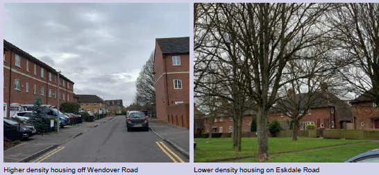
Higher density housing off Wendover Road and Lower density housing on Eskdale Road
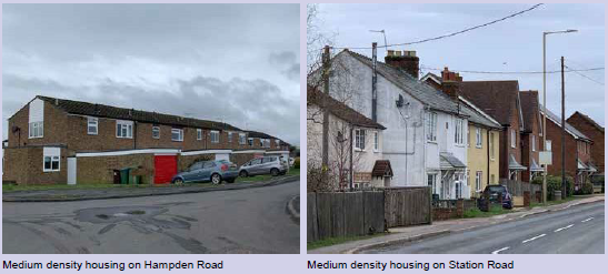
Medium density housing on Hampden Road and Medium density housing on Station Road
2.5.2 Heritage
The nearest conservation area to South Aylesbury is located within the village of Weston Turville, which is separated from the site by the existing settlement of Stoke Mandeville.
There is one listed building within the AGT1 site, being the Grade II Listed Magpie Cottage which lies directly adjacent to Lower Road in the south-west corner of the site. There are a number of other Listed Buildings within the wider area, however given the strong level of containment afforded to the AGT1 site by adjacent structures, the only Listed Buildings that will require consideration of their setting through the proposed development are Magpie Cottage, Stoke Cottage and Lone Ash. Green buffers should be provided to separate adjacent listed buildings from the new development.
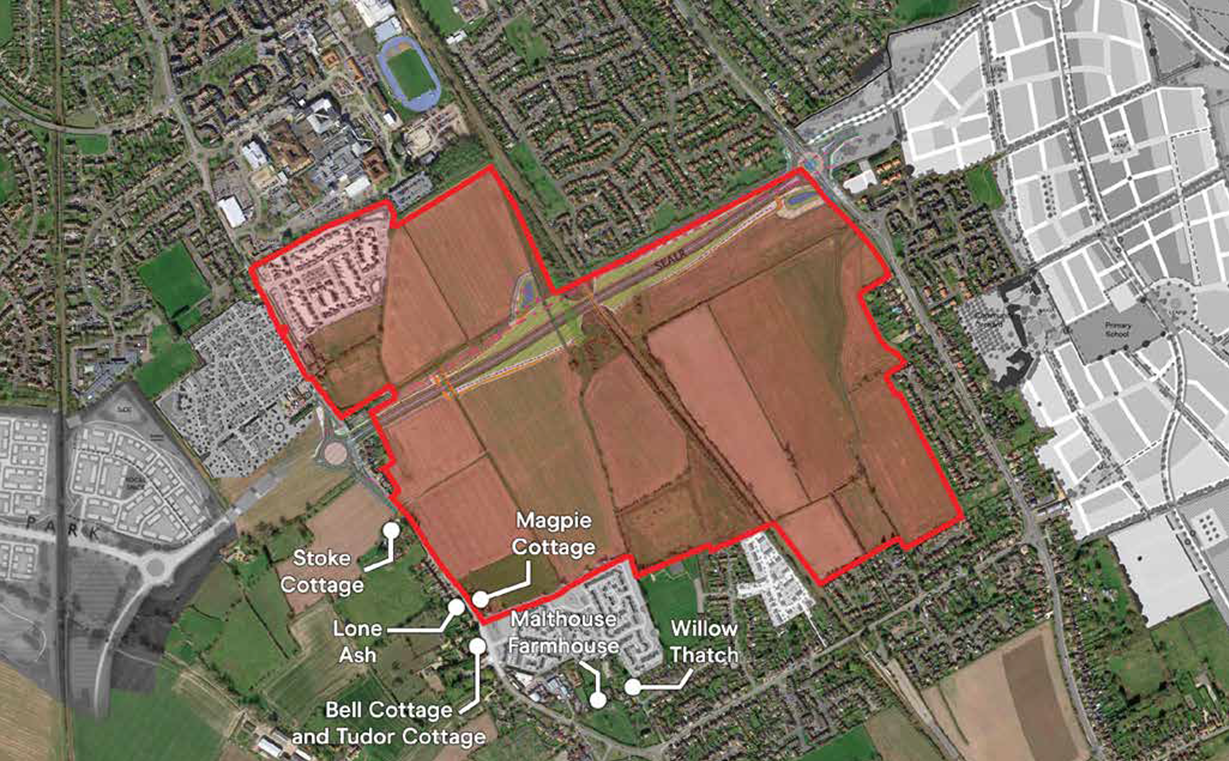
Listed Buildings
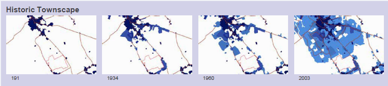
Historic Townscape Development
2.5.3 Archaeology
Across the wider landscape, to the south of Aylesbury, a number of Archaeological Notification Areas have been identified, two of which lie within the AGT1 site boundary (SMR No 54950 and 61860). Historically, the AGT1 site has been subject to a series of archaeological investigations and surveys, including a fieldwalking survey in 1998, which identified evidence for historic activity in the area dating from the Mesolithic period (9600 - 4000 BC) through to the Post-Medieval period (1540 – 1901 AD). A detailed desk based assessment undertaken by Thames-Valley Archaeological services, identified a significant number of non-designated heritage assets within a 500m study area of the AGT1 site. Historic activity was further confirmed by geophysical and evaluation works in 2015, undertaken by Phase Site Investigations in the north-eastern corner of AGT1.
Archaeological remains present within the site boundary include settlement activity and inhumations of Bronze Age (2600 BC - 700 BC) and Romano - British (43 AD to 410 AD) date. Evidence for Medieval (1066 AD – 1540 AD) and Post-medieval agricultural activity in the form of ridge and furrow has also been recorded across the site. To the west of the railway line Bronze Age remains have been identified and there is a high potential that associated remains of this period extend further east.
On both sides of the railway line and within the site boundary, Romano - British features such as ditches and inhumation burials were recorded during evaluation excavations in 1995 by Wessex Archaeology. Therefore, it is reasonable to assume that there is a high potential for remains to be present on site, which would contribute to the understanding of Roman rural settlement within this part of the Vale of Aylesbury. Medieval and Post-medieval remains are also likely to be present on site in the form of ridge and furrow but the presence of further finds and features, dating to these periods, cannot be ruled out.
Due to the high archaeological potential within the site, any groundworks associated with development are likely to significantly disturb, destroy or truncate buried deposits dating to almost any period. An effective mitigation strategy of evaluation, for example, through geophysics and trial trenching, should be developed in consultation with the Archaeology Officer, Planning, Growth and Sustainability at Buckinghamshire Council, at the planning stage of development.
The evidence to-date shows no reason that the development within the AGT1 site cannot take place, however, undertaking a mitigation strategy will best preserve and mitigate any potential impact to known and hitherto unknown buried archaeological deposits within the AGT1 area.
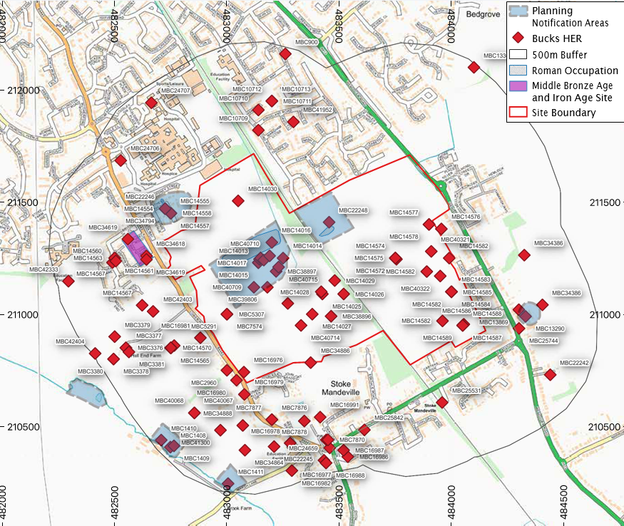
Archaeological Survey of the Site
2.6 Land Ownership
South Aylesbury is controlled by several different land ownerships / parties, these are identified on the adjacent plan. Buckinghamshire Council have worked together with the four Principle Parties (Lands Improvement, CALA, Vanderbilt Strategic and Redrow) to produce this Supplementary Planning Document in a collaborative fashion to ensure a cohesive and co-ordinated approach to development of the allocation as a whole.
This Supplementary Planning Document provides a strategic context to allow landowners / controlling parties to submit a planning application(s), whilst ensuring a comprehensive and cohesive development is delivered. In the event a single planning application is not submitted which would otherwise ensure the comprehensive development of the site, then multiple applications could be considered provided that an appropriate delivery mechanism is assured, as set out in outline Chapter 5.
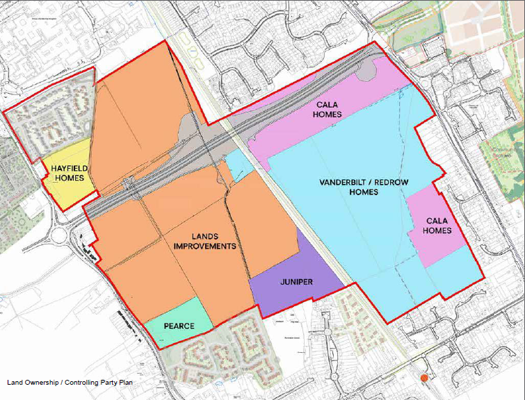
Land Ownership / Controlling Party Plan
2.7 AGT1 Site - Existing Features, Topography and Ecology
2.7.1 Existing Features
South Aylesbury is divided by the north-south alignment of the London Marylebone to Aylesbury Vale Parkway railway line. The railway is at a similar level as the site, and is fairly well screened by existing vegetation on either side. Away from this, the rest of the site consists of a number of fields, many of which are divided by strong existing hedgerow features which also form the routing of an existing network of public footpaths crossing the site. The east-west route across AGT1 is connected by a level crossing over the railway.
The AGT1 site is generally flat across its entirety, with very gentle falls towards a watercourse in the western half of the site running along the central north-south field boundary on the eastern half of the site.
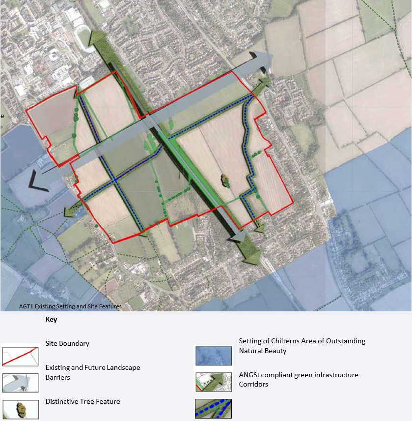
AGT1 Existing Setting and Site Features
2.7.2 Ecology
The main constraints are the ecological value of the existing hedgerows, trees and in particularly two black poplar trees located on the eastern side of the railway line.
A wintering bird survey of the land has identified that the area is used by relatively low numbers of bird species typically associated with farmland, woodland edge and garden habitats. Although some of the bird species recorded are included on the Birds of Conservation Concern 'Red' and Amber' lists, these generally relate to common and widespread, albeit declining, species such as Song Thrush, Starling, Skylark and Yellowhammer. No large flocks of wintering waders such as Lapwing or Golden Plover were recorded. Suitable mitigation for impacted habitats should be identified and provided part of the application process.
Any scheme for development will aim to retain the existing hedgerows where appropriate and / or provide enhancement through improved connectivity and ANGSt compliant green infrastructure. Loss of hedgerow would require compensation.
Development on South Aylesbury should provide a net gain in biodiversity, which will be assessed by detailed reports submitted at planning application stage. The net gain in Biodiversity, which is required through VALP Policy NE1, will protect, manage, enhance and extend existing biodiversity resources through habitat creation / improvement such as grassland, scrub, woodland and hedgerow
2.8 Drainage and Flood Risk
The railway line divides the site into two distinct hydrological areas. Land to the East drains to the Bedgrove Brook and land to the west drains to the Southcourt Brook. The Aylesbury Vale Strategic Flood Risk Assessment (SFRA) presents the outputs of broadscale modelling which shows parts of the site to be at risk of flooding from surface water and fluvial flooding associated with the existing channels on site. Site-specific modelling has been carried out to refine the understanding of flood risk as discussed below;
East Area
Within the eastern parcel the mapped flood risk is predominantly associated with the Bedgrove Brook. The majority of the flows arise from the urban areas to the south and east and discharge to the Bedgrove Brook via piped connections.
Hydraulic modelling work reveals that culverts on the site and under Wendover Road cause shallow flooding of the site during extreme events and present a residual risk should a blockage occur. Agricultural crossings should be removed as part of the development. It will also be necessary to raise some land in the northern part of the site to secure safe access and to deliver the AGT1 proposals.
Options modelling demonstrates that creating additional storage alongside the Bedgrove Brook to the south is a feasible strategy for mitigating flood risk. This presents an opportunity to enhance the ecological and landscape value of the channel corridor which should be explored as part of any planning application.
West Area
The Southcourt Brook flows on the eastern side of the western parcel and two field drainage ditches are present within the allocation along field boundaries. These features predominantly receive diffuse runoff from the surrounding undeveloped land. The risk from these watercourses has therefore been assessed using a direct rainfall approach which provides a robust assessment of flood risk.
Flooding during extreme events is generally constrained to locations adjacent to the existing ditch network and localised depressions. The modelling also highlights a potential for surface water to enter the site from Lower Road. Modelling of the proposed development and surface water drainage concludes that the site's surface water drainage would reduce flows within the ditches, providing a reduction in flooding both on the site and beyond the site.
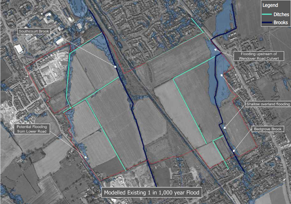
The Strategic Flood Risk Assessment mapping also indicates that part of the site is potentially susceptible to groundwater flooding. A review of the hydrology, topography and available geology data concludes the risk is very low, but it should be considered in more detail as site proposals are brought forward and suitable mitigation identified.
Built development should be avoided in areas shown to be at risk from a 1 in 1,000 year event following mitigation works. Hydraulic modelling will be required to demonstrate that development proposals will not increase flood risk elsewhere.
The AGT-1 policy sets out requirements for drainage, flooding and associated infrastructure which will require consideration by forthcoming planning applications.
2.9 Current and Future Development of South Aylesbury
A key consideration for the development of South Aylesbury is the new South-East Aylesbury Link Road (SEALR) which will cross the AGT1 site on an east to west basis in the northern part of the site, connecting new roundabouts on Lower Road and Wendover Road.
The central section of the South-East Aylesbury Link Road as it crosses AGT1 will be raised to pass over the railway line, and as such new embankments will be formed sloping down to the existing ground level. On the western side of the railway, an underpass route will be included allowing for pedestrian and cycle movement north-south through the AGT1 site. This is part of an aspirational route connecting Stoke Mandeville Station to the south with Stoke Mandeville Stadium to the north - much of this route will be through South Aylesbury.
Around the edges of the site are a number of new residential development areas;
- Northwest- Crest Nicholson (part of overall AGT1 area) and Bloor Homes developments off Lower Road;
- South-west- Abbey Homes development off Lower Road;
- South- Ridgepoint Homes development off Eskdale Road.
Also to note are the other Garden Town extension sites adjacent to AGT1:
- AGT2- located west of Lower Road
- AGT4- located east of Wendover Road
Both of these sites have similarities to AGT1 by dealing with strategic buffers, the Gardenway and strategic link roads.
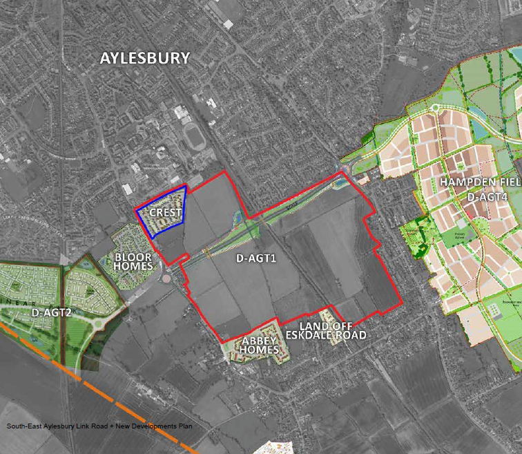
South-East Aylesbury Link Road + New Developments Plan
2.10 AGT1 Site Specific Considerations
Combining the technical baseline information as highlighted over the preceding pages forms an overarching constraints plan for the AGT1 site. This plan should be used as a basis for the development of concept ideas and framework layout plans for the site.
The constraints plan also refers to the contextual studies of the wider area at the beginning of this chapter which will inform the positioning of various infrastructure elements as required in South Aylesbury.
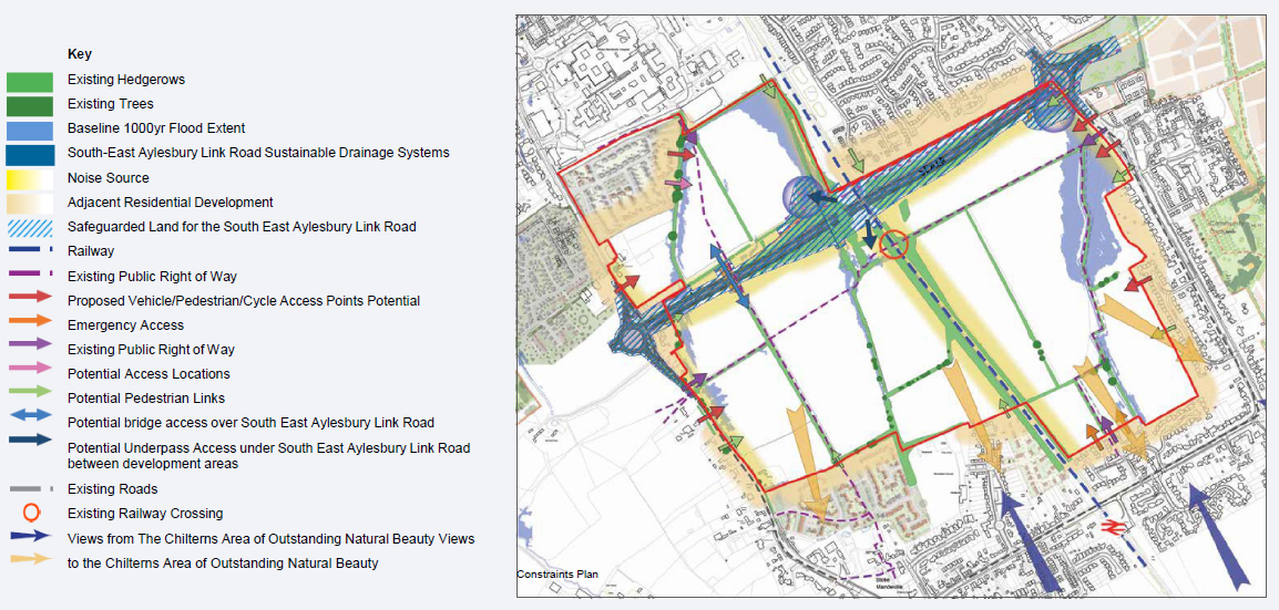
Constraints Plan
2.11 Design Response & Opportunities
Alongside the consideration of technical constraints a strategy to outline key design opportunities has been reviewed, and in doing so respond to the challenges outlined in section 2.3. These opportunities should also reflect the Vision aspirations as set out in section 1.3
- Landscape framework – the site has a strong network of hedgerows and trees which can establish a framework of green corridors and spaces that should form the basis of placemaking around the site
- Functional Connectivity – the aspiration to strengthen connections between south Aylesbury and Stoke Mandeville can be incorporated through enhancement and additions to the existing public routes that cross the site
- Barrier crossings – specific locations to cross the railway line and South-East Aylesbury Link Road are identified – these could be split between options that can be delivered in the short term and options for future connections
- Visual Buffer – the route of the potential landscape buffer has provides the opportunity to link the 'gaps' in between existing settlement areas on the east and west edges of AGT1;
- Settlement Identity – potential development areas can relate to the context to which they are closely related; northern area being south Aylesbury and southern area to Stoke Mandeville village. The central areas can be transitional and adopt a stronger theme/character that distinguishes AGT1 as a new Garden Town neighbourhood.
- Locations of 'centres' to development area – where other uses could be located and where housing densities could be increased.
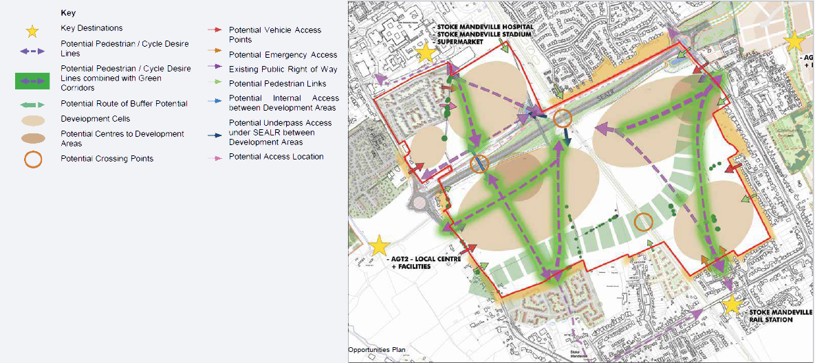
Opportunities Plan


