AGT1 Supplementary Planning Document
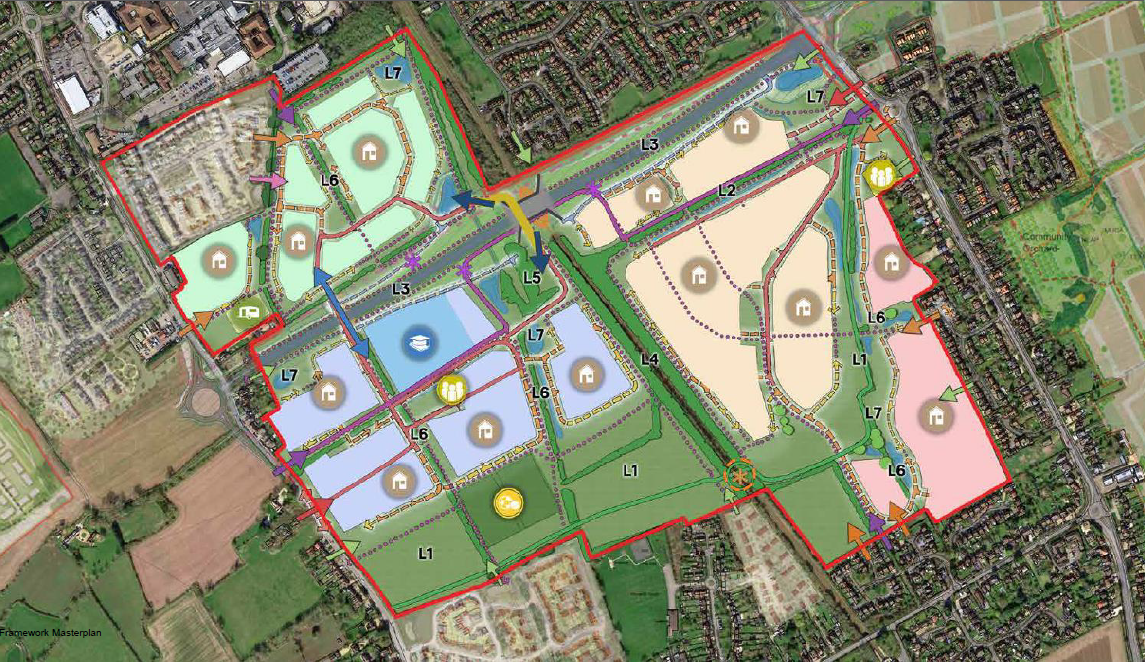
4.1 Framework Masterplan
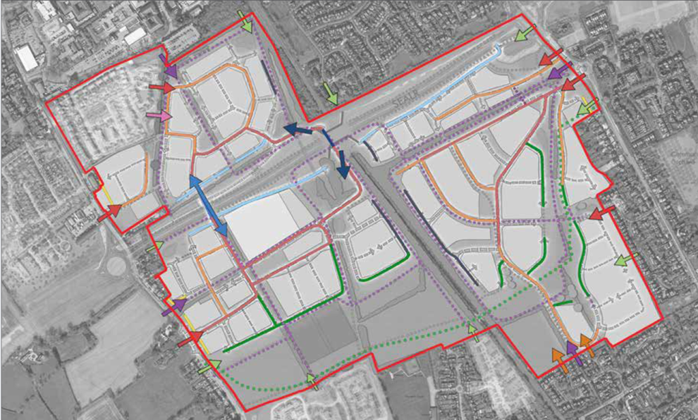
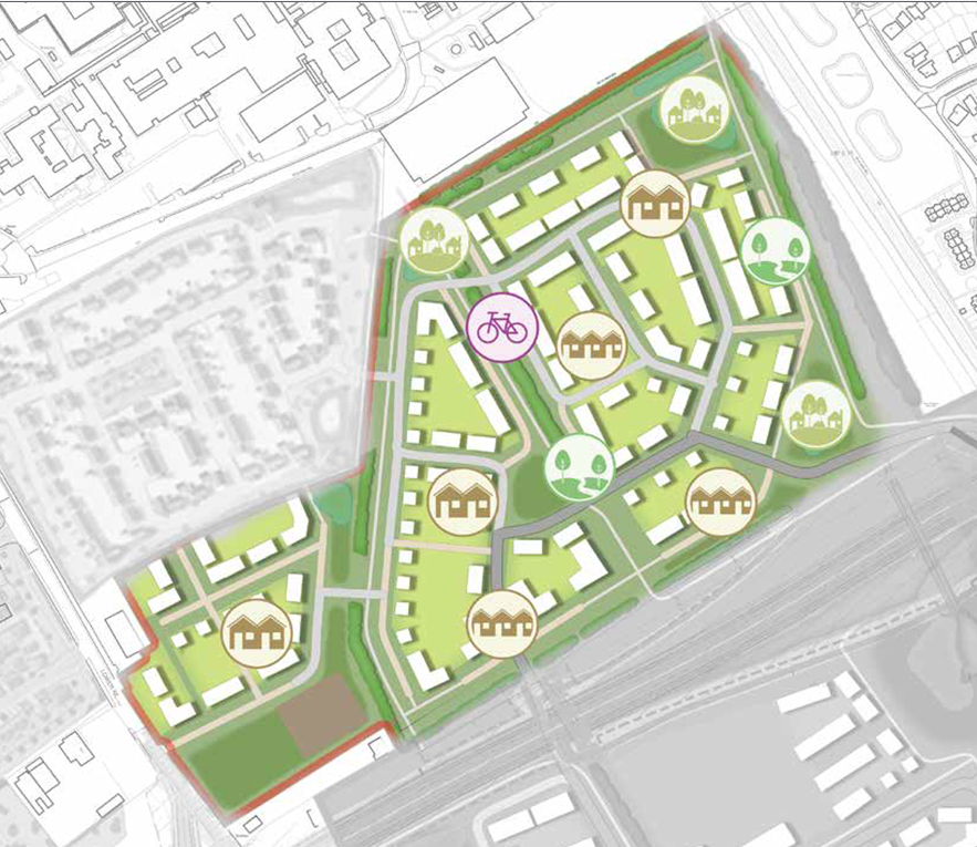
The context analysis and conceptual layering illustrated through sections 2 & 3 of this document have informed the production of a Framework Masterplan for the AGT1 site. The Framework Masterplan illustrates the following:
- Landscape and ANGSt compliant green infrastructure – strategic spaces, green corridors, open spaces, infrastructure buffers;
- Access and Movement – potential vehicle and pedestrian/cycle access locations, movement framework, 'barrier' crossing options;
- Development Area and Character– character and identity, urban design principles, density and massing;
- Land Uses and infrastructure – potential locations for infrastructure delivery and facilities;
The contents of Section 4 have been aligned with the Framework Masterplan content and as such the following pages are grouped under the headings above. Each section provides an overview of the parameters that may influence the design of the specific element, and guidance and examples of how good design could be achieved.
Framework Masterplan
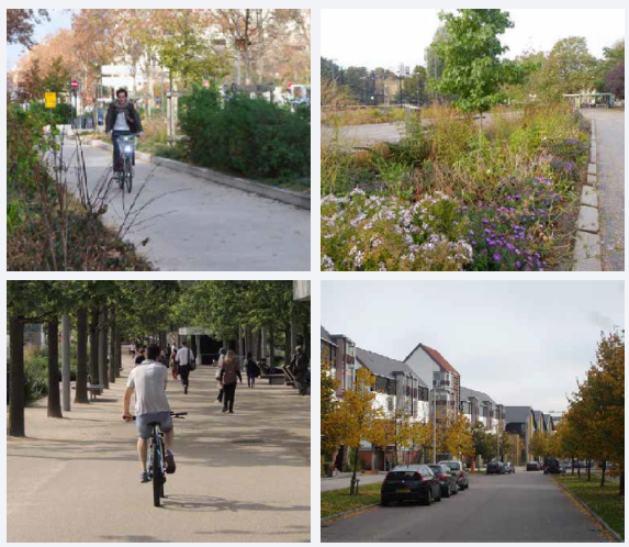
4.2 Landscape, ANGSt compliant green infrastructure / Blue
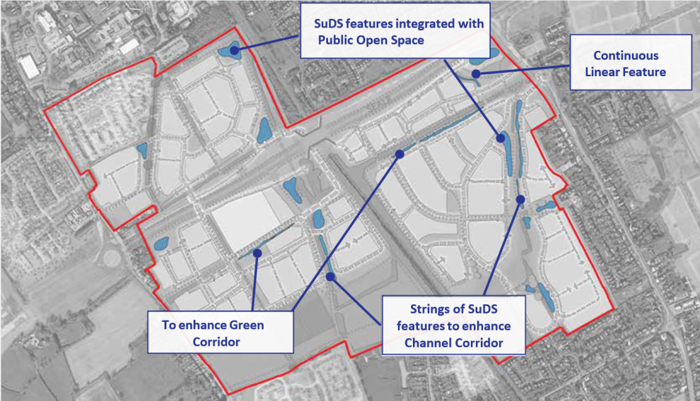
An overarching Green and Blue Infrastructure plan has been developed for AGT1, which will form the basis for forthcoming designs of each area. Within this the landscape areas have been characterised to set out their differing typologies and design principles. Given the integrated nature of green and blue infrastructure within the scheme, the majority of the typologies below represent both kinds to some degree.
Green and Blue Infrastructure Typology Principles
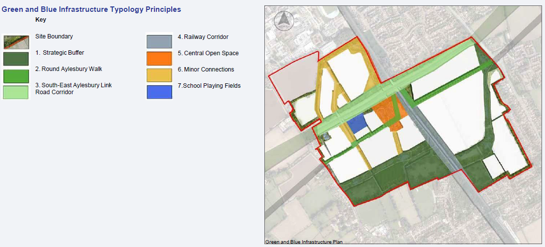
Green and Blue Infrastructure Plan
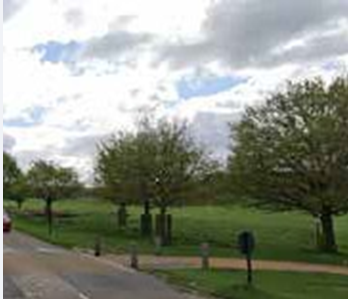
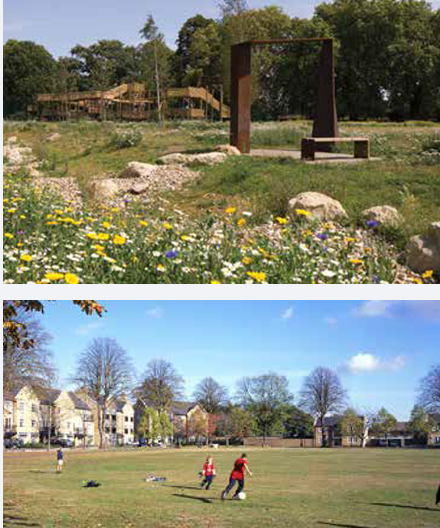
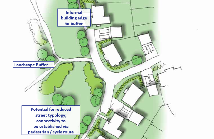
4.2.1 Strategic Buffer
This will be a substantial swathe of public open space and retained agricultural land that will preserve the separate identity of Stoke Mandeville village, whilst providing an attractive resource for its residents. It is also possible that this will support the Aylesbury Gardenway in the future.
It will be designed in accordance with the following principles:
- Mix of landscape treatments, with carefully designed transition to avoid abrupt change.
- Non-agricultural areas to be accessible, including provision of all-ability access.
- Surfaced access routes to be provided in line with Aylesbury Gardenway design principles, to support potential future alignment.
- Land to be reserved for future provision of Aylesbury Gardenway additional railway crossing.
- Water to be a unifying theme, including watercourses along its length and ponds providing additional interest.
- Woodland and tree planting to be used to achieve effective visual separation of the settlement areas.
- Design to consider public safety and signposting to give confidence to users.
- Combination of amenity grassland and meadow areas to balance public recreation with ecological habitat and seasonal diversity.
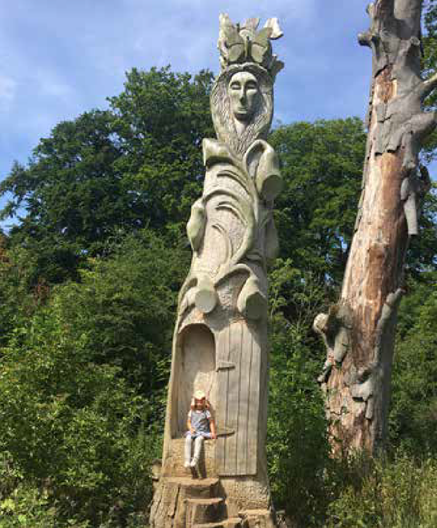
- Play to be subtly incorporated within the area and not limited to fenced areas, through the use of naturalistic features such as clamber art, land art (e.g. mown labyrinths), and water play.
- Species mixes to be predominantly native and reflective of the prevailing character and soil type, with a 10% proportion of climate-proof species and provenances.
- Additional pitches to school provision, as per Policy I2 requirements. Pitches located in close proximity to existing recreational use to the south to enhance use and connection between AGT1 and Stoke Mandeville.
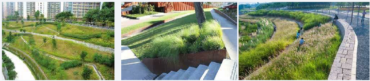
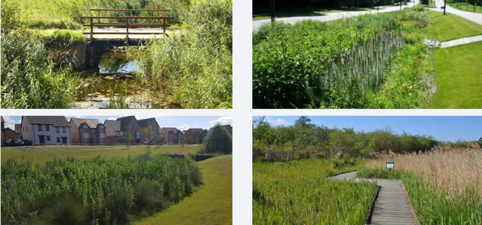
Biodiversity led landscape
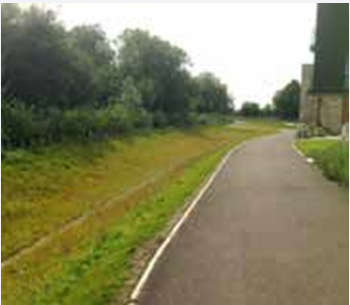
Footpath/Cycleway and Swale
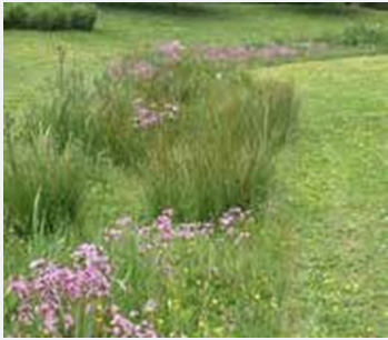
Swale Linear Wetland Habitat
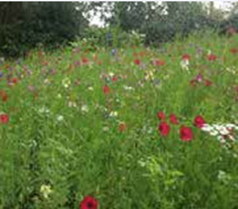
Wildflower Meadows
Wildflower Meadows
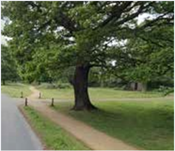
Path/Road Crossing
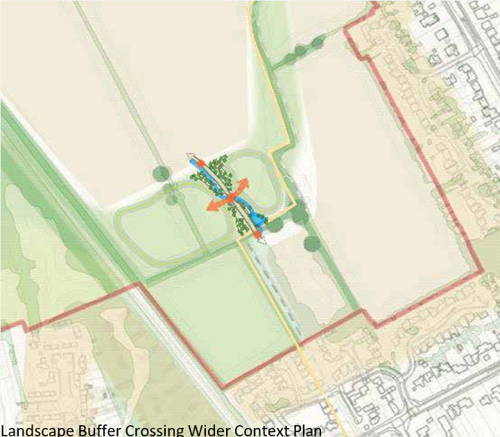
Landscape Buffer Crossing Wider Context Plan
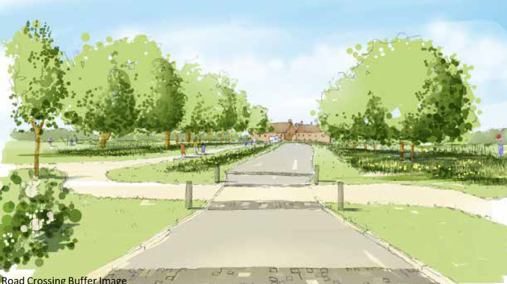
Road Crossing Buffer Image
4.2.2 Round Aylesbury Walk
This will be a green boulevard crossing the development on the approximate alignment of the existing Long Distance Recreational Route. It will be a wide urban street with strong ANGSt compliant green infrastructure, such as street trees, rain gardens and meadow verges, and it will include provision to possibly support the alignment of the Aylesbury Gardenway. It will utilise the proposed South-East Aylesbury Link Road crossing over the main line railway to provide a sustainable connection through the site between Lower Road and Wendover Road. The Round Aylesbury Walk is a historic route separate to the Proposed Gardenway.
It will be designed in accordance with the following principles:
- Wide, high quality urban boulevard that reflects the latest positive street design principles.
- Use of ANGSt compliant green infrastructure elements such as street trees, rain gardens and meadow verges to deliver social and environmental value.
- Inclusion of places to pause, meet and congregate, in association with trees to take advantage of natural shade and shelter.
- Strong presence of street trees to contribute to overall urban tree canopy when viewed from Coombe Hill.
- Inclusion of open water features for positive sensory input and sustainable drainage.
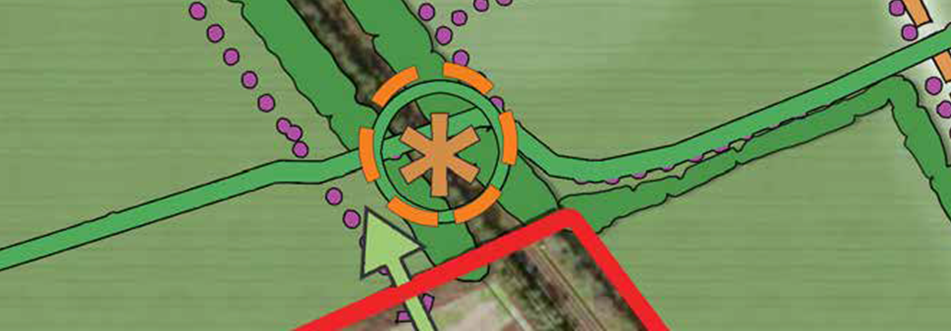
4.2.3 South-East Aylesbury Link Road Corridor
Whilst the primary aim of this area will be to support a strategic access route, the verge and embankment areas are substantial and have the potential to deliver ANGSt compliant green infrastructure value. In addition, given the level of elevation of the proposed embankment, it is important to respond positively to the visual relationship with the Chilterns Area of Outstanding Natural Beauty to the south, and in particular the nationally important view from Coombe Hill.
It will be designed in accordance with the following principles:
- Use of naturalistic rough grassland and woodland to soften the appearance of embankments and maximise biodiversity value and seasonal interest.
- Setting of routes over the embankment within meadow grassland corridors to enable long visibility and for visual interest.
- Seeking the inclusion of a viewing point at the top of the southern face of the embankment to enable the backdrop of the Chiltern Escarpment to be appreciated.
- South-East Aylesbury Link Road Bridge – the proposed bridge carrying the new South-East Aylesbury Link Road (application CC/0015/20) over the railway has been approved which includes a segregated pedestrian/cycle route set away from the road. As such this should be utilised as a way of crossing the railway for people walking and cycling and links to this crossing should be established to the AGT1 development. Each point of access should conform to the following principles:
- Be usable by all pedestrians and cyclists, in that ramps should be at an appropriate gradient, and be minimised to ensure the ease of movement from the site level up to the bridge is considered;
- These ramps should be well lit and overlooked as much as possible by the new development within AGT1. Therefore buildings closest to the ramps should have frontage and habitable windows overlooking these spaces;
- The routes should link with the wider movement framework through AGT1 to ensure direct movement is promoted, and use of non-vehicular forms of transport.
- The ramps can be used as a design feature in the landscape treatment of the embankment, with potential layering of soft and hard landscape design used to provide interest for users.
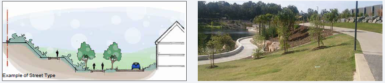
Example of Street Type
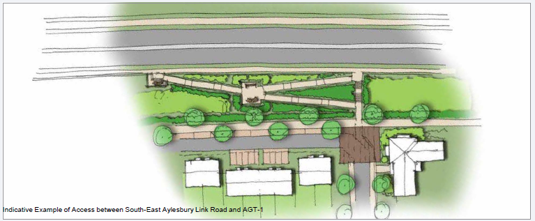
Indicative Example of Access between South-East Aylesbury Link Road and AGT-1
4.2.4 Railway Corridor
This area represents the flanks of the railway line, which support scrubby woodland vegetation and therefore provide ANGSt compliant green infrastructure connections through the site, as well as visual screening of the railway line.
It will be designed in accordance with the following principles:
- Retention of scrubby woodland habitat areas and protection through construction process.
- Creation of narrow belts of complementary habitat within the AGT1 site in association with public movement routes.
- Working with Network Rail to seek to manage these areas to retain and enhance their ecological value, e.g. through periodic coppicing to maintain dense, scrubby character.
4.2.5 Central Open Space
This will be an area of naturalistic informal open space within the centre of the site, close to the proposed railway crossing. It will provide an attractive place for people to come together, with a central area of close-mown grassland for informal play, and with areas of open water. Being located at the end of the Green Boulevard on the western side of the site, it also has the potential to host local community events.
The central location of this space allows for good accessibility from the other development areas within AGT1. As such the design of the space should allow for differing movement routes to be accommodated once further detail work has been conducted on the appropriate access proposals to the other development areas. The space should be well overlooked, with development frontage around at least two sides, ensuring a space that is safe to use and move through at any time of day or night.
It will be designed in accordance with the following principles:
- Naturalistic space supporting a combination of native woody vegetation, meadow grassland, amenity grassland and open water.
- All non-water areas to be fully accessible to the public, with ground vegetation managed to facilitate this.
- Existing vegetation to be retained where possible, and rejuvenated through coppicing and pruning.
- Paths to provide all-ability access, linking in with Green Boulevard.
- Inclusion of picnic benches to facilitate opportunities for community cohesion and family use.
- Inclusion of naturalistic play features (boulders, logs, mounds, etc) to encourage imaginative play, possibly including sculptural elements.
4.2.6 Minor Connections
This represents a number of smaller connections through the site, which are likely to provide ANGSt compliant green infrastructure value at a neighbourhood scale. They are principally based upon local sustainable movement routes, although it will be important for them to deliver a range of environmental services to fulfil their ANGSt compliant green infrastructure potential.
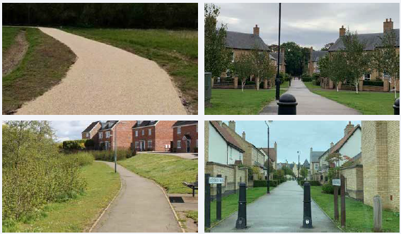
These routes will be designed in accordance with the following principles:
- Surfaced routes providing all-ability sustainable access (walking and cycling), all year round.
- Signposting giving walking and cycling distances to key locations, to encourage use.
- Naturalistic features such as hedgerows and swales along the routes to provide wildlife connectivity and habitat, seasonal interest and other environmental services.
- Sufficient width of corridors to accommodate movement routes and natural features, whilst conveying a sense of space and security.
- Positive relationship with adjacent urban edges, with properties presenting active frontages, not rear garden boundaries.
4.2.7 School Playing Fields
This represents an area of playing fields associated with a new primary school within the development, but which have the potential to be made available out of hours to the wider community.
The playing fields will be designed in accordance with the following principles:
- Inclusion of native hedgerows on the boundaries of the playing fields, for natural security and wildlife connectivity.
- Inclusion of hedgerow trees on the boundaries of the playing fields, to provide natural shade and shelter, and to improve wildlife value.
4.2.8 Surface Water Drainage
The site is shown by British Geological Society data to be underlain by a mixture of Mudstone, Siltstone and Sandstone. Local borehole records show groundwater levels to be relatively close to the surface. At this stage it has been presumed that it will not be possible to manage site surface water using infiltration techniques. Site investigation works should be carried out to determine the specific conditions on site to support any detailed planning application in accordance with Lead Local Flood Authority guidance.
It has therefore been assumed that surface water is managed using a store-and-release approach and discharging to the existing channels within the site. Given the sensitivity of the urban areas downstream of AGT1, surface water discharge should be attenuated to the existing 1 in 2 year runoff rate of 3.3l/s/ha, this will reduce flooding downstream as far as is reasonably practicable.
In order to deliver the vision for AGT1 as part of the Aylesbury Garden Town, it is considered essential that water is managed using vegetated above ground Sustainable Drainage Systems (SuDS).
The likely location of strategic storage features has been derived taking consideration of the development proposals, existing topography and assuming a design storage depth of 1m and an additional 0.3m of freeboard.
It is envisaged that these features will take a variety of forms depending on their location, varying from ecological driven designs with permanent standing water (for example alongside the railway line), through naturalized designs that remain dry in a 1 in 10 year event and provide valuable open space, to formal hard-landscaped features within the higher density parts of the development.
Proposals for Sustainable Drainage Systems should be considered from the outset for any development proposals brought forward for planning in order to maximise water quality, quantity, biodiversity and amenity benefits. The potential for integrating open conveyance features within the development rather than relying on a piped solution should be considered, especially in flatter parts of the site where a conventional solution would necessitate significant development plot raising. Specific consideration should be given to using Sustainable Drainage System features and modification of the existing drainage channels to create distinctive blue corridors.
Site design should seek to deliver Sustainable Drainage System features such as rainwater harvesting, grey water systems, and rain gardens along with maximising the use of permeable surfacing to provide further benefits.
Foul Water Drainage and Potable Water Supply
There are existing foul water sewers crossing the site which should allow for gravity drainage of the site's foul water. Trunk water mains are present under Wendover Road and in the northern part of the site.
Indicative Sustainable Drainage Systems Plan
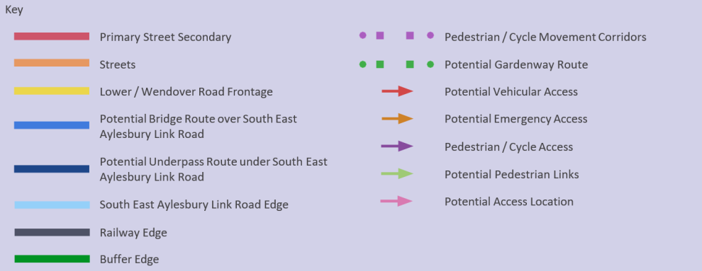
4.3 Access and Movement
4.3.1 Street and Movement Hierarchy
The movement framework has been developed in the context of the key N-S and E-W linkages on either side of the railway line taking into account constraints such as the South-East Aylesbury Link Road. Where the N-S/E-W linkages converge this provides a natural location for activity in the form of local centre (café, shop, the Third Place) and school (where activity is forecast to be greatest) and also the provision of Mobility hubs to enhance access to travel choice.
In terms of the network of streets throughout the site, then this will comprise at least three levels of hierarchy (as per the principles within Manual for Streets) from the primary road into the site from Lower Rd / Wendover Rd respectively and then Secondary and Tertiary roads (not shown on this plan). Whilst the primary road will naturally provide greater priority in terms of vehicle movements, the landscape strategy and movement strategy for pedestrians / cyclists should dictate the character / cross section of the road, rather than the vehicle movement itself. At Tertiary street level, and depending on the attitude towards car parking provision (it could be zero), the streets should be designed with greater emphasis on space for pedestrians/cyclists and a reduction in parking standards.
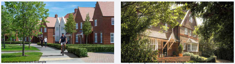
The Transport Strategy for AGT1 is predicated on taking advantage of the locational benefits and of the site relative to local amenities such as employment, retail, Aylesbury town centre and Stoke Mandeville train station and through informed masterplan design to maximise the potential for the internalisation of trips. It is based on the Garden Town Principles and National Transport Policy relating to mobility and sustainability, encouraging travel choice and trips made by foot/cycle (local topography is flat and conducive), public transport and reducing car use. The strategy will be made of numerous movement components including commuting and recreational cycle routes, bike hire, mobility hubs, demand responsive buses and personalised travel planning.
The Framework Masterplan sets out a potential movement framework that could be adopted in forthcoming designs. Key to this is the pedestrian and cycle movement across AGT1 which should be placed as the highest priority in terms of layout design for direct access, and treatment at junctions in terms of priorities over roads.
The Movement Framework plan sets out the potential hierarchy of routes, and these can be characterised as follows:
Indicative Movement Hierarchy
|
Area1 |
Area2 |
Area3 |
Area4 |
||
|
Access |
|||||
|
Primary |
Yes |
Yes |
Yes |
No | |
|
Secondary |
Yes |
Yes |
Yes |
Yes |
|
|
Pedestrian / Cycle Access |
Yes |
Yes |
Yes |
Yes |
|
|
Routes/Edges |
|||||
|
Primary Movement Corridor |
Yes |
Yes |
Yes |
No | |
|
Secondary Streets |
Yes |
Yes |
Yes |
Yes |
|
|
Lower / Wendover Road Frontage |
Yes |
Yes |
Yes |
No | |
|
South-East Aylesbury Link Road Edge |
Yes |
Yes |
Yes |
No | |
|
Railway Edge |
Yes |
Yes |
Yes |
No | |
|
Buffer Edge |
No |
Yes |
Yes |
Yes | |
|
Courtyard Space |
Yes | Yes | Yes | No | |
|
Private Drive |
Yes | Yes | Yes | Yes | |
|
Residential Edge |
Yes | No | No | Yes | |
|
Pedestrian / Cycle Routes |
Yes | Yes | Yes | Yes | |
|
Infrastructure |
|||||
|
Central Mobility Hub |
No | Yes | Yes | No | |
|
Minor Mobility Hub |
Yes | Yes | No | Yes | |
Movement Hierarchy Matrix
4.3.2 Street Types
|
Street Type |
|
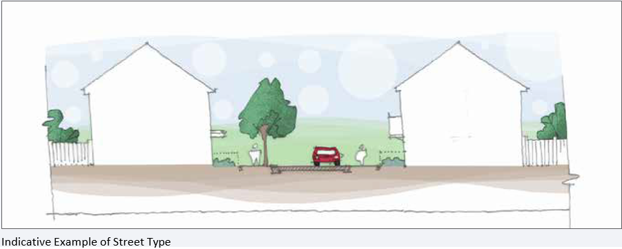
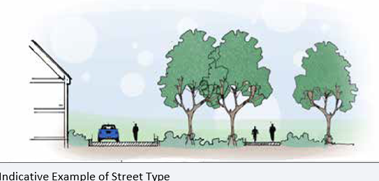
Primary Streets |
|
Role |
|
• Corridors that should incorporate multiple modes of transport; • Existing trees/hedgerows or new planting central to corridor; • Priority to be given to pedestrian/cycle routes; |
|
Parking |
|
• Varied parking strategies; • on-plot and parallel visitor spaces within road; • Side/rear courtyard parking potential where there is no alternative practicable solution; |
|
Width |
|
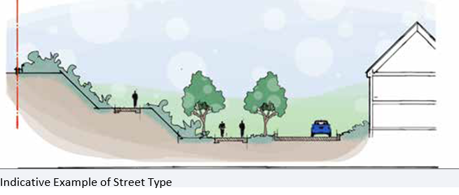
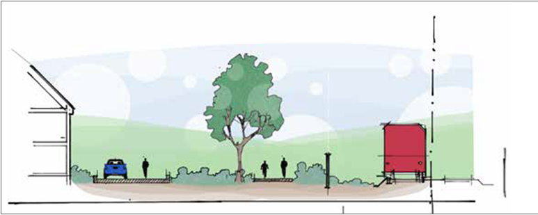
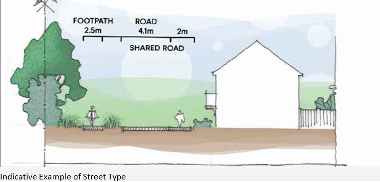
• 6.5m min. width to road; • 2m min width verge for parking/landscaping; • 2m min. pedestrian footpaths • 3m wide segregated cycleway; |
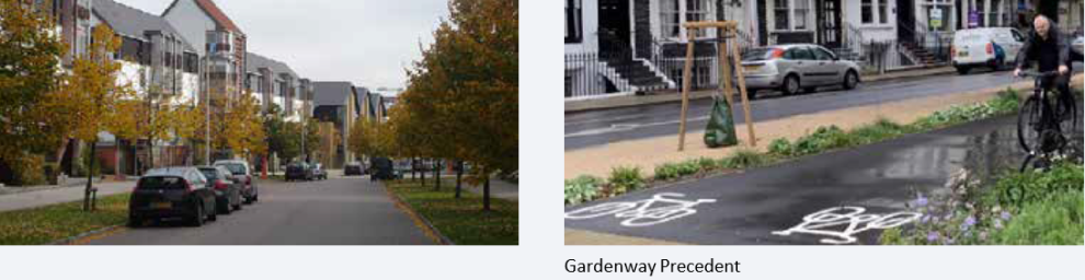
Gardenway Precedent
Indicative Example of Street Type
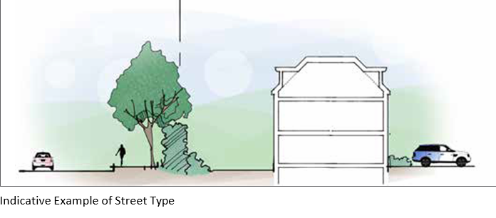
|
Street Type |
|
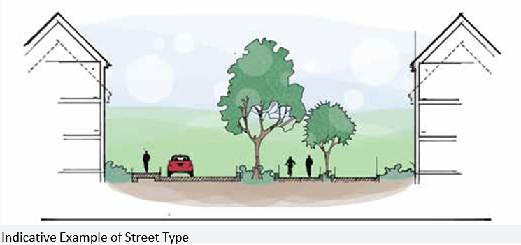
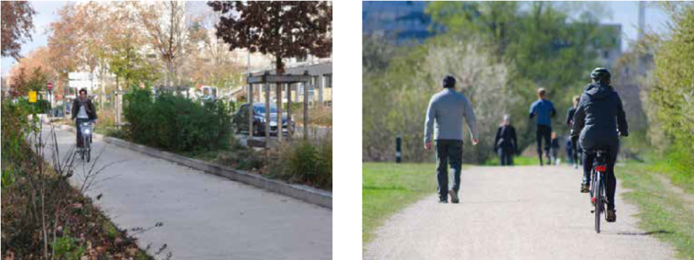
Pedestrian / Cycle Routes |
|
Role |
|
• Direct routes following desire lines with existing trees/hedgerows or new planting central to corridor; |
|
Parking |
|
N/A |
|
Width |
|
• 3m min. segregated cycle route; • 2m min. segregated pedestrian route |
Indicative Example of Street Type
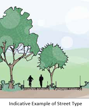
|
Street Type |
|
Secondary Streets |
|
Role |
|
• Streets that should connect the primary corridor, or secondary access points, to the wider areas of the development; • Domestic scale of buildings with frontage to both sides of the road; • Opportunities should be explored for street trees where possible; |
|
Parking |
|
• On-plot primary method of parking; • frontage parking; |
|
Width |
|
• 5.5m min. width to road; • 2m parking / landscape verge where possible; • 2m min. width to footpath to at least one side |
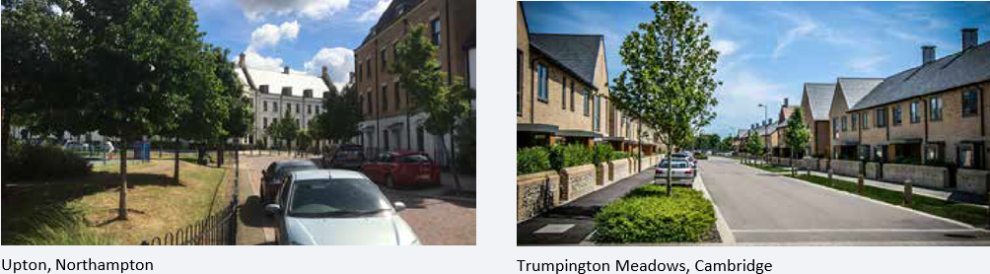
Upton, Northhampton and Trumpington Meadows, Cambridge
Indicative Example of Street Type
|
Street Type |
|
Lower/Wendover Road Frontage |
|
Role |
|
• Development edge facing existing Lower Road and Wendover Road; • Built form accessed from within site therefore opportunity to push building frontage closer to road – avoid 'parallel' roads adjacent to existing road where possible; • Strong development edge – apartments, terraces, semi-detached houses • Existing hedgerow to be retained with breaks for direct access/visibility onto street; |
|
Parking |
|
• Where frontage road access then prioritise on-plot (side) parking; • Side/rear courtyard parking potential where there is no alternative practicable solution; |
|
Width |
|
• If Key route treat as Secondary street type with segregated pedestrian footpath/cycleway; • Opportunity for 5.5m integrated shared surface if in cul-de-sac/close arrangement serving 25 properties or less; • Opportunity for some direct housing frontage onto pedestrian footpath/cycleway; • 2m parking/landscape verge where possible; |
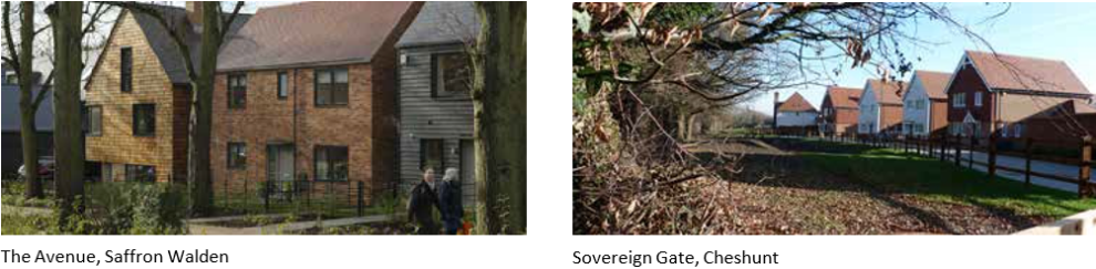
The Avenue, Saffron Walden and Sovereign Gate, Cheshunt
Indicative Example of Street Type
|
Street Type |
|
South East Aylesbury Link Road Edge |
|
Role |
|
• Development edge condition facing South-East Aylesbury Link Road; • Frontage should face towards South-East Aylesbury Link Road so amenity space is protected by built form; • Linked frontage where possible – apartments, terraces; |
|
Parking |
|
• Where frontage road access then prioritise on-plot (side) parking; • Side/rear courtyard parking potential where there is no alternative practicable solution; • Visitor parking in parallel bays in limited locations; |
|
Width |
|
• If Key route treat as Secondary street type with segregated pedestrian footpath/cycleway; • Opportunity for 5.5m integrated shared surface if in cul-de-sac/close arrangement serving 25 properties or less; • Opportunity for some direct housing frontage onto pedestrian footpath/cycleway; • 2m parking/landscape verge where possible; • Inclusion of maintenance road for South East Aylesbury Link Road bridge, with potential to perform dual role as pedestrian/cycleway route; |
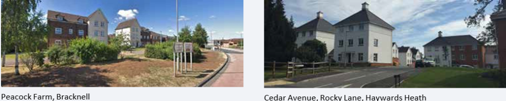
Peacock Farm, Bracknell and Cedar Avenue, Rocky Lane, Haywards Heath
Indicative Example of Street Type
|
Street Type |
|
Railway Edge |
|
Role |
|
• Development edge condition facing Railway corridor; • Frontage should face toward railway so amenity space is protected by built form; • Domestic scale frontage – terraces, semi-detached houses; |
|
Parking |
|
• Frontage parking acceptable to limit gaps between buildings; • Potential for some on-plot (side) parking; • Visitor parking in parallel bays to outer edge of street; |
|
Width |
|
• If Key route treat as Secondary street type with segregated pedestrian footpath/cycleway; • Opportunity for 5.5m integrated shared surface if in cul-de-sac/close arrangement serving 25 properties or less; • Opportunity for some direct housing frontage onto pedestrian footpath/cycleway; • 2m parking/landscape verge where possible; |
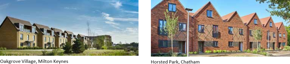
Oakgrove Village, Milton Keynes and Horsted Park, Chatham
Indicative Example of Street Type
|
StreetType |
|
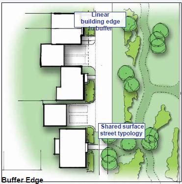
Buffer Edge |
|
Role |
|
• Development edge overlooking landscaped buffer; • Generally low density frontage to edge except around north-west area where buffer adjoins Local Centre on Wendover Road; • Opportunity for varied approach to buffer edge street – 'hard' edge to provide strong line of frontage overlooking buffer, feathered edge where development integrated with landscape setting; |
|
Parking |
|
• Prioritise on-plot (side) parking; • Visitor parking in parallel bays to outer edge of street; |
|
Width |
|
• If Key route treat as Secondary street type with segregated pedestrian footpath/cycleway; • Opportunity for 5.5m integrated shared surface if in cul-de-sac/close arrangement serving 25 properties or less; • Opportunity for some direct housing frontage onto pedestrian footpath/cycleway; • 2m parking/landscape verge where possible; • Opportunity for private drives to be considered to extents of street network; |
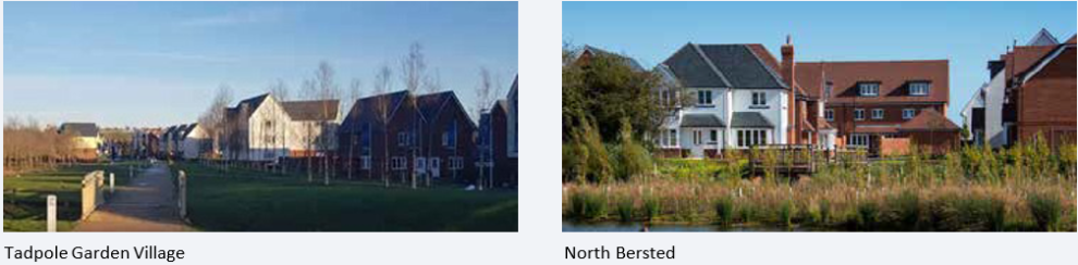
Tadpole Garden Village and North Bersted
Indicative Example of Street Type
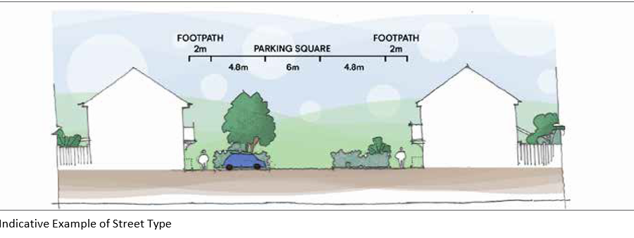
|
Street Type |
|
Courtyards |
|
Role |
|
• Squares located centrally within development blocks incorporating parking for surrounding buildings; • Strong frontage to ensure good surveillance and activity over parking square; • Design of courtyard should ensure adequate space for planting bays of min. 2m width to break parking up; |
|
Parking |
|
• Frontage parking within shared courtyard; • maximum of 4no. parking spaces between landscape bays; |
|
Width |
|
• 6m width between parking spaces – services within road if possible; • 2m footpath to rear of parking bays; |
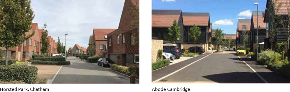
Horsted Park, Chatham and Abode Cambridge
Indicative Example of Street Type
|
StreetType |
|
Private Drive |
|
Role |
|
• Outer edge of street network, driveways serving small collection of houses (max. 5 houses) where maintenance vehicles are not required to enter; • Opportunity for inclusion along buffer edge or lower density areas backing onto existing properties; |
|
Parking |
|
• On-plot side parking, including side garages; • Frontage parking within shared courtyard; |
|
Width |
|
• 4.8m min. width, integrated shared surface |
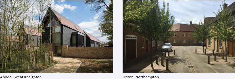
Abode, Great Kneighton and Upton, Northampton
Indicative Example of Street Type
4.3.3 Mobility Hubs
Sustainable Transport Hubs (also known as Mobility Hubs) have become a successful mechanism in many European countries to increase the uptake of active travel, low emissions and shared transport. The Hubs act as a convenient interchange at a neighbourhood level providing first and last mile connectivity with public transport, Demand Responsive Transport, car clubs, bike, eBike share and other services, whilst offering amenities such as electric vehicle charging points, charging for electric 'last mile' deliveries, cycle storage, workspaces, wifi, cafés and bike repair. This can help reduce car use and car ownership in a community. Through prominent signage and branding, the hubs act as their own advertising and research has shown that the majority of users first learn about the service after having passed by.
Mobility Hubs come in different shapes and sizes offering convenient and real alternatives which can be flexibly selected to serve the chosen neighbourhood.
Mobility Hubs can be located in new or existing residential areas, business parks, town centres, shopping centres and rural or suburban areas. They can help to plug gaps in the public transport network in a more cost effective way than new public transport services and unlock private sector investment. They harness new technologies in offering on-demand services which are growing in relevance to younger generations and proliferation in flexible working patterns.
Two mobility hubs could be provided within AGT-1 located on key movement routes within the development. They may form part of a connection to a wider centre or community square as a stand-alone building, or be adapted into a larger building such as the ground floor of a residential or communal building. Smaller mobility hubs could be located in outer areas of the development away from the central areas – such as e-Bike/e-scooter sharing points adjacent to pedestrian/cycle access points into AGT1.
|
EssentialComponents |
KeyPrinciples |
|
Electric vehicle Parking bays for car club |
Proximity to other neighbourhood amenities within 10 minute walk |
|
High-quality bicycle parking |
High quality facilities |
|
Proximity to a public transport stop |
Wider shared mobility programme across the city |
|
Safety (e.g. good lighting) |
Clear and visible branding and signage |
|
Easily accessible for everyone |
Unique name for each Mobility Hub (akin to bus stop names) |
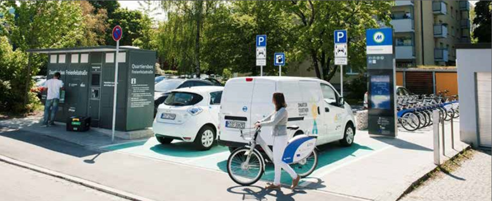
Mobility Hub Example showing electric vehicle charging, cycle hire, information board, drop off/collection facilities
- Munich
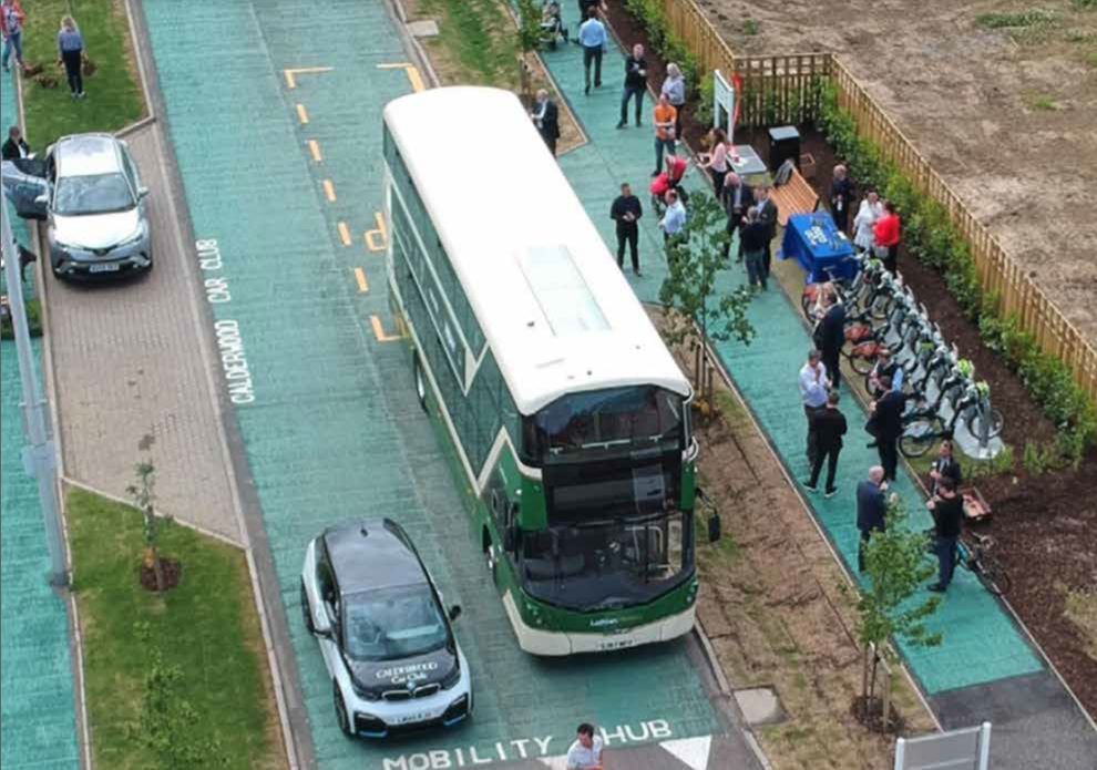
Mobility Hub Example showing bus stop, car club parking, cycle hire facilities - Calderwood, West Lothian
4.3.4 South-East Aylesbury Link Road/Railway Crossing Locations
The Framework Masterplan identifies potential locations for pedestrian and cycle crossing points, to ensure each neighbourhood area has good connections to each other and in all directions to the surrounding area
Options for the potential design of the South-East Aylesbury Link Road embankment and the form of access between the bridge over the railway and the development in AGT1 are provided with the landscape information in section 4.2.3.
- South-East Aylesbury Link Road Underpass – north-south movement is to be strengthened with the aspirational new route connecting Stoke Mandeville Hospital and Stadium with Stoke Mandeville Village. This should be incorporated within designs for AGT1 and as part of this the design of the underpass through the South-East Aylesbury Link Road for pedestrians and cyclists should be carefully considered.
- The width and 'containment' of the underpass should be considered to ensure users do not feel enclosed and in areas that could pose a risk to their safety;
- The underpass should be well lit and utilise design techniques to ensure natural light can serve as much of the route as possible, and use materials that are light and help reduce the darkness that similar routes can have;
- The underpass access points should be overlooked as much as possible by the new development within AGT1. Therefore buildings closest to the ramps should have frontage and habitable windows overlooking this space;
- Future Crossing Point - A further, potential future crossing point has been identified on the Masterplan, as a potential pedestrian footbridge crossing the railway at a southern point in AGT1 that Buckinghamshire Council may seek to bring forward in the future. The future design of this piece of infrastructure should ensure:
- That it seeks to integrate within the Strategic buffer within which it will be located, and ensure views from the Chilterns Area of Outstanding Natural Beauty are acknowledged and mitigated if necessary;
- Its location and design should ensure acceptable impact on the design of adjacent areas of housing development in AGT1.
- The housing in these areas should be designed to overlook the key landscape feature of the buffer, and therefore ensure that the potential future crossing has development frontage towards it, albeit at a distance.
- South East Aylesbury Link Road Potential Bridge Crossing - a potential vehicle crossing over the South East Aylesbury Link Road joining Area 1 (northern area) with Area 2 (western area). The need for this bridge will be known once the potential for vehicle access into the northern area is clarified. The potential design of this bridge should ensure:
- The bridge should be designed to integrate with the wider AGT1 Framework Masterplan as outlined in section 4.1;
- It should ensure an acceptable relationship with the adjacent new housing with regards to privacy and overlooking;
- It should not prohibit east-west pedestrian/cycle movement along the southern edge of Area 1 or the northern edge of Area 2;
1. South-East Aylesbury Link Road Underpass
2. Future Crossing Point
3. South East Aylesbury Link Road potential bridge crossing
4.4 Development Area and Character
Development Blocks
To establish a legible and safe environment, buildings should establish a frontage along the perimeter of all development parcels.
Front doors and ground floor windows should be positioned to promote natural surveillance of the streets they look out upon.
All back to back and back to side relationships should be acceptable in terms of overlooking, privacy, daylight and sunlight.
In order to ensure intersections are properly defined, buildings should be placed on the corner of every block to aid place- making.
Frontages
Buildings should front onto retained vegetation so that vegetation comes into the public domain and is more easily managed. Where vegetation is at the rear of existing gardens then alternative treatments may be required to unsure security and privacy is maintained.
Key Spaces
Key spaces should be accentuated by a combination of surrounding building frontages and landmarks, treatment of the space with regard to its surface, and it use and role within the development.
Key spaces should be actively overlooked from surrounding buildings, and these buildings should generally be orientated so that front doors open directly onto the space.
Edges
Sensitive edges should be informed by the adjoining context, with privacy maintained where required
Building elevations should engage with the public realm. Where more than one elevation engages with the public realm, the building must be designed in the round so as to engage fully with its entire context, not just the street facing the primary façade.
At crossroad intersections, all four corners should be framed by buildings
Section 3.2.6 outlines four development areas within AGT1 and how these could have differing character. This section provides indicative design guidance and principles for each of these areas that should be adopted within forthcoming designs.
Information on each area has been broken down to cover the topics below and provide indicative design guidance on a number of subject matters:
- Area Overview– overview of the character area and indicative illustration of potential layout;
- Urban Design Framework – overview of indicative layout with design principles for frontages, key routes and spaces, density and feature buildings;
- Key Routes and Spaces– Indicative examples of how some of the key routes or spaces could be provided
- Building Typologies– reference and precedent information of potential building typologies that suit the density and heights;
- Area Key View– artist's impression of one of the key areas and function of the space;
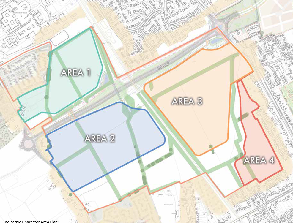
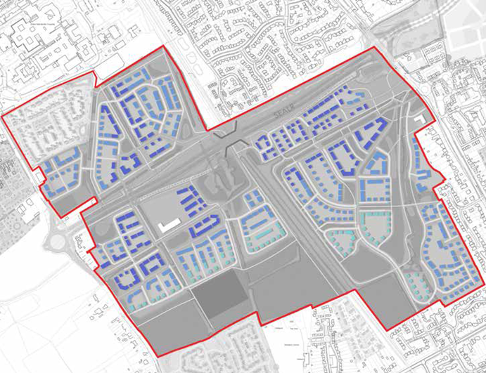
Indicative Character Area Plan
4.4.1 Area 1 - Northern Area
Overview
Features of this character area include:
- Outwardly facing development onto the South-East Aylesbury Link Road to mitigate noise source;
- Creation of gateway arrival space around vehicle access;
- Creation of landscaped arrival space for pedestrians and cyclists from existing neighbourhood to north;
- North-south green corridor around existing Public Right of Way and hedgerow with strong development frontage;
- Development to overlook landscaped arrival space linking with the South-East Aylesbury Link Road underpass;
- Creation of internal green spaces and squares within development platform;
- Higher Density built form to central spine and aligning the South-East Aylesbury Link Road;
- Medium density elsewhere including land parcel off Lower Road to match adjacent development;
- Potential for a vehicle link to north-west linking with new Crest Nicholson development;
Area 1 Indicative Features Plan
Area 1 Indicative Features Plan Key
Urban Design Framework
Key design principles for Area 1 should follow the guidance of the urban design framework sketch adjacent, with particular reference to the following:
- Vehicle Access - to Area 1 is subject to ongoing technical considerations. There are two options for crossing the South-East Aylesbury Link Road and linking with Area 2 to the south. These comprise an underpass in the south east corner and a bridge to the south west that are both technically feasible but subject to more detailed assessment. There is potential for some housing to be accessed directly off Lower Road, just north of the South- East Aylesbury Link Road junction. There is potential for a further connection through to the existing development to the north west. A 'left in/left out' access off the SEALR could be explored if all other options would leave the land parcel inaccessible and incapable of development.
- Edges – are generally outwardly facing towards the boundary as there is no adjacent development to be respected. Strong frontages should be adopted and perimeter blocks should be created to the development areas.
- Movement Corridors – should align with existing hedgerow/tree lines to establish multi- purpose green corridors through Area 1. These corridors should respect the existing vegetation and therefore be wide, with space for incorporation of Surface Water Drainage within the corridor design. Development should overlook these corridors and be intensified to maximise activity and surveillance over the route.
- South-East Aylesbury Link Road Crossing Point – suitable locations for ramps & steps crossing the embankment aligning the road should be reviewed collectively with the emerging designs for Area 1. The location of these crossing points should facilitate direct connections with the key movement corridors in Area 1, and also be located to minimise the extent of ramps and steps, for ease of access for all. Level access connections with the footpath along the South-East Aylesbury Link Road will be available along the south western edge of Area 1.
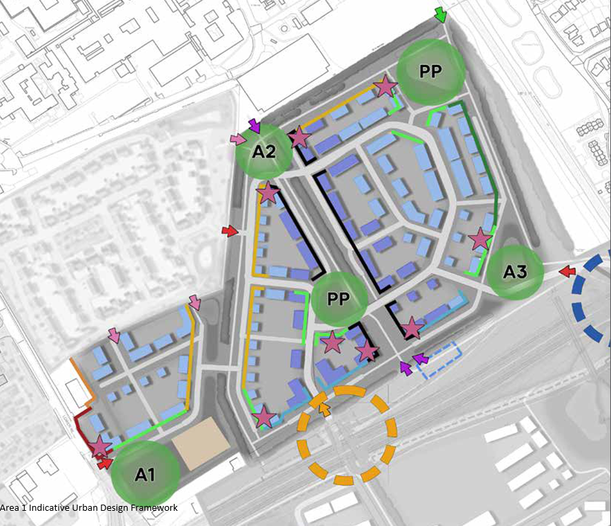
Area 1 Indicative Urban Design Framework
Key Routes and Spaces
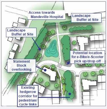
Stoke Mandeville Hospital Arrival
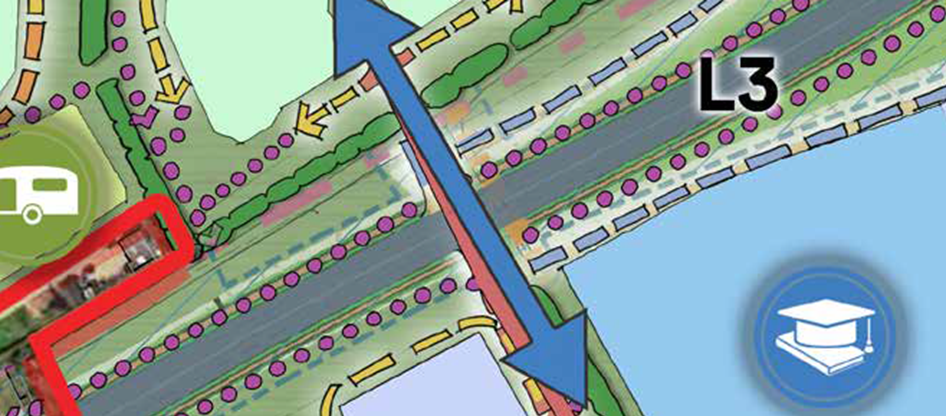
The Northern Arrival space is a key location for the whole of AGT1 being the entry point to the site from the Stoke Mandeville Hospital area, including its Local Centre and Stoke Mandeville Stadium facilities, therefore is likely to be very well used. As such an attractive arrival space should be created, with buildings surrounding the space and overlooking it, and opportunities for key statement buildings on the corners of ends of development blocks. There is potential for inclusion of a minor mobility hub in this location, which could provide e-bike or e-scooter access for use when travelling northwards from AGT1 towards Aylesbury centre.
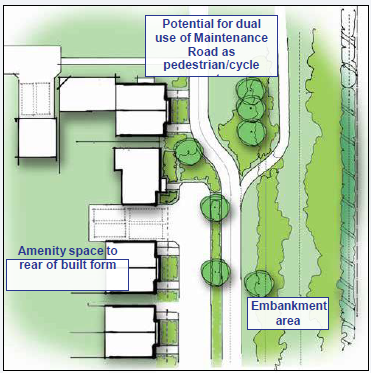
South-East Aylesbury Link Road Edge
Buildings should face towards the South-East Aylesbury Link Road to ensure amenity space is protected from noise by the building line. As such a strong and linked building line should be created consisting of apartments, terraces and linked houses. There is opportunity for 'car-free' frontage here - the maintenance road serving the South-East Aylesbury Link Road could perform a dual function as a pedestrian/cycle route along the edge of the development area.
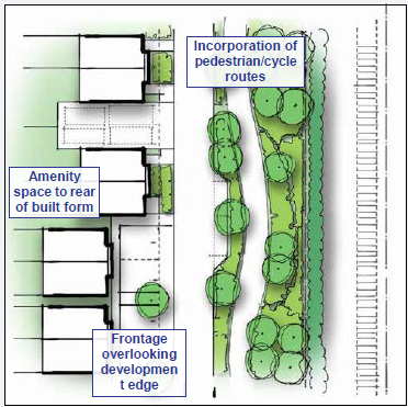
Railway Edge Plan
Buildings should face towards the railway edge to ensure amenity space is protected from noise by the building line. Within the landscape buffer alongside the railway corridor should be located a pedestrian/cycle route connecting Stoke Mandeville Hospital area with the South-East Aylesbury Link Road underpass and onwards to the south. Opportunity for on-street visitor parking in parallel bays on outer edge of road, aligning landscape buffer.
Building Typologies
The design of building forms and use of materials must reference an understanding of the local character. A character study should be conducted as part of the design process and used to help inform the appearance of the proposed buildings.
Building forms in Area 1 must have a relevance to the local vernacular and take visual cues from the area, such as the local context in Stoke Leys and emerging development to the north- west.
Contemporary forms of buildings can be proposed however should be informed by the character study in terms of building form, roof scape, facade composition and window hierarchy.
All buildings should use materials that are durable, age well and are positively enhanced by weathering. Material choice will be informed by a character study of the area and strong design rationale for the specific character area within which the buildings are located.
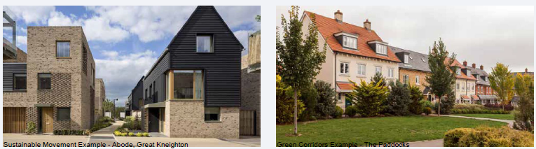
Sustainable Movement Example - Abode, Great Kneighton and Green Corridors Example - The Paddocks
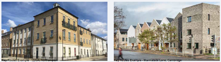
Key Routes Example - Marmalade Lane, Cambridge and Key Routes Example - Upton, Northampton
Local Reference - Stoke Leys and Example of Development Fronting onto a Major Road - Bracknell
|
BuildingTypology |
|
|
Apartments |
Gateway and Arrival Spaces |
|
Central North-South Corridor |
|
|
Key junctions within Area |
|
|
Terraced Houses |
Throughout, in particular Stoke Mandeville Hospital, South-East Aylesbury Link Road and Railway Edges |
|
Semi- Detached Houses |
Throughout |
|
Detached |
To edges such as fronting green corridors, or internal courtyards areas |
Area Key View
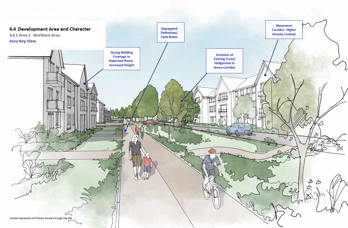
Artists Impression of Primary Route through the Site
4.4.2 Area 2 - Western Area
Overview
Features of this character area include:
- Creation of gateway arrival space off Lower Road;
- Incorporation of strategic east-west corridor integrating key movement route and green corridor, along route of existing Public Right of Way; high density development along this route;
- North-south green corridors around existing Public Right of Way and hedgerow with strong development frontage;
- Potential for location of Local centre uses such as Primary School at junction of movement routes and higher density along street;
- Creation of internal green spaces and squares within development platform;
- Creation of green spaces around edges of development area to incorporate Sustainable Drainage Systems within Green and blue infrastructure network;
- Lower density development along southern edge of development facing towards strategic buffer;
- Higher Density built form to central routes and development parcels aligning South-East Aylesbury Link Road;
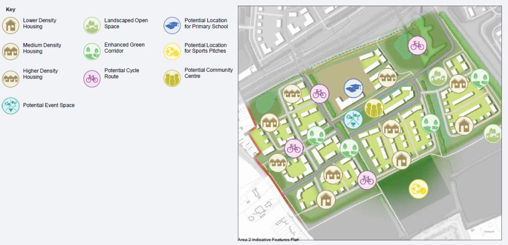
Area 2 Indicative Features Plan
Urban Design Framework
Key design principles for Area 2 should follow the guidance of the urban design framework sketch adjacent, with particular reference to the following:
- Movement corridors – key to the design of Area 2 is the 'grid' that is created when incorporating existing tree/hedgerows through the development area, and the potential opportunity to create a strong sustainable movement framework through the area. As with Area 1, these routes could be multi-functional by providing a green corridor and opportunities for surface water drainage integration in the street design.
- Edges–Area 2 is generally outwardly facing except for a small area in the north-west corner which backs onto existing houses, which should be respected. Elsewhere, development edges should provide a strong frontage towards the edge they face. The edge of Area 2 facing the South-East Aylesbury Link Road will be varied – where residential uses are proposed guidance as suggested in Area 1 should be incorporated – however note that if a primary school is to be included, part of the northern boundary will align this corridor and may require a specific treatment to address noise and surveillance matters.
- Primary School – as indicated in this SPD there is a nodal point in Area 2 where routes converge and at this location is the potential to include the primary school for AGT1. This would be in close proximity to Lower Road and therefore easily accessible, and also within the internal AGT1 framework allows for good access from the north, south and east. A central square incorporating play and mobility facilities could be included adjacent to the school.
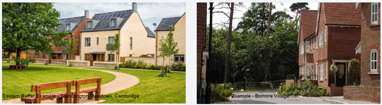
- Buffer–the layered concept studies in section 3 suggest that a linear edge to the buffer could be created in this part of AGT1. This edge could form an attractive feature when viewed from the buffer and form a key role in the identity of Area 2 and AGT1 as a whole.
- Central open space – frontage to overlook large open space area to north-east of Area 2; this space should be landscaped as outlined in section 4.2.5 and will include movement and connections with Area 1 and 3 to the north and east, therefore a strong frontage should be established facing this space with opportunities for focal buildings around routes to assist wayfinding;
- South-East Aylesbury Link Road crossing point – suitable locations for ramps & steps crossing the embankment aligning the road should be reviewed collectively with the emerging designs for Area 3. The location of these crossing points should facilitate direct connections with the key movement corridors in Area 3, and also be located to minimise the extent of ramps and steps, for ease of access for all. Level access connections with the footpath along the South-East Aylesbury Link Road will be available along the north eastern edge of Area 3.
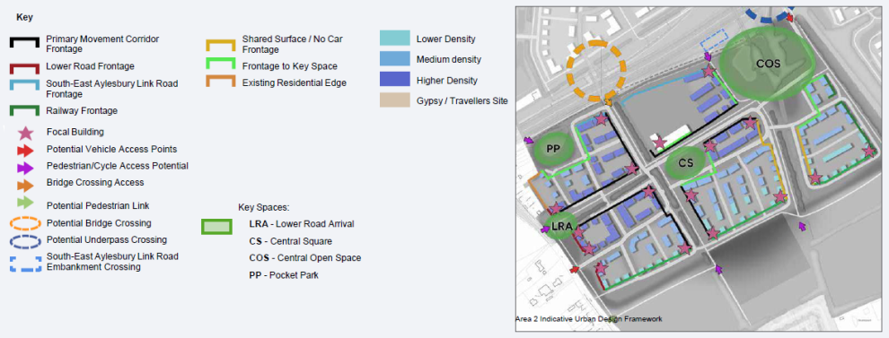
Area 2 Indicative Urban Design Framework
Key Routes and Spaces
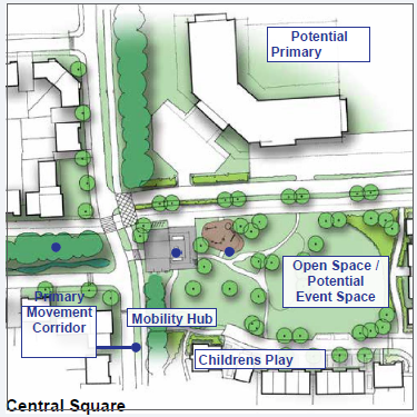
Central Square
A focal square could be designed centrally to Area 2 which acts as a space that the local community in this area can utilise, and therefore opportunity for increased density and height should be explored around the edge of this space.
This area should incorporate a local centre facility such as a primary school which should outlook onto this space and
therefore play a key role in placemaking. Mobility hub facilities could also be incorporated in this key space. The space is well located being on the junction of the key north-south and east- west movement corridors through Area 2.
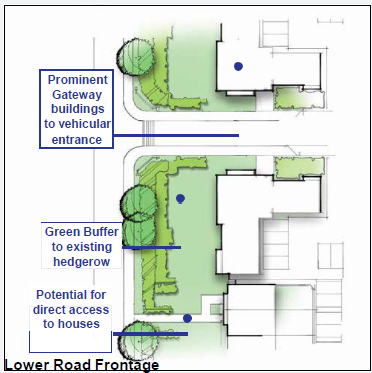
Lower Road Frontage
Buildings facing Lower Road are accessible from within the site, therefore opportunity to push building frontage closer to road – avoid 'parallel' roads adjacent to existing road where possible. Create a strong development edge by use of apartments as gateway blocks around entrances and elsewhere terraced cottages. The existing hedgerow should be retained with breaks for direct access/visibility onto street to the front doors or houses to enhance activity.
Buffer Edge
The buffer edge in Area 2 could form an attractive linear feature providing a strong edge to AGT1 when approached from Stoke Mandeville Village to the south. As such building types should seek to incorporate repetition, with gateway buildings created on the corners of blocks at the southern end of the movement corridors. The road edge however could be varied, with opportunities to be explored which allow for reduced road widths (shared surface or private drive) or car-free pedestrian frontage where possible with parking accessed from the rear.
Building Typology
Building forms in Area 2 must have a relevance to the local vernacular and take visual cues from the area, such as the local context in Stoke Mandeville Village. Contemporary forms of buildings can be proposed however should be informed by the character study in terms of building form, roof scape, facade composition and window hierarchy.
Suggested building typologies for key parts of Area 2 could be as follows:
- Buffer edge– repetition to buildings with larger plots framing corners of movement corridors;
- Central square – density to edges of square with use of terraces or apartment buildings and increased height; potential for statement buildings in key locations, such as new primary school;
- Movement corridors– strong building line along movement corridor with enhancement of surveillance over the route; development to transition towards southern end to reduced density and scale of building along buffer edge;
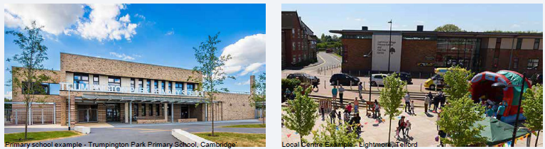
Primary school example - Trumpington Park Primary School, Cambridge' and Local Centre Example - Lightmore, Telford
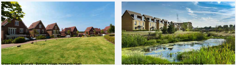
Green Edges Example - Bolnore Village, Haywards Heath and Western Buffer Example - Oakgrove Village, Milton Keynes
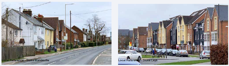
Local Reference - Stoke Mandeville and Local Reference - Stoke Leys
|
BuildingTypology |
|
|
Apartments |
Gateway and Arrival Spaces |
|
East-West Greenway Route |
|
|
Key junctions within Area |
|
|
Terraced Houses |
Gateway and Arrival Spaces |
|
East-West Greenway Route |
|
|
North-South Green Corridors South of East-West Greenway |
|
|
Lower Road Frontage |
|
|
Semi-Detached Houses |
Throughout |
|
Detached |
Spread South of East-West Greenway Route |
|
Buffer Edge |
|
Area Key View
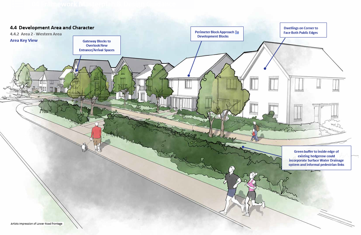
Artists Impression of Lower Road frontage
4.4.3 Area 3 - Eastern Area
Overview
Features of this character area include:
- Creation of arrival space off Wendover Road to include northern end of strategic buffer;
- Potential to include Local centre uses around arrival space offering frontage to traffic on Wendover Road;
- Incorporation of strategic east-west corridor integrating key movement route and green corridor, along route of existing Public Right of Way; high density development along this route;
- Creation of internal green spaces and squares within development platform;
- Eastern edge of development area to overlook strategic buffer; transitional frontage from high density around arrival space to lower density at southern edge;
- Lower density development along southern edge of development facing towards strategic buffer;
- Higher Density built form to development parcels aligning the South-East Aylesbury Link Road;
- Development to overlook landscaped pedestrian/cycle arrival space linking with the South-East Aylesbury Link Road underpass;
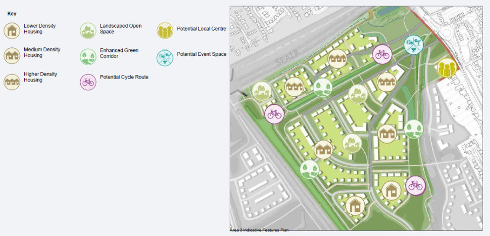
Area 3 Indicative Features Plan
Key design principles for Area 3 should follow the guidance of the urban design framework sketch adjacent, with particular reference to the following:
- Wendover Road Arrival – key to the design of Area 3 is the creation of an arrival space which forms a dual use as the northern most section of the buffer through AGT1. The buffer should be provided with positive frontage on both sides therefore buildings should be located on the eastern edge backing onto the existing houses along Wendover Road. Built form here should be orientated to face Wendover Road and therefore protect amenity to the adjacent dwellings.
- Local centre – from the reviews of placement of uses there is an opportunity to locate the Local Centre at the nodal point adjacent to the entrance area off Wendover Road. This would be visible by passing traffic and in a location accessible to residents of AGT1 via the key east-west movement corridor and movement routes within the buffer. Built form should 'hold' this corner providing frontage onto Wendover Road and also northwards to the arrival space;
- Movement corridor – this should be a similar east-west corridor as in Area 2, however in Area 3 the existing hedgerow is a much stronger feature. Therefore opportunity to split the movement types (road, footpath, cyclepath) either side of the hedgerow and treat the area as a key 'space' rather than a corridor.
- Buffer– the edge of Area 3 adjoining the buffer could be treated in a similar fashion to Area 2, however to set this apart and provide a more informal edge to the space,
- opportunity could be explored for a non-linear development edge allowing for extensions to the buffer via small 'pockets' of open space around which dwellings should be located;
- Pocketparks– opportunities to be explored to include pocket parks of various sizes to create interest within development areas and promote sense of community.
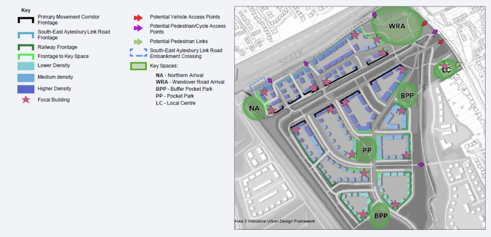
Area 3 Indicative Urban Design Framework
Key Area Locations
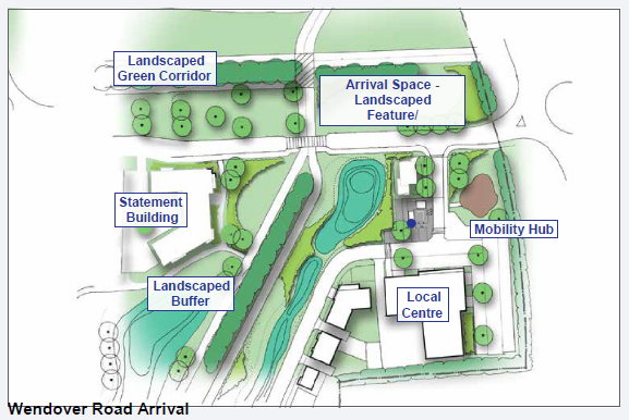
Wendover Road Arrival
Opportunity for focused space around main eastern arrival to AGT1. Located in what will be a heavily used nodal point of north-south and east-west movement, and as such integration of these routes and placement of facilities will be key to the success of the space. Local centre frontage proposed overlooking the corner of the arrival space, with creation of an external space fronting onto the open space in this area. There is potential within this external space to locate mobility hub facilities including a kiosk, drop-off collection lockers, e-bike or e-scooter racks and a cycle repair shop.
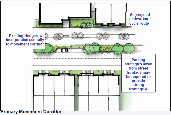
Primary Movement Corridor
At the centre these movement routes include either existing tree/hedgelines or proposed new planting. Around these should be positioned the key movement elements and these can be split either side of the treeline to reduce the amount of hardstanding in one area and improve the quality of landscape across the space. Building frontage should be strong along the edge with a continuous line where possible, parking located away from the front to ensure facades are close to the space, and opportunities for key focal buildings on corners of junctions with other routes.
Building Typology
Building forms in Area 3 must have a relevance to the local vernacular and take visual cues from the area, such as the local context in Stoke Mandeville Village. Contemporary forms of buildings can be proposed however should be informed by the character study in terms of building form, roof scape, facade composition and window hierarchy.
Suggested building typologies for key parts of Area 3 could be as follows:
- Movement corridors– strong building line along movement corridor with enhancement of density and height to ensure surveillance over the route;
- Wendover Road arrival – potential for series of statement buildings around space given distance between development areas; blocks can be linked architecturally and create a potential identity at the entrance gateway which could be referenced within Area 3 and other areas of AGT1;
- Buffer edge – Creation of a varied edge comprising collections of differing building forms, however with elements of repetition focussed around pocket park space extensions to the buffer;
- Pocket parks– potential increase to density around central squares with prominent buildings located on corners of key routes leading through the space;
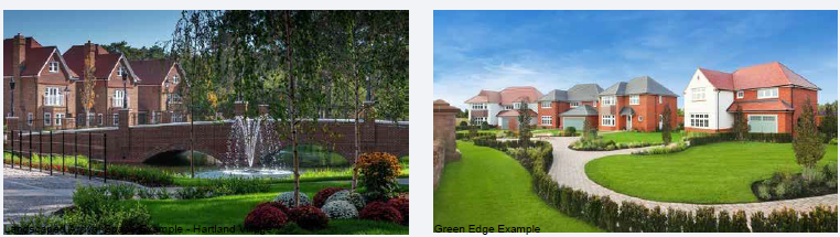
Landscaped Arrival Space Example - Hartland Village and Green Edge Example
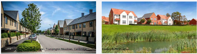
Internal Residential Streets Example - Trumpington Meadows, Cambridge and Eastern Buffer Example
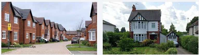
Local Reference - Stoke Leys and Local Reference - Stoke Mandeville
|
BuildingTypology |
|
|
Apartments |
Gateway and Arrival Spaces |
|
East-West Greenway Route |
|
|
Key Junctions within Area |
|
|
Terraced Houses |
Gateway and Arrival Spaces |
|
East-West Greenway Route |
|
|
North-South Green Corridors South of East- West Greenway |
|
|
Railway Edge |
|
|
Semi-Detached Houses |
Throughout |
|
Detached |
Throughout |
Area Key View
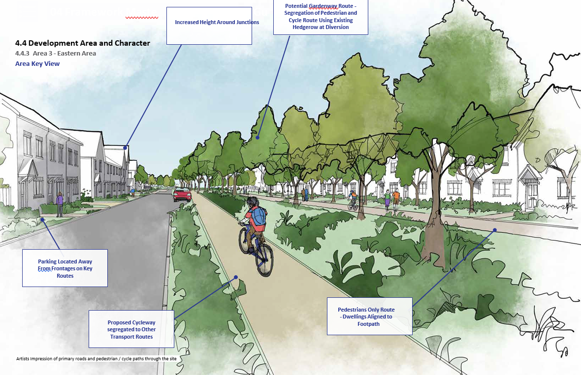
Artists Impression of primary roads and pedestrian / cycle paths through the site
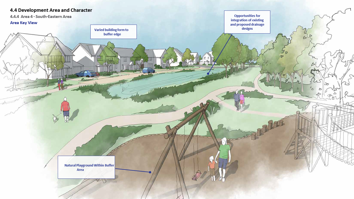
4.4.4 Area 4 - South-Eastern Area
Overview
This character area will include features such as:
- Development to extend up to boundary of AGT1 in south-east area to provide security and privacy to existing rear gardens adjoining this boundary;
- Development to face towards Strategic buffer to provide positive frontage; screening of dwellings either side of buffer proposed via retention and enhancement of tree/hedgerow planting along wetland corridor;
- Access points across buffer between Eastern Area and Stoke Mandeville Village Extension area to be sensitively incorporated through existing hedgerow;
- Other existing hedgerows to be retained with development parcels broken up around the landscape assets;
- Western edge of development area to overlook strategic buffer; transitional frontage from high density around arrival space to lower density at southern edge;
- Creation of internal green spaces within development platform;
- Medium density development to this area generally;
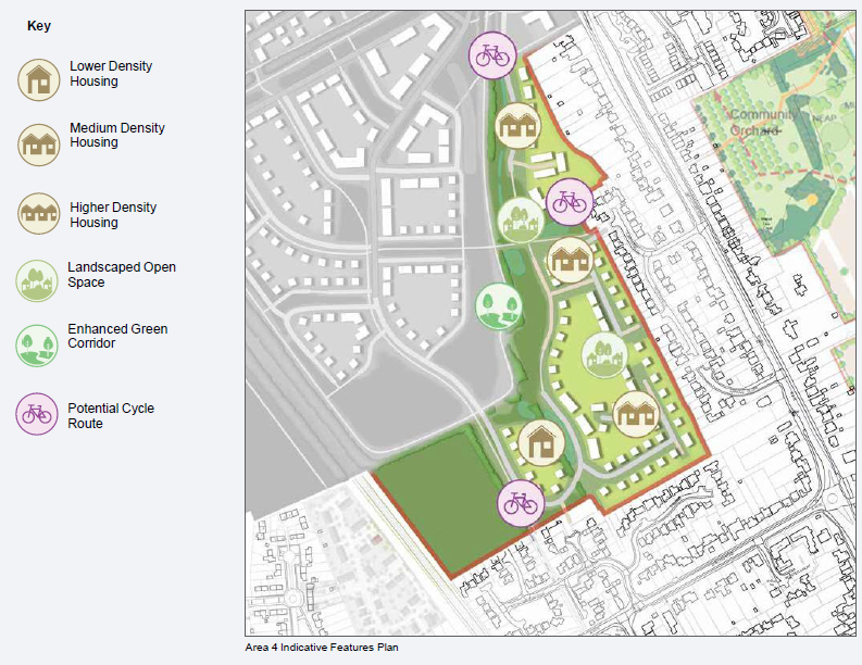
Area 4 Indicative Features Plan
Key design principles for Area 4 should follow the guidance of the urban design framework sketch adjacent, with particular reference to the following:
- Southern arrival– a 'low-key' informal arrival space can be created at the southern most extent of the buffer where existing and proposed access points are to be created linking AGT1 and Stoke Mandeville Village, ensuring the existing setting in this area for footpath routes is maintained. Development will be set within existing field enclosures in the area therefore screening buildings from the buffer, and therefore pedestrian routes in this space will be segregated from the development. Opportunities to link these routes with the new houses through the existing hedgerow, where appropriate, should be explored to enhance safety of the route.
- Eastern arrival – a vehicle access point can be provided from Castelfields to the east, therefore this should be treated as a secondary access serving a limited number of dwellings, and therefore the style of space should also reflect this role. The space can also cater for pedestrian and cycle movement through to Wendover Road. Central to the space is a collection of existing trees. New buildings should be orientated to overlook this arrival, and focal buildings should be provided on the corners of the this route where it meets the buffer.
- Existing residential edge– development of Area 4 should extend to the existing settlement edge in the south-east corner of AGT1. This is unlike other parts of AGT1 where the buffer is located between AGT1 development and Stoke Mandeville, however this does ensure that the buffer within AGT1 is provided with a positive frontage overlooking the buffer on both sides. Locating the buffer along the rear boundary could create a space prone to crime that is not overlooked. As such privacy should be respected in this area by creating 'back to back' relationships to the existing houses at appropriate distances. Building form along this edge should be reduced in density to predominantly detached houses with gaps between them formed by on-plot parking to the side and garages to reduce the built form.
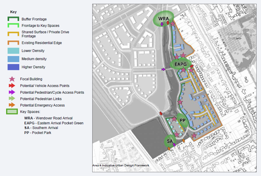
Area 4 Indicative Urban Design Framework
Key Area Locations
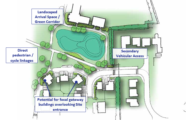
Eastern arrival space
The eastern arrival should be a low key space incorporating a secondary vehicle access and pedestrian and cycle movement. Buildings should be placed to overlook the entrance with potential for a focal building on the entry to AGT1. Buildings should be orientated to overlook the space created here which is centred around the retention of a tree group in the centre of the space.
Opportunities for integrated sustainable urban drainage can be included within a landscaped space. Buildings around this entrance should be of a similar typology to those existing in Stoke Mandeville; detached and semi-detached at 2 storey with potential for 2 ½ around the open space.
Buffer edge
The development edge of Area 4 to the buffer could be a very informal edge evoking the feathered edge to Stoke Mandeville that is elsewhere along its northern boundary. Where Area 3 suggested
a potential for elements of linear edge broken by small pocket park extensions to the buffer, Area 4 could be more random and dictated by the line of the existing 'brook' which runs within the buffer. This could allow for a unstructured building edge with irregular corners and building orientated 'side' on rather than facing the buffer, to create small enclosures of space away from the main buffer area. Buildings should predominantly be detached along this edge if this style is to be progressed.
Building Typology
Building forms in Area 4 must have a relevance to the local vernacular and take visual cues from the area, such as the local context in Stoke Mandeville Village. Traditional forms of buildings may be proposed and therefore should be informed by the character study in terms of building form, roof scape, facade composition and window hierarchy.
Suggested building typologies for key parts of Area 4 could be as follows:
- Buffer edge – Creation of a varied edge comprising differing building forms, predominantly detached houses with potential for small number of cottage style houses around edge spaces;
- Existing residential edge– predominantly detached houses to ensure density is reduced and street scene is softened; create gaps in the street scape by use of side parking and garages.
- Internal streets– opportunities to include an small increase to the density within the centre of the development area around internal courtyards and streets with development on both sides.
Sustainable Movement Example and Courtyards & Edges Example - Bolnore Village, Haywards Heath
Eastern Buffer Example - Trumpington Meadows, Cambridge and Eastern Buffer Example - Bolnore Village
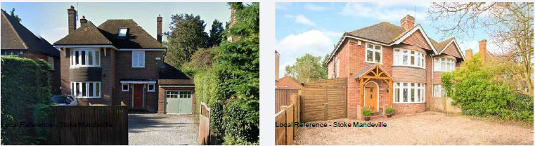
Local Reference - Stoke Mandeville
|
Building Typology |
|
|
Terraced Houses |
Central Areas of Development Cells |
|
Small Scale Pedestrian Connections with existing Residential Areas - Castlefields, Petersfield, Carters Ride |
|
|
Semi- Detached Houses |
Central Areas of Development Cells |
|
Small Scale Pedestrian Connections with existing Residential Areas - Castlefields, Petersfield, Carters Ride |
|
|
Stoke Mandeville Village Edge |
|
|
Detached |
Throughout |
Area Key View
Artists Impression of Buffer Edge
4.4.5 Scale and Density
The Framework Masterplan should adopt a density strategy to respond to the context within which each development area is located. The Framework Masterplan should take opportunities to increase density and scale around key movement routes and nodes through the site, and reduce density in sensitive areas. Based on the development of character areas as outlined over the forthcoming pages, an overarching density strategy for AGT1 should be developed as follows:
|
LowerDensity |
approx. 25-29dph |
|
Building types |
detached building typologies |
|
Building heights |
generally up to 2 storey building heights |
|
Lower density areas of development should be located to the southern periphery of the AGT1 area adjacent to the proposed landscape buffer, and to some of the areas in the south-east of the site where development will back onto the existing settlement edge of Stoke Mandeville Village |
|
|
Medium density |
approx. 30-39dph |
|
Building types |
transitional development area utilising a mixture of building types from the adjacent low and high density areas of development; small number of apartments, some terrace, semi-detached and detached houses |
|
Building heights |
generally 2 and 2 ½ storeys in height, allowing for some increase in height to 3 storeys in key locations |
|
Should generally be located within development areas as a transition between the higher and lower density areas or where it reflects the adjacent context. Opportunity for some variance with the density within this zone, such as higher around courtyards & squares where smaller properties improve activity and frontage, and lower to edges where relating to adjacent context. |
|
|
Higher Density |
approx. 40+dph |
|
Building types |
predominance of linked building typologies such as apartments and terraces |
|
Building heights |
generally 2 and 2.5 storeys in height including taller buildings up to 3 storeys and 4 storeys in limited key locations |
|
Higher density areas should be located centrally to AGT1 within the central development areas, specifically along the east-west axis between the Primary Movement Corridor and the South-East Aylesbury Link Road corridor. The northern development area also has opportunities for higher density buildings and heights due to the existing context of larger buildings to the north around Stoke Mandeville Hospital, which should be set along the north-south movement corridor through this area. |
|
Indicative Site Density Plan
Note - The guidance provides general principles and that the context may change with other design solutions being appropriate if justified at detailed design stage.
4.5 Land Uses and Facilities
For the South Aylesbury development to be successful the focus for the development is not only on what is to be built but also on how it creates a sustainable, vibrant, healthy, and prosperous community whilst protecting and enhancing the environment in which is it situated.
4.5.1 Placement of Uses
Facility : Primary School
Location: Locate to the west of the railway line within the centre of the site
Justification:
- Most central location within D-AGT1 therefore the most accessible location to the majority of AGT1 residents.
- Link to western mobility hub.
- Education supports a central location within D-AGT1.
- Encourages walking / cycling to school from all areas of D-AGT1, including the northern parcel, to the north of the South-East Aylesbury Link Road, and the eastern parcel.
- Located appropriate distance from other school in the local area (i.e. William Harding, Stoke Mandeville and proposed school on Hampden Fields)
- Access to Lower Road, with traffic movements split from the local centre.
- Will have close links with Stoke Mandeville Parish Centre should this come forward on Lower Road; whilst position proposed within AGT1 allows for good accessibility with the rest of the development
Facility : Community Building
Location: West of railway line
Justification:
- Appropriate central location within D-AGT1 therefore providing the most accessible location to the majority of AGT1 residents.
- The proposed position within AGT1 allows for good accessibility with wider area around AGT1 including southern Aylesbury and Stoke Mandeville.
- Located in close proximity to the proposed school therefore allowing shared use of resources and potential use by the school.
- Access to Lower Road, with traffic movements split from the local centre with the potential for linked trips with the adjacent school.
- Located appropriate distance from other similar facilities.
- Link with western mobility hub.
Facility: Local Centre
Location: Locate to the east of the railway line adjacent to Wendover Road
Justification:
- Link to eastern mobility hub.
- By locating on the edge of the site the facility will be more visually and locally available therefore making uses more likely to be economically solvent.
- Located away from existing Asda supermarket and provision within Stoke Mandeville, both of which are in close proximity to the western parcel.
- Accessible to Wendover Road and passing trade / pass by trips.
- Accessible to existing residents of Stoke Mandeville / Stoke Grange.
- Smaller, subsidiary local uses could still be provided, if demand is sufficient, to the western parcel.
- The Parish Centre, as part of the draft Stoke Mandeville Neighbourhood Plan identifies land around Lower Road for retail facilities.
- Some local centre uses (eg Hot Food takeaway) would create conflict if located adjacent to the primary school.
- Good and direct access to Wendover Road, with movements split from the school.
- Potential vehicle congestion if located adjacent to the school at peak school times.
- Located in close proximity to the existing public right of way crossing the site and the proposed Gardenway route where it enters the site from Wendover Road.
Facility: Gypsy/Traveller Pitches
Location: Locate on land adjacent to the South-East Aylesbury Link Road and Lower Road
Justification:
- Independent location on a discrete parcel of land.
- Direct and independent access from the road network can be provided, whilst pedestrian links still possible with wider site.
- Excellent vehicle access to Lower Road (B4443) and the South-East Aylesbury Link Road is provided, therefore providing good access to the wider road network.
4.5.2 Housing
The development will, in line with policy, create at least 1,000 dwellings, with potential to achieve more at an appropriate density together with the provision of 5 Gypsy and Traveller pitches (0.34 hectares). The density of development will consider the adjacent existing settlement character and identity, creating a balanced, sustainable, and attractive community with a diverse range of housing forms and types.
South Aylesbury may be suited to a different mix of new homes from that which might be provided within other parts of the authority. Proposals will be expected to deliver a mix of houses and apartments with a range of sizes from 1-bed through to 4+ bed properties. The housing mix provided will consider the Council's most up-to-date evidence on housing need together with local market conditions and requirements, ensuring it meets current and future housing needs. Flexibility will be applied in terms of mix for individual phases or parcels within the site, reflecting the timing and nature / character of the area being developed.
Through the provision of a variety of accommodation types, including the provision of an overall objective to deliver 25% affordable dwellings on individual phases or parcels within the site, an inclusive environment will be created. A range of housing tenures will be supported on the site, together with a variety of housing types and sizes aimed at meeting the needs of the local population to enable households to more easily find housing which suits their needs and that they can afford.
The Vale of Aylesbury Local Plan (Policy H5) requires that developments proposing 100 dwellings and above, including partial developments of a wider site, provide a percentage of serviced plots for sale to self/custom builders. Numbers will be determined on a site-by-site basis at the planning application stage and will be dependent on evidence of demand and viability.
Affordable Housing Delivery
The Vale of Aylesbury Local Plan (Policy H1) seeks the provision of affordable housing on development of 11 or more dwellings, or sites of 0.3 hectares or larger with a minimum of 25% affordable homes provided.
The overall objective is to deliver 25% affordable dwellings on individual phases or parcels within the site, with the type, size, tenure, and location of affordable housing to be agreed with the Council. This will take into account the Council's most up-to-date evidence on housing need and any available evidence regarding local market conditions. Affordable housing, including the provision of 'First Homes' where appropriate, should be delivered in step with market housing.
Residential development on the site will have regard to housing mix in terms of type, size, tenure, and location and be designed so that affordable housing is mixed with the market housing. There should not be undue clustering of affordable homes
Gypsy and Traveller Provision
The Council has identified that 5 pitches for gypsies and travellers will be needed as part of the affordable housing provision via Vale of Aylesbury Local Plan Policy D-AGT1(b). The pitches will be provided on the western parcel where independent, immediate, and good access from Lower Road can be provided. The area will be provided to the required size and will incorporate appropriate access and good quality landscaping.
4.5.3 Open Space and Green / Blue Infrastructure
To create a desirable place to live and to integrate the new development with the existing built area of Aylesbury and Stoke Mandeville, including the Grade II listed Magpie Cottage, attractive high quality new neighbourhoods will be developed creating a semi-natural environment whilst providing quality housing for both the private and social sectors.
South Aylesbury will accommodate 50% ANGSt compliant green infrastructure within each application parcel linking the new development areas to the wider area as part of a high quality built and semi-natural environment. Existing vegetation and habitats will be retained where practicable with urban greening and green / blue infrastructure incorporated, providing structural landscaping and a network of open spaces for informal use together with more formal sports provision.
The development of play and sports facilities will be in accordance with current appropriate design principles, contributing positively to the promotion of healthy communities and the requirements of good design. With children's play areas and outdoor sports provided where required and appropriate taking into account both new and existing residents.
Based on the average household size of 2.5 people (Vale of Aylesbury Local Plan Paragraph 1.51) the South Aylesbury development will generate a population of at least 2,500 people (based
on 1,000 dwellings). The development will, in line with Vale of Aylesbury Local Plan Appendix C, therefore aim to provide a minimum of 5 hectares of accessible natural green space (2 hectares per 1,000 population); 3.5 hectares of incidental open space (1.4 hectares per 1,000 population), and 3 hectares of major open space (1.2 hectares per 1,000 population), with 2 adult size grass pitches (0.73 adult size grass pitch equivalent per 1,000 population). The grass sports pitches are proposed to be located on the western side of the railway line.
The concept masterplan for the development makes provision for natural areas / corridors to be located to run through the site, including a strategic buffer running from Wendover Road to Lower Road. This will not only help retain the individual identity of the settlement of Stoke Mandeville but will act as an important linear park link through South Aylesbury and beyond. Walking and cycling routes, where practicable, will be delivered through these areas, with the buffer providing a potential route for the Aylesbury Gardenway.
The buffer, which will be developed in relation to the appropriate phases of development to ensure timely delivery, will act as a link between residential character areas and will itself change in character. Planning applications will ensure it has a natural character and isn't overly designed, with a gradual transition between character areas. The existing watercourse which runs through the eastern parcel and proposed buffer will be enhanced and its ecological status improved, whilst through the modification of the channel it will provide flood elevation measures, reducing the risk of flooding downstream.
The provision of blue networks through the site will enhance wildlife while providing important drainage and flood elevation measures. These features are likely to take a variety of forms depending on their location, including permanent standing water features, naturalized designs that remain dry most of the time providing open space when not required for mitigation, and formal hard-landscaped features.
4.5.4 Transport Connectivity
An important part of any development is the need to provide access in the form and location that is needed by its residents and the surrounding community. Ensuring that South Aylesbury is developed so that people can get to and from, as well as get around, by a range of different transport modes will help create an inclusive and sustainably accessible community.
Existing public rights of way will be incorporated, with their route retained and integrated into the development where possible.
A safe and secure environment will be provided directly and appropriately linking areas within the development as well as linking the site with surrounding communities, existing public transport connections and facilities.
Walking and cycling routes will be delivered through the site, including to Stoke Mandeville station through the western half of the development, whilst a crossing over the London Marylebone to Aylesbury Vale Parkway railway line via the South-East Aylesbury Link Road will connect the east and west halves of the development. Shared and segregated foot / cycleways will be provided and where possible appropriate key routes will be segregated from motorised traffic.
The green strategic buffer running from Wendover Road to Lower Road will provide a potential route for the Aylesbury Gardenway, with a secondary link running from east to west further north, nearer to the South-East Aylesbury Link Road, providing a supplementary route. The location for a second railway crossing is indicatively indicated on the concept masterplan as being within the green strategic buffer, and whilst this will not be provided by the development of South Aylesbury, land to allow its provision in the future will be safeguarded from development.
The concept masterplan also safeguards the land required for the delivery of the South-East Aylesbury Link Road dual carriageway distributor road between Lower Road (B4443) and Wendover Road (A413), which is subject to planning application reference CC/0015/20.
A hierarchy of roads and access routes into and through the site are indicatively identified on the concept masterplan, with the Supplementary Planning Document providing illustrative arrangements for different types of roads. The concept masterplan remains flexible regarding the ultimate location of internal roads, with details to be provided at detailed / reserved matters planning application stage.
The primary vehicle access routes into the site will be via junctions directly off Lower Road and Wendover Road, ensuring permeability throughout the site reflecting the illustrative arrangements. A secondary vehicular access point from Castlefield will provide access to a limited number of dwellings, whilst emergency vehicle access is proposed from either Carters Ride or Dorchester Close.
4.5.5 Education
The Council estimate, based upon pupil place planning assumptions for the site, that there will be a need for a new two-form entry (FE) primary school to accommodate pupils from the development, together with a 52 place childrens nursery. The timing of the provision of the school as part of the scheme will depend on balancing the aspiration to deliver the school whilst ensuring that it has sufficient pupils to operate viably. The timing of the school will be dependent upon school place capacity in the area and the developments progression, with land being made available so that it can be operational no later than on the occupation of 350 homes or within 4 years of the start of the development, whichever is sooner.
This will require developers of South Aylesbury to make available an appropriate site of 1.9ha (assuming an area of 0.3ha for drop off / pick up facilities), ensuring that it is adequately serviced and in a location within the development, which is close to homes, other facilities and located on or close to primary access routes. Thus, ensuring that walking and cycling access is achievable in addition to road access.
The concept masterplan identifies a potential location to the west of the railway line for use as a primary school. It's exact location, form and layout would meet the Council's published school site specifications.
The location is the most central and generally accessible position to the majority of future residents, encouraging walking / cycling to the school from all areas, whilst also being linked to the western mobility hub. It would be located an appropriate distance from other schools in the local area, with vehicular access provided to Lower Road.
In addition to the timely provision of an on-site primary school, contributions to a secondary school provision will be provided. This is currently anticipated to be Kingsbrook School, which is planned to the east of Aylesbury and has started construction with an aim to be open by September 2022, however an alternative project may be identified as appropriate. Further education contributions towards the Council's special school expansion programme to meet the growing demand in Aylesbury will also be provided.
The full potential of walking, cycling, public transport, and other sustainable modes of transport should be realised through the development. Sustainable Transport Hubs (also known as Mobility Hubs) will act as a convenient interchange at a neighbourhood level providing connectivity with public transport and other services, whilst offering amenities such as electric vehicle charging points, cycle storage, workspaces, and bike repair. The Hubs will be located on key routes and at cross over points within the development. They may form part of a connection to a wider centre or community square as a standalone building or be provided and integrated into part of a wider building, such as on the ground floor of a commercial or residential building.
Car parking will be integrated into development with planning applications setting out how the car parking will meet standards at the time of submission. Where required in line with the Council policy guidance, as set out in the design Supplementary Planning Document, electric vehicle charging infrastructure should be provided.
Financial contributions to off-site highway works, the provision of and enhanced of sustainable travel and public transport provision will be provided where the infrastructure tests set out in Section 122(2) of the Community Infrastructure Levy regulations are met.
4.5.6 Utilities and Servicing
Adequate water, foul water, drainage, and electricity supply must be provided to serve each phase of development. These supplies will be capable of adoption by a statutory undertaker and may require upgrades to the existing supply network. The Future Homes Standard will, once the proposed legislation is confirmed, ban gas boilers from being installed in new homes which are built from 2025. Accordingly, it is unlikely given the phasing of development at South Aylesbury, that gas supplies will be installed.
In seeking to achieve carbon emission reductions the development of the site, in line with Vale of Aylesbury Local Plan policy C3, will seek to achieve greater efficiency in the use of natural resources through reducing energy use; energy efficiency and making use of renewable energy.
Where utilities require above ground infrastructure (such as a primary sub-station) these should be sensitively located and designed to visually blend in with the character of the area and not affect residential amenity.
All homes, community buildings and businesses within the South Aylesbury will benefit from access to superfast fibre optic broadband, which will be laid throughout the development.
4.5.7 Gypsy and Traveller Pitches
There is a requirement for 5 gypsy and traveller pitches within AGT1. A location for these has been indicated on the Framework Masterplan in a position that is on discrete piece of land, with direct and independent pedestrian links and access to the wider site.
Accessible independently from the main development area, off Lower Road it provides excellent vehicle access to Lower Road (B4443) and the South-East Aylesbury Link Road, therefore providing good access to the wider road network.
The area required to facilitate these pitches is envisaged to be 0.067 hectares per pitch, therefore overall and area of 0.34 hectares. This area would provide sufficient space per pitch, including there own amenity space, together with joint landscaping and access provision. Public amenity space and facilities would be provided within the wider adjacent development.
4.5.8 Community Facility
It is envisaged that the community building will be approximately 300 sqm in size and provide rooms / facilities in line with the requirements of the Vale of Aylesbury Local Plan (Appendix D). It will be located on the western side of the railway line, in close proximity to the school to facilitate linked trips and to be best placed to take advantage of the largest population.
The dual use of the primary school facilities within the wider community (e.g. the sports pitches and school hall - out of school hours) will also be supported by the Council, in order to help with ongoing management and maintenance. It is important to note that any events / community facilities will take place close to, not within school grounds.
Financial contributions in relation to health facilities and sports / leisure provision will be provided where the infrastructure tests set out in Section 122(2) of the Community Infrastructure Levy regulations are met.
4.5.9 Local Centre
South Aylesbury will be integrated with its surroundings, including Aylesbury to the north and Stoke Mandeville to the south. Whilst both provide local and community facilities, the development of the site will include the delivery of a a local centre, including retail, and a separate community building.
The provision of shops within Use Class E(a) and E(b), and / or Sui Generis drinking establishment / hot food takeaway and a community facility within Use Class F.2(b) will be supported by the Council. The shared use of space, providing mixed use units, for example a cafe / shop, the shared use of space, providing mixed use units, for example a cafe / shop, will be supported by the Council where appropriate.
That the development will deliver an area of at least 0.36 hectares as a local centre, although the Council consider its use and integration within the development to be more important than its ultimate size, with the overall scale of provision also being informed by demand. This will allow for a larger retail store to be provided and / or smaller units, helping the facility to respond to the market and making South Aylesbury a more sustainable place.
The concept masterplan indicates a potential location for the local centre, on the eastern side of the London Marylebone to Aylesbury Vale Parkway railway line. The provision of a local centre would link to the eastern mobility hub, being accessible to not only the South Aylesbury development but the wider area. Located away from existing provision in the area, and close to Wendover Road, public rights of way, cycle and footpaths and the proposed Gardenway it would also be accessible to passing trade / pass by trips. Locating on the edge of the site the facility will be visually and locally available therefore making uses more likely to be economically solvent. Uses which would conflict with a school / community facility, such as hot food takeaways, would be able to be provided.
In addition to the primary anticipated uses of the centre by a convenience store or café / coffee shop it is predicted that a mobility hub will be part of the centre, with the concept masterplan identifying both together. The local centre is likely to be designed to be mixed-use development with a range of commercial uses on the ground floor frontages with residential or self-contained extra care accommodation on the upper floors. Equally a larger retail store may also be considered appropriate subject to demand.


