AGT1 Supplementary Planning Document
3 - Key Principles & Overall Concept
3.1 Key Guiding Principles
3.1.1 Garden Town Design Principles
AGT1 will follow development and design guidelines as set out in the Aylesbury Garden Town Masterplan document (AGTM). Within this are a set of key design principles (section 8.8) that reflect the Garden Town Vision and Town and County Planning Association (TCPA) guidance on garden community principles.
The emerging Aylesbury Design Guide Supplementary Planning Document will also contain design principles that forthcoming proposals for AGT1 should reflect and comply with.
In addition to the Garden Town vision and principles the development of South Aylesbury will be guided by the policies contained within the Vale of Aylesbury Local Plan 2013 – 2033 (VALP), the Aylesbury Design Guide Supplementary Planning Document, together with other guidance and policies relevant at the time specific applications for the site are developed and considered.
3.1.2 Aylesbury Garden Town Masterplan Site Specifics
Section 8.9 of the Aylesbury Garden Town Masterplan document is a site specific set of opportunities for the AGT1 site covering the following points:
Links – connect Stoke Mandeville Village and Station with Stoke Mandeville Hospital and Stadium, supporting health and accessibility initiatives linked to these facilities;
Views– capture views to the Chilterns ridge to the south through orientation of streets and green spaces;
Connectivity – minimise impact of transport 'barriers' through good landscape design, crossing points & integration of walking, cycling and vehicle routes;
Areas– opportunities for differing character separated by these 'barriers' and review potential for each sub-neighbourhood to relate closely to its immediate context;
Local centre – siting of this requires careful consideration recognising the challenges of connectivity across the site, and ideally sited with primary school to offer critical mass; potential for alternative location closer to Stoke Mandeville Village and Station;
Gardenway – review opportunities for creation of strategic open space along desire lines and east-west and north-south nodal crossing points, and review integration with the South-East Aylesbury Link Road underpass crossing.
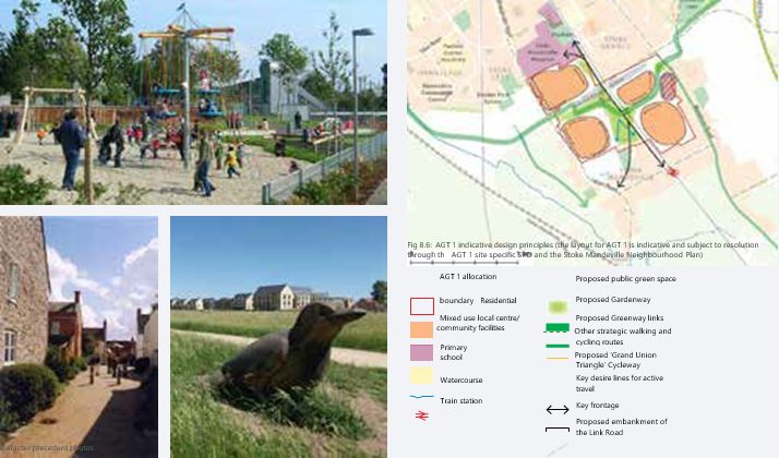
Extract from AGT Masterplan Document - Section 8.9
3.2 Development Principles and Concept
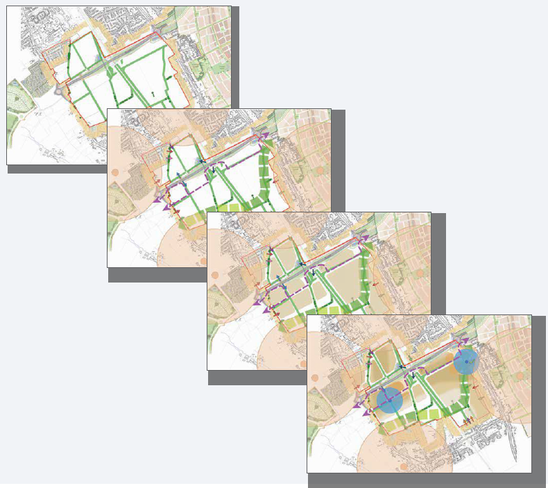
With an understanding of the contextual considerations and key opportunities as set out in chapter 2 of this Supplementary Planning Document, a series of development principles can be established which will seek to inform the Framework Masterplan for AGT1.
These development principles can be treated as a series of layers, applied in a hierarchical order which seek to apply the aspirations of the AGT1 Vision. The resulting collection of all these layers forms the basis of a concept plan around which the masterplan can be developed.
Therefore this chapter 3 'Development Principles and Concept' sets out these layered principles as follows with the combined concept plan at the end of the chapter.
These layers are set out in a hierarchical order as follows:
- Landscape New and Proposed
- ANGSt compliant green infrastructure
- Access
- Movement & Mobility
- Placement of Uses
- Character, Identities and Densities
- Concept Plan
3.2.1 Landscape New and Proposed
As an overall principle, the AGT1 development will seek to retain and improve the existing landscape resources within the site, whilst introducing new features as part of a site-wide green ANGSt compliant infrastructure network. It will seek to provide a variety of landscape treatments that respond to the character of, and strategy for, the Southern Vale Landscape Character Area whilst providing a range of public benefits.
In particular, the development framework will respond positively to the existing hedgerow, watercourse and Public Right of Way connections the basis of the AGT1 landscape structure, responding to the published landscape strategy and building upon their existing character and connectivity. This will include the creation of new areas of trees and woodland, the planting of native black poplar adjacent to watercourses and the rejuvenation of existing hedgerows. This landscape structure will then go on to inform an overall landscape-led masterplan for the scheme.
In line with Aylesbury Garden Town policy requirements, the AGT1 development will comprise 50% ANGSt compliant green infrastructure, which will take a variety of forms. This will include measures to address the identified landscape sensitivities and in particular, the important views to and from Coombe Hill and the wider Chilterns Area of Outstanding Natural Beauty.
The landscape character of the site is negatively affected by the main line railway, which strongly divides it into eastern and western parts, and this sense of division will be intensified by the delivery of the South-East Aylesbury Link Road strategic highway connection, which will run through the northern part of the site. Opportunities will be sought, however, to improve the landscape contribution of the edges of these routes.
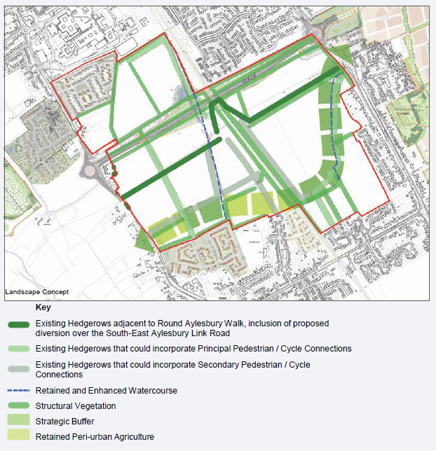
Landscape Concept
3.2.2 ANGSt compliant green infrastructure
In line with the requirements of Policy D-AGT1, the site will provide a high quality built and semi-natural environment with 50% ANGSt compliant green infrastructure by area, as with all other Aylesbury Garden Town developments. The green ANGSt compliant infrastructure will be relevant to the development permitted and needs of its occupiers and be reasonably related to its scale and kind, as required by Policy I1, which also requires it to meet the ANGSt standards contained in Appendix C of the Vale of Aylesbury Local Plan (VALP).
The overarching principles for the site's ANGSt compliant green infrastructure network, as agreed with stakeholders, are for it to be multi-functional to ensure the delivery of a range of environmental services across the network. These are anticipated to include the following:
- Public recreation and healthy lifestyles;
- Sustainable access;
- Ecological habitat;
- Sustainable drainage;
- Soil conservation;
- Carbon sequestration;
- Local food production;
- Water quality; and
- Air filtration.
In addition, the ANGSt compliant green infrastructure network will facilitate the development achieving a biodiversity net gain, as required by emerging legislation.
There is a policy requirement within the Local Plan for a buffer between the new development and the existing village of Stoke Mandeville. This will be achieved by a combination of new public open space creation within the site, and the retention of areas of existing pastoral farmland on the village edge.
The public open space component of the buffer will be variable in character according to its location with public accessibility and water as a unifying feature. A watercourse will provide a sense of natural separation of the areas to the north and south, as well as habitat diversity, sustainable drainage and natural and formal play opportunities. In the eastern part of the buffer, this will be based upon an existing brook that runs between agricultural fields.
The buffer will contain scattered trees and woodland blocks along its length, which will not only serve to increase its presence and visual interest but will also serve to filter inward views from Coombe Hill, combining with street trees throughout the scheme.
The western part of the buffer will also incorporate more formal recreation facilities, such as playing fields and equipped play. This location will enable these facilities to be shared between existing and new residents via the existing public footpath connection into Stoke Mandeville. Parts of the strategic buffer to the west of the railway line will include Peri-urban agriculture, being retained pastoral farmland on the edge of Stoke Mandeville. The requirements of Policy NE2 should be adhered to in the buffer design.
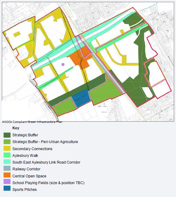
ANGSt Compliant Green Infrastructure Plan
3.2.3 Access
Vehicle Access
Potential vehicle access to the site will be taken from various points, as shown on the adjacent diagram.
Access to the land to the west of the rail line will be achieved from a new access on Lower Road. An additional access off Lower Road just north of the SEALR Lower Road roundabout would be capable of facilitating some development north of the South-East Aylesbury Link Road. Options for crossing the South-East Aylesbury Link Road into the northern parcels are being assessed by the Consortium members alongside Buckinghamshire Council. These include the potential for either a bridge or underpass of the South East Aylesbury Link Road, both of which will be subject to further assessment.
As required by the Vale of Aylesbury Local Plan the creation of the South-East Aylesbury Link Road will not leave the northern parcel unable to be accessed for development.
Access from the South East Aylesbury Link Road will not be supported unless it can be demonstrated that this would leave parcels of land inaccessible and incapable of development. Were access from the South-East Aylesbury Link Road required, a 'left in, left out' option would be explored through the planning application process.
The land to the east of the rail line would take vehicular access from Wendover Road. The precise location and details of the access arrangements from Wendover Road would be considered in detail at the planning application stage. A smaller access point taken from Castlefields on the eastern side of the site may be able to serve a small collection of new dwellings, but would not be connected to the wider street network in the site except by way of potential pedestrian/cycle links.
Emergency Access points have been considered and proposed adjoining with Carters Rise, and if not possible due to land ownership matters then potentially from Dorchester Close.
The precise location of the access arrangements will be considered at planning application stage.
Pedestrian and Cycle Access
Potential pedestrian and cycle access points into the site from the surrounding land have been considered and are illustrated on the adjacent diagram in three categories:
- Existing Public Rights of Way
- Potential links that would require third party agreement
- Potential links that will not be considered due to emerging constraints
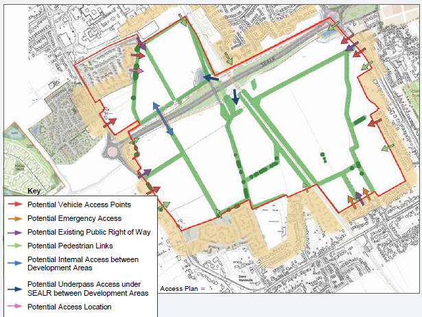
Access Plan
North-west - The Crest Nicholson scheme is currently being constructed; this has been designed to be outwardly facing along the eastern boundary therefore allowing for potential connectivity into the northern part of AGT1. Opportunities for achieving a connection point should be reviewed at application stages, subject to agreements with landowners outside of the Consortium. A Public Right of Way crosses this part of the site providing connection to Stoke Mandeville Hospital.
South-west- There are two existing Public Rights of Way entering the site in the south western area - one from Lower Road and another from land to the south. A strategic walking and cycling route between Stoke Mandeville Stadium and the railway station is being considered by Buckinghamshire Council, which would pass along the eastern boundary and access through the southern boundary of AGT1 should allow for this. Potential options include linking with the new development off Eskdale Road. There are also Parish Council owned playing fields and access to these should be reviewed at application stage.
North-east- Housing within the Elm Farm development to the north has been designed to be outwardly facing towards the boundary and potential access into AGT1 could be available. However due to the alignment of the new South-East Aylesbury Link Road connections with the main site are no longer possible. There is an existing Public Right of Way entering the site from Wendover Road to the east.
South-east - There is an existing Public Right of Way entering the site from Dorchester Close which will be utilised to provide access to Stoke Mandeville Station to the south. There is a connection point on the eastern boundary from Castlefields, and also to Petersfield which would require third party agreement.
3.2.4 Movement & Mobility
A network of routes that can be established through AGT1 should be developed to link the potential access points as set out in the preceding section. Desire lines have been established that seek to link key destinations around the site utilising the access points identified and crossing the site in a direct manner.
Key destinations in the immediate surrounding area are identified as:
- Stoke Mandeville Hospital, Stadium and local centre;
- Stoke Mandeville Village and Rail station;
- AGT4 and its new facilities – local centre and schools;
Key to the success of these links is the manner in which they cross the 'barriers' of the railway line and the South-East Aylesbury Link Road. Further guidance and aspirations for these crossing points is given in section 4.
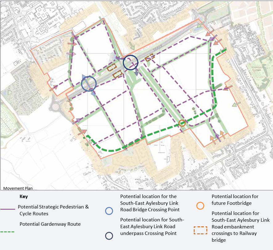
Movement Plan
3.2.5 Gardenway
The new circular route around Aylesbury is intended to be accessible for non- vehicular modes of transport, providing sustainable connections between the various urban extensions that comprise Aylesbury Garden Town, as well as the wider countryside. Its vision is to be a high quality and tranquil route, within a naturalistic corridor for the majority of its route.
The route of the proposed Gardenway is not a policy requirement, however, consideration has been given to movement corridors that could accommodate this route in future. As part of proposed ANGSt compliant green infrastructure, it is felt the indicated desire lines allow potential options for the routing of this, subject to off-site connectivity with adjacent AGT sites and options for crossing the railway line.
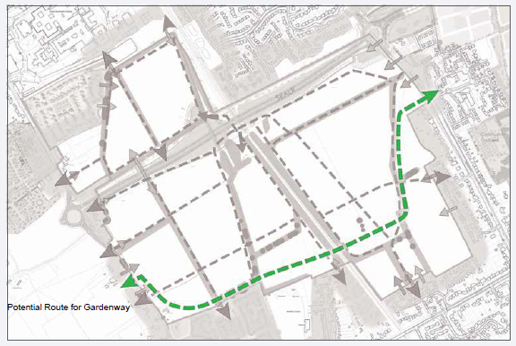
Potential Route for Gardenway
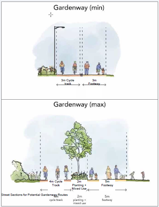
Street Sections for Potential Gardenway Routes
3.2.6 Placement of Uses
Key locations can be identified within the network of potential movement routes, that act as nodal points at key crossing locations, where infrastructure benefits can be located such as elements of the local centre, primary school, mobility hubs and community centre.
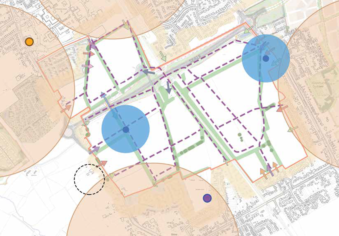
Mobility Hub + School Plan
Nodal points can be derived from the connectivity/desire lines plan, and should pick up where movement is most prominent, either within or off site. Any proposed facilities located in this area should therefore benefit from footfall and passing traffic.
By virtue of basing the key movement routes with the green corridors through the site, this should enable these facilities to be directly accessible within the immediate area via sustainable walking and cycling routes.
Three such points are derived from the studies:
- East of the railway– a location adjacent to the main access that can gain benefit from visual connections with passing traffic along Wendover Road along with a key location with the landscape framework at the head of the strategic buffer;
- West of the railway – at a central location where the east to west movement crosses with north-south movement from the South-East Aylesbury Link Road underpass to Stoke Mandeville Village to the south.
- Stoke Mandeville Parish Centre – a third location has been discussed to reflect the potential location for the Stoke Mandeville Parish Centre. The Neighbourhood Plan is suggesting this could be located on the western side of Lower Road, and as such any infrastructure within AGT1 be located adjacent to help strengthen this area.
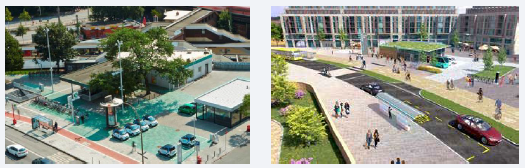
As such the Framework Masterplan should review potential locations for Local Centre and facilities within this which are located to suit these nodal points. These locations could also incorporate 'Mobility Hubs' which would offer a range of sustainable transport options for residents within AGT1 or people passing through.
3.2.7 Development Area and Character
Development Area
Overlaying the landscape strategy outlined in section 3.2.2 with the base constraints and opportunity plans create a series of potential areas of development within AGT1, each segregated from one another by an existing or proposed element of infrastructure. These infrastructure 'barriers' present challenges in terms of placemaking and connectivity, however do assist the potential application of character across the site by creating four distinct areas of development, each of which could have a differing character.
The development areas can be characterised as follows:
- Area 1 (Northern Area)– separated from the rest of AGT1 by the South-East Aylesbury Link Road;
- Area 2 (Western Area)– enclosed by Lower Road, South-East Aylesbury Link Road, railway line and strategic buffer;
- Area 3 (Eastern Area)– enclosed by Wendover Road, South- East Aylesbury Link Road, railway line and strategic buffer;
- Area 4 (South-East Area)– separated from rest of AGT1 by the strategic buffer;
The movement routes and creation of nodes suggest where development could be intensified within these areas, and edges adjoining existing context will require consideration to reflect the adjoining character. Likewise, consideration is required where edges face open spaces or 'barriers' such as the railway or South- East Aylesbury Link Road corridor.
Note this diagram and the concept plan in section 3.3 indicates these areas in full however these would be subdivided further by internal residential streets and smaller areas of open space such as pocket parks.
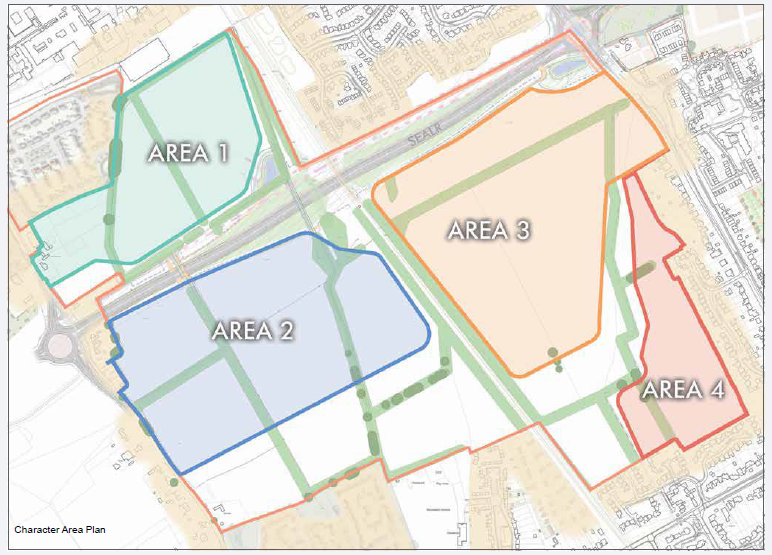
Character Area Plan
Density
Different building typologies play an important role in providing an area with character. As such, the masterplan for AGT1 should outline where differing densities are appropriate and where they can actively help provide character and identity to the new development. Common terminologies for the description of density are lower, medium and higher density, and these could be proposed within the Framework Masterplan. There are varied examples of these different types of densities in the area around the AGT1 site;
A description of the setting of each of these areas, and potential guiding principles that could be considered are shown on the following page.
|
LowerDensity |
Medium Density |
Higher Density |
|
|
Density(dph) |
approx. 25-29dph |
approx. 30-39dph |
approx. 40+dph |
|
Building types |
detached building typologies |
Predominantly semi-detached and terraced houses, with some detached houses and some small scale apartment buildings |
predominance of linked building typologies such as apartments and terraces |
|
Building heights |
generally up to 2 storey building heights |
generally 2 and 2 ½ storeys in height, allowing for some increase in height to 3 storeys in key locations |
Generally taller buildings then located elsewhere; In the local area 3-4 storey buildings can be found |
|
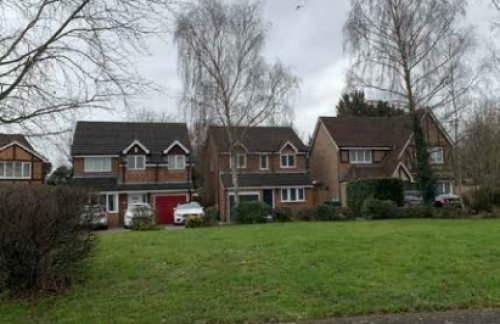
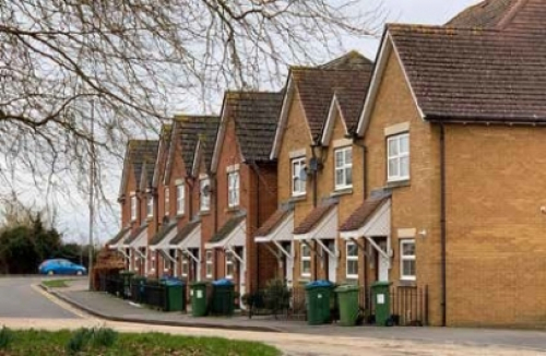
Lower density housing on Carters Ride - approx. 24dph |
Medium density detached housing on Silver Birch Way - approx. 38dph |
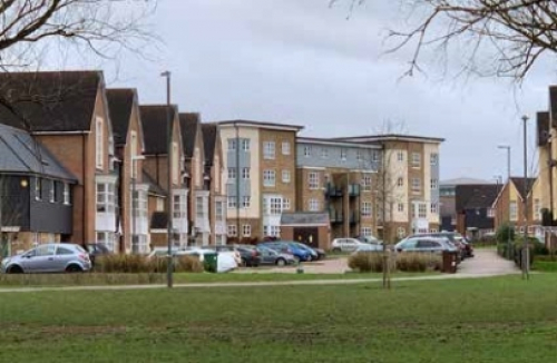
Higher density housing on Stadium Approach - approx. 60dph |
Character
Key to identifying character is the aspiration of the AGT1 Vision to complement the context against which the new neighbourhood will emerge; but also to be distinguishable where appropriate in order to establish a clear identity and character for the new neighbourhood.
As such the four development areas could each take on a role to apply this objective. Areas 1 and 4 should respond directly to the surrounding areas; Areas 2 & 3 are set apart from adjacent settlement edges and therefore, whilst incorporating characteristics common with the outer Areas, this character could be strengthened in these areas to a more distinguishing feature/aesthetic that could then provide a potential identity for AGT1.
A description of the setting of each of these areas, and potential guiding principles that could be considered are shown below.
Area 1 (Northern Area)
Guiding principles for the development of this character area are as follows:
- Surrounded by built form west, north and east;
- Adjoining development generally faces outwards towards boundaries;
- Vehicle access to be confirmed; pedestrian/cycle access to north and under the South-East Aylesbury Link Road;
- Development character perceived as extension of surrounding typologies but set within landscape framework - similarities of setting to new adjacent development;
Area 2 (Western Area)
Guiding principles for the development of this character area are as follows:
- Adjoin and will provide consistent frontage to Lower Road;
- Elsewhere separated from surroundings by the South-East Aylesbury Link Road, railway, strategic buffer;
- Development to outwardly face onto these edges;
- Opportunity for denser area within centre and at confluence of routes around nodal points;
- Potential location for Local Centre uses such as Primary School at central crossing point of routes and increased density to support this;
- Distinctive character for this parcel being separated from other development areas.
Area 3 (Eastern Area)
Guiding principles for the development of this character area are as follows:
- Generally separated from surroundings by the South-East Aylesbury Link Road, railway, strategic buffer;
- Development to outwardly face onto its edges;
- Opportunity for denser area within centre and at confluence of routes around nodal points and onto Wendover Road;
- Potential location for Local Centre uses such as retail floor space at Wendover Road frontage and increased density to support this;
- Distinctive character for this parcel being separated from other development areas.
Area 4 (South-East Area)
Guiding principles for the development of this character area are as follows:
- Seen as an extension to the existing settlement and forming a link in townscape (rather than a gap) to the existing settlement on Wendover Road and Dorchester Close/Walnut Close.
- Opportunity to form new northern edge of Stoke Mandeville Village facing towards new strategic buffer within AGT1 site;
- Similar 'feathered' outwardly facing edge to that emerging north of village to west of railway;
- Potentially lower density in sensitive locations and at southern end of buffer;
- Opportunities for 'clusters' of development within existing field boundaries and therefore landscape influenced area.
3.3 Response to Placemaking Challenges
Combining all of the layered principles as set out within this chapter and outlined in 3.2 produces a Concept plan, upon which a framework masterplan can be developed. This Concept plan should respond to the placemaking challenges outlined in section 2.3 and meet the aspirations of the AGT1 Vision as follows:
Landscape – A landscape framework that maintains and enhances existing vegetation and Public Rights of Way; incorporation of a green buffer to maintain the setting of Stoke Mandeville village including retained pastoral land to retain elements of the existing rural character and provide a soft transition;
Connectivity– movement routes direct within sub-areas of AGT1, and directed towards potential crossing points of the 'barriers' that dissect the site;
Settlement – development areas should be established by the landscape strategy and therefore respect adjacent settlement edges; settlement identity to be created through an understanding of the surrounding characters;
Identity– opportunities to reflect the individual identity of Stoke Mandeville village and south Aylesbury, whilst forming a known identity for AGT1 in the more central areas of the development;
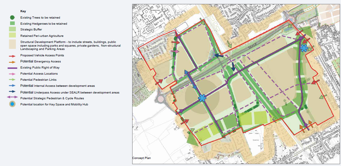
Concept Plan


