RAF Halton SPD
PART 1 – THE DEVELOPMENT FRAMEWORK
1. Introduction
1.1. Background
This Supplementary Planning Document (SPD) provides guidance that builds on the requirements of Policy D-HAL003 in the adopted Vale of Aylesbury Local Plan (VALP), a copy of the policy is set out in full in Appendix 1. The SPD provides further detail to the policy requirements and sets out a series of key design principles and guidance to support the delivery of a high quality development, that is sensitive to the site's historic and environmental setting.
RAF Halton is allocated within the Vale of Aylesbury Local Plan (VALP) for at least 1,000 dwellings over the period 2025-2033, together with associated infrastructure and facilities, including a primary school, local centre, community hall and new access routes. The policy requires the conservation and enhancement of heritage assets and their setting whilst ensuring viable uses consistent with their conservation, and the retention of existing sports facilities on the site for use by new and existing residents. RAF Halton is currently a RAF training base and it has been confirmed that it is to close and be decommissioned by the Defence Infrastructure Organisation (DIO); the current timetable for closure is 2027. The allocated site comprises 82 hectares, and is located entirely within the Green Belt.
Figure 1 shows the site's location and wider context south-east of Aylesbury Garden Town, and on the edge of Wendover and the Chilterns Area of Outstanding Natural Beauty (AONB). Located immediately east of the village of Halton, and lying within Halton Parish, the site's character today reflects its history as a RAF base which is to be respected and referenced in its redevelopment. The site contains a number of designated and non- designated heritage assets including listed military accommodation buildings. World War 1 training trenches and a former railway line lie just outside of the allocation. It has a mature landscape and sports facilities which are to be incorporated as part of the development. The listed Halton House and its associated Registered Park and Garden of Special Historic Interest lie immediately to the north, and partially over the north-west corner of the allocated site, and the site is wrapped around to the north-east and east by Wendover Woods.
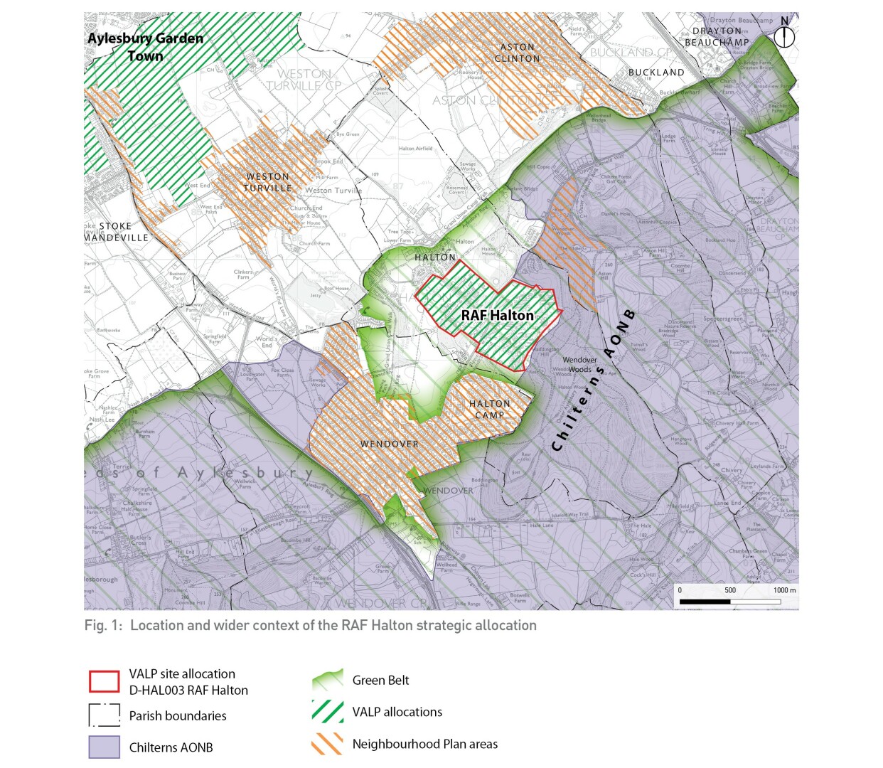
Fig.1: Location and wider context of the RAF Halton strategic allocation
1.2 Purpose and status of the SPD
The SPD provides guidance about how the redevelopment of the RAF Halton allocation should be designed and delivered in the context of VALP allocation Policy D-HAL003 and other relevant polices in the Development Plan, including VALP Policy D1, Delivering Aylesbury Garden Town, with which proposals for the redevelopment of RAF Halton are expected to comply. The SPD cannot create new policy and its scope is limited to the land within the policy allocation.
Shaped by the outputs from engagement with a wide range of local stakeholders including Halton Parish Council, adjoining parish councils, Buckinghamshire Council members and officers and the representatives of the Defence Infrastructure Organisation (DIO), the SPD sets out a Vision and overarching set of design principles for the site. It identifies the main land uses and infrastructure to be accommodated on the site and a thematic approach to addressing the key structural elements, including landscape, heritage and movement. Key areas that the SPD addresses include:
- How best to retain existing features of significance and appropriately reference the site's military and cultural heritage while creating an attractive and legible residential neighbourhood;
- The potential for the site to support the health and wellbeing of local people, building on the site's proximity to the AONB, opportunities for walking and cycling, and retention and enhancement of sports facilities;
- The creation of a strong landscape structure for the development, with green infrastructure accounting for 50% of the site area, focussing on the existing mature landscape of the site and connecting this with the surrounding AONB and wider landscape which is protected by Green Belt;
- Agreeing the most appropriate location for the primary school and local centre to provide a heart to the development, in a highly accessible location;
- Connecting the development with Wendover and integrating with Halton and via strategic walking and cycling routes with Aylesbury Town Centre, supporting the ambitions of the Aylesbury Garden Town Masterplan and encouraging active travel.
- How to deliver at least 1000 homes, as required by Policy HAL003
The SPD does not define the precise location and extent of all land uses and infrastructure items; that level of detail will be defined through future planning applications. Alternative solutions and land use arrangements that are different to those within this SPD could come forward as part of the planning application process, but applicants should explain the reasons for any significant differences in approach.
The SPD has been prepared according to the Town and Country Planning (Local Planning) (England) Regulations 2012 (as amended) and, once adopted, will be a material consideration in the determination of planning applications on the site.
1.2. Structure of the SPD
The SPD is structured to support the relevant local plan policies and support the future preparation and determination of planning applications as follows:
PART 1–THE DEVELOPMENT FRAMEWORK
- Section 1 – Introduction
- Section 2 – Vision and objectives
- Section 3 – Key Principles and the Development Framework
- Section 4 - Delivery Strategy
PART 2 – BACKGROUND INFORMATION
- Section 5 – Policy Context
- Section 6 – Site Context
- Section 7 - Summary of Constraints and Opportunities


