RAF Halton SPD
2. Site context
Location and surrounding land uses
The site lies to the south east of Aylesbury Garden town, north-east of Wendover and forms part of the area of Halton Parish. The site is adjacent to the Chilterns AONB and sits at the foot of the Wendover Woods.
Figure x: location of the RAF Halton strategic allocation
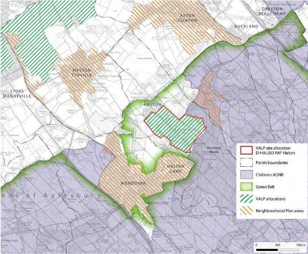
The majority of the site is currently owned by the MoD and is an operational RAF training base comprising barracks, staff accommodation and supporting facilities including a church, children's nursery, health and leisure facilities.
An area adjacent to Upper Icknield Way is owned by Buckinghamshire County Council and is used for the County Museum Resource Centre.
The existing character of the site can be broadly classified as:
1. Groves and Henderson barracks in the north east of the site. This area forms the earliest remaining barracks buildings of up to 3 storeys and parade ground which are listed, set adjacent the wooded hillside of Wendover Woods. It feels relatively separate to other parts of the site and has a distinctive formal 'set-piece' character arranged around the large tarmacked parade ground.
2. Maitland Barracks in the south east of the site, to the east of Upper Icknield Way. This comprises slightly later barracks buildings of up to 3 storeys and supporting facilities. The area has a loose, urban form with large areas of lawn and a second hard surfaced parade ground. The character is less formal, and more fragmented reflecting its gradual development. The central section slopes up to an upper plateau abutting Wendover Woods, enabling long distance views west over the Vale of Aylesbury.
3. South of Chestnut Avenue. This area has a lower density urban form comprising large footprint buildings of 1-2 storeys with large lawns and car parks between. Historic workshops occupy a central location and are in a poor state of repair. Buildings are set back from Upper Icknield Way and the mounted jet is a local landmark.
4. To the south west of Chestnut Avenue, grassed sports pitches, an astro turf pitch and courts are served by the Nuffield Pavilion which is a distinctive landmark building.
5. To the north of Chestnut Avenue, there are a series of building complexes of up to 3 storeys, including the Kermode Hall and St Georges Chapel, interspersed with a parkland landscape and woodland which is a remnant of the Halton House estate and partially within designated Registered Park and Garden. The existing development has a poorly defined relationship with the Park and Garden.
History of RAF Halton site
Formerly monastic land, the site became part of the Dashwood-King estate in 1720, and was a self- contained agricultural community. Baron Lionel Rothschild purchased the estate in and was then absorbed into the Rothschild estate in 1853. Halton House, which lies just outside of the strategic allocation was built in 1883 together with the creation of the Grade II historic parkland and many of the houses in Halton village were built for staff of the Rothschild estate, and have a distinctive design Marking a change to the character and use of the estate, In 1913 to support the war effort, the estate was loaned to Lord Kitchener as a training establishment, including training trenches, which remain today, and was then sold to the crown in 1919. The estate was developed to provide workshops and barracks, including the Groves and Henderson barracks which are now listed buildings. The site became RAF Halton, with hangars and an airfield to the north of the village, outside of the site allocation.
The base expanded incrementally in the 1920s. The Grove and Henderson Barracks date from this period. (Text taken from DIO Vision and Halton Parish documents)
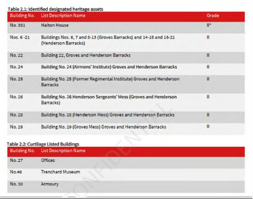
Heritage Assets
Designated heritage assets on the site (aside from the scheduled Monument), relate to the site's history as part of the Rothschild Halton House estate from 1853 onwards, and subsequent use as an RAF base from the early 20th century onwards.
- Nationally Listed buildings (list taken from JLL report):
- A portion of the Site is situated within the grade II Registered Park and Garden of Halton House
- Scheduled Monument - Long Barrow located 200m east of parade ground, Groves Road, Halton Camp
- Halton Conservation Area approximately 100m to the north of the site boundary.
Non-designated Heritage Assets:
The following are being added to the local list as non-designated heritage assets (for latest list and status of buildings, see the Buckinghamshire Council Local Listing web platform: Home - Buckinghamshire's Local Heritage List (local-heritage-list.org.uk))
- Archaeological notification area covering the majority of the Registered Park and Garden and Scheduled Monument
- Heritage at risk area covering the Registered Park and Garden
Museums within the SPD boundary:
- The Trenchard Museum and James McCudden Flight Heritage Centre located in the north east of the site which display items relating to the history of RAF Halton. Open to the public by appointment.
- The Bucks County Museum Resource Centre, on Rowborough Road. This contains important collections and County archives.
The strategic allocation area includes a range of heritage assets, including:
- Grade II* and Grade II listed buildings
- Curtilage listed buildings
- The Grade II listed Registered Park and Garden of Halton House
- A scheduled ancient monument
- Archaeological notification area
- Heritage at Risk
- Conservation Areas at Halton and Wendover
- Local listed buildings
Landscape and ecology
The strategic allocation is wholly located in the Metropolitan Green Belt and on the edge of the Chilterns Area of Outstanding Natural Beauty (AONB). The site lies within two national character areas, Upper Thames Clay Vales and The Chilterns. Local Landscape designations include:
- Area of Attractive Landscape (AAL) covering the land around Halton House and up to Chestnut Road
- Local Landscape Area (LLA) covering the eastern part of the RAF Base There is significant vegetation across and adjacent to the site, including:
- Tree Avenues: three long avenues running in a north-west to south-east direction along Chestnut Avenue and between the playing fields south of Chestnut Avenue.
- shorter avenues of trees on Upper Icknield Way at the junction with Chestnut Avenue.
- Large blocks of woodland and parkland trees in and on the edges of the RAF base screen views into the base from the surrounding roads and countryside.
- Numerous smaller groups of trees and individual trees throughout the site.
- Wendover Woods and large belts of trees around Halton House and along the Grand Union Canal creating a green setting for the site.
In terms of ecology, there are areas of important both within and outside of the site:
- Weston Turville Reservoir SSSI is located approximated 330 m south west; Aston Clinton Ragpits SSSI is located c. 690m to the east; and Dancers End SSSI is located c. 970 m east
- The Allocation Site falls within several Natural England SSSI Impact Risk Zones (IRZs) for the above SSSIs
- There are 12 Local Wildlife Sites (LWS), and four Biological Notification Site (BNS) within the 2 km radius of the Site
- There is a large area of semi-natural ancient woodland which spans Haddington Hill and Wendover Woods; extends into the south eastern boundary of the wider RAF Halton, and so lies directly adjacent to the Allocation Site. There are also several small areas of semi-natural ancient woodland within the wider RAF Halton boundary and include Tops Wood; Rowborough Copse; Haddington Hill and Marl Copse (none fall within the Allocation Site).
- Priority Habitats Inventory layer also identified areas of lowland deciduous woodland, traditional orchards and wood pasture and parkland priority habitats across the Allocation Site and wider RAF Halton.
- There are several woodland parcels within the wider RAF Halton
- Multiple areas of grassland fall within the Allocation site
- A number of trees, treelines and hedgerows are present within the Allocation Site
- A number of individual trees protected by TPO are located along Chestnut Avenue to the north east of the Allocation site
- Further survey will be required to determine whether any of the trees (scattered or within woodland), constitute veteran trees, or whether any of the hedgerows qualify as 'important' under the Hedgerow Regulations.
- Local Geological site – adjacent to the allocation site
- Wendover Woods Biodiversity Opportunity Area (BOA) – covers the land to the south of listed barracks
Some of the designated habitats can be expected to support a range of protected or notable species, such as: bats, great crested newts, otter, reptiles, water vole, breeding birds, plants and invertebrates.
Movement and Access
Current Transport Infrastructure serving the site includes:
- B4009 (Upper Icknield Way) which passes through site from Wendover to Tring (connecting the A413 to A41). There is a secondary road (Chestnut Ave) connecting the site to Halton village and beyond. Both roads have a 30mph speed limit and both are single carriageway.
- Bus route 50 provides a half-hourly from the site to Aylesbury via Wendover although it doesn't connect to Wendover station (600m gap) nor to Halton village.
- The Grand Union Canal towpath and nearby Wendover Woods provide trails for pedestrians/cyclists
- There are many public footpaths close by the site, particularly to east of site. One footpath cuts through site in the west (from Halton southwards to Wendover). HAL/6/2 runs through part of the allocated site and route ACL/25/1 and HAL/3/2 run along the perimeter of the site to Halton House.
- Wendover railway station (2km away, 183 parking spaces, 104 bicycle stands) and Aylesbury railway station (7km away) provide half-hourly trains with services to Aylesbury and London Marylebone.
- There is a pedestrian and cyclist subway under B4009 within the site itself, connecting the eastern and western parts of the base.
Vehicle access to the site is available from Chestnut Avenue and Upper Icknield Way, via existing junctions and potential new junctions to be agreed with Buckinghamshire Council highways team. There is significant potential to increase sustainable travel in line with Aylesbury Garden Town objectives and an opportunity for speed reduction and traffic calming on B4009/Chestnut Avenue through good design. good design; design challenge of integrating main roads into village fabric
Flood Risk
The site is located wholly within Flood Zone 1 for fluvial flooding and at very low risk of surface water flooding.
Utilities
Electricity
- The Site is located within an area served by UK Power Networks (UKPN).
- The site's electricity supply is provided by 11kV cables located on Tringroad, which enter the Maitland/Henderson area of the site to connect to an onsite intake substation. The intake Substation is connected to a private High Voltage ring main (PHV), which supplies a network of 14No. on-site substations. These substations supply electricity to on-site buildings through a network of private Low Voltage (PLV) cables.
- UKPN have further confirmed the presence of 11kV underground cables (UGC) running from Harelane Bridge path past Church View towards the Garden Close / Chestnut Avenue intersection before going west towards the cricket ground in the northern half of the site.
- The existing high voltage 11kV ring main and Substation network on-site, will require a survey to assess their current status and viability for future utilisation. However, elements of this network and associated substations will need to be relocated/diverted to facilitate the development.
- UKPN have proposed to extend the HV network between the PoCs and around the site to the three 500kVA Substations and one 315kVA Substation. In addition, LV cables will be laid to provide connections to 1,000 dwellings with external meter cabinets.
Gas
- The Site is located within an area served by Southern Gas Networks (SGN).
- There is a network of Medium Pressure (MP) main along Halton Village Road, Chestnut Avenue, Tring Road / Upper Icknield Way and Babington Road.
- There are several spurs of MP gas supply mains entering the site at supplying some of the buildings on-site.
- There is an MP main entering the site on Stable Road to supply an on-site gas Pressure Reducing Station (PRS).
- There is a network of MP gas mains in the proximity of the site, which can be a source of gas supply. The Gas Governor in the vicinity of the site as well as the gas network will need to be assessed by SGN to understand the suitability for the future development proposal, diversions or terminating the mains at suitable joints will need to be considered as the masterplan develops.
Telecommunications
- The Site is located within an area served by Openreach.
- There is vast network of existing Openreach underground and Overhead (OH) infrastructure within and adjacent to the site.
- The respective Openreach cables run along the access roads, Halton Village Road, Chestnut Avenue, Tring Road / Upper Icknield Way and Babington Road and through runs through sections of fields.
- There is a significant network of Openreach underground cables and overhead lines in the vicinity, which may require some diversionary or protection work to facilitate the development
Potable Water
- The Site is located within an area served by Thames Water (TW).
- There is an existing potable water main which runs within Weston Road in adjacent to the development site in the north.
- There are potable water mains which run along the access roads, Halton Village Road, Chestnut Avenue, St Michaels Close, The Orchard Tring Road / Upper Icknield Way and Babington Road.
- Asset records obtained show that there are existing private on-site water networks, which will require some degree of diversion or decommissioning as a result of development.
- The development will increase potable water demand in the area. TW advised that their supply of potable water network did not have sufficient capacity to serve the full site requirement for up to 1000 properties. TW advised that they have sufficient capacity in the network to serve up to 25 properties but off-site reinforcements works would be required in order to supply the full site.
Fouland Surface Water
- The Site is located within an area served by Thames Water (TW).
- There is an on-site Sewage Treatment Works (STW) located on the south-east corner of the airfield near Harelane Bridge, which is connected to the onsite foul sewer network.
- There are existing foul and surface water network shown on-site and in the vicinity of the site. An existing foul sewer with manholes crosses the area of Halton Camp.
- All of the buildings within or adjacent to the site is connected and/or have a private foul and surface water network connection.
- Asset records show that there are existing private on-site drainage networks (foul and surface water) which will require some degree of diversion or decommissioning as a result of the development, as they may not align with the proposed corridors within the concept masterplan.
- The development will increase foul water discharge on-site.
Conclusions
- Energy and water cycle strategies need to be undertaken to understand what on-site opportunities there are to reduce demand through generation and re-use. This will help inform what, if any, off-site reinforcement is needed.
- UKPN have confirmed that there is capacity in the HV electricity network to provide the required supply for the development's initial phase of 1000 dwellings, to connect to their HV network 3 x 500kVA and 1 x 315kVA ground mounted substations with associated LV underground network to supply the properties.
- There is a network of MP gas mains within the proximity of the site, which can potentially supply the entire site. SGN have advised reinforcement works will be necessary and the need to apply for a firm quotation to provide further details for gas reinforcements.
- The Openreach infrastructure supply strategy will be affected by the construction of the development, to assess the extent of the works, Openreach will need to undertake a detailed survey.
- No direct enquiry has been made to Virgin Media (VM), VM has existing network within Tring Road and Aylesbury Road.
- Thames Water have expressed their capacity concerns for clean water supplies and will require the developer/landowner to provide proof of ownership and outline or full planning permission. This will then trigger 20 months of work by Thames Water, which will conclude in reinforcement of the network in order to supply the full 1000 new properties. If the timescale is beyond the developers first occupancy then the developer will need to underwrite the cost of modelling and design. Thames Water will fund the study but if the developer fails to achieve a connection within 5 years they will be liable for the £11K + VAT.
- There is extensive multi-utility public and private infrastructure across the site. Further surveys and enquiries will be required to assess its viability in the future development and understand the costs for diversion/termination of the existing network during the construction.


