RAF Halton SPD
3. Key principles and development framework
The redevelopment of the RAF Halton site will deliver a comprehensive scheme in line with the requirements of Policy D-HAL00s and following the principles of Aylesbury Garden Town as set out in Policy D1.
In particular, the design and layout of development will follow a landscape-led approach and will seek to address, protect and enhance the purposes of the Green Belt, setting of Halton village, the Chilterns AONB, Halton House itself and its Grade II listed Registered Park and Garden.
It will retain and incorporate existing sports facilities and conserve and enhance nationally and locally listed buildings, the registered park and garden, and the Scheduled Monument and their settings.
In line with the VALP Policies D-HAL003 and I1, at least 50% of the site area will be publicly accessible green and blue infrastructure. This will incorporate the high-quality open spaces and habitats already present on the site, including existing woodland and grassland, tree avenues, hedgerow and will create new green corridors and parkland that will link to the green infrastructure network of the wider countryside.
In addition to the policy requirements, a series of development principles have been established through the SPD process. These principles are grouped in themed layers and, combined together, form a comprehensive development framework for the site.
The development framework consists of the following themed layers:
- Overall framework masterplan
- Land use
- Landscape
- Heritage
- Movement and access
- Urban design and placemaking
- Character areas
3.1 Overall Framework Masterplan
Figure 2 illustrates how the site will deliver at least 1000 homes taking into consideration policy requirements, existing site constraints and the agreed Vision. Key features of the framework masterplan include:
- Mixed use local centre on Chestnut Avenue including the reuse of St George's Church
- New two form entry primary school with playing fields to the north east adjacent to the Registered Park and Garden
- Enhancement or restoration of the Registered Park and Garden parkland associated with Halton House
- Sports and leisure corridor incorporating the Nuffield Pavilion (which is retained for community/sports use), allotments, play space and open space comprising of existing parkland and woodland
- Retention of the old station building within a public square, and creation of an extended east-west tree-lined avenue.
- Higher density residential neighbourhood close to the local centre and fronting Upper Icknield Way and Chestnut Avenue
- There is an aspiration to incorporate relocated Trenchard Museum collections and interpretation of the nearby WWI trenches near to the existing County Museum facility.
- Traffic calming and new pedestrian/cycle crossing points on Upper Icknield Way and Chestnut Avenue to create pedestrian-friendly streets
- Improvements to the junction of Upper Icknield Way and Chestnut Avenue to enable easy pedestrian and cycle connectivity
- Listed Groves and Henderson barracks converted to residential or other appropriate use Parade ground becomes a new public park with play space and community use of the former Trenchard Museum along with potential for vehicle parking space.
- Natural parkland and grassland habitat with enhanced walking/cycling access to Wendover Woods
- North-south green corridor of parkland and play space with views over Aylesbury Vale
- Moderate and lower density residential development of Maitland barracks and upper parade ground, including conversion of locally listed buildings
- Former stables and cinema buildings could both be converted to either community or leisure use within a parkland setting should they not be suitable for conversion to residential. They could be converted to non-residential uses such as a cycle hire hub, co-working hub café.
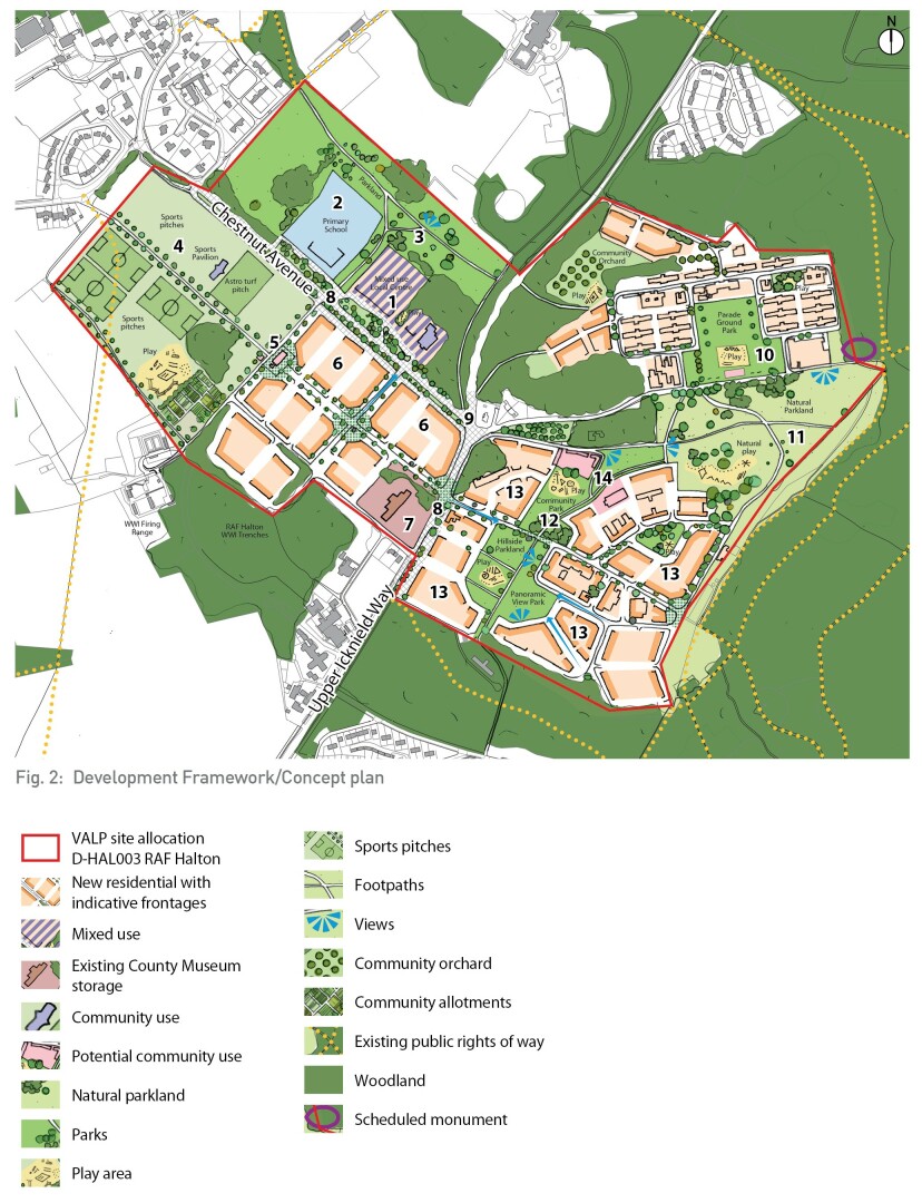
Fig. 2: Development Framework/Concept plan
3.2 Land use
Previously developed land
The site is currently an operational RAF base and with around 50% of the land area occupied by existing buildings, roads and footpaths, car parking and hardstanding areas, including the hard and soft curtilage of the developed land, which jointly are described as 'previously developed land' or PDL. In line with paragraph 141 of the NPPF and the site's Green Belt designation, the re-development of PDL should be prioritised.
Nearly 50% of the site is currently undeveloped, as follows:
- Sports: ~8 ha
- Woodland: ~11 ha
- Grassland: ~5 ha
- Other open space: ~15 ha
Areas of previously developed land and undeveloped areas are identified on Figure 3.
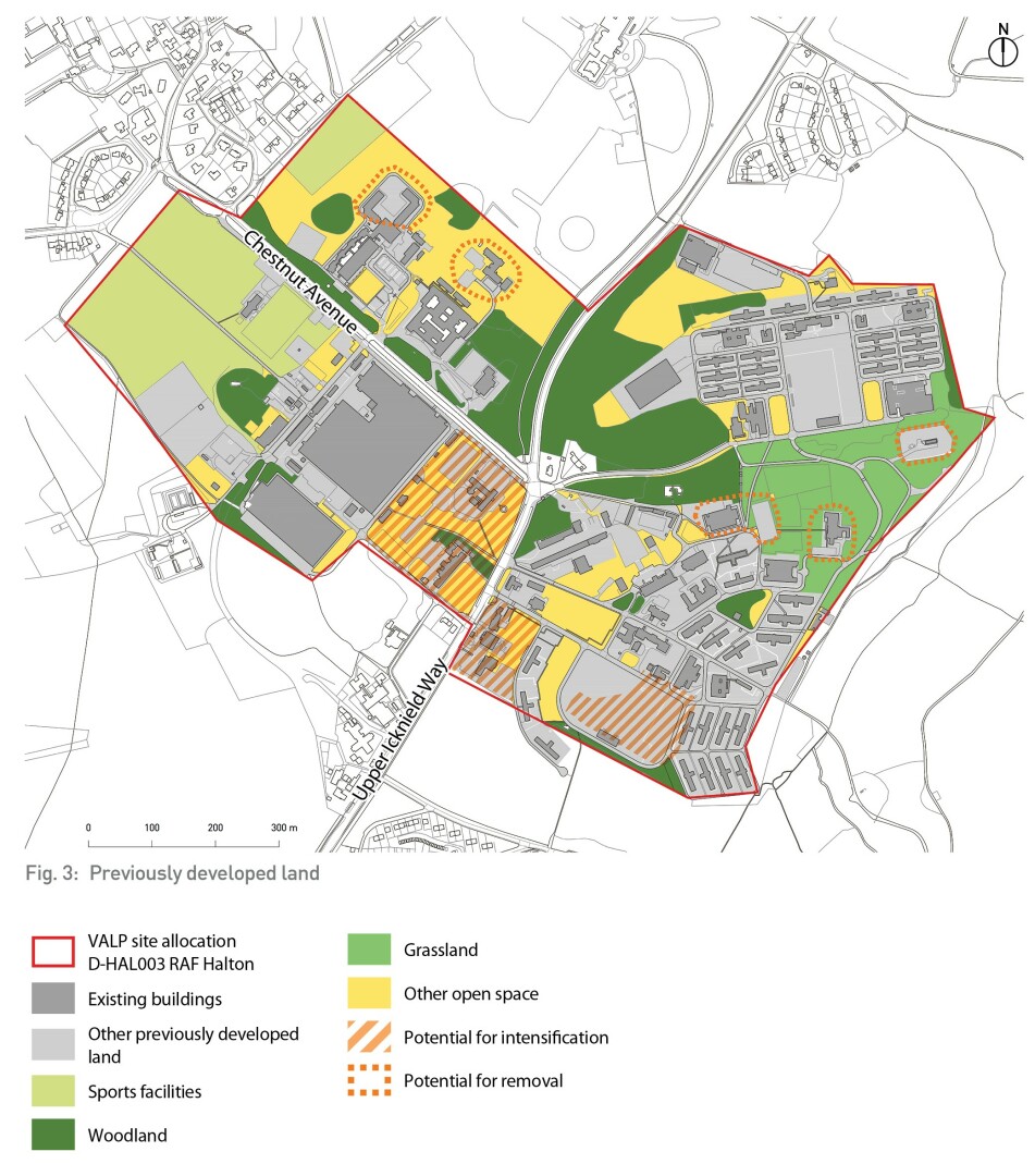
Fig. 3: Previously developed land
Land Swaps
Informed by the stakeholder consultation process, the Council has agreed in principle to the potential for land swaps between PDL and undeveloped land within the allocation boundary. This is intended to strengthen the aims and purposes of the Green Belt, and improve the spatial and visual openness of the site by enabling efficient development blocks, improving the openness of green spaces and enhance and better connect green infrastructure including the enhancement of the Registered Park and Garden.
Any proposed land swaps should deliver clear placemaking and landscape benefits, and not have a greater impact on openness of the Green Belt than the existing development.
The overall quantum of high-quality green infrastructure should be retained and ideally increased as a result.
At planning application stage, ecological surveys are required to identify areas of significant ecological and biodiversity value which should be protected and excluded from any land swap proposal.
Land swapping development principles:
- Consolidate green space and reduce outlying development to enhance purposes and openness of the Green Belt, create green corridors, deliver ecological and placemaking benefits and enhance the Registered Park and Garden and its setting.
- Intensify development in central locations by increasing the development footprint on identified areas on the site (specifically the warehouse area).
- Introduce development on part of the existing Maitland Parade Ground which is currently hardstanding.
- Overall, retain at least 50% of the site area as high-quality green infrastructure.
Proposed land uses
Building on the requirements of Policy HAL003 and the outcomes of stakeholder engagement in the preparation of the SPD, the development site should provide the following land uses:
- Residential (Use Class C3, Dwellinghouses and potential for Use Class C2, Residential Institutions): at least 1,000 dwellings on approximately 30 hectares including new-build homes and converted heritage assets.
- Green space: at least 41.5 hectares of green and blue infrastructure including the retention of existing sports facilities, new play space, allotments and community orchard, parkland, walking and cycling trails, and woodland and grassland habitat.
- Mixed-use local centre (includes Use Classes A and D1 (non-residential institutions) occupying around 3.4 hectares of land, including 1.7ha of land (excludes drop off area) for two form entry primary school and 60 place pre-school
The proposed land uses are illustrated on Figure 4.
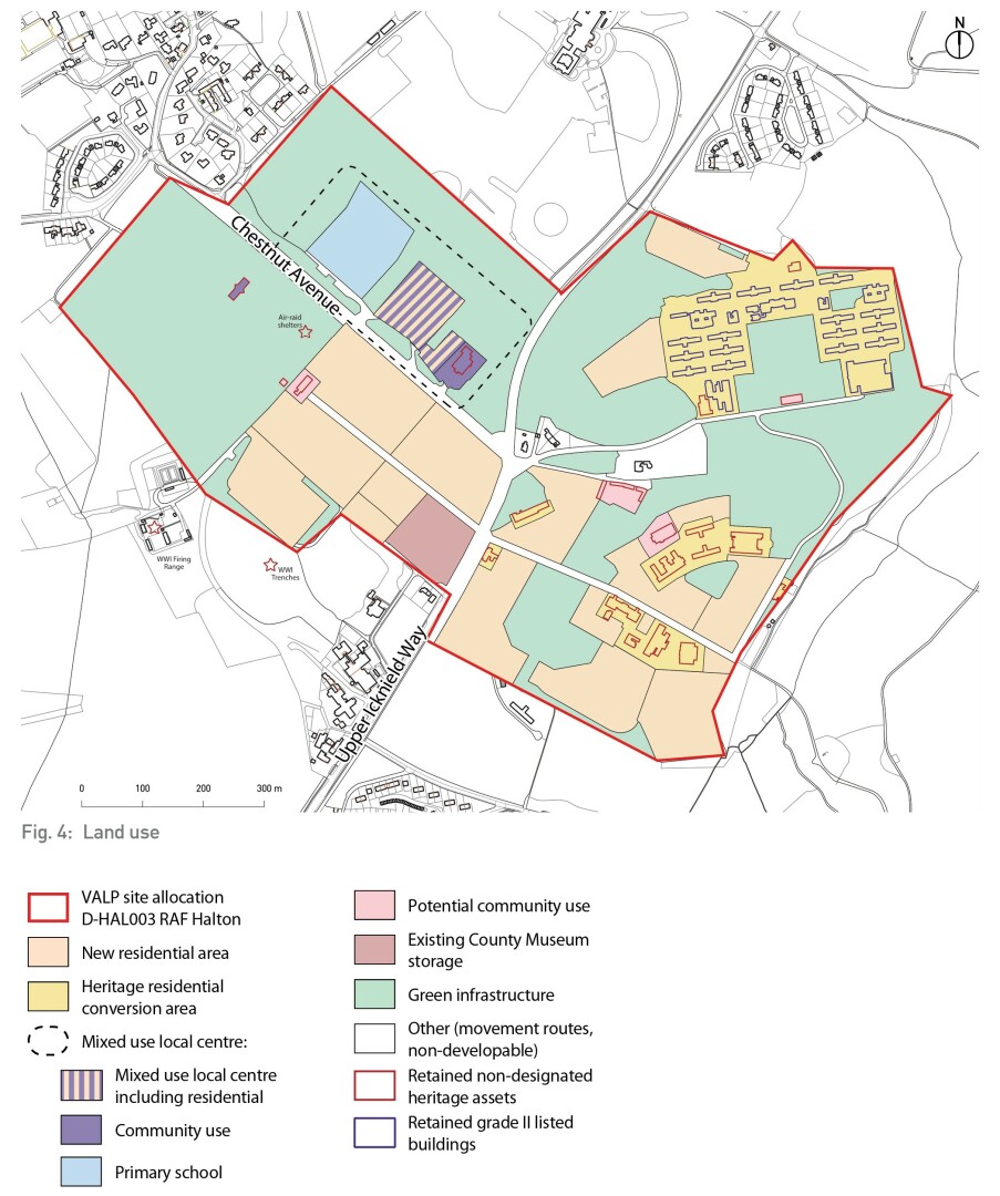
Fig. 4: Land use
Community facilities
Local facilities are to serve both the existing residents of Halton village and those of the future new neighbourhoods within the site. The new local centre, school and community hall should be co- located and be situated to the north of Chestnut Avenue, this enables the provision of facilities in a central location relative to the new development, the wider Halton Parish and within a 10 minute walk of Halton's residential areas. This is in line with the principles established for local centres in the Aylesbury Garden Town Masterplan section 4 'Local Centres'.
The location of the primary school and local centre will also enable a close relationship between the school, local centre, and the Nuffield Pavilion and the existing sports facilities. Together this hive of activity will form a community focus in the centre of the parish of Halton easily accessible on foot and by cycle/ wheeled travel. Any traffic calming proposals for the Chestnet Avenue area should consider the dual aims of the scheme: to allow access to the local centre and school whilst simultaneously reducing the potential for additional vehicle movements down Chestnut Avenue and further afield.
Figure 5 identifies the location of the community facilities on the site as well as a number of buildings which are non-designated heritage assets whose future use could include community space or other non-residential uses. Figure 6 demonstrates the central location of the local centre within the wider parish area.
Local centre development principles:
The new mixed-use local centre will support the following development principles and should:
- be of a scale similar to other nearby centres (for example those within Aylesbury Garden Town), which could offer essential facilities and businesses comprising around 1,500 sqm to 2,000 sqm of total floorspace for essential retail, food and drink, small scale business or homeworker hub and non-retail services such as post office, healthcare, parcel collection points, cycle repair. (VALP Policy D7 and AGT Masterplan section 5.4);
- retain and reuse St George's Church as a new community hall;
- where possible, retain and integrate the frontage of Kermode Hall, and other existing buildings;
- incorporate residential uses including on upper floors, and potentially including specialist older persons accommodation;
- provide a play space and high quality public realm;
- where traffic calming measures are introduced, these should have two aims – to allow access to the local centre and school whilst also reducing the potential for through traffic vehicle movements along Chestnut Avenue and to the wider area;
- provide opportunities for shared car parking facilities between the sports facilities the school and local centre;
- have the potential to function as a mobility hub;
- enhance the Registered Park and Garden and its setting.
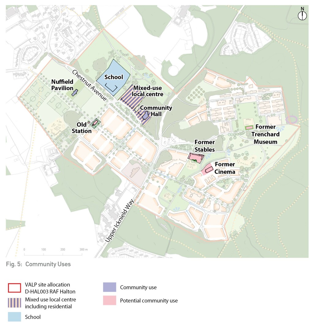
Fig. 5: Community Uses
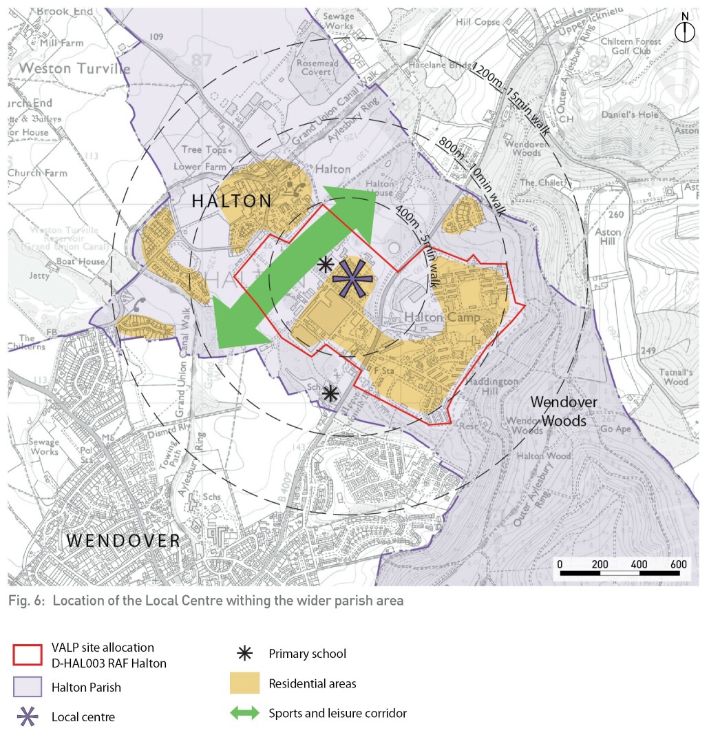
Fig. 6: Location of the Local Centre withing the wider parish area
Primary School
The location of the new 2 form entry primary school (and 60 place pre-school) is identified to the north of Chestnut Avenue adjacent to the proposed local centre. The new school site will be delivered in line with Buckinghamshire Education Standards and will require a provision of:
- School buildings, outdoor playground and playing fields
- Pick up/drop off area
- Off street parking for staff
Primary School Development Principles:
Pedestrian and cycle access to the school is to be encouraged through the provision of safe, direct and legible walking routes to schools and pedestrian crossings of Chestnut Avenue in the vicinity of the school and through the subway under Upper Icknield Way. Cycle/scooter parking is to be provided within the school site. Facilities should be provided for staff to encourage walking and cycling, including secure bike parking, shower and changing facilities and lockers.
Access and egress for cars and servicing vehicles will be from Chestnut Avenue and is to be designed in conjunction with the traffic calming of Chestnut Avenue, to minimise the impact of school related trips.
There is a preference for coaches/buses to enter the site, however coaches/buses could enter and exit via the existing service road in front of Kermode Hall. A satisfactory scheme without buses/coaches entering the site could therefore be considered. Larger service/refuse vehicles may be required to enter the site and these vehicles should be able to manoeuvre as easily and safely as possible.
The primary school site is surrounded by the Halton House Registered Park and Garden (RPG) and the access between the school site and the road lies within the RPG itself. The design of the school and its wider site should seek to enhance the RPG and its setting.
Other community uses
In addition to the school and local centre, the development framework identifies opportunities for other community /small scale retail or commercial facilities across the site, through conversion of the following heritage assets:
- Former stables block
- Former cinema building
- Former station building
- Trenchard Museum building
These buildings are located on the edge of proposed public parks and could provide supporting non-residential facilities such as community meeting space, mobility hub, cafes, small business space or childcare.
3.3 Green & Blue Infrastructure
RAF Halton has a distinctive, high quality landscape setting which is a core aspect of its character and sense of place.
The redevelopment of the site is to be landscape-led retaining at least 50% of the site area as a multi-functional network of public green spaces and habitats, which together contribute to the openness of the Green Belt. Trees, grassland, sports pitches, and Registered Park and Garden within the site are to be retained and enhanced to form a mature and highly attractive green setting for the proposed residential neighbourhoods and local centre. Figure 7 illustrates the proposed landscape strategy for the site.
Biodiversity Net Gain (BNG) of at least 10% is to be delivered on site, in line with the adopted Biodiversity Accounting SPD. The grassland and parkland drive area should become a focus for BNG but it will also apply over the whole site area.
Landscape principles:
- Existing woodlands and grassland will be retained, improved and expanded for biodiversity value, with appropriate buffer zones to development. Minor localised losses of low-value grassland/trees may be allowed where it can be demonstrated that, on balance, it would deliver significant benefit to the new site layout and placemaking.
- existing high-quality hedgerows and trees and drainage corridors are to be integrated into the overall layout within green infrastructure corridors
- the Registered Park and Garden associated with Halton House will be enhanced through the removal of outlying buildings
- play space is to be located in green spaces serving all parts of the site, and is to be designed for universal access
- Sustainable Drainage System (SuDS) features will be integrated into existing and all appropriate proposed green spaces and residential areas, providing semi-natural habitat value alongside surface water flood mitigation
- new pedestrian and cycle access points to the existing woodlands within the site and to Wendover Woods are to be provided
- detailed landscape proposals for the site should take account of the existing landscape and heritage designations:
- Green Belt setting
- Area of Attractive Landscape
- Priority Habitat
- Local Wildlife Sites
- Local Landscape Area
- Biodiversity Opportunity Areas
- Scheduled Monument
- Registered Park and Garden
Landscape features
The landscape strategy for the site delivers the following green and blue infrastructure features; the number of each feature corresponds to the numbered areas on Figure 7, Landscape Strategy:
A new community park is proposed within Groves and Henderson Parade Ground. This will comprise a green open space and central square with a formal character. The landscape design should reinforce the area's formal military character and history, enhance the setting of the listed barracks, and retain a sense of openness.
The space should be designed to take advantage of the change in levels. The park could incorporate children's play space, formal gardens, spaces for community activity, areas of hardstanding to enable events to take place, provision for space for both young people and the elderly, and incorporating subtle SuDS features.
The Trenchard Museum building is to be retained and converted for community or other appropriate use especially one which supports activity in the park. The building could be used as a community building relating to a hardstanding public space and or pavilion outside of the Trenchard Museum. This could also relate to the play park area.
There is an opportunity to incorporate limited car parking for residents around the edges of the parade ground park. In line with guidance in the adopted Aylesbury Vale Design SPD, design principle DES27, parking spaces should be integral to the design and should not be visually dominant.
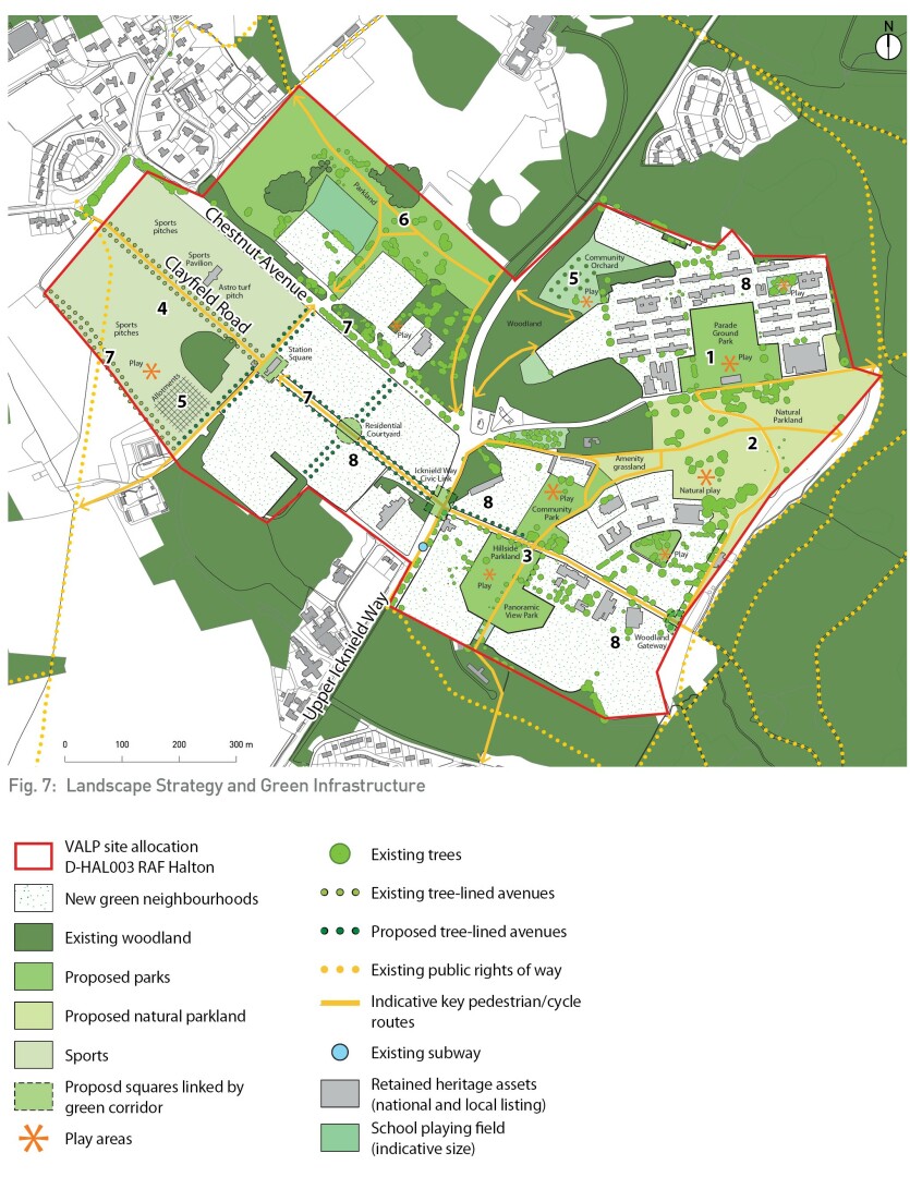
Fig. 7: Landscape Strategy and Green Infrastructure
The existing grassland located between Groves and Henderson Barracks to the north and Maitland Barracks to the south is a Local Wildlife Site and this status should be retained through the development of the site, with the expansion of the extent of the biodiversity rich grass and flower sward. The grassland will become an informal public green space with a natural parkland character, separating new residential neighbourhoods. A natural play feature for young and older children could be established on parts of this area to complement the adjoining meadow whilst allowing natural play but should not reduce the biodiversity value of the grassland. The grassland is adjacent to Wendover Woods and also acts as green buffer to the woodland. The need to provide for SuDS should be investigated as part of planning applications.
East-west and north-south pedestrian links with the surrounding landscape will be created. Existing open views across the grassland and towards Wendover Woods are to be retained and viewpoints created. A number of outlying buildings are to be removed to expand and connect the grassland with adjacent green corridors.
A continuous north-south corridor of parkland will run across the south eastern part of the site connecting with existing woods to the south and the natural parkland to the north. The design of the new parkland corridor should respond to level changes and take advantage of the available long distance views across the Vale of Aylesbury. The corridor is to be fronted by development and crossed by the tree-lined avenue which runs east-west across the site.
A range of different parkland spaces are proposed within this green corridor:
- Community Park. A green open space adjacent to the retained former stables and cinema buildings, including a children's play area, kick-about space, and opportunity for other active leisure facilities such as outdoor table tennis and gym, with seating, areas for picnicking and social interaction.
- Hillside Parkland. Design of this open space should respond to sloping topography. Using the natural form of the landscape setting to create viewpoints, natural play areas and terraces.
- Panoramic View Park. Existing views providing visual connection to the wider landscape towards Aylesbury should be maintained and incorporated into the landscape design of this park. New trees should be positioned to create 'windows' to frame the views. Eating, terraces, children's play space and walking trails connecting with woodland to the south should be incorporated.
The existing sports field complex will be retained and become part of a sports and leisure corridor, comprising active leisure facilities and parkland. This will contribute to the general well-being of the existing and future residents by providing sport and recreation facilities to the wider community.
The green corridor should be designed as a linking feature between the new and old and will positively connect Halton village and the new development.
The Nuffield Pavilion and its car park will be retained and used as a sports/community hall for the wider community. Existing sports facilities including the AstroTurf hockey pitch to the south of the pavilion, the grass pitches to the north (immediately west of Chestnut Avenue) and the grass pitches to the west of the tree lined path will be retained.
In addition, there will be provision of a larger children's play space and community allotments to the south west of this green corridor.
To the north of Chestnut Avenue, the sports and leisure corridor continues with informal sports use, overlapping with the Registered Park and Garden (feature 6).
Allotments in the western part of the site within the sports and leisure corridor are identified. A community orchard is identified for the land to the west of the Groves and Henderson barracks area.
The location and size of allotments and orchard are to be agreed with BCC at planning application stage.
Further opportunities for community food growing and fruit trees should be considered across the site.
Within the site allocation area, the Registered Park and Garden (RPG) is to become publicly accessible green space with an estate parkland character including groups of trees and woodland in keeping with its historic role as part of the Halton House estate. Opportunities to open up views to Halton House should be explored in the detailed landscape design and the arrangement of adjacent buildings. A footpath and cycle route is to be provided running between Upper Icknield and Halton Village.
In line with recommendations by Historic England, the existing built blocks which currently project into the RPG are to be removed enabling the enhancement of the RPG. Development of the local centre and school adjacent to the RPG should be sensitively designed to create a positive edge to the landscape and be mindful of views from Halton House looking down towards the development.
Existing tree lined avenues along Chestnut Avenue, Clayfield Road and by the south-western boundary of the site should be retained and incorporated into the overall design.
There is an opportunity to create a green east-west avenue connecting Halton village to Wendover Woods across development site, through the extension of Clayfield Road to the east. The western part of the east-west avenue will provide vehicle access to the new residential neighbourhoods along Chestnut Avenue; whilst the eastern section from Upper Icknield Way, will provide bus and vehicular access to that part of the site. The design on the east-west avenue will need to balance the need for vehicular access with the route's main focus as a high quality walking and cycling route, linking a chain of public parks and public squares: Station Square, Residential Courtyard, Icknield Way Civic Link, Hillside Parkland and Woodland Gateway.
New neighbourhoods are to have high quality incidental amenity spaces, pocket parks and public realm. These spaces should provide recreational features for users of all ages and include high- quality public art, hard and soft landscape, seating, children's play, habitat areas, and community food growing.
Homes should have planted private amenity space in the form or rear gardens and/or front gardens, balconies, roof gardens or communal garden space. This should be provided in line with
Principle DES43 in the Aylesbury Vale Area Design SPD, adopted 2023.
Streets should be planted with street trees wherever possible to provide attractive leafy character and green links throughout the site.
Equipped play space provision should be in line with Fields in Trust publication 'Guidance for Outdoor Sports and Play Beyond the Six Acre standard' or subsequent guidance; and VALP Policy BE2 and Appendices C&D as well as the detailed guidance in Principle DES34 in the Aylesbury Vale Area Design SPD, adopted 2023.
For 1000 homes and assumed 2500 population this equates to 0.625 ha of equipped/designated play areas and 0.8 ha of other outdoor provision such as MUGAs and skateparks. Within the site, the provision should be provided primarily as LEAP, NEAP and MUGA facilities in the indicative locations shown on Figure 7, with smaller LAP facilities provided within the identified residential areas. Play space should be designed to be universally accessible and located away from major roads.
Features which support natural play / playable spaces should incorporated into all other landscape areas.
A circular leisure, walking and cycling route is proposed to provide a longer distance leisure route through the site's attractive landscape assets. The route would not be a designed or segregated route but would follow existing routes within the site.
3.4 Heritage
The development of the site will need to take into consideration the existing heritage assets on site and within close proximity. In accordance with VALP Policy BE1 and advice from Historic England, a full Heritage Impact Assessment, to include archaeology, should be prepared by the DIO as soon as possible to inform planning applications.
The location of the heritage assets can be seen on Figure 8. These assets are:
- Grade II listed buildings of Groves and Henderson Barracks
- Grade II* listed Halton House
- Grade II listed Registered Park and Garden associated with Halton House, which is also identified on the Heritage at Risk Register
- Scheduled Monument, remains of a long barrow in the north east of the site
- Archaeological notification area, generally aligning with the Registered Park and Garden, and covering land to the south west of the site
- Conservation Areas at Halton village and Wendover
- Non-Designated Heritage Assets across the site
Figure 8 shows the Heritage Strategy for the site.
Designated Heritage Assets
All nationally listed building and structures within the site boundary are to be retained and enhanced whilst ensuring viable uses are consistent with their conservation. The retention and/or provision of an appropriate setting for those listed structures from the redevelopment of the rest of the site should be ensured.
Following a listing assessment by Historic England, Building 27 within the Groves and Henderson Barracks was officially listed in July, 2023.
Locally listed assets (Non-designated heritage assets)
A number of existing buildings on site have been nominated as important in identifying local character and are going through process of being included on the local heritage list as Non- Designated Heritage Assets (NDHA). The overall significance of Building no.98a, a former gas decontamination building is currently classed as low; its status is currently unknown. Historic England has asked the DIO to investigate whether the building contains any original features, which, if present, could increase the building's significance.
All NDHAs within the allocation boundary are classified as being suitable for retention except the Old Workshops which are to be removed to enable policy and placemaking objectives to be met.
Removal of any other NDHAs will require clear justification at planning application stage; there is a strong presumption in favour of retention as heritage assets are an irreplaceable resource that inform our local history and create the local character and special quality of an area. Any heritage assets to be removed as part of the development of the site will need to be recorded in accordance with Historic England guidance.
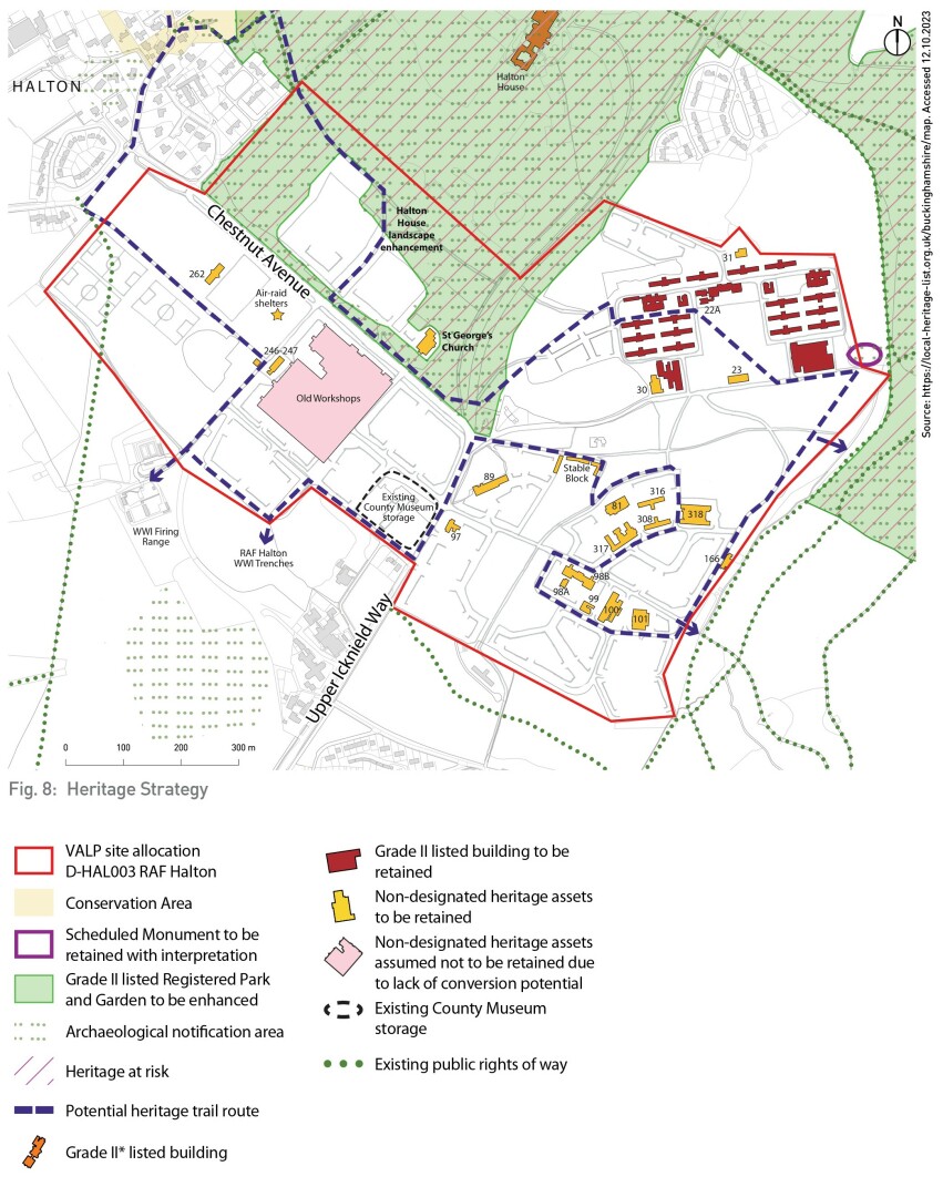
Fig. 8: Heritage Strategy
Halton House and Registered Park and Garden
The Council places importance on repairing the setting of Halton House, including works to enhance the associated Registered Park and Garden within the strategic allocation. Inter-visibility between any development in the north western part of the SPD area and Halton House requires careful consideration in the detailed design, to minimise negative visual impacts arising from development. Historic England recommends that a sensitive be taken to any further development within the allocation in the section of the RPG north-east of Chestnut boundary. Historic England also welcome the Conservation Management Plan for the RPG and its recognition that the Sergeant's Mess building is not in keeping with the historic setting of Halton House.
The Registered Park and Garden (RPG) extends into the allocated area and has an important future role as part of the publicly accessible landscape setting of the proposed development. The RPG is currently on the Heritage at Risk Register and the redevelopment of the site offers an opportunity to conserve and enhance it, including through the removal of outlying built elements towards the site's north western boundary. This will increase the sense of openness and provide a positive relationship between the built form and landscape. Historic England advises updating the Conservation Management Plan for the Registered Park and Garden, including further details of the opportunities for enhancement.
Scheduled Monument
There is an opportunity to enhance the setting of the Scheduled Monument that sits at the edge of the SPD site boundary at the foot of Wendover Woods. Any development that have a potential impact on the setting of the monument will need approval by Historic England.
The council's preference is for the modern, rear extension of Building 28 to be demolished to create an area of open space adjacent to the monument, improving its setting. Historic England note that demolishing the extension and replacing it with new housing will, at best, have a neutral effect on the setting of the Scheduled Monument, but that they are hoping for an enhancement of its setting through the redevelopment of the strategic allocation.
Archaeological findings during any demolition and development works in proximity of the monument are to be monitored by the Council. Any works which impact on the monument or its setting will require discussion directly with Historic England and may require Scheduled Monument Consent.
Heritage Interpretation
There is an aspiration to interpret the site's history and cultural in a museum, , on Upper Icknield Way, which has the potential to combine the County Museum Resource Centre and Trenchard collections. This would be publicly accessible and could enable improved management and access to the nearby World War I training trenches which are located to the south west of the site boundary.
A Heritage Trail is proposed across the wider site which connects the nationally listed buildings and parade ground, locally listed buildings, proposed heritage hub, Registered Park and Garden and Halton village. It connects with paths into Wendover Woods and Halton Conservation area.
Information boards or interactive interpretation material and signage is to be provided exploring the history of the site. An introduction to the site and its history for new residents or users could be produced. The trail should reflect the assets that will remain in perpetuity, the results of archaeological investigations on the site and also reference those buildings and assets that may have been removed.
Heritage Character
Redevelopment of the site should reflect and maintain other elements of RAF and Rothschild heritage character. These include:
- Aspects of the urban form such as the arrangement and formality of barracks blocks
- Use of locally appropriate materials
- Architectural forms and details drawing on the Rothschild and RAF architecture
- Retaining key streets and avenues
- Retaining public realm details such as the original black and white striped kerbs
- Street names which reflect the heritage of the site.
3.5 Movement and Access
The VALP establishes a sustainable transport vision with a people-orientated transport hierarchy that promotes modes of travel which minimise environmental impact and promote social inclusion. In responding to this vision, the design of Halton Woods is to prioritise walking and cycling, deliver upgrades to bus services and enable residents to reduce their reliance on private cars.
Walking and Cycling
An internal network of walking and cycling routes is proposed to enable residents to easily access proposed facilities within the site, and connect with the wider street and public rights of way network local destinations. The provision of new connections to LTN1-20 should be considered.
The following elements are proposed as part of the connected network of on-street and off-street routes:
- New walking and cycling routes located within green corridors and along the east -west avenue providing walking and cycling connection across the site.
- DDA compliant, alternative low gradient routes that will provide easy walking and cycling routes around the neighbourhood taking into consideration the topography of the site and the accessibility issues that this may bring.
- Safe crossings points on Upper Icknield Way and Chestnut Avenue and at the junction of these two streets including greater use of the existing subway through an appropriate development layout.
- Connections to existing and planned strategic walking and cycling network including links to:
- Wendover Station and town centre
- Halton village
- Wendover Woods
- Grand Union Canal towpath, Greenway, Amber Way, Marrow Way and Gardenway
- Improved walking and cycling facilities along the B4009. This could include the opportunity for an e-bike hire scheme.
Indicative key pedestrian and cycle routes are identified on Figure 9.
Vehicle Access and Street Network
Vehicular access to the site will be taken from the two existing primary roads, Upper Icknield Way and Chestnut Avenue, utilising existing access points wherever possible. Dacre Road is to become bus only, removing the vehicle access between Groves and Henderson Barracks and the Upper Slopes.
Opportunity should be taken to reuse existing internal streets where appropriate. The design of streets within the development should accordance with Manual for Streets and Manual for Streets
2. All internal secondary and tertiary streets across the site will be 20mph speed limit and designed as 'places' rather than highways, framed by development and creating comfortable environments in which to walk and cycle.
All streets will be designed to be DDA compliant where possible, with low gradient routes, inclusive and welcoming to all ages and abilities.
Existing large black and white kerbs should be retained to reflect the site's military heritage.
Upper Icknield Way (B4009)
Upper Icknield Way will continue to be a through route for vehicles but the character of the route will change to become a street rather than a highway, with a focus on creating an attractive and safe environment for pedestrians and cyclists.
Pedestrian and cycle priority should be provided by introducing traffic calming measures and introducing new formal pedestrian and cycle crossing points. This will deliver improved connectivity between east and west sides of the development.
Chestnut Avenue
Traffic calming measures and public realm enhancements should be integrated along Chestnut Avenue to enable easy access to the proposed local centre and school, and reduce traffic speeds to 20mph. The street is to be configured to enable bus use with a bus stop in the vicinity of the local centre. Consideration should be given to traffic management measures that discourage through vehicular traffic between Chestnut Avenue and Halton village. and to focus instead on opportunities for wheeled and pedestrian travel.
The adjacent Swann Lane could provide an opportunity for a some pedestrian or cycle provision running parallel to Chestnut Avenue.
Upper Icknield Way/Chestnut Avenue junction
Provision of junction improvements onto the B4009 Upper Icknield Way are required and are to be safety and placemaking-led to enable easy access for pedestrians and cyclists between the different parts of Halton Wood. There is an opportunity to tighten the junction radii, introducing formal crossings and enhance road safety through the reconfiguration of the junction.
The nature of junction upgrade requirements will be agreed following transport modelling as part of a future planning application.
There is an opportunity for public art at the junction marking the gateway to Halton parish.
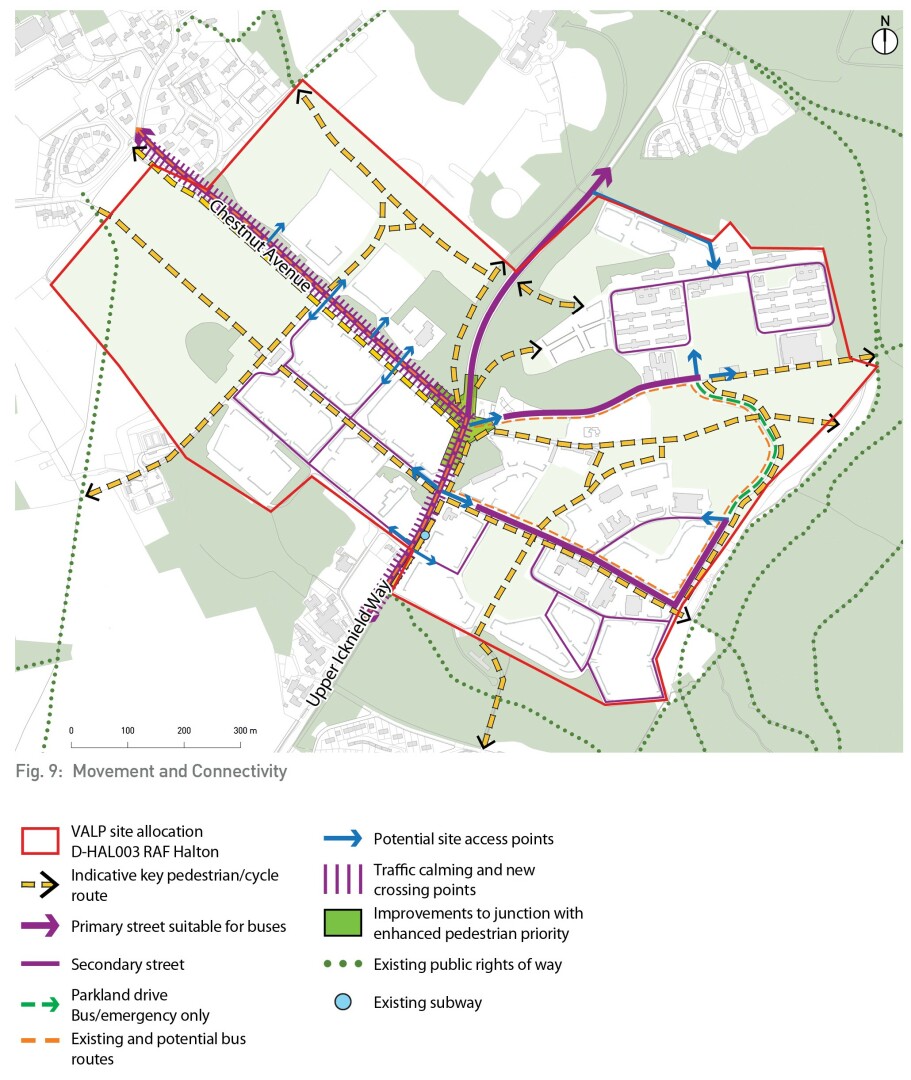
Fig. 9: Movement and Connectivity
Public transport
All dwellings are to be located within 300m of a bus stop, with improvements to bus routes serving Upper Icknield Way and Chestnut Avenue sought, and connecting the site to Wendover and Halton Village.
In order to deliver 300m bus stop access in the eastern part of the site Groves Road, Dacre Road and Maitland Drive are to be designed as an additional bus route. Dacre Road is to be reconfigured as a parkland drive with bus, cycling and walking access only. There is a potential to narrow the existing carriageway, minimise road markings and provide appropriate parkland surfacing.
Indicative existing and proposed bus routes are shown on the Movement and Connectivity Plan (Figure 8).
Parking
Car parking provision across the site will be in line with VALP parking standards, or those in place at the time the development comes forward Due to the nature and existing constraints it may be challenging to meet the local parking standards in some parts of the site, therefore innovative car parking solutions will be encouraged.
Shared parking opportunities should be explored to utilise the relationship and close proximity of the school, local centre and sports facilities. Drop off and pick up arrangements for the school could utilise the existing service road that is located in front of the Kermode Hall. In line with Department for Education Guidance for School Design and design policies in the VALP, parking should be discreet and not dominate the building frontage.
Off-site connections and off-site highways works
There will be a need to provide general traffic calming strategy around Halton to avoid rat running via Weston Turville and encourage development traffic to route via A41 and A413. This includes consideration of the constrained Perch Bridge to the south of Halton Village. This, and other potential offsite infrastructure enhancements are to be informed by wider traffic modelling, the scope of which is to be agreed with Buckinghamshire Council highways.
The development should consider the wider Local Plan proposals, as well as committed development future traffic scenarios using Buckinghamshire Council's updated Aylesbury strategic Transport Model. In order to input into the Strategic Model the following details will need to be agreed in principle:
- Existing trip generation
- Zoning of development
- Access arrangements
- Trip Rates for all uses
All future planning applications will be assessed by Active Travel England according to these standards.
Transport assessment and modelling will be required for future planning applications:
- to consider wider impacts on network and villages
- need for off-site junction improvements
- support creation of walking/cycling link
3.6 Urban design and place making
The high-quality setting and heritage of Halton Woods requires an exceptional design response. Bespoke, sustainable architecture and landscape architecture is required to deliver beautiful places to live which also support Buckinghamshire's commitment to addressing climate change. A standard, suburban design approach will not be acceptable.
The development will create areas of different character which respond to variations in the existing character of the site, the site's setting and views in and out of the site. This variation is explored further in section xxx. However, the design of Halton Woods will seek to create a cohesive place, which is connected and legible, and has a distinctive character as a whole.
Views
Key views and vistas are identified on Figure xx, and should be reflected in the alignment of streets, buildings and tree planting. The layout should be designed to retain and open up new views to Wendover Woods from the centre of the site; towards Aylesbury Vale from the eastern, raised areas of the site; across and into the Registered Park and Garden from Chestnut Avenue and the sports and leisure corridor, and where possible, create views towards Halton House.
Views towards local landmarks including St George's Church, the former stables and cinema buildings, and towards distinctive new buildings, should be created to enhance the legibility of the site, and visually connect the different parts of the site.
Key frontages
New buildings should have doors and windows fronting the public street network, public green spaces and footpaths and cycleways, and avoiding blank facades in these locations in order to provide passive surveillance of these spaces, with private garden space to the rear.
In relation to retained heritage assets, attention should be paid to the location of existing entrances and building frontages and the definition of public and private open spaces, in order to incorporate retained buildings appropriately within an overall block structure of new and old.
Key frontages are identified on Figure xx, emphasizing the importance of creating an appropriate sense of enclosure to primary streets and open spaces. Development should front towards Chestnut Avenue to the north and south, set back behind retained high quality trees, with lower level vegetation and low-quality trees cleared to enable increased visibility and access north-south (subject to ecological and arboricultural assessment). Similarly, development to the east and west of Upper Icknield Way should front onto the street, with a complementary scale and design on either side to create a cohesive street character.
Building heights
The overall heights of new buildings should work in harmony with existing buildings, and respond the sensitivities of the surrounding landscape and heritage context. New residential buildings will range from 1-3 storeys in height, averaging 2 storeys, reflecting the scale of existing buildings within and surrounding the site. The SPD seeks to limit taller buildings which would have a negative impact on the Registered Park and Garden and Halton House. To that end, development to the north of Chestnut Avenue should step down to a maximum of 2 storeys towards the site boundary. Development immediately adjacent to Wendover Woods should also be a maximum of 2 storeys.
There is scope for a limited number of buildings of up to 3.5 storeys in the lower lying areas of the site to the south west of Chestnut Avenue, where these help to establish a particular character area and emphasise key public locations. Such building heights may also be appropriate to emphasize key corners or gateway locations in other areas of the site but will only be permitted where exceptional design can be demonstrated, including in relation to the setting of heritage assets. In important gateway or corner locations a particularly high quality and well considered design response is required given their visibility.
Treatment at the edges of the site
There is a need for considerations of the edge of the, site and how development relates to the surroundings. This is specifically important in those areas of transition which include:
- How the site relates to the steeper slopes on the edge of the Maitland Barracks in the Upper Slopes character areas;
- How the site relates to Halton House and the Registered Park and Gardens
- How the site relates to the existing village of RAF Halton
- How built development transitions to adjacent woodlands and other semi-natural habitats.
Housing mix
A variety of different housing tenures and sizes (from 1 bed to 4+ bed) should be provided to meet local market and affordable housing needs, set out in Buckinghamshire Council's latest evidence and provide accommodation to suit a range of household sizes and ages and create sustainable communities.
Accessible and adaptable units will need to be incorporated within the development in line with VALP policy H6c. Affordable housing and Self-Build and Custom-Build plots are to be provided in line with existing and emerging Development Plan policies.
Housing typologies and density
Proposed appropriate densities and building heights across the site are illustrated on Figure 10 and guiding principles that should be considered are provided below. In general, there is to be an emphasis on formally arranged, terrace and townhouse typologies with bespoke architectural design, to create a strong sense of enclosure to streets and spaces and avoid a low density, suburban character.
Residential character
Net density
Formal street layout, terraces, town houses and apartments. 2-3.5 storeys
Density approx. 40-50 dph
Terraces, town houses and semi-detached family houses. 2-3 storeys
Density approx. 30-40 dph
Short runs of terraces, semi-detached and a smaller proportion of detached houses. 2 storeys.
Density approx. 25-30 dph
Retained buildings to be converted to residential use
n/a
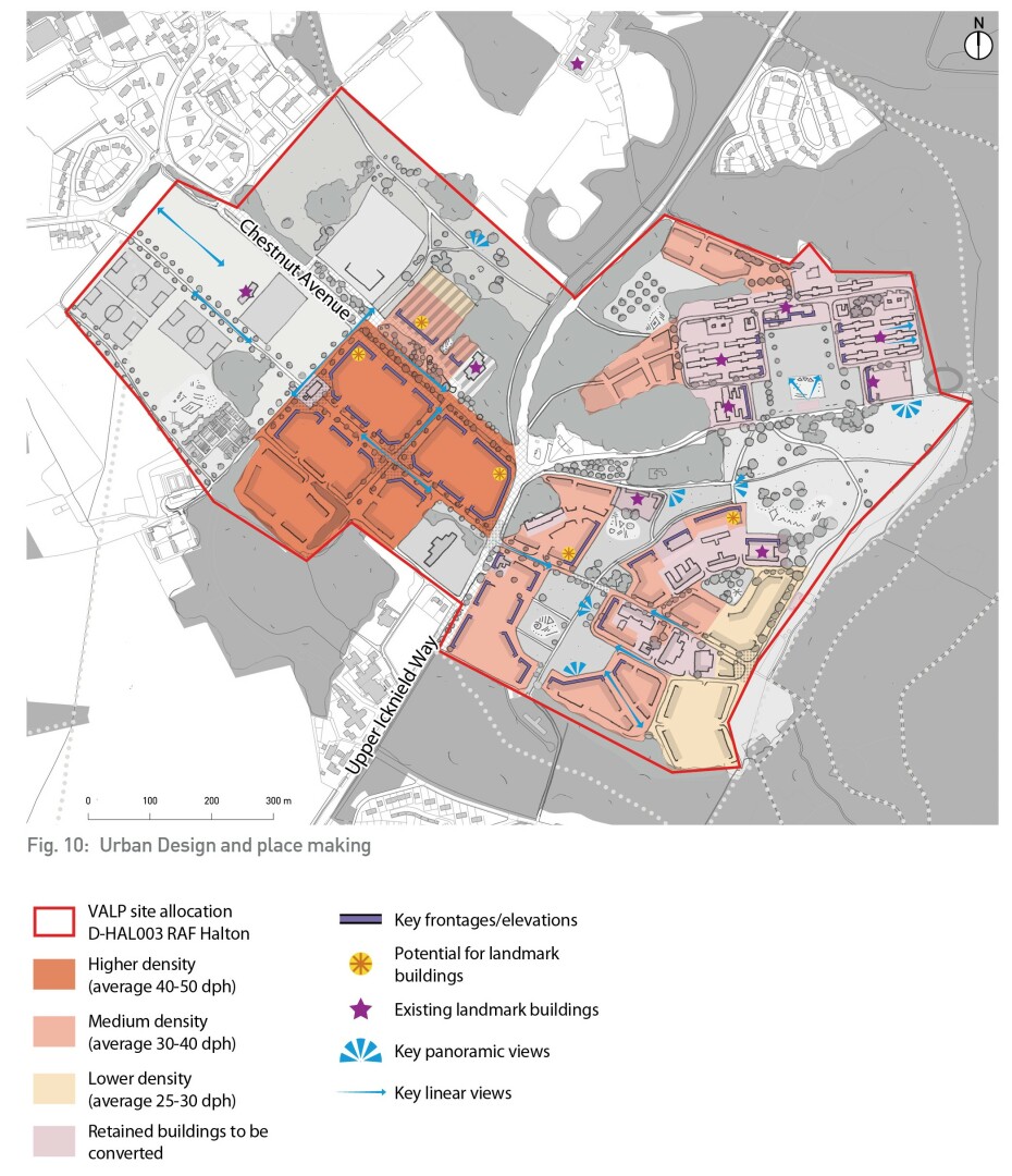
Fig. 10: Urban Design and place making
3.7 Character areas
Four character areas for built development are proposed to create legible and distinctive neighbourhoods in different parts of the site:
- Upper Icknield Way
- Chestnut Avenue
- Groves and Henderson Barracks
- Upper Slopes
Variation in character across the site will reflect differences in the existing landscape and views, heritage and built form, proposed density and land use, function, busyness and accessibility.
Figure 11 identifies the general locations of these proposed character areas.
Each character area has a strong relationship to the landscape which surrounds it and proposed landscape features within the site. Further information on the proposed landscape features/character is provided in section 3.3.
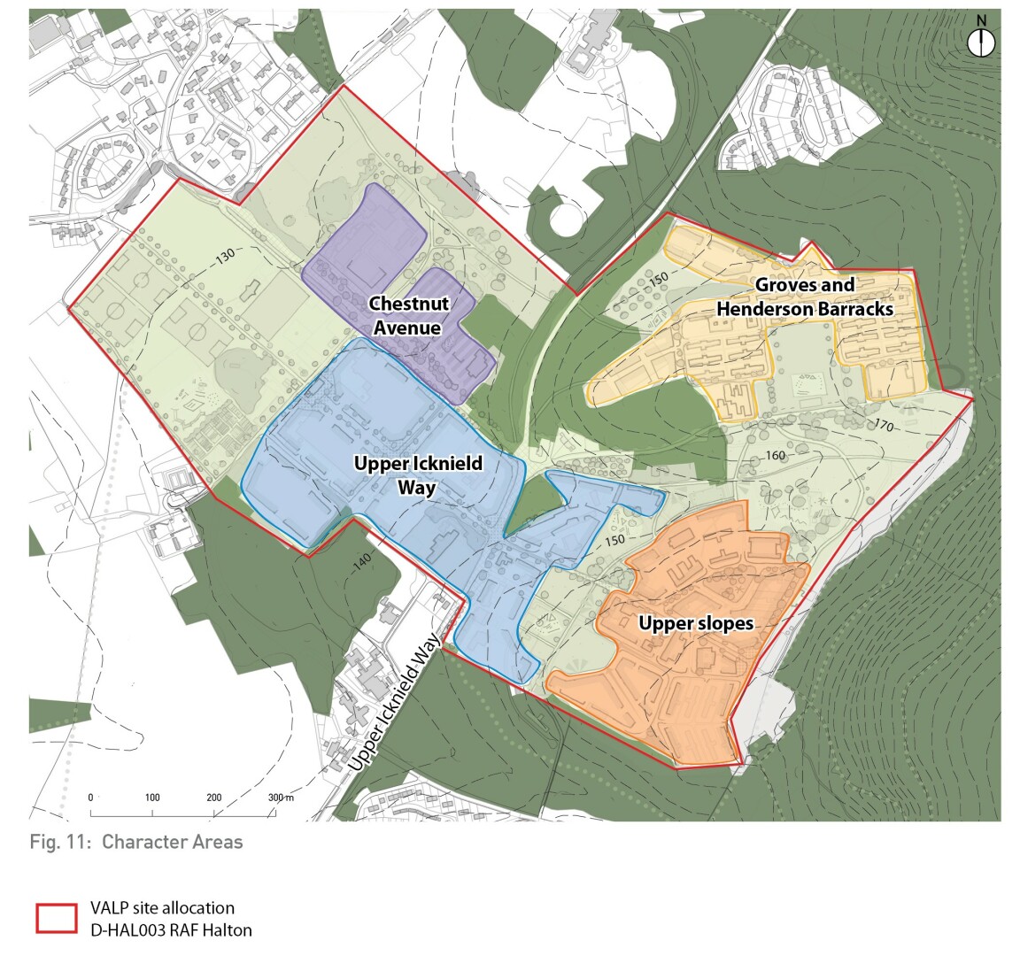
Fig. 11: Character Areas
Character Area: Groves and Henderson Barracks
This character area covers the listed barracks and adjacent land to the north and west of them that is identified for new build residential development. This area feels relatively separate from the rest of the site, enclosed by the slopes of Wendover Woods to the east and woodland to the north, west and east. From the southern part of the character area, there are panoramic views across the Upper Slopes character area.
The historic interest of this area relies on its military character as a whole rather than individual structures. As a result, the Council and Historic England welcome proposals which retain and reuse all listed buildings in viable, long term uses, while retaining the campus-like feel of the barracks. This will require an innovative and carefully considered design response. The Parade Ground is to become a new public park at the centre of this character area.
Design guidance:
- Retain and reuse all listed buildings with viable, long term uses. It is assumed that the buildings will be converted to residential uses however on those buildings that are difficult to convert the Council would consider alternative long-term uses subject to an assessment of the heritage impact of the proposal. Historic England are open to accepting a more flexible approach to the conversion of the listed Groves and Henderson Barracks, in recognition of the viability challenges that these building present. One of the Barracks blocks should be retained as an exemplar, with minimal adaptations, including the retention of the external staircases to give insight into the building's original character and use.
- Maintain key aspects of the public realm and outward appearance of the barracks such as the open lawns and some of the barrack staircases where they provide unaltered examples of the original design. This will limit the potential for private amenity/garden space and as a result, high quality community amenity spaces are to be provided across the character area and in the Parade Ground Park.
- Careful thought will be needed as to how parking is to be arranged and managed to avoid harm to the setting of the barracks. It is expected that parking with appropriate landscaping will be dispersed in less sensitive locations at the edges of the site, with some limited parking accommodated within the Parade Ground Park. Innovative solutions such as car barns outside the barracks area could be considered. Any parking solutions will need to be mindful of the impact on the Scheduled Ancient Monument.
- Historic England is in favour of preserving the ground floor of one barrack in its current form as a representative of what the interiors were like historically.
- The design of new residential properties to the north and west is to be complementary to the adjacent listed barracks in its architectural style, materials and scale. Contemporary design is welcomed. There is an opportunity to provide larger houses in these locations, to balance the housing mix in this character area.
- The design of the Parade Ground Park is to retain its formal character, key views out to the east/west and south and sense of openness. See Landscape Strategy section 3.3 for further guidance.
- Vehicle access to the area will be via the existing Groves Road to the south and Polish Avenue to the north. Additional walking and cycling routes will be provided to the south and west to connect the character area with the local centre and Upper Slopes character area.
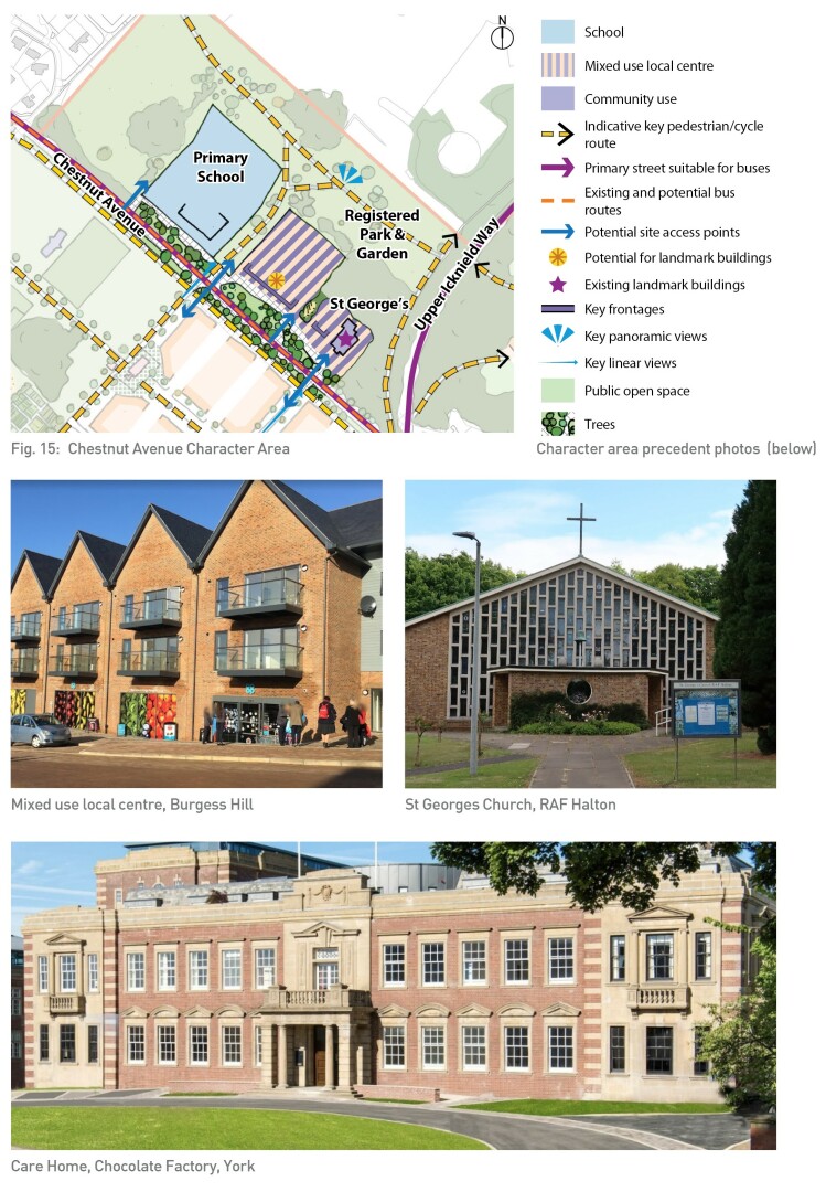
Fig. 15: Groves and Henderson Barracks Character Area
Upper Slopes
The Upper Slopes character area covers the former Maitland Barracks which is located on the higher land at the foot of Wendover Woods. It is to become a new residential neighbourhood, benefitting from long, panoramic views to the west across the Vale of Aylesbury. A number of non-designated heritage assets are to be retained as part of the development.
Design guidance:
- Streets and buildings should be arranged to frame long distance views west and views east to the wooded hillside.
- High quality development frontage, with a near continuous character should be provided to frame and overlook the proposed north south parkland corridor, and the smaller internal park.
- Building heights should respond to the sensitivities of the adjacent landscapes and impact on views into the site, stepping down from 3 to 2 storeys in the east adjacent to Wendover Woods.
- High quality, contemporary design that is complementary to the retained heritage assets will be welcomed. Where possible, new development should maintain the street layout/ angled streets that contribute to the existing character of the area.
- Maitland Road crosses the character area and provides the primary vehicle access. As part of the proposed east-west tree-lined avenue it will incorporate high quality walking and cycling routes connecting into Wendover Woods at the eastern end of the site, where a small public square is to be created.
- The character area overlooks the proposed north-south green corridor, details of which are provided in section 3.3.
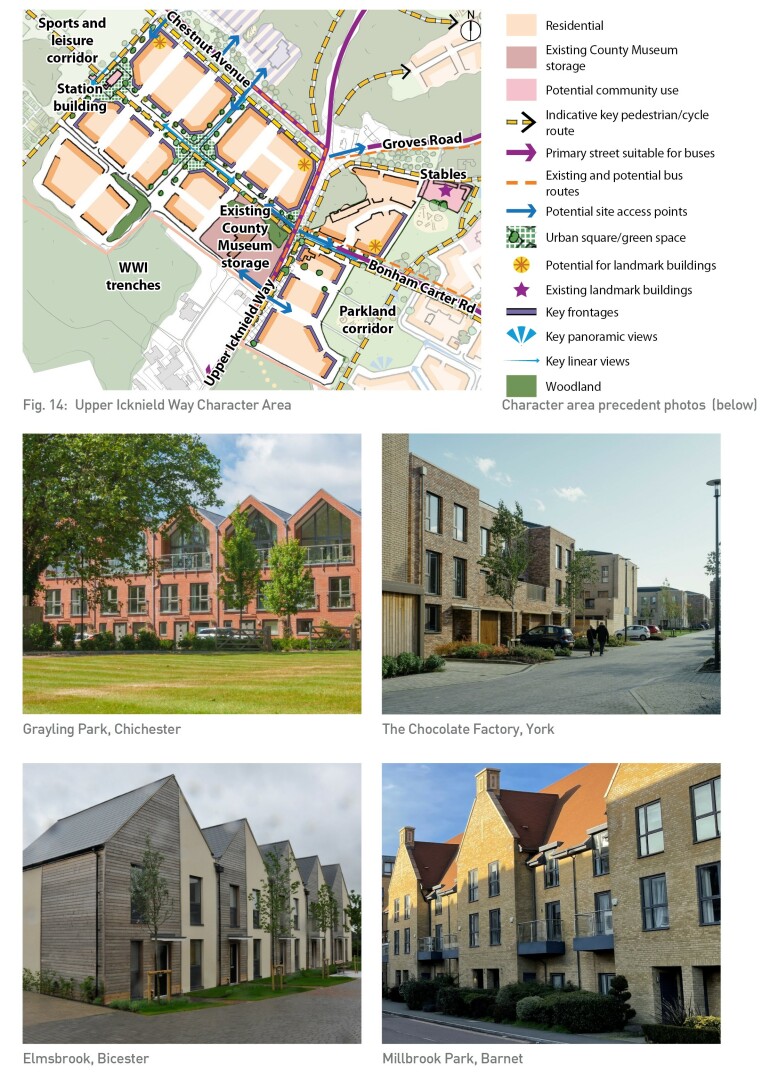
Fig. 14: Upper Slopes Character Area
Upper Icknield Way
Upper Icknield Way acts as the gateway entrance to Halton Woods. It is located on the flatter, low lying part of the site to the west of Upper Icknield Way which is suitable for a higher density, more intensive form of development. The character area also includes land to the east of Upper Icknield Way to enable a joined-up approach to development character on either side of the primary street.
Design guidance:
- The existing workshops (non-designated heritage assets) are to be removed due to their very large size and current condition making them not viable for conversion and potentially impacting the deliverability of 1000+ dwellings in accordance with VALP Policy HAL 003. As a result of the removal of the workshops, a better street network is also able to be created, including the proposed east-west tree lined avenue.
- The area is to deliver a range of different housing typologies with an emphasis on terrace, townhouses and apartments of between 2-3.5 storeys in height to the west and 2-3 storeys to the west of Upper Icknield Way.
- A contemporary architectural character is encouraged. Buildings are to be formally arranged within the street, with architecture reflecting aspects of the former warehouse character where appropriate, for example in the roofscape.
- The alignment of streets should create views towards St George's Church, the local centre and landscapes to the west and north west.
- The east-west tree-lined avenue is to create a link between the sports and leisure hub to the west and Upper Icknield Way, linking a series of small urban squares/green spaces, one of which is to incorporate the former station building.
- Active frontage should be provided towards Upper Icknield Way and Chestnut Avenue wherever possible, to support a transformation in character from highway to pedestrian- friendly street.
- Existing RAF community uses to the east of Upper Icknield Way including the children's nursery and community centre should be considered for retention or reuse as 'meanwhile' community facilities to serve the early phases of the development.
- Vehicle Access to the character area will be via the existing junction onto Chestnut Avenue, a further new junction to the east onto Chestnut Avenue and via Rowborough Road onto Upper Icknield Way.
- Swann Road will provide a parallel route to Chestnut Avenue for cycling and walking, with limited vehicle use for access only.
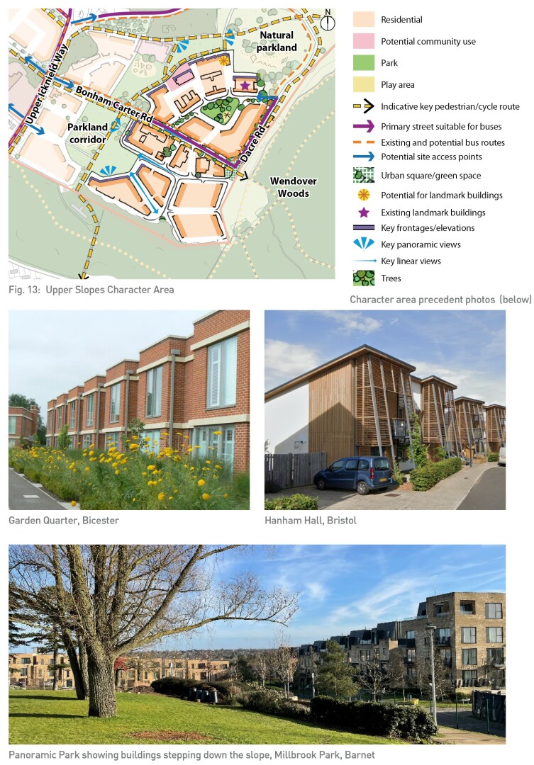
Fig. 13: Upper Icknield Way Character Area
Chestnut Avenue
Land to the north of Chestnut Avenue is the location of the proposed local centre and school. Development in this character area needs to respond positively to the landscape character of the Halton House Registered Park and Garden, and look to enhance the setting of the House. This will entail careful consideration of the distribution and design of buildings, especially in that north east section and along Chestnut Avenue, and potentially the provision of an adequate and appropriate planted buffer.
Chestnut Avenue itself has a strong existing character, lined by mature trees and with long distance views towards Wendover Woods. This character is to be enhanced while enabling enhanced visual and physical connectivity between the land to the north and south of the Avenue.
Design guidance:
- The built footprint and height of the local centre and primary school are to respond to proximity of grade II* listed Halton House and Grade II Registered Park and Garden, probably reducing in scale and density to the northern boundary of the site.
- The development footprint is to be reduced and consolidated to re-establish parts of the estate landscape. This includes locating the buildings associated with the primary school on land adjacent to the RPG.
- To further minimise visual impact, detailed design should consider the potential for green roofs and integration of other landscape elements to reduce the visual impact of development when viewed from Halton House.
- The proposed development should make positive contributions to character and visual amenity within the public realm and to views from the RPG, including (but not limited to) attractive built frontages and streetscapes, dynamic roofscapes, integrated tree planting and open spaces. Development should ensure key views from the RPG are retained and enhanced where possible by the removal of existing buildings and careful placement of new buildings to ensure views are unobstructed, opened up where appropriate, and buildings serve as accents or framing elements to the views.
- The character of built development is to respond to the architectural style, materials and detailing of the Rothschild Estate at Halton.
- The potential to retain some or of all of the existing buildings including the Kermode Hall should be explored.
- Other features of heritage interest including the Apprentice's Tribute sculpture and the pill boxes across the site should be retained and incorporated into the design of the public realm.
- The local centre is to front principally towards Chestnut Avenue, set back behind mature trees, and with a shared surface space to the front providing a small number of visitor parking spaces, spill out space for cafes/businesses and a high quality public realm.
- Hard and soft landscaping should be provided to help provide legibility along Chestnut Avenue and a clear centre for the development.
- The mix of uses envisaged for the local centre are detailed in section 3.2.
- The upper floors of the local centre and land to the rear (north) are appropriate for residential use, including the potential for specialist older persons accommodation.
- St George's Church is to be retained and repurposed as a community hall, which forms an integral component of the local centre. The important stained glass is to be protected.
- Vehicle access to the local centre is to be via the existing junctions onto Chestnut Avenue. An additional vehicle access is to be provided to the west onto Chestnut Avenue to enable a dedicated access point, to the school with a second access shared with the local centre to enable in and out access.
- It is envisaged that servicing of the local centre units will be via the front, and should be managed to minimise impact on the quality of the public realm.
- Walking and cycling links to the local centre will be provided by new formal crossing points across Chestnut Avenue and through the creation of a route through the landscape to the north connecting to Upper Icknield Way.
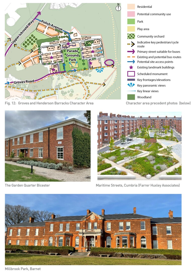
Fig. 12: Chestnut Avenue Character Area


