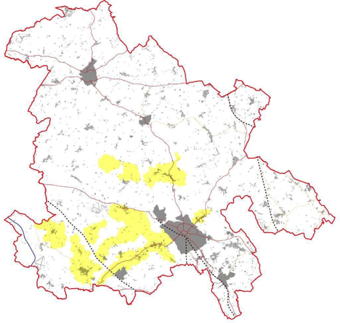
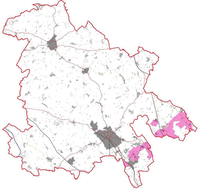
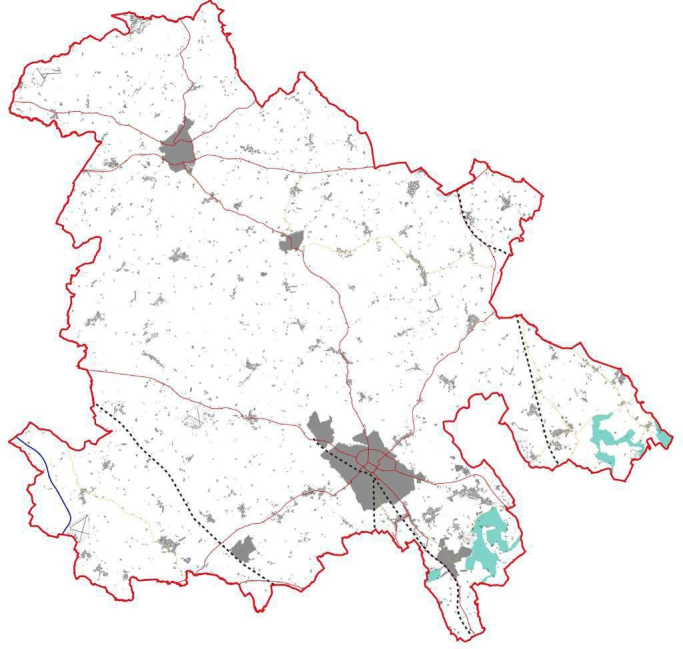
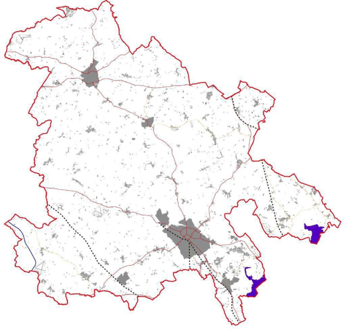
Aylesbury Vale Area Design Supplementary Planning Document
B Landscape character typologies
|
Typology |
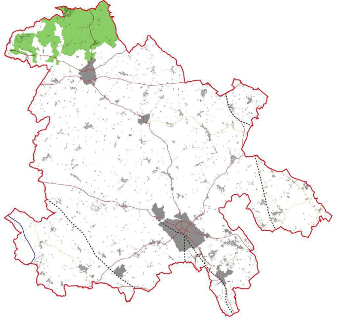
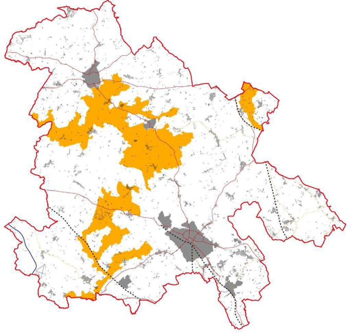
LCT01: Wooded Ridge |
|
Land form and views |
A broad and gently undulating ridge which lacks dramatic landform, however incised valleys mark the plateau margins. Views are generally contained by woodland. |
|
Vegetation |
Coniferous and broad-leaved woodland give dense land coverage. Ancient woodland blocks and a strong hedgerow pattern with mature oak trees sit alongside this. |
|
Settlement and materials |
The dispersed settlement pattern and meandering lanes add to the tranquil character. Local vernacular and traditional building materials of limestone, timber and predominantly red brick. |
|
Settlements within area |
Towns: Buckingham (northern edge). Medium and small villages: Akeley, Maids Moreton, and Stowe and Dadford. |
|
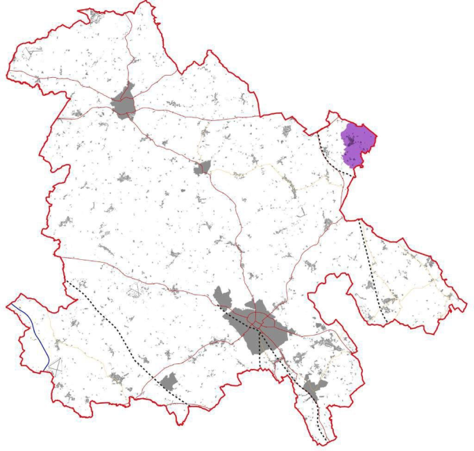
Typology |
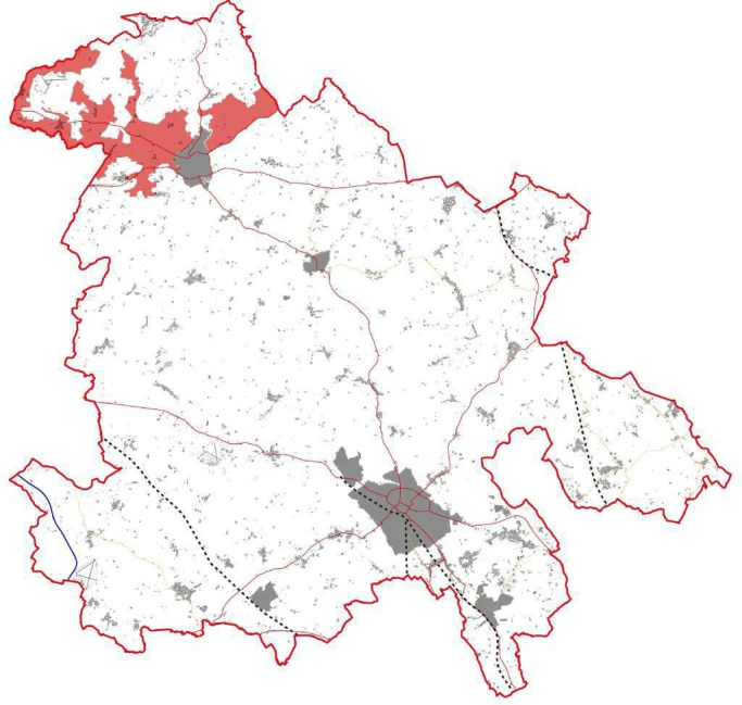
LCT02: Incised Valleys |
|
Land form and views |
Small, steep and narrow valleys created from the incision of the Great Ouse. Landform limits views and visual detractors arise from main roads and arable farming. |
|
Vegetation |
Ecological interest is created from the base-rich ferruginous fens and scattered woodland. Oak and some ash dominate alongside ground flora typical to ancient woodland. |
|
Settlement and materials |
Historic settlement in traditional materials of limestone, timber and red brick, and field pattern, including isolated farmsteads, is focused along the Great Ouse river before dispersing up-slope as arable farming becomes the dominant land use. |
|
Settlements within area |
Towns: Buckingham (western and eastern edges) Medium and small villages: Chackmore, Turweston and Westbury. |
|
Typology |
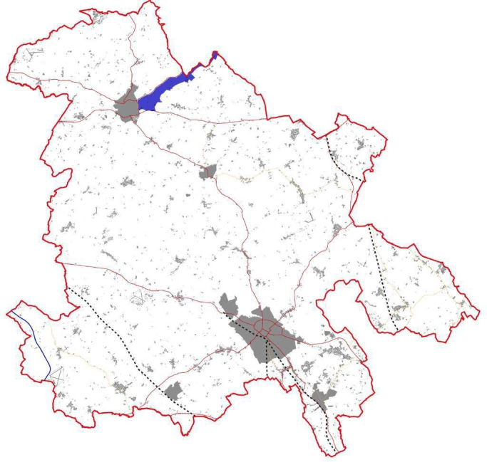
LCT03: Valley Bottom |
|
Land form and views |
The wide floodplain straddling the Great Ouse is coupled with gently sloping topography. Views are generally constrained by landform, and pylons and roads act as visual detractors. |
|
Vegetation |
Great biological interest is found within bankside vegetation, wetland trees, shrubs, grasses, reeds and small woodland pockets. Distinctive willows overhang the meandering river. |
|
Settlement and materials |
Intimate and enclosed landscapes exist along the river, turning to large-scale arable farming further up the valley sides. The low density of typically red brick and timber settlement includes traditional weirs and mills. |
|
Settlements within area |
N/A |
|
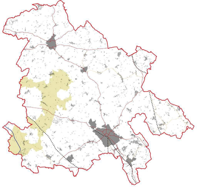
Typology |
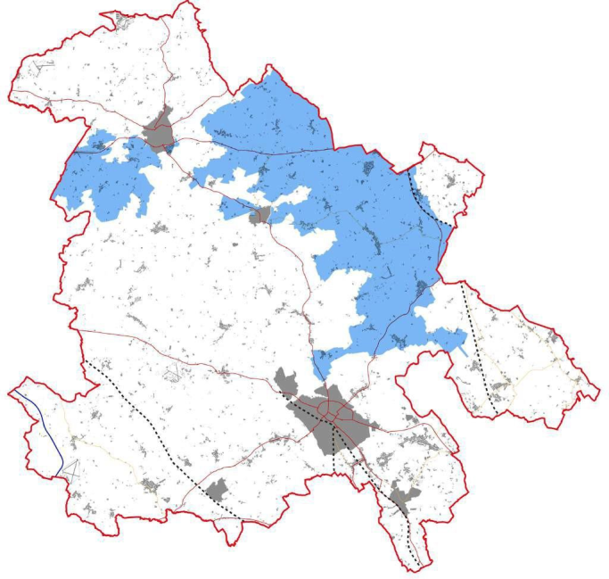
LCT04: Undulating Clay Plateau |
|
Land form and views |
The rolling landform of the clay plateau is shaped by a series of shallow rides and valleys. Views within the LCT are contained by landform; however the plateau margins provide extensive vistas. |
|
Vegetation |
Many fen sites comprise a variety of herb and grass species. Woodland blocks in the north contain a large proportion of ancient woodland and clipped hedges are dominated by oak and ash trees. |
|
Settlement and materials |
Historic villages which are accessed by winding lanes. The landscape structure is enhanced by the vernacular buildings which use a variety of materials including timber, brick and thatch. |
|
Settlements within area |
Towns: Buckingham (south western edge), and Winslow (east and west). Large villages:Wing and Wingrave. Medium and small villages: Aston Abbotts, Beachampton, Cublington, Drayton Parslow, Gawcott, Great Horwood, Little Horwood, Mursley, Nash, Newton Longville, Preston Bissett, Soulbury, Stewkley, Stoke Hammond, Swanbourne, Thornborough, Tingewick, Weedon and Whaddon. |
|
Typology |
LCT05: Shallow Valleys |
|
Land form and views |
Shallow and poorly defined valleys incise the gently sloping or flat landscape, giving limited views over the LCT. Significant visual detractors come from the network of pylons and the railway. |
|
Vegetation |
Biodiversity interest predominantly comes from the river corridor. Pollarded willows and black poplars are important local tree species. Grassland cover dominates with strong hedgerow pattern. Woodland is sparse. |
|
Settlement and materials |
Overall lack of settlement, however some well-preserved, historic, nucleated villages are limited to marginally higher ground. Buildings often limestone, red brick or rendered. Limited road access is coupled with historic and industrial relics, resulting in a remote and tranquil area. |
|
Settlements within area |
Towns: Buckingham (southern edge), and Winslow (north and south). Large Villages:Steeple Claydon (north). Medium and small villages: Adstock, Granborough, North Marston, Padbury, Quainton, Twyford and Westcott. |
|
Typology |
LCT06: Greens and Ridge |
|
Land form and views |
A distinct wooded scarp which has been eroded into an undulating landform, creating steep valleys and small promontories. Long distance views towards Milton Keynes and extensive views over the Ouzel valley. |
|
Vegetation |
Extensive woodland cover consists of ancient semi-natural woodland, secondary woodland and coniferous plantations. Heathland and acidic grassland habitats can also be found. |
|
Settlement and materials |
Narrow and winding lanes traverse up the scarp face. Building materials are typically red brick, with historic examples using mixed materials; red brick, timber, sandstone and render. Great Brickhill village occupies a section of the scarp, displaying strong local vernacular with thatched roofs, local sandstone in buildings and walls. |
|
Settlements within area |
Medium and small villages: Great Brickhill. |
|
Typology |
LCT 07: Wooded Rolling Lowlands |
|
Land form and views |
An undulating clay landscape populated with small ridges and hills. Views to the Chilterns from the south of the LCT however a well wooded and treed landscape limits views The M40 corridor is a visual detractor. |
|
Vegetation |
The dominant grassland coverage is interspersed with large blocks of ancient woodland. A strong hedgerow pattern with mature oaks, whilst poorly drained soil is often scrub. |
|
Settlement and materials |
Low density, historic settlement and its associated enclosure is focused along ridgelines, creating a tranquil character, enhanced by meandering lanes and low-intensity farming. Building materials are typically red brick, with historic examples using mixed materials; thatched roofs, red brick, timber, sandstone and render. |
|
Settlements within area |
Large Villages: Steeple Claydon (south). Medium and small villages: Calvert Green, Charndon, East Claydon, Grendon Underwood, Oakley and Steeple Claydon (south). |
|
Typology |
LCT08: Vale |
|
Land form and views |
Poorly drained, low-lying and flat landscape with an eroded shallow limestone ridge creating isolated fragments of higher ground. Extensive views available from the fringes of the LCT. |
|
Vegetation |
Intricate network of watercourses, including River Thame, are distinctively lined with mature black poplar trees. Surrounding agricultural grassland with mosaic of wet, species-rich habitats. |
|
Settlement and materials |
Roads radiating from central Aylesbury cross the Vale landscape, creating linear settlement patterns. Areas to the north and east are sparsely populated, therefore retaining a sense of remoteness. Historic materials displayed are mixed, typically red brick, limestone, timber, witchert, limestone and/or render. |
|
Settlements within area |
Towns: Aylesbury and Haddenham (southern edge). Large villages: Aston Clinton (west), Edlesborough, Ivinghoe and Stoke Mandeville. Medium and small villages: Buckland, Ford, Hardwick, Ickford, Ivinghoe Aston, Ludgershall, Marsh Gibbon, Mentmore and Ledburn, Northall, Shabbington, Slapton, Weston Turville and Worminghall. |
|
Typology |
LCT09: Low Hills and Ridges |
|
Land form and views |
Narrow ridges and small, steep hills create a distinctive landscape. Dramatic views are a major feature of the type, over both surrounding lower ground and towards the Chilterns. |
|
Vegetation |
Grassland provides the dominant vegetative cover and largely intact hedgerows are populated with ash. The low density of woodland is interspersed with blocks of ancient woodland. Mature and veteran trees indicate designed estate parklands. |
|
Settlement and materials |
Settlement consisting of limestone villages is mostly limited to ridges or hill tops, via narrow, sometimes sunken lanes. Strong historic landscapes surrounding villages and estates of Waddesdon, Eythrope and Hartwell. Witchert walls can be found on occasional houses and garden walls. |
|
Settlements within area |
Towns: Aylesbury (west and east) and Haddenham (northern edge). Large villages: Long Crendon, Stone (including Hartwell), Waddesdon (including Fleet Marston) and Whitchurch. Medium and small villages: Ashendon, Bierton (including Broughton), Bishopstone, Brill, Chearsley, Chilton, Cuddington, Dinton and Oving (including Pitchcott). |
|
Typology |
LCT10: Chalk Foothills |
|
Land form and views |
Rolling chalk hills providing a between the lowlands and the chalk escarpment of the Chilterns, with transport and communication corridors in the valley bottoms. Views are generally contained by topography. |
|
Vegetation |
Lower slopes of the foothills are dominated by large arable fields. As elevation increases so does the mixture of farming, and increased frequency of scattered broadleaved woodland. |
|
Settlement and materials |
Settlement varies from sparse to extensive, typically nucleated villages. Remnants of restored chalk quarries alongside areas of commercial, light industrial and residential redevelopment. |
|
Settlements within area |
Towns:Wendover/Halton Camp (west and east). Large villages: Aston Clinton (east) and Pitstone. Medium and small villages: Cheddington, Dagnall, Halton, and Marsworth. |
|
Typology |
LCT 11: Chalk Escarpment |
|
Land form and views |
Steeply sloped Chiltern scarp which has been eroded to create a network of dry valleys and promontories. Panoramic views are available across the Vale and fringes of Milton Keynes, reflecting its designation as an AONB. |
|
Vegetation |
Poorly drained soil with extensive beech, oak and birch woodlands transition to beech 'hangers' on steep slopes. Wych elm and ash are found on the steepest slopes, and hawthorn, juniper and hazel coppice provide increased biodiversity. |
|
Settlement and materials |
A sparsely populated type with chalk promontories being the focus of historic fortified development and earthworks. This is reflected in the number of Scheduled Monuments within the LCT. |
|
Settlements within area |
N/A |
|
Typology |
LCT12: Chalk Dip Slopes |
|
Land form and views |
A gentle dip slope providing a transition between the steep scarp to the north and the chalk plateau in the south. Excellent views can be had, making the LCT popular for recreation. |
|
Vegetation |
Biodiverse chalk downland and extensive and diverse ancient semi- natural woodland cover reflects traditional management through clearance and grazing. Former common land has now developed into secondary woodland. |
|
Settlement and materials |
Settlement within the dip slope is sparse, reflected in the narrow lanes and isolated typically red brick farmsteads. Use for recreation is evident through the prevalence of public access, car parks and long distance footpaths. |
|
Settlements within area |
N/A |
|
Typology |
LCT13: Chalk Valleys |
|
Land form and views |
Steep-sided, dry chalk valley which incises the Chilterns scarp. Transport and electrical corridors connecting the Vale to London, as well as pylons, lie in the valley bottom. Panoramic views across the valley are available at local vantage points. |
|
Vegetation |
The valley floor is characterised by large open fields with well- maintained hedges or linear tree belts. Valley sides are characterised by small blocks of calcareous beech woodland 'hangers' and ancient woodland, with upper slopes enclosed by narrow woodland belts. |
|
Settlement and materials |
Concentrations of settlement generally occur as ribbon developments along main road corridors, the A413 or within the town of Wendover. Smaller settlements and farmsteads can be found on the valley sides with materials in historic buildings typically with mixed red brick and flint panels, mixed coloured bricks, and occasional hung tile panels. |
|
Settlements within area |
N/A |


