Shenley Park SPD
Part Three: Site Context and Key Placemaking Considerations
3.1 Site Location, Context and Characteristics
The site is located within the administrative boundary of Buckinghamshire Council (BC), abutting the western boundary of the Milton Keynes City Council (MKCC) area. The village of Whaddon is located to the north-west and is covered by two Conservation Areas and the site falls within Whaddon Parish Council boundary. Whaddon Hall, a Grade II Listed building, overlooking the remains of Whaddon Chase, a former medieval hunting forest is also located to the north of the site. The greenfield site is laterally bisected by Shenley Road with the northern part being fairly flat and comprising arable agricultural land associated with Bottlehouse Farm, and the southern part used in part for grazing and is more intricately shaped by sloping valleys running east-west /north-south towards the Tattenhoe Brook.
Recent archaeological evaluation has identified a substantial Roman settlement in the south-eastern area, and which has been determined as being of local significance and does not warrant preservation in situ. Mature hedgerows and woodland run along the margins of the site, including at Briary Plantation (northern edge), MK Boundary Walk (eastern edge) and along the A421 (southern edge). Snelshall Priory Scheduled Ancient Monument (SAM) lies to the north of Briary Plantation.
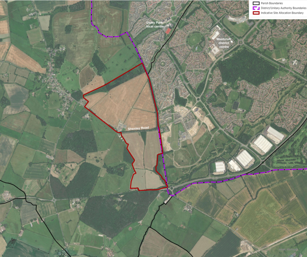
Figure 2: Shenley Park Site boundary and aerial plan
The urban area of Milton Keynes provides a wide variety of services, onward connections and amenities, with Central Milton Keynes lying around 6.5km to the north-east and Bletchley Town Centre around 5.5km to the east. The local area also includes Oxley Park local centre and Westcroft District Centre approx. 1.5km to the north-east of the Site, and a number of local primary and secondary schools.
The village of Newton Longville is located to the south east of the site. Development has been approved for up to 1,855 homes, an employment area, primary school, reserve site for a secondary school and associated open space and infrastructure, known as 'South West Milton Keynes' is located south of the A421 (between the Site and Newton Longville) and the approved layout has been indicated on the plan below (figure 3).
Further proposed development has been consented and is under construction at Tattenhoe Park to the east of the site boundary. This development is also indicated on the plan below and comprises up to 1,310 new homes, a local centre, primary school, community facilities, hotel, public house and open space and associated infrastructure.
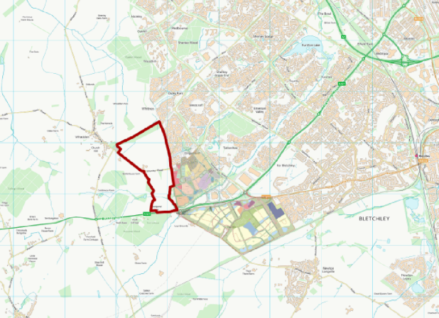
Figure 3: Shenley Park Allocation in its wider context (existing and planned development)
The Site is situated north of the A421, a key artery which connects Buckingham to the west (and beyond), into the City of Milton Keynes and the M1/further east. The Bottledump roundabout located at its south-east corner currently acts as the western gateway into Milton Keynes. Shenley Road bisects the site and provides access between Whaddon and Milton Keynes. The existing connectivity around the site is set out in figure 4 below.
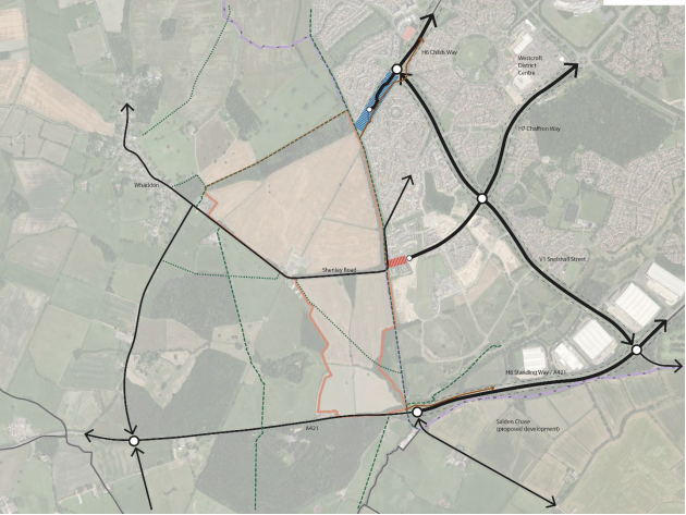
Figure 4: Existing vehicular connectivity
Extensive site review and analysis has been undertaken and this material is provided at Annex 1 to the Baseline Report which includes mapping of the opportunities and constraints as well as Site photographs. Section 2 of the Baseline Report also describes the key features and characteristics of the Site which has informed the preparation of the Framework Plan and SPD.
3.2 Key Placemaking Considerations and Design Influences
The site location, context and characteristics outlined above and in the Baseline Report are important in informing the appropriate design response for the site. The Baseline Report also explores the key site-specific structuring elements for the site (see figure 5) and design influences for the site. It includes an initial sketch design concept (see figure 6) which is the starting point for placemaking considerations.

Figure 5: Key Structuring Elements (Oct 2022)
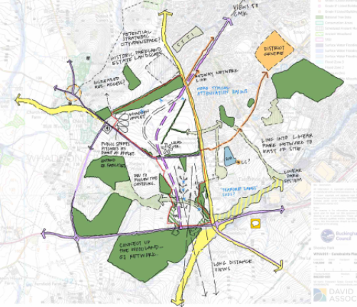
Figure 6: Initial Sketch Design Concept (Oct 2022)
The Initial Design Concept Plan built on the sketches in figures 3 and 4 and identified the following key structuring elements which have governed the evolution of the Framework Plan(s) set out in the SPD:
- Design response inspired by local Buckinghamshire villages and towns, recognising that development here should bridge an effective transition between 'town and country'
- Site layout in the southern part of the site is heavily influenced by the topography, with the link road (alignment and point of connection with the A421) dictated by the landform
- The northern part of the site has a local centre, community uses and associated public realm / open space at its heart, shaped by and incorporating existing green infrastructure elements on site
- The need to ensure that the landscape buffer to Whaddon marries effectiveness in terms of visual separation with its function as an integrator of people and nature between the two communities of Shenley Park and Whaddon.
- The retention of trees and hedgerows through and around the site is a key determining factor in the layout of the new place, respecting and enhancing the quality of the existing landscape setting, and respecting the local character and distinctiveness of the site's context.
3.3 Overarching Design Concept – Key Principles
The Baseline Report, at the end of Section 6, provides a suite of plans identifying the emerging Development Framework Principles (which are reproduced below for ease (using Baseline Report FIG references):
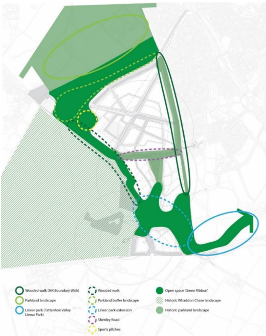
Overarching landscape strategy (FIG 3)
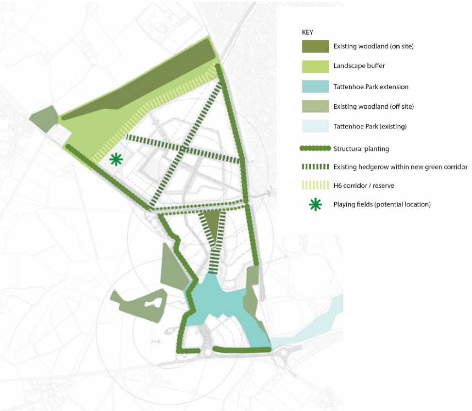
Proposed Green Infrastructure Framework (FIG 3a)
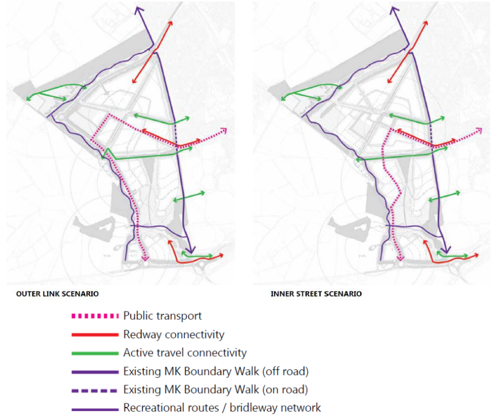
Note: the principles of connectivity for public transport and active modes are the same under each scenario; the difference relates to the routeing of the priority public transport link through the site reflecting each Link Road layout.
Proposed Framework for Public Transport and Active Modes (FIG 3b)
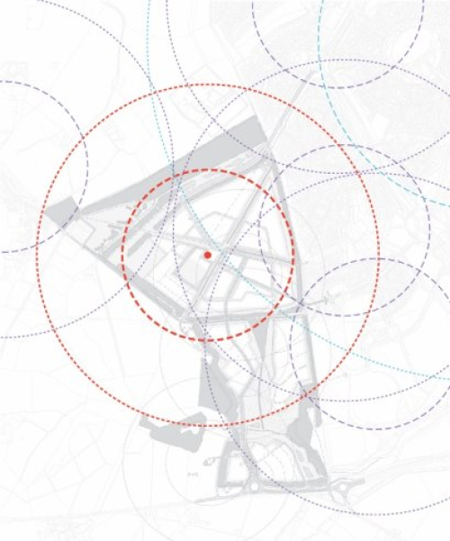
Note: A location for the mixed use local centre centrally within the northern neighbourhood of Shenley Park optimises the residential walkable catchment relative to both the Site and other local facilites in the adjacent village/residential areas
Walkable Catchments (local/district centre) (FIG 3c)
KEY:
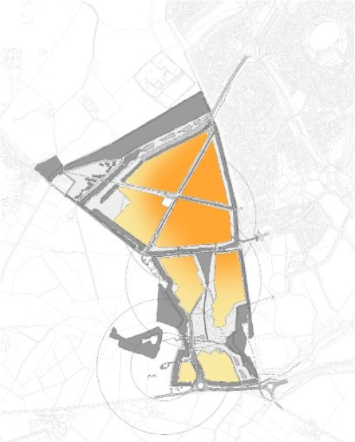
Darker Orange = higher intensity of activity (neighbourhood centre/mixed use) and higher density development forms reflecting proximity to MK edge and adjacent development character
to
Yellow = lower intensity: rural edge, landscape interface
Proposed Intensity of Activity/Residential Density (FIG 3d)
The key principles set out above are based on the following site specific key principles and which should be read in conjunction with the AVA Design SPD principles to also be applied:
(i) A development visibly shaped by its landscape and settlement context
- Key characteristics of the landscape and context to guide, inform and influence design development, including but not limited to the site layout and connectivity, scale, massing, materials and detailing (reference to Principle DES4 of the AVA Design SPD)
- Positive relationship with (rather than isolated from) Whaddon and the Western Flank of Milton Keynes
- Being in nature – the importance of proximity to landscape, easy access, walking into the wider area
- Positively and sensitively respond to the topography, strategic views and existing vegetation referencing local settlement patterns
- Defensible edges, whilst facilitating [safeguarding] connections now and into the future
- Development which protects, enhances, creates and connects biodiversity across the site (in accordance with Principle DES3 of the AVA Design SPD)
(ii) Creating a Sense of Place from the outset
- Creating a new, locally distinctive and welcoming place which facilitates positive engagement between different people and communities
- Creation of an integrated and useable Whaddon buffer which is a sensitive extension to the parkland character to Whaddon Hall and which provides opportunities for informal recreation (walking, picnic, outdoor exercise) connecting existing and new communities
- Clear focus for the new neighbourhood with a public square at the heart of the new neighbourhood creating a flexible space to encourage interaction, activity and dwell time, which is also capable of accommodating community uses and events
- Varying intensity/uses across the site; walkable neighbourhood focused around a compact neighbourhood core which is reachable within a 10-15 minute walk
- Responding to, and efficiently integrating and extending a rich network of existing Green Infrastructure in a sensitive way to provide a range of natural and amenity spaces for play and informal recreation and in accordance with Principle DES11 of the AVA Design SPD
- The place as bridging between 'town' and 'country' – in the extent and treatment of development edges, varying densities across the site, adapting village and suburban development forms in appropriate locations.
(iii) Quality in Public and Private Realm, Built Development, Hard and Soft Landscape
- High quality, good design at Shenley Park through its buildings, spaces, streets and infrastructure will need to be focused on delivering a strong sense of place and natural surveillance. Health, safety and well-being of residents should be at its heart and which will be derived through clear principles in the SPD and in accordance with the design principles in the AVA Design SPD and with National policy and guidance. A varied sequence of spaces and vistas aligned with focal buildings or existing landscape features should be created.
- Street trees and planting to be used to define the public and private realm and a sense of enclosure to be created through built form and landscape features, trees, hedges and walls.
- Sustainable Urban Drainage Systems will be integrated into the development in a way which positively respect and responds to the topography minimising the need for cut and fill and unnecessary exporting of soil. Their design will also provide biodiversity enhancements and will create landscape assets.
- All residential and non-residential buildings will incorporate appropriate and well-designed storage space to meet waste collection requirements and to encourage recycling.
- Key crossing points should provide for pedestrian/cyclist priority at the crossing of primary streets using well designed underpasses where appropriate.
(iv) Planning and Designing with the Long Term in mind
- Create a place that is resilient to climate change and maximises resource management minimising energy demand and consumption, and maximising energy efficiency. Building design will adopt a long term Fabric First and holistic approach and be orientated to benefit from natural light whilst balancing solar gain to take advantage of passive heating while reducing overheating risk. In recognition of adopted planning policy and guidance, Building Regulations requirements and the climate emergency declared by the council, all residential and non-residential buildings will need to incorporate high-efficiency and sustainable design features in order to reduce carbon and to maximise renewable energy generation (See VALP policy C3).
- The approach on the site should also take a lead in promoting sustainable green infrastructure and transport which will make a positive contribution to managing air quality and promoting mode shift to sustainable forms of travel through the incorporation of public transport priority routes. This will inform street design and hierarchy. Provision for charging points for electric vehicles should also be provided in accordance with the latest standards.
- Whilst some elements fall outside current policy requirements, the following are identified as potential long term objectives to bear in mind when designing and approving development on this site :
- P&R /MRT ambition to the west of the site to achieve a step change in sustainable transport for the wider conurbation (and benefit North Bucks communities)
- MRT route through site via H7 and emerging physical designs A421 – H6 futureproofing (including long term H6 to A421 strategic link)
- Reinstatement/reintroduction of wider Whaddon Chase GI as part of the forming of a strategic long term edge to the urban area [BC and MKCC cross border ambition]
- The SPD guidelines and Planning Application approvals processes will positively govern the quality of infrastructure and development ("designed not engineered")
- Buckinghamshire Council, and the developer, to have a commitment to good design, adoption and maintenance of high quality design, materials and management regimes
- Need for continued cross border liaison between BC and MKCC (officer & stakeholder level) on key cross border elements (education, transport, retail function, GI) in the interest of effective functionality of the new place
- A management plan should be provided at the outset and the scheme designed with longevity and easy maintenance in mind
- Opportunity for Role of Parks Trust as potential 'guardian body' for GI to ensure appropriate governance and legacy


