Shenley Park SPD
Part Six: Landscape, Open Space and Green Infrastructure
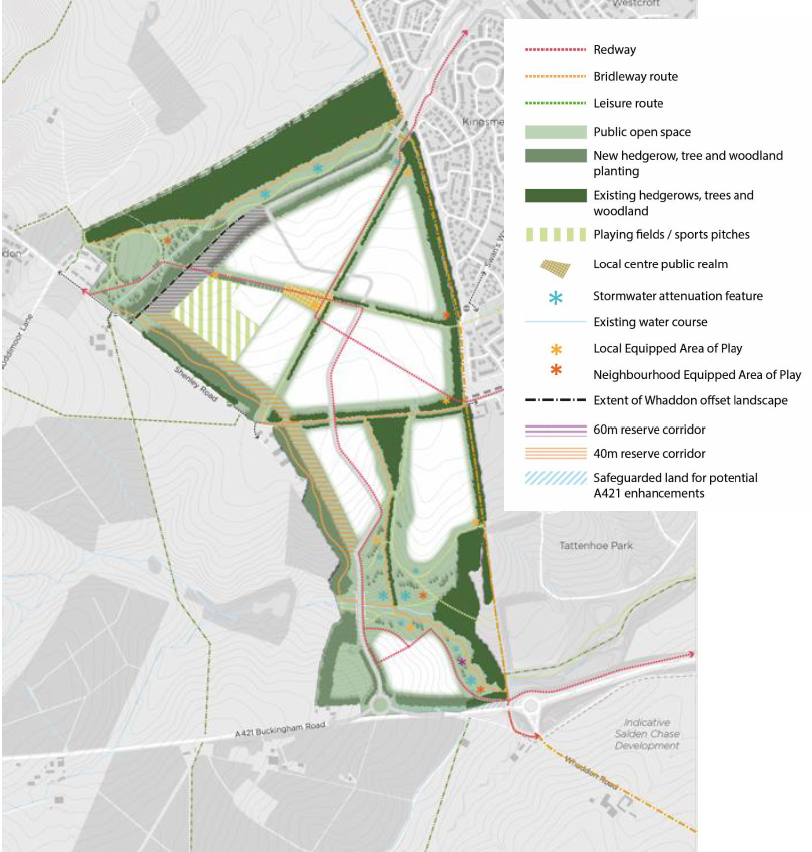
Figure 26: Landscape, Open Space and Green Infrastructure Plan (and key)
The presence of landscape features on site – including hedgerows, woodland and undulating topography – as well as around the margins of the allocation, coupled with the site's location relative to the remnants of the historic Whaddon Chase landscape mean that a landscape-led approach to design is entirely justified and reasonable and is set out in policy. As such, the landscape characteristics and existing mature green infrastructure has directly shaped the Framework Plan.
6.1 Landscape Strategy
This approach starts with the premise that re-profiling, cut-and-fill, and engineering techniques will be minimised (if not avoided) and the Site's topography and resultant character will be preserved wherever possible to create a distinctive form of context driven development.
The layout and design of the southern part of the site will clearly reflect the existing topography with streets and development arranged accordingly, resulting in a more intimate and informal character.
Within the northern part of the site, the layout and design is derived from the linear pattern of existing hedgerows with development.
The development will protect and retain existing hedgerows, trees and woodlands within and around the Site in situ and provide enhancements to the Briary and Bottlehouse Plantations. Existing green infrastructure of woodlands, trees and hedgerows will be retained in their entirety with the exception of one hedgerow which runs perpendicular to the A421 (as explained in the Baseline Report and annexes). The design of development and open space will enhance and/or create new connections between existing and proposed habitats to heighten levels of biodiversity across the site.
The landscape strategy is based around a connected corridor of landscape into and along the edge of the site as is explained in the Baseline Report and shown in FIG 3 included in Section 3.3 above). Applying the landscape buffers stipulated by VALP policies NE2/NE8 to the existing on-site green / blue infrastructure – hedgerows (10m); woodland (25m); ancient woodland (50m) and watercourses (10m) - has been taken as a starting point in defining development edges. The required offsets from existing woodlands and hedgerows will be accommodated to protect their long-term health with the landscape corridors contributing to wider green infrastructure enhancement and connectivity, amenity open space provision, habitat creation and SuDS provision for the development.
The site is located in the Whaddon Chase Biodiversity Opportunity Area (BOA) and design of landscape and green infrastructure will seek to protect, enhance, create and connect biodiversity to support coherent and resilient ecological networks as supported by Design Guidance.
It is expected that the Shenley Park OPA will seek to deliver a Biodiversity Net Gain (BNG) of at least 10% and to accord with the Biodiversity Net Gain SPDs of both Buckinghamshire and Milton Keynes.
6.2 Whaddon Offset (Buffer)
The setting of Whaddon will be preserved through the creation of a substantial open space in the north-west corner of Shenley Park. Based on design analysis undertaken (see Baseline Report) a 'Whaddon offset' of a minimum width of 150m between the extent of build development edges is required, providing a balance between visual separation and functional integration and community connectivity.
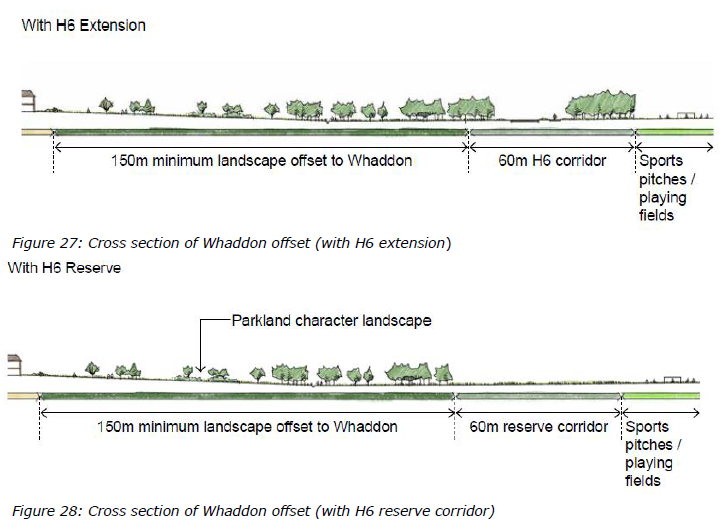
The Whaddon offset will have a parkland character, with trees and grass / wildflower meadow being the predominant features. Structural tree planting will be provided along the southern extent of the open space. More informal groupings and standalone specimens will be distributed through the main body of the space. The existing agricultural ditch will be retained and integrated into the design of the open space with measures taken to improve its ecological value where appropriate.
The open space will reflect the historic parkland character which exists immediately north of Briary Plantation, comprising meadow grass and trees.
Leisure routes will be integrated into the design of the space and walking and cycling access and a connection to the MK redway network will be accommodated within this area providing connectivity between Whaddon, Shenley Park and MK. Bridleway access will be integrated providing connectivity eastwards towards the MK Boundary Walk and westwards towards Whaddon and the wider bridleway network.
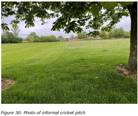
As part of the desire to create a 'welcoming place', the Whaddon offset should be designed as a shared space for informal recreation (activities such as picnicking and informal play and exercise) between the new and existing community to encourage community integration and cohesion. Within the offset, some informal sports provision such as an informal cricket pitch of a nature commensurate with the rural setting may be incorporated which will encourage participation in sport and recreation activities which has many physical and health benefits.
QUESTION FOR CONSULTATION
The Whaddon offset (buffer) is recommended to be designed as a shared landscaped space for informal recreation to encourage community connectivity and integration.
Given its rural context, the consultation on the SPD seeks to establish if there is a preference for the inclusion of an informal cricket pitch as part of encouraging this community integration as part of the Whaddon buffer.
If a clear preference is expressed during the consultation on the SPD for the inclusion of an informal cricket pitch in this location, then the final SPD will reflect this preference.
Whilst not forming part of the 'Whaddon offset' the creation of the Outer Link reserve corridor and arrangement of playing fields / sports pitches will set-back built development within Shenley Park further from the southern extent of Whaddon village, further increasing the physical and visual separation between the two settlements. Arrangements to secure its function and management as a reserve in perpetuity will be secured through the legal agreements to any planning consent.
6.3 Western defensible edge
A new defensible boundary to Milton Keynes will be created along the development's western edge using structural tree planting to be integrated with the site-wide green infrastructure.
At a site level, the western boundary of the site is already well-defined on the ground by field boundaries and Shenley Road and can be reinforced with a combination of a well-designed development edge and landscape design. Substantial areas of tree planting will be created along the western edge of the site.
The design approach to landscape planting should reflect the 'plateau' characteristic of the northern part of the site and the 'valley' characteristic of the southern part. This will manifest in a consistent woodland block as edge treatment for the northern part (north of Shenley Road) which will be a minimum of 40m in width, with a more flexible and organic width of woodland buffer along its length for the southern part of the site measuring between 10-40m in width (south of Shenley Road to the A421).
This edge treatment should incorporate potential access for walking, cycling and horse riding as well as providing biodiversity benefits and could also include orchards or allotments ('productive landscapes') of direct benefit to residents and which can help form an appropriate transition between the edge of the built form and countryside. Further guidance is provided in Section 7 under the relevant edge conditions studies.
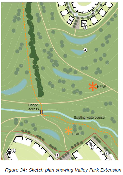
6.4 Open Space and extension to Tattenhoe Valley Park
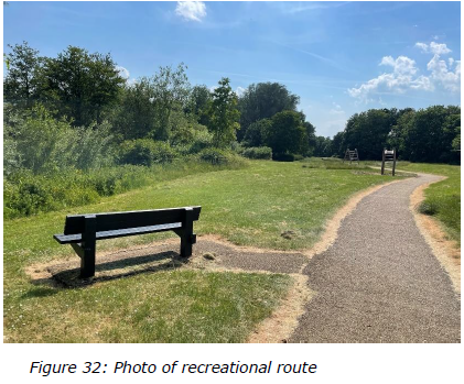
A Linear Park, running east-west along Tattenhoe Brook, will connect Milton Keynes to the open countryside through the site following the Landscape Strategy established in the Baseline Report and as depicted in Section 3.3 (FIG 3). This Park extends the existing Tattenhoe Valley Park to create a high-quality public space with integrated active travel routes (including bridleways), green infrastructure and naturalistic stormwater attenuation features, replicating these elements of the design ethos for the wider linear park network.
The open space network of Shenley Park will accommodate a range of active travel routes for walking, cycling and horse-riding where appropriate. These will include connections into the redway network of MK, connections to public rights of way around the periphery of the site and an extension to the
Tattenhoe Valley Park along the existing water course. The characteristics of the existing Tattenhoe Valley Park shall be continued westwards where the linear park runs into and through Shenley Park.
The existing public footpath within the site should be retained and incorporated into the development through the open space network to maintain connectivity. Routes shall be enhanced to improve their accessibility and durability. Path connections will be made between the linear park and the adjacent streets and development parcels. Cross-park permeability will be provided by bridge crossings for walking and cycling, located at appropriate locations and distances so as to create an accessible, safe and welcoming environment.
Design principles for the Valley Park Extension include:
- The park will be laid out to work positively with the existing landform and levels, minimising the need for reprofiling
- Features shall be vegetated
- Features will appear 'natural' with no engineering components prominently visible
- The soft landscaping shall comprise predominantly locally appropriate native species, reflective of the historic Whaddon Chase character.
- Development will generally 'front' on to the linear park with dual aspect properties integrated where necessary to provide passive surveillance to the open spaces and pathways
- Outdoor furniture such as benches at regular intervals, litter / recycling and dog mess bins shall be provided, consistent with the existing Tattenhoe Valley linear park
- Lighting shall be limited to the redways and primary paths with the linear park being generally a dark zone.
- Stormwater attenuation features will be positively integrated into the open space corridor, consistent in design character, scale and quality with such features within the existing Tattenhoe Valley Park to the east.
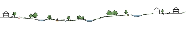
Figure 33: Example section through Valley Park Extension
- SuDS will be considered as an integral component of the development at all scales from individual building / plot to the attenuation basin. SuDS will be sensitively integrated across the development to provide stormwater attenuation functionality in streets (through elements such as swales) and development areas (such as formal ponds) as well as open spaces.
- SuDS features shall be designed to provide biodiversity value through habitat creation and contribute to the visual amenity of the development.
- SuDS features within the open space network shall appear as natural as possible, with engineered elements well designed to minimise their visual prominence.
- The drainage design solutions developed must respond sensitively and appropriately to the existing Site (including topography, vegetation, water bodies) to ensure the SuDS features can provide a wide range of benefits additional to the functional drainage including amenity, recreation, biodiversity and placemaking.
6.5 Open Space Requirements
The new development will be required to meet the ANGSt standards to meet additional demand arising from new development. Amenity green space will need to be provided on site. Sports and recreation facilities can be provided as required (VALP policy I2) on the same site where these are compatible with publicly accessible green infrastructure but need to be treated separately to accessible natural green space.
VALP Appendix C sets out the quantitative and accessibility standards for Accessible Natural Green Space (ANGSt).
The quantitative and access standards for the following outdoor sport and play facilities are set out in the Fields in Trust publication "Guidance for Outdoor Sport and Play: Beyond the Six Acre Standard";
- Locally Equipped Areas of Play (LEAP) aimed at children who can go out and play independently
- Local Areas of Play (LAPs) for very young children,
- Neighbourhood Equipped Areas of Play (NEAP) aimed at older children; and
- Multi Use Games Areas (MUGAs) and skateboard parks
The Framework Plan has indicated potential locations for equipped/designated play areas accord with the walking guidelines, catchment areas and the required buffer zones between activity zones and residential properties.
Fields in Trust benchmark guidelines suggest that both MUGA/s and skate parks are required as part of new development, which for Shenley Park would total 8,625sq.m. Hard surfaced BMX track/s or BMX pump track/s could also be provided to help meet the benchmark guideline and which may be considered more appropriate within a linear park/ rural edge location.
QUESTION FOR CONSULTATION
Access to outdoor sport and play facilities is important to create local opportunities for exercise and play for all ages and to promote healthy lifestyles and inclusive communities but their design should also be commensurate with their setting and the character of the open space.
The consultation on the SPD seeks to establish if there is a preference for the inclusion of a skate park or a BMX track as part of any provision.
If a clear preference is expressed during the consultation on the SPD for the inclusion of a skateboard park or BMX track, then the final SPD will reflect this preference.
The Framework Plan shows a range of formal sports provision can be accommodated within the site and which is appropriate for a landscape led scheme. The starting point for calculating the requirement are the standards set out in VALP Appendix D and a further breakdown is included in the Baseline Report.
The precise type, and amount of play space and sports provision will depend on the existing facilities in the area at the time of development (which may include South West Milton Keynes and the provision secured there) as well as the accessibility and capacity of those facilities. This should be the subject of discussion/negotiation as part of planning applications. The precise contribution or provision will then be secured as part of a Section 106 Application associated with a future application.


