Shenley Park SPD
Part Five: Access and Connectivity
The SPD Design Framework for Shenley Park has been driven by placemaking considerations. Paramount in this process is the need to create a distinctive and high quality development which in both its form and its function, reflects its setting and integrates well with its surroundings.
Site characteristics and context are the primary drivers for design and layout. However, Shenley Park sits at a critical location within the wider North Bucks / West MK interface relative to key infrastructure. This is made clear through the existence– and content – of Policies WHA001 and SD15.
Because of its importance to wider connectivity, decisions on the layout of development and infrastructure ('form') and connectivity with other places ('function') at Shenley Park cannot be made in isolation from wider considerations. Further, decisions on some of the strategic aspects of future connectivity and longer term function of the infrastructure network are not yet able to be made. This is because they are at an early stage of planning or policy processes and need to be informed by more detailed transport modelling associated with a planning application as well as outputs from the strategic transport studies such as the A421 Corridor Study. There are also proposals in the early stages of development for a Mass Rapid Transit system for MK and/or the potential for a Park and Ride to the SW of the City (which may be sited to the west of the Bottledump roundabout).
Annex 5 of the Baseline Report sets out a number of potential connectivity scenarios explored as part of the preparation of the SPD. The characteristics of the scenarios are set out in Section 6 of the Baseline Report.
Following engagement with stakeholders there is a need in the SPD to provide a balance between flexibility around future transport infrastructure and certainty on what is expected to be provided on site. Therefore, the SPD provides a Development Framework for the site which adopts a common approach to core key design and placemaking principles to provide for appropriate connectivity and accessibility for the allocated site, but which maintains the ability to provide strategic connectivity through the site if required.
Whether this strategic connectivity is required as part of development of the Shenley Park allocation, or is required to be safeguarded as part of Shenley Park to ensure future connectivity is not prejudiced will be determined through the consideration of the planning application(s) for the site.
Figure 9 below illustrates the Access and Connectivity Strategy with key principles explained in sections below under the following headings:
- Vehicular Access;
- Link Road;
- Pedestrian and cycle connections;
- Shenley Road, and access between Shenley Park and Whaddon village
- Public Transport
- Key connections; a series of detailed sketch plans providing further design guidance are provided for:
- MK Boundary Walk
- A421 Redway
- H6 Redway underpass
- Shenley Road Crossing
- H7 Hayton Way connection
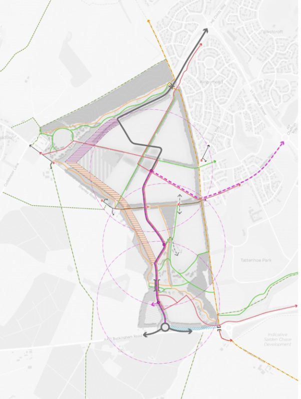
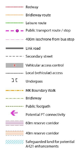
Figure 9: Access and Connectivity Strategy Plan (and key)
5.1 Vehicular Access
The site abuts the A421/Bottledump Roundabout at the gateway into MK, and will be accessed directly off the A421. The precise location of the new A421 junction will be selected so as to minimise the need for reprofiling of existing site levels and allow for grade separated crossings of the link associated with the linear park extension, but it is anticipated that this will be via a new roundabout which will be constructed within the confines of the site (and adjacent highway land north of the A421 carriageway as necessary). The junction with the A421 will be designed as a green gateway to Shenley Park, with landscape and planting being the dominant features. Development will be set behind substantial structural planting. Further guidance is provided under key spaces and places (section 7 of the SPD).
5.2 Link Road
The policy requires a 'link road' through the site 'connecting the A421 and or H6/H7'.
Annex 5 of the Baseline Report set out the analysis and consultation which has informed the SPD design response to connectivity through the Shenley Park site.
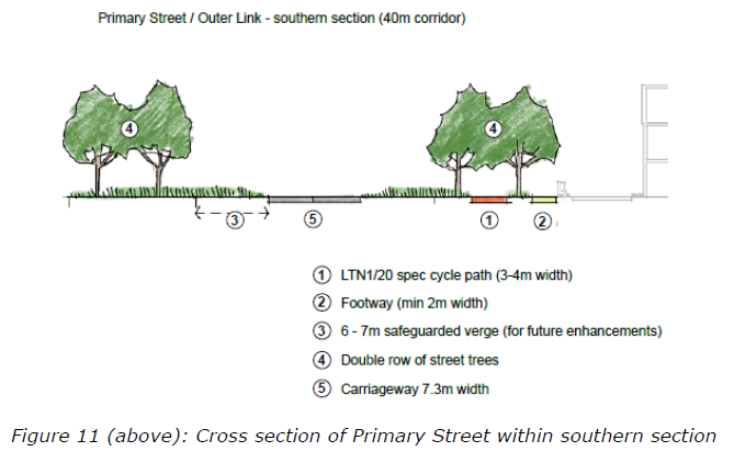
A Link Road will run through the development area from the A421 to H6 Childs Way to provide the required degree of connectivity. Its scale and character through the development parcels will follow the principles set out in the cross section shown below in order to maintain an appropriate street design through the development area and create a well-designed public realm and streetscape. Tree planting will extend along the entire length of the link road to create a tree-lined corridor.
The preferred alignment of the link road (subject to transport modelling assessment at the application stage) will border the eastern edge of the Local Centre, allowing for a more pedestrianised public realm in Shenley Square with integrated green infrastructure. The corridor in which the link road sits will also accommodate walking and cycling routes as appropriate. The link road will be designed so as to remain operational and safe for users in times of flood.
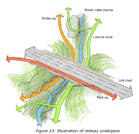
The new link road will cross the MK Boundary Walk at the point it meets H6 Childs Way, with an underpass to be constructed west of the current Boundary Walk within the boundary of the Shenley Park site resulting in a minor diversion to the alignment of the MK Boundary Walk but ensuring priority for uninterrupted walking/cycling/riding along this important public right of way. This approach is adopted successfully elsewhere in Milton Keynes, avoiding 'at grade' Pegasus crossings which interrupt the continuous links of leisure routes and Redways throughout the area, inconveniencing users and downgrading the priority to be given to safe active and sustainable movement. Further guidance is set out in the key connections section below.
A link road connection into H7 Hayton Way is not the favoured approach; this connection is not allocated as a safeguarded transport corridor in Plan:MK and its design and form as constructed through Tattenhoe Park means it will only ever function as a lower order street; see Baseline Report Annex 8.
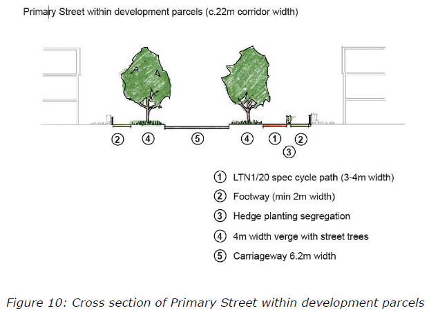
Safeguarded land 'Outer link' and A421
The principle of 'infrastructure corridor reserves' is a well-recognised design and development principle in the wider area which defines a landscaped corridor or reserve within which green and grey infrastructure for vehicles, cycles and pedestrians (as well as utilities services) can be implemented in phases over time.
The Framework Plan also safeguards land for the future provision of an 'outer link' to connect the H6 safeguarded transport corridor with the A421. The outer link option would have a more strategic function for vehicular movements from the A421 to the grid network offering greater capacity for through traffic if this is determined as required through transport modelling and evidence.
This is necessary to avoid the link road through the developable extent having to be designed to a strategic function at the expense of appropriate street design. The outer link reserve is allowed for through provision of a 60m reserve corridor parallel to the northern boundary and a 40m reserve corridor along the western boundary. It is acknowledged that implementation of the safeguarded corridor to the western boundary would result in the loss of the outbuildings associated with Bottlehouse Farm. These are considered non-designated heritage assets (NDHAs) and therefore, if the 'outer link' is to come forward on this alignment, and is sufficiently justified, a level 3 recording of the buildings will be required.
The A421 is the principal route between North Bucks and Milton Keynes and forms part of the wider strategic transport network for the two authorities. Assessment of the A421 is currently underway in the context of the evidence base for future local plan reviews and committed developments in the wider area. For Shenley Park, the Framework Plan safeguards land to the northern side of the A421 to allow for the dualling of the road between Bottledump Roundabout and the proposed site access with structured landscaping to create a buffer between the road and the new development, should dualling be evidenced as required (See Section 7 for further guidance on this edge treatment).
The approach set out in this SPD and the Development Framework offers the ability to address transport priorities as they evolve and maintain the ability to implement highway designs capable of meeting current and medium term demands as well as taking a long-term approach to safeguarding future potential growth options in line with best practice design approach set out in the AVA Design SPD.
Adopting this approach in the SPD will provide a design framework for the site which allows early development of Shenley Park to meet local housing requirements /local plan objectives without compromising the ability to also meet future connectivity or transport capacity solutions.
Subject to the outcome of transport modelling and strategic transport/public transit connectivity considerations as part of planning applications, the outer link and A421 dualling may be required to be delivered as part of the Shenley Park development. Alternatively, applications will require the safeguarding of reserve corridors to ensure should an outer link connection and/or dualling of the A421 be required at a future date, that these can be accommodated. Delivery of the 'outer link' for strategic traffic should avoid the need for two connections into MK (via H6 and H7) carrying strategic traffic through the site.
5.3 Pedestrian and cycle connections
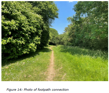
Provision for walking and cycling (along straight and direct routes where practicable) is a priority for Shenley Park which benefits from a good number of connections in the form of existing Public Rights of Way, bridleway links and Redways. Active travel routes are to be implemented between Whaddon and the new development along a downgraded Shenley Road (see below) and across various points along the MK Boundary Walk. Redway connections will be extended from H6, H7 and the A421 into the Site to facilitate easy connection into Milton Keynes and also to adjacent new development and its schools and amenities (see key connections section for further guidance). Redway routes will be extended through Shenley Park towards Whaddon. Recreational routes and bridleways will run along all boundaries of the Site and connect through to Milton Keynes and into the wider Whaddon Chase landscape and footpath/bridleway network.
The existing public footpath crossing the southern part of the site is to be retained and integrated into the development where practical. Where this is not practical, it should be diverted to run through the open space network to maintain connectivity. Routes shall be enhanced to improve their accessibility and durability and connections created to the existing Public Right of Way network to provide wider recreational connectivity.
Integrating the proposed development into Milton Keynes and providing connections into Whaddon is essential and therefore, walking routes will be provided between Shenley Park and Whaddon to the north-west and to Milton Keynes to the east. Bridleway links should be created through the open space corridors of Shenley Park to link in with the routes alongside Briary Plantation and to the south through Tattenhoe Park providing wider bridleway connectivity between Shenley Park, Whaddon, Milton Keynes and the surrounding rural landscape.
The internal streets in the southern part of the site will respond to the existing landform to provide access for walking, cycling and vehicles, minimising the need for extensive reprofiling.
New active travel connections between Shenley Park and the adjacent MK Boundary Walk which runs along the eastern boundary will be created to coincide with existing links to streets and open spaces within Tattenhoe and Kingsmead.
5.4 Shenley Road, and access between Shenley Park and Whaddon village
Shenley Road is a heavily landscaped rural route which currently provides access between Coddimoor Lane and Whaddon village to the Milton Keynes urban area (via Swans Way and Guildford Avenue to the V1 Snelshall Street).
Consultation with local stakeholders through the SPD preparation indicated a preference to restrict vehicular through traffic along this route. At the same time, the character of that part of Shenley Road running through the site lends itself to downgrading to become a focus for active travel movements through the site.
As such, Shenley Road will be stopped up as a through-route for vehicular traffic part way along its main horizontal axis (see Figure 9 connectivity plan) and will be downgraded to an active travel (walking and cycling route), with access along the first part of Shenley Road from Whaddon retained to serve existing properties. This allows it to be preserved as a rural lane. There are examples in Milton Keynes where this approach has been adopted with the use of simple bollards to 'stop up' the road to vehicular traffic (as shown in the images below).
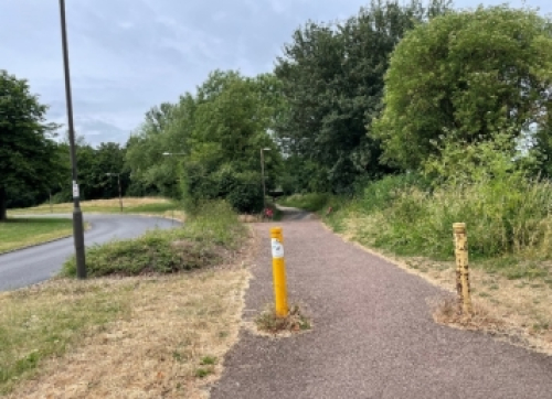
Figure 15: Stopped up route retaining landscape ('Before and after' image)
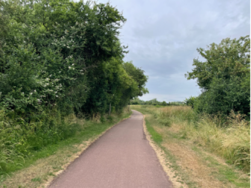
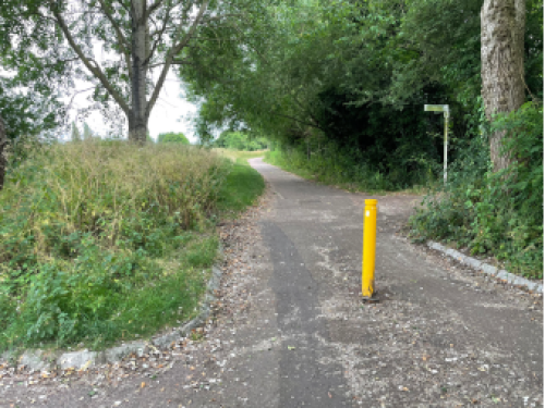
Figure 16: Example of downgraded routes (left) and use of bollards (right)
The section below on 'key connections' includes further information on the approach advised for the crossing of Shenley Road.
QUESTION FOR CONSULTATION
Despite the stopping up of Shenley Road through the site, there remains an option to maintain some degree of vehicular connectivity between Whaddon village and Shenley Park (see two diagrams (Figs 17 and 18) below).
The consultation on the SPD seeks to establish if there is a preference for one of the two options below.
If a clear preference is expressed during the consultation on the SPD for either option then the final SPD will reflect this preference.
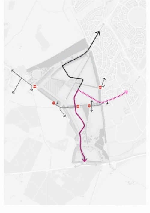
Fig 17 (left): No vehicular connectivity possible between Whaddon Village/Coddimoor Lane and Shenley Park (no access to A421 or Milton Keynes via H6/H7)
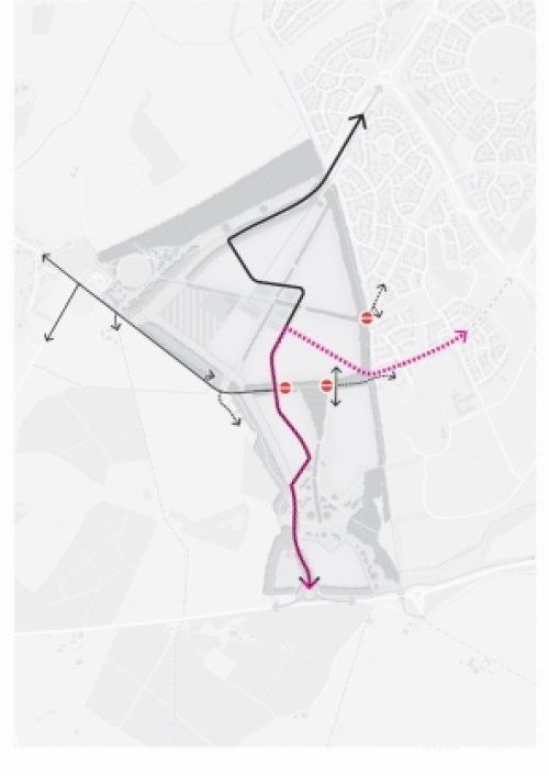
Fig 18: (right) Indirect vehicular connectivity between Whaddon Village and Shenley Park (via Coddimoor Lane/Shenley Road to access the north-south primary street through the new development)
5.5 Public Transport
Connectivity for public transport (including Mass Rapid Transit) will be improved or created between Shenley Park, Milton Keynes and Bletchley train station. The Framework Plan includes a priority public transport link between the A421 access via the Shenley Park local centre to connect into H7 Hayton Way, the primary point of connection into Milton Keynes (via Westcroft District Centre) considered most suitable for public transport (as it is not a safeguarded transport corridor and does not have the form or function to carry strategic traffic).
A dedicated public transport access route will connect into H7 via the downgraded Shenley Road (closed off to other vehicles) having run along the eastern edge of the Local Centre to allow for a more pedestrianised public realm in Shenley Square with integrated green infrastructure. This will enable sustainable transport and public transport priority at the outset and draw on the commitment of both Buckinghamshire and MK City Councils' commitment to a step change towards sustainable transport investment through public transport priority and vehicle restraint measures.
Provision for Future Park and Ride
There is an aspiration as part of a move to a more sustainable public transit network to locate a Park and Ride facility along the A421 to provide access to and from this part of North Bucks and Milton Keynes. No site has yet been identified, but it is likely to fall within the Buckinghamshire area to the west of Shenley Park.
As such, it is prudent to safeguard a connection west of the primary street to the western boundary of the Shenley Park to allow for future public transport connectivity from a Park & Ride facility north of the A421 to the Link Road and/or outer link to connect with the priority public transport route through Shenley Park (as shown in Figure 19).

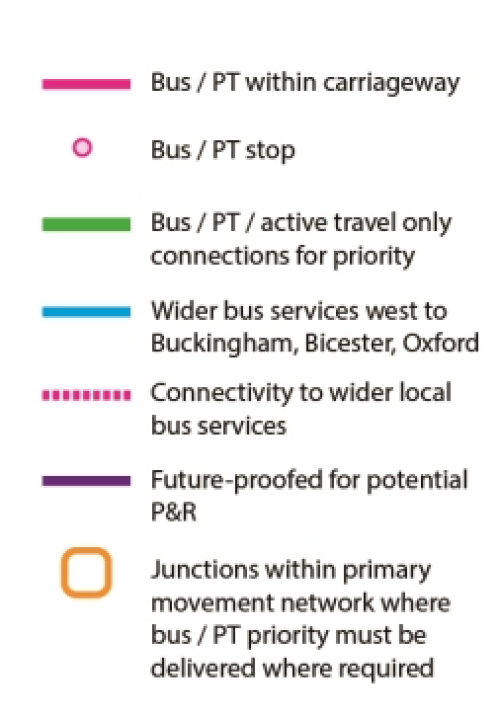
Figure 19: Connectivity for Public Transport Plan (with key)
5.6 Key Connections
The following section of the SPD includes a series of detailed sketch plans providing design guidance for those key connections identified in the SPD and Framework Plan in the locations shown boxed green in the plan below.
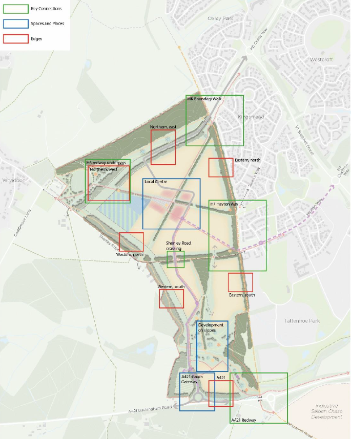
Figure 20: Location Plan for Key Connections detailed below
MK Boundary Walk (refer to Figure 20 for location)
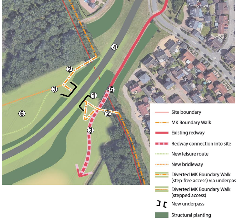
Figure 21: Sketch plan and principles for MK Boundary Walk crossing (and key)
- An underpass crossing will be provided for the H6 Childs Way connection to provide continuity to the MK Boundary Walk, avoiding the need for pedestrians, cyclists and horse riders to cross vehicular carriageways and maintaining uninterrupted access of the leisure and redway networks
- The MK Boundary Walk will require a minor diversion west of its current alignment within the Shenley Park site to facilitate the construction of the underpass and minimise loss of green infrastructure
- Redway, bridleway and leisure routes extending towards the north-west corner will be laid out to connect to the MK Boundary Walk providing direct and convenient access to the underpass
- The alignment of the connection to H6 Childs Way shall be laid out to minimise the loss and/or disturbance to Briary Plantation
- The existing H6 Childs Way redway will be extended into the site, providing direct, safe and convenient active travel connectivity between Shenley Park and Milton Keynes
- The 50m wide protective buffer of 'parkland character' landscape for Briary Plantation ancient woodland shall be maintained as much as possible
A421 Redway (refer to Figure 20 for location)
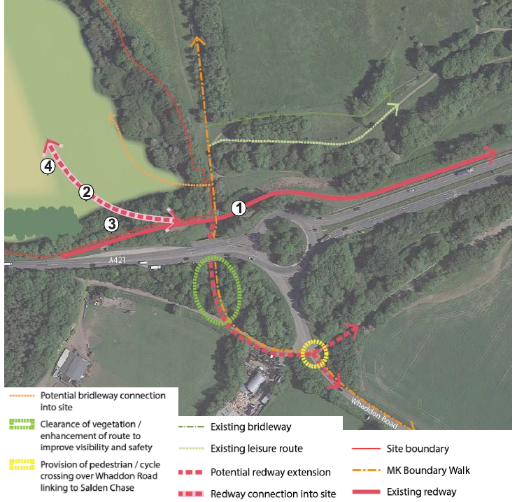
Figure 22: Sketch plan and principles for A421 Redway connection (and key)
- The existing A421 Redway (a designated 'Super-Redway' within the MK network) will be extended with a connection made into the site, providing direct, safe and convenient active travel connectivity between Shenley Park and Milton Keynes
- The redway connection shall be aligned in order to provide safely accessible connectivity and which works with the existing landform and levels, minimising the need for earthworks
- Disturbance and/or loss of existing vegetation shall be minimised
- The redway will run directly adjacent to or through the development in order to create a safe and overlooked route
H6 Redway underpass (refer to Figure 20 for location)
- In the event of the H6 Childs Way being extended westwards to Shenley Road through the 60m reserve an underpass will be provided
- The underpass will be positioned on the line of the redway providing direct and uninterrupted active travel connectivity between Shenley Park (esp the primary school and playing fields) and Whaddon village
Shenley Road crossing (refer to Figure 20 for location)

Figure 24: Cross section of Shenley Road crossing
- The rural lane character of Shenley Road will be preserved through the stopping up of vehicular access along its east west extent through the site
- Existing green infrastructure is to be retained and appropriate offsets maintained except for localised areas where access is required
- This section of Shenley Road will become a walking and cycling-focused route with a limited number of low speed north south vehicular crossings permitted
- The vehicular crossing points shall be located and designed to minimise disturbance and/or loss of existing green infrastructure
- Junction and highway design shall provide priority for walking and cycling east-west
- Development shall be set back the appropriate distance from existing green infrastructure, in accordance with policy requirements
- Residential development will generally be arranged to 'front' on to the Shenley Road corridor and vehicular crossings
H7 Hayton Way connection (refer to figure 20 for location)
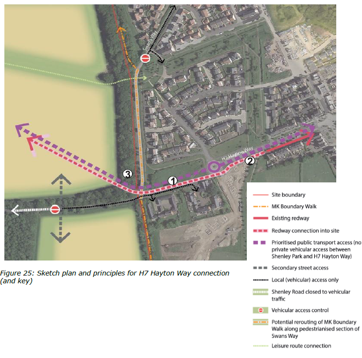
Figure 25:Sketch plan and principles for H7 Hayton Way connection (and key)
- A new connection between Shenley Park and Hayton Way will be provided for public transport, walking and cycling
- A connection will be made to the existing redway within the Hayton Way corridor providing direct and safe connectivity between Shenley Park and Milton Keynes
- Loss and/or disturbance to existing vegetation along Shenley Road/Swan's Way shall be minimised


